Guestuser: Login or enrol?
- Home
- Main Display
- Main Display (Old)
- Find a Walk
- Display INTRODUCTION
- DONATE
- Click below for your
profile & contributions
guestuserOverviewFor more map options click on any overview map area or any detail map feature.Detail Map FeaturesFind Suggested Walks
Find hill, mountain, island, coastal feature.Videos

Recent Contributions
 Get Notifications
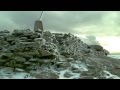
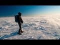
Carrauntoohil: Above the Clouds: 360 Degree Cloud Inversion
Mangerton & Stoompa
Carrauntoohil: Above the Clouds: 360 Degree Cloud Inversion
Seefin Mountain West Top: Great paths, closed boardwalk
Broaghnabinnia West Ridge and Stumpa Duloigh Traverse
Proctor High Mark: A rocking stone not a rolling one
A tough but rewarding day
Proctor High Mark: Find the gaps in the walls to find the highpoint
Clapham High Mark: Find the gaps in the walls to find the highpoint
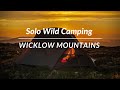
Interesting route around Trooperstown, Wicklow.
Parson's Pulpit: Short trek to summit through Burren type landscape
Cahas Surveying: Changes to Arderins etc
Conditions and Info
Use of MountainViews is governed by conditions and a privacy policy.
Read general information about the site.
Opinions in material here are not necessarily endorsed by MountainViews.
Hillwalking is a risk sport. Information in comments, walks, shared GPS tracks or about starting places may not be accurate for example as regards safety or access permission. You are responsible for your safety and your permission to walk.
See the credits and list definitions.Video displayWicklow Area W: Baltinglass SubareaPlace count in area: 115, OSI/LPS Maps: 28B, 55, 56, 61, 62, AWW, EW-DM, EW-LG, EW-WE, EW-WS
Highest place: Lugnaquilla, 924.7m
Maximum height for area: 924.7 metres, Maximum prominence for area: 905 metres,
Places in area Wicklow:
Cen: Glendalough North:Brockagh Mountain 556.9mBrockagh Mountain NW Top 549.5mBrockagh Mountain SE Top 471.7mCamaderry East Top 677.3mCamaderry Mountain 698.6mConavalla 734mTomaneena 682.4m
Cen: Glendalough South:Carriglineen Mountain 456.6mCullentragh Mountain 510mDerrybawn Mountain 476.1mKirikee Mountain 474.5mLugduff 653.2mLugduff SE Top 638mMullacor 660.7mTrooperstown Hill 430m
N Cen: Tonelagee:Carrignagunneen 561mFair Mountain 571.2mStoney Top 713.7mTonelagee 815.8mTonelagee E Top 668mTonelagee South-East Top 545.8m
NE: Bray & Kilmacanogue:Bray Head Hill 238.9mCarrigoona Commons East 242mDowns Hill 372.9mGreat Sugar Loaf 501.2mLittle Sugar Loaf 342.4m
NE: Djouce:Djouce 725.5mKnockree 342.1mMaulin 570mTonduff 642mTonduff East Top 593mWar Hill 684.8mWhite Hill 631.1m
NE: Fancy:Ballinafunshoge 480mKanturk 527.4mKnocknacloghoge 532.4mLuggala 593.3mRobber's Pass Hill 508.9mScarr 640mScarr North-West Top 559.8mSleamaine 430m
NE: Vartry:Ballinacorbeg 336mBallycurry 301mDunranhill 342mMount Kennedy 365.9m
NW: Blessington:Carrigleitrim 408mLugnagun 446.2mSlieveroe 332mSorrel Hill 599.5m
NW: Mullaghcleevaun:Black Hill 602.2mCarrigshouk 572.5mCarrigvore 682.4mDuff Hill 720.8mGravale 719mMoanbane 703mMullaghcleevaun 846.7mMullaghcleevaun East Top 796mSilsean 698m
S: Aughrim Hills:Cushbawn 400mKilleagh 249mMoneyteige North 427mPreban Hill 389m
S: Croaghanmoira:Ballinacor Mountain 529.3mBallycurragh Hill 536mBallyteige 447mCarrickashane Mountain 508mCroaghanmoira 662.3mCroaghanmoira North Top 579.5mFananierin 426mSlieve Maan 547.8mSlieve Maan North Top 546.1m
S: Croghan Kinsella:Annagh Hill 454mCroghan Kinsella 606mCroghan Kinsella East Top 562.1mSlievefoore 414m
S: Shillelagh Hills:Lakeen 357mMonaughrim 206mSeskin 344mStookeen 420m
S: Tinahely Hills:Ballycumber Hill 429.7mEagle Hill 296mMuskeagh Hill 398.2m
SE: Wicklow South East:Ballinastraw 284mBallyguile Hill 188mBarranisky 280mCarrick Mountain 381mCollon Hill 238mKilnamanagh Hill 217mWestaston Hill 270m
W: Baltinglass:Ballyhook Hill 288mBaltinglass Hill 382mCarrig Mountain 571mCarrigeen Hill 298mCloghnagaune 385mCorballis Hill 258mKeadeen Mountain 653mSpinans Hill 409mSpinans Hill SE Top 400mTinoran Hill 312m
W: Cen Lugnaquilla:Ballineddan Mountain 652.3mBenleagh 689mCamenabologue 758mCamenabologue SE Top 663mCloghernagh 800mCorrigasleggaun 794.6mLugnaquilla 924.7mSlievemaan 759.7m
W: Donard:Brewel Hill 222mChurch Mountain 544mCorriebracks 531mLobawn 636mSlievecorragh 418mSugarloaf 552mTable Mountain 701.7mTable Mountain West Top 563m
Note: this list of places includes island features such as summits, but not islands as such.
For origin of name, see Spinans Hill. Wicklow County in Leinster Province, in Carn List, Andesite & andesitic tuff Bedrock
Height: 400m OS 1:50k Mapsheet: 56 Grid Reference: S93044 91136
Place visited by 73 members. Recently by: No1Grumbler, nupat, NualaB, Kaszmirek78, mickhanney, John.geary, Ansarlodge, SenanFoley, oreills8, simoburn, annem, JoHeaney, hibby, loftyobrien, davsheenI have visited this place: NO (You need to be a logged-in member to change this.)Longitude: -6.616069, Latitude: 52.963284 , Easting: 293044, Northing: 191136 Prominence: 40m, Isolation: 1.2km
ITM: 692972 691175 , GPS IDs, 6 char: Spn400, 10 char: SpnnsHlSET
Bedrock type: Andesite & andesitic tuff, (Donard Andesite Member)
Brusselstown Ring is at the SE end of Spinans Hill. This fort is mentioned in several Irish annals as Dún Bolg [PNCW]. Spinans Hill SE Top is the 959th highest place in Ireland.
Linkback: https://mountainviews.ie/summit/841/COMMENTS for Spinans Hill SE Top (Cnoc na Spíonán (mullach thoir theas)) 1 2 Next page >>  Follow this place's comments


MountainViews.ie, a Hill-walking Website for the island of Ireland. 2400 Summiteers, 1480 Contributors, maintainer of lists: Arderins, Vandeleur-Lynams, Highest Hundred, County Highpoints etc

 Lauranna
 Lauranna
 Leatra
 Fergalh
 billbaggins
 Fergalh
 Fergalh
 Fergalh
 simon3
 Visit our Facebook page.