Members and Supporters, the MountainViews Committee requests your help to meet the costs of the website and of other activities such as insured events or publications.
Feature count in area: 115, by county: Wicklow: 108, Kildare: 4, Wexford: 2, Carlow: 3, of which 1 is in both Wexford and Wicklow, of which 1 is in both Carlow and Wicklow,
OSI/LPS Maps: 28B, 55, 56, 61, 62, AWW, EW-DM, EW-LG, EW-WE, EW-WS
Highest Place: Lugnaquilla 924.7m
Starting Places (205) in area Wicklow: 1916 Memorial Car Park, Aghavannagh Ow Bridge, Aghowle Wood, Altidore Wood Entrance, Annacurra National School, Annalecka Bridge, Asbawn Brook L8350, Aughrim National School, Ballard Road, Ballinabarny Gap, Ballinagappoge Bridge Layby, Ballinagappoge Mountain Hairpin, Ballinagore, Ballinahinch Wood, Ballinastoe MBT CP, Ballinastraw South, Ballineddan Upr Fork, Ballinfoyle Upr Cross, Ballycoog, Ballycreen Brook Bridge, Ballycumber, Ballycumber Bridge, Ballycumber Lane, Ballycumber Wicklow Way, Ballylerane, Ballylow Bridge, Ballylusk Quarry, Ballymanus Lane, Ballymoyle Shooting Lodge, Ballynultagh Gap, Ballynultagh Lane, Ballyreagh Wood, Ballyross Forest, Ballysmuttan Long Stone, Baravore, Barnbawn South, Barranisky North, Barranisky West, Bohilla Land Roundabout, Bohilla Lane Mid, Boranaraltry Bridge, Bray Harbour, Brewel West, Brittas Bay North CP, Buckroney Sand Dunes CP, Bus Terminus, Camera Hill Track Cross, Castletimon Wood North, Clara Vale, Clone House Road, Clonegal, Cloon Wood Cp, Coate Bridge, Coolballintaggart Ledge, Coolbawn House Lane, Cransillagh Brook , Crone Wood CP, Crossbridge, Crossoona Rath, Cummer Wood South, Curtlestown Wood CP, Deputy's Pass CP, Derralossary Church, Derry River Bridge, Devil's Glen CP, Devil's Glen Wood, Djouce Wood Calary, Djouce Wood Lake, Djouce Wood Long Hill, Donard, Donnelly's Lane Car Sales, Drumgoff Forest, Dunranhill North, Dunranhill SE, Dunranhill South, Dwyer McAllister Cottage CP, Enniskerry, Fentons Pub, Fitzsimons Park GAA, unuseableFlemings Footbridge Glen Rd, Gap Pub, Gap Road, Glen Beach CP, Glen of the Downs CP, Glenbride Lane, Glenbride Lodge, Glencree Reconciliation, Glendalough, Glenealy GAA, Glenmacnass Tonelagee CP, Glenmalure Hostel, Glenmalure Lodge, Glenmalure Waterfall, Glenview Hotel, Gowle House, Great Sugar Loaf CP, Grove Bar, Heffernans Well Wood, Hill View, Hollywood Glen, JB Malone CP, Johnnie Fox Pub, Keadeen NE trail, Keadeen Trailhead, Kevins Way Footbridge, Kilbride Army Camp Entrance, Kilcandra South, Kilcommon View, Killalongford Wood, Kilmacrea Cross Roads, Kilranelagh House Gate, Kilruddery Car Park, Kilruddery Cottages, Kings River, Kippure Bridge, Kippure Estate, Kippure Transmitter Gate, Knickeen Cross, Knocknaboley Lane Leeraghs Bog, Knocknaboley Lane Stone Cottage, Knockrath Little, Knockree west, Kyle Loop North, Lackan Wood S, Lake Dr Fraughan Brook, Lake Drive, Lake Park Cross, Lake View Pub, Laragh Free Car Park, Laragh NSch, Lead Mines CP, Liffey Bridge, Liffey Head Bridge, Lough Bray Lower, Lough Bray Upper, Lough Tay North Viewing Point, Lough Tay Wicklow Way CP, Luglass Lane L97561, Lugnagun Track, Macreddin Village, Mangans Lane, Military Road Carrigshouk Hill, Military Road Inchavore River Nth, Military Road Inchavore River Sth, Military Road NW Lough Tay, Military Road Ballyboy Bridge, Military Road Cloghoge Brook, Military Road Croaghanmoira, Military Road Fananierin, Military Road LaraghWicklow Way, Military Road Slieve Maan, Monspolien Bridge, Moortown House, Mountain Rescue HQ, Muskeagh Little Wood, Nahanagan Lough NE, Novara Avenue, Bray, Oiltiagh Brook Knickeen, Old Bridge Cross, Old Bridge Scouts , Old Wicklow Way entrance, Paddock Hill SE, Pier Gates CP, Powerscourt Waterfall CP, Putland Road, Quintagh East, Raheen Park CP, Raheenleagh East, Railway Walk CP, Rathdrum Railway Station, Rednagh Wood, Rocky Valley, Roundwood, Sally Gap, Sally Gap N, Seefin Trailhead, Seskin SE, Shankill Tributary Bridge, Shay Elliott, Sheepshanks Bridge, Shillelagh, Slievecorragh Track, Slievefoore South, Sraghoe Brook, St John's Church, St Kevins Chair, St Kevins Church, St Kevins Way R756, Stone Circle Bridge, Stookeen South, Stranahely Wood, Stranakelly Cross Roads, Tallyho, Templeboden, Tithewer, Tomcoyle L, Tomriland Wood, Toor Brook, Trooperstown Hill Access, Turlough Hill CP, Upper Lake CP, Vallymount GAA CP, Vartry Reservoir Upper, Zellers Pub
Summits & other features in area Wicklow: Cen: Glendalough North: Brockagh Mountain 556.9m, Brockagh Mountain NW Top 549.5m, Brockagh Mountain SE Top 471.7m, Camaderry East Top 677.3m, Camaderry Mountain 698.6m, Conavalla 734m, Tomaneena 682.4m Cen: Glendalough South: Carriglineen Mountain 456.6m, Cullentragh Mountain 510m, Derrybawn Mountain 476.1m, Kirikee Mountain 474.5m, Lugduff 653.2m, Lugduff SE Top 638m, Mullacor 660.7m, Trooperstown Hill 430m N Cen: Tonelagee: Carrignagunneen 561m, Fair Mountain 571.2m, Stoney Top 713.7m, Tonelagee 815.8m, Tonelagee E Top 668m, Tonelagee South-East Top 545.8m NE: Bray & Kilmacanogue: Bray Head Hill 238.9m, Carrigoona Commons East 242m, Downs Hill 372.9m, Great Sugar Loaf 501.2m, Little Sugar Loaf 342.4m NE: Djouce: Djouce 725.5m, Knockree 342.1m, Maulin 570m, Tonduff 642m, Tonduff East Top 593m, War Hill 684.8m, White Hill 631.1m NE: Fancy: Ballinafunshoge 480m, Kanturk 527.4m, Knocknacloghoge 532.4m, Luggala 593.3m, Robber's Pass Hill 508.9m, Scarr 640m, Scarr North-West Top 559.8m, Sleamaine 430m NE: Vartry: Ballinacorbeg 336m, Ballycurry 301m, Dunranhill 342m, Mount Kennedy 365.9m NW: Blessington: Carrigleitrim 408m, Lugnagun 446.2m, Slieveroe 332m, Sorrel Hill 599.5m NW: Mullaghcleevaun: Black Hill 602.2m, Carrigshouk 572.5m, Carrigvore 682.4m, Duff Hill 720.8m, Gravale 719m, Moanbane 703m, Mullaghcleevaun 846.7m, Mullaghcleevaun East Top 796m, Silsean 698m S: Aughrim Hills: Cushbawn 400m, Killeagh 249m, Moneyteige North 427m, Preban Hill 389m S: Croaghanmoira: Ballinacor Mountain 529.3m, Ballycurragh Hill 536m, Ballyteige 447m, Carrickashane Mountain 508m, Croaghanmoira 662.3m, Croaghanmoira North Top 579.5m, Fananierin 426m, Slieve Maan 547.8m, Slieve Maan North Top 546.1m S: Croghan Kinsella: Annagh Hill 454m, Croghan Kinsella 606m, Croghan Kinsella East Top 562.1m, Slievefoore 414m S: Shillelagh Hills: Lakeen 357m, Monaughrim 206m, Seskin 344m, Stookeen 420m S: Tinahely Hills: Ballycumber Hill 429.7m, Eagle Hill 296m, Muskeagh Hill 398.2m SE: Wicklow South East: Ballinastraw 284m, Ballyguile Hill 188m, Barranisky 280m, Carrick Mountain 381m, Collon Hill 238m, Kilnamanagh Hill 217m, Westaston Hill 270m W: Baltinglass: Ballyhook Hill 288m, Baltinglass Hill 382m, Carrig Mountain 571m, Carrigeen Hill 298m, Cloghnagaune 385m, Corballis Hill 258m, Keadeen Mountain 653m, Spinans Hill 409m, Spinans Hill SE Top 400m, Tinoran Hill 312m W: Cen Lugnaquilla: Ballineddan Mountain 652.3m, Benleagh 689m, Camenabologue 758m, Camenabologue SE Top 663m, Cloghernagh 800m, Corrigasleggaun 794.6m, Lugnaquilla 924.7m, Slievemaan 759.7m W: Donard: Brewel Hill 222m, Church Mountain 544m, Corriebracks 531m, Lobawn 636m, Slievecorragh 418m, Sugarloaf 552m, Table Mountain 701.7m, Table Mountain West Top 563m
Note: this list of places may include island features such as summits, but not
islands as such.
Moanbane, 703mMountain Móin Bhán A name in Irish,
Place Rating ..
(Ir. Móin Bhán [PNCW], 'white bog'), Moanvayn, Wicklow County in Leinster province, in Arderin, Vandeleur-Lynam, Irish Highest Hundred Lists, Moanbane is the 108th highest place in Ireland.
Grid Reference O03333 06886,
OS 1:50k mapsheet 56 Place visited by: 534members, recently by: rhw, Sophie-Hayes, knightsonhikes, orlaithfitz, maoris, davidrenshaw, Magic, Prem, Carolineswalsh, Nailer1967, andalucia, miriam, ConMack23, Sarahjb, Juanita
I visited this place: NO (You need to be a logged-in member for this.)
Longitude: -6.457968, Latitude: 53.102845, Easting: 303333, Northing: 206886,
Prominence: 108m, Isolation: 1.6km ITM: 703259 706919 Bedrock type: Pale grey fine to coarse-grained granite, (Type 2e equigranular)
Short or GPS IDs, 6 char: Mnbn, 10 char: Moanbane Linkback: https://mountainviews.ie/summit/107/
Summary created by markmjcampion, simon3, wicklore
2021-04-07 15:23:38
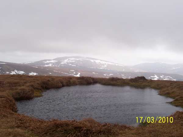
Picture: Moanbane, left with Silsean to the right.
Moanbane in W Wicklow has a flat, boggy top which is home to a small lake. It, and the top nearby Silsean, overlook the Blessington Lakes with good views also over to Mullaghcleevaun and S to the Table Mt. Area. They are also walked as part of the Glenbride circuit.
W. Park in Ballyknockan or at the picnic site B'Knock Bus (O01069 07313). Walk thru the village, turn left and aim for the forest corner A (O00710 06741). Keep the forest on your right and after about 700m head in and out of it on an obvious track, exiting at B (O01062 05658) before heading up steep, grassy slopes to the summit of S from where it's an easy walk over to M. Allow 2hrs
N. Park at BNulta Gp (O04387 10862) and head up the wide track to Black Hill. Continue to Billy Byrne's Gap C (O04330 06762), keeping to high ground. From here it's a short, easy rise to M. Allow 1.5hrs
SE. Park at GlBride Ln (O02834 03625) and go up via forest tracks until you meet a circular turning area. The track narrows here and soon a fence with access to open countryside appears - now it's an easy walk on improving terrain to the top of S and then a quick transit over to M. Allow 90 mins.
SE. A slightly shorter hike starts up the road at GlBride Lge (O03671 04203). Hop a fence and head up thru the small but pleasant wood before exiting into the gully that will take you on good ground close to the summit of S.
Seek permission if parking near the houses at road's end or if using the valley to the NE of here.
Notable tracks incl track/3388, track/4413 and for 2 cars track/1707.
From Silsean its a short hop accross to Moanbane. There is evidence of quadbike/scrambler activity in the area. The going can be very soft in places and in particular in the saddle between Silsean and Moanbane where there is a virtual marsh to cross. The reascent to Moanbane from Silsean is not taxing in the slightest and along the way great views accross Blessington and the reservoirs are on offer.
As discussed previously on this website there is no clear summit cairn or marker but judging by GPS readings the little pond is indeed the most likely candidate. This pond is not marked on sheet 56. Mullaghcleevaun can be tackled from Moanbane but I had other summits in mind to bag and decided to return to the car. From Moanbane I took a bearing for one of the streams feeding into the Ballinagee River. The descent from Moanbane to the head of the stream is not as knree jerking as it may appear. When I reached the location of the stream it was infact dried up but the river bed was clearly visible and I simply follwed this down to the where it forks with the Ballinagee River itself at D (O045 053). I came upon two seperate large herds of deer (perhaps 13-16 deer in each) as I approached the fork in the river, and judging by their reactions they are not used to seeing people pass this way. The valley below Billy Byrnes Gap is in itself a fine palce to be, and I decided to take lunch at the river side.
From this fork in the river a faint track or indeed number of tracks are evident which all eventually lead onto one main stone/gravel track which seems to be used by local farmers to herd and feed sheep and cattle. This track brought me right around the spur of Silsean and directly into the farm houses at the end of the road E (O038 043). From here the road can be followed back to the car with views over the Ballinagee river valley on your left hand side. All in all a nice little loop albeit very short. 10.1Km in total over 3.5hours. For me the day was not over yet as I headed for Sorrel Hill and Lugnagun. Linkback: mountainviews.ie/summit/107/comment/4518/
Read Less
Read More
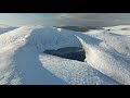
Small pool at the top.
by csd
23 Jun 2013
Poor visibility today made finding the actual summit of Moanbane quite tricky. There's nothing obvious in the vicinity of the grid ref in the database, so I've entered a small pool 705 m elevation as the summit on my GPS. The pool isn't marked on the Harvey map, but it appears to be just where the summit is marked. Nice views over to the Barnacullian ridge on the way up, but alas all was obscured by low clouds long before I reached the summit. Linkback: mountainviews.ie/summit/107/comment/527/
Read Less
Read More
Picture: The head on a frothy pint?
White bog and cottongrass.
by padodes
23 Jun 2013
On a recent visit to Moanbane, I found the little pond on top had frozen over and the lingering snow that had fallen on it had risen into a puffy meringue or soufflé, or a bowl of whipped cream, or the head of a frothy pint – wherever your taste buds take you (see photo, with snow-ribbed Mullaghcleevaun in the left background).
The name Moanbane (Móin Bhán: white bog) must surely be derived from the carpet of bog cotton (cottongrass) that covers this and the surrounding hills in early summer. Seen from the far side of Blessington Lake in that season, the domes of Silsean (another luminous name), Moanbane and even unpromising Black Hill can look snow-white in the sunshine.
A bog slide was recorded somewhere on the slopes of Moanbane in 1938. Even today, dropping down to the lower reaches on the western side, you will now and again come across a few ominous, gaping holes in the vegetation, sometimes with the throaty gurgle of water below. One is left calculating the uncomfortable odds against another part of this blanket of bog shearing off some black day under the heavy stomp of one’s all-too-confident boots. Linkback: mountainviews.ie/summit/107/comment/3605/
Read Less
Read More
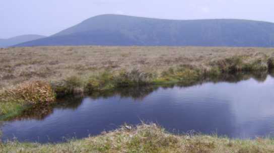
Picture: Pool on Moanbane summit, Mullaghcleevaun in the background.
kaybee on Moanbane
by kaybee
11 May 2008
Climbed Moanbane from Black Hill on a lovely summer afternoon, cloudy but very warm. Met nobody else walking, but the tranquility of the hills was interrupted by a group of 6 or 8 scrambler bikers who were buzzing about all over Moanbane, Mullaghcleevaun and Black Hill. As previously proposed, I am in agreement that the pool at the summit is good to mark the high point and here's how it looked on this fine summer's day.... Linkback: mountainviews.ie/summit/107/comment/3097/
Read Less
Read More
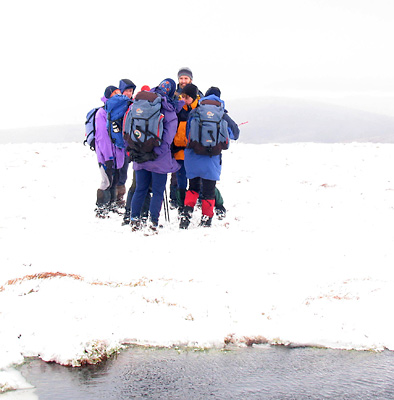
Picture: Moanbane pond.
simon3 on Moanbane
by simon3
17 Mar 2009
There's no distinct top but, as csd says, it seems to be somewhere near this pond.
I was up here on a fine summer day to find dragonflies cavorting. Not so the cold windy January day of this picture. The group were huddled together for warmth, just willing me to finish fiddling with the camera.
Use of MountainViews is governed by conditions and a privacy policy.
Read general information about the site. Opinions in material here are not necessarily endorsed by MountainViews.
Hillwalking is a risk sport. Information in comments, walks, shared GPS tracks or about starting places may
not be accurate for example as regards safety or access permission. You are responsible for your safety and your permission to walk.
See the credits and list definitions.


 Our Facebook page.