This website uses cookies, which are small text files that the website puts on your device to facilitate operation. Cookies help us provide a better service to you. They are used to track general user traffic information and to help the website function properly.
Feature count in area: 115, by county: Wicklow: 108, Kildare: 4, Wexford: 2, Carlow: 3, of which 1 is in both Wexford and Wicklow, of which 1 is in both Carlow and Wicklow,
OSI/LPS Maps: 28B, 55, 56, 61, 62, AWW, EW-DM, EW-LG, EW-WE, EW-WS
Highest Place: Lugnaquilla 924.7m
Starting Places (205) in area Wicklow: 1916 Memorial Car Park, Aghavannagh Ow Bridge, Aghowle Wood, Altidore Wood Entrance, Annacurra National School, Annalecka Bridge, Asbawn Brook L8350, Aughrim National School, Ballard Road, Ballinabarny Gap, Ballinagappoge Bridge Layby, Ballinagappoge Mountain Hairpin, Ballinagore, Ballinahinch Wood, Ballinastoe MBT CP, Ballinastraw South, Ballineddan Upr Fork, Ballinfoyle Upr Cross, Ballycoog, Ballycreen Brook Bridge, Ballycumber, Ballycumber Bridge, Ballycumber Lane, Ballycumber Wicklow Way, Ballylerane, Ballylow Bridge, Ballylusk Quarry, Ballymanus Lane, Ballymoyle Shooting Lodge, Ballynultagh Gap, Ballynultagh Lane, Ballyreagh Wood, Ballyross Forest, Ballysmuttan Long Stone, Baravore, Barnbawn South, Barranisky North, Barranisky West, Bohilla Land Roundabout, Bohilla Lane Mid, Boranaraltry Bridge, Bray Harbour, Brewel West, Brittas Bay North CP, Buckroney Sand Dunes CP, Bus Terminus, Camera Hill Track Cross, Castletimon Wood North, Clara Vale, Clone House Road, Clonegal, Cloon Wood Cp, Coate Bridge, Coolballintaggart Ledge, Coolbawn House Lane, Cransillagh Brook , Crone Wood CP, Crossbridge, Crossoona Rath, Cummer Wood South, Curtlestown Wood CP, Deputy's Pass CP, Derralossary Church, Derry River Bridge, Devil's Glen CP, Devil's Glen Wood, Djouce Wood Calary, Djouce Wood Lake, Djouce Wood Long Hill, Donard, Donnelly's Lane Car Sales, Drumgoff Forest, Dunranhill North, Dunranhill SE, Dunranhill South, Dwyer McAllister Cottage CP, Enniskerry, Fentons Pub, Fitzsimons Park GAA, unuseableFlemings Footbridge Glen Rd, Gap Pub, Gap Road, Glen Beach CP, Glen of the Downs CP, Glenbride Lane, Glenbride Lodge, Glencree Reconciliation, Glendalough, Glenealy GAA, Glenmacnass Tonelagee CP, Glenmalure Hostel, Glenmalure Lodge, Glenmalure Waterfall, Glenview Hotel, Gowle House, Great Sugar Loaf CP, Grove Bar, Heffernans Well Wood, Hill View, Hollywood Glen, JB Malone CP, Johnnie Fox Pub, Keadeen NE trail, Keadeen Trailhead, Kevins Way Footbridge, Kilbride Army Camp Entrance, Kilcandra South, Kilcommon View, Killalongford Wood, Kilmacrea Cross Roads, Kilranelagh House Gate, Kilruddery Car Park, Kilruddery Cottages, Kings River, Kippure Bridge, Kippure Estate, Kippure Transmitter Gate, Knickeen Cross, Knocknaboley Lane Leeraghs Bog, Knocknaboley Lane Stone Cottage, Knockrath Little, Knockree west, Kyle Loop North, Lackan Wood S, Lake Dr Fraughan Brook, Lake Drive, Lake Park Cross, Lake View Pub, Laragh Free Car Park, Laragh NSch, Lead Mines CP, Liffey Bridge, Liffey Head Bridge, Lough Bray Lower, Lough Bray Upper, Lough Tay North Viewing Point, Lough Tay Wicklow Way CP, Luglass Lane L97561, Lugnagun Track, Macreddin Village, Mangans Lane, Military Road Carrigshouk Hill, Military Road Inchavore River Nth, Military Road Inchavore River Sth, Military Road NW Lough Tay, Military Road Ballyboy Bridge, Military Road Cloghoge Brook, Military Road Croaghanmoira, Military Road Fananierin, Military Road LaraghWicklow Way, Military Road Slieve Maan, Monspolien Bridge, Moortown House, Mountain Rescue HQ, Muskeagh Little Wood, Nahanagan Lough NE, Novara Avenue, Bray, Oiltiagh Brook Knickeen, Old Bridge Cross, Old Bridge Scouts , Old Wicklow Way entrance, Paddock Hill SE, Pier Gates CP, Powerscourt Waterfall CP, Putland Road, Quintagh East, Raheen Park CP, Raheenleagh East, Railway Walk CP, Rathdrum Railway Station, Rednagh Wood, Rocky Valley, Roundwood, Sally Gap, Sally Gap N, Seefin Trailhead, Seskin SE, Shankill Tributary Bridge, Shay Elliott, Sheepshanks Bridge, Shillelagh, Slievecorragh Track, Slievefoore South, Sraghoe Brook, St John's Church, St Kevins Chair, St Kevins Church, St Kevins Way R756, Stone Circle Bridge, Stookeen South, Stranahely Wood, Stranakelly Cross Roads, Tallyho, Templeboden, Tithewer, Tomcoyle L, Tomriland Wood, Toor Brook, Trooperstown Hill Access, Turlough Hill CP, Upper Lake CP, Vallymount GAA CP, Vartry Reservoir Upper, Zellers Pub
Summits & other features in area Wicklow: Cen: Glendalough North: Brockagh Mountain 556.9m, Brockagh Mountain NW Top 549.5m, Brockagh Mountain SE Top 471.7m, Camaderry East Top 677.3m, Camaderry Mountain 698.6m, Conavalla 734m, Tomaneena 682.4m Cen: Glendalough South: Carriglineen Mountain 456.6m, Cullentragh Mountain 510m, Derrybawn Mountain 476.1m, Kirikee Mountain 474.5m, Lugduff 653.2m, Lugduff SE Top 638m, Mullacor 660.7m, Trooperstown Hill 430m N Cen: Tonelagee: Carrignagunneen 561m, Fair Mountain 571.2m, Stoney Top 713.7m, Tonelagee 815.8m, Tonelagee E Top 668m, Tonelagee South-East Top 545.8m NE: Bray & Kilmacanogue: Bray Head Hill 238.9m, Carrigoona Commons East 242m, Downs Hill 372.9m, Great Sugar Loaf 501.2m, Little Sugar Loaf 342.4m NE: Djouce: Djouce 725.5m, Knockree 342.1m, Maulin 570m, Tonduff 642m, Tonduff East Top 593m, War Hill 684.8m, White Hill 631.1m NE: Fancy: Ballinafunshoge 480m, Kanturk 527.4m, Knocknacloghoge 532.4m, Luggala 593.3m, Robber's Pass Hill 508.9m, Scarr 640m, Scarr North-West Top 559.8m, Sleamaine 430m NE: Vartry: Ballinacorbeg 336m, Ballycurry 301m, Dunranhill 342m, Mount Kennedy 365.9m NW: Blessington: Carrigleitrim 408m, Lugnagun 446.2m, Slieveroe 332m, Sorrel Hill 599.5m NW: Mullaghcleevaun: Black Hill 602.2m, Carrigshouk 572.5m, Carrigvore 682.4m, Duff Hill 720.8m, Gravale 719m, Moanbane 703m, Mullaghcleevaun 846.7m, Mullaghcleevaun East Top 796m, Silsean 698m S: Aughrim Hills: Cushbawn 400m, Killeagh 249m, Moneyteige North 427m, Preban Hill 389m S: Croaghanmoira: Ballinacor Mountain 529.3m, Ballycurragh Hill 536m, Ballyteige 447m, Carrickashane Mountain 508m, Croaghanmoira 662.3m, Croaghanmoira North Top 579.5m, Fananierin 426m, Slieve Maan 547.8m, Slieve Maan North Top 546.1m S: Croghan Kinsella: Annagh Hill 454m, Croghan Kinsella 606m, Croghan Kinsella East Top 562.1m, Slievefoore 414m S: Shillelagh Hills: Lakeen 357m, Monaughrim 206m, Seskin 344m, Stookeen 420m S: Tinahely Hills: Ballycumber Hill 429.7m, Eagle Hill 296m, Muskeagh Hill 398.2m SE: Wicklow South East: Ballinastraw 284m, Ballyguile Hill 188m, Barranisky 280m, Carrick Mountain 381m, Collon Hill 238m, Kilnamanagh Hill 217m, Westaston Hill 270m W: Baltinglass: Ballyhook Hill 288m, Baltinglass Hill 382m, Carrig Mountain 571m, Carrigeen Hill 298m, Cloghnagaune 385m, Corballis Hill 258m, Keadeen Mountain 653m, Spinans Hill 409m, Spinans Hill SE Top 400m, Tinoran Hill 312m W: Cen Lugnaquilla: Ballineddan Mountain 652.3m, Benleagh 689m, Camenabologue 758m, Camenabologue SE Top 663m, Cloghernagh 800m, Corrigasleggaun 794.6m, Lugnaquilla 924.7m, Slievemaan 759.7m W: Donard: Brewel Hill 222m, Church Mountain 544m, Corriebracks 531m, Lobawn 636m, Slievecorragh 418m, Sugarloaf 552m, Table Mountain 701.7m, Table Mountain West Top 563m
Note: this list of places may include island features such as summits, but not
islands as such.
Dunranhill, 342mHill
Place Rating ..
, Wicklow County in Leinster province, in Binnion Lists, Dunranhill is the 1073th highest place in Ireland.
Grid Reference O26198 02253,
OS 1:50k mapsheet 56 Place visited by: 34members, recently by: hibby, Kaszmirek78, Colin Murphy, madfrankie, Ansarlodge, Dee68, monisr, Beti13, Grumbler, loftyobrien, emac, abcd, briankelly, eugeneryan959, conormcbandon
I visited this place: NO (You need to be a logged-in member for this.)
Short or GPS IDs, 6 char: Dnrnhl, 10 char: Dunranhill Linkback: https://mountainviews.ie/summit/1101/
Gallery for Dunranhill and surrounds
Summary
for Dunranhill :
A walk in the woods
Summary created by Colin Murphy
2023-10-24 14:35:16
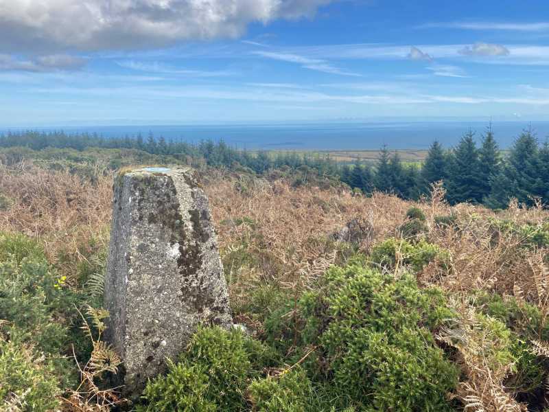
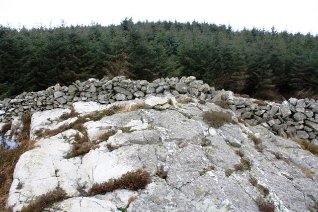
Picture: Summit area
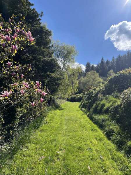
There have been access issues with this hill in the past, as it is a private forestry plantation, so if possible, if there is someone around associated with the forest, ask permission before ascending. One possible starting point is from A (O025 552) 02674, where there is just room to park on a grassy verge by the side of the road. Head up a grass-covered track behind a house for a few hundred metres, cross a gate, and continue to two further gates. Cross the gate on the right into a small clearing, with a high wall of furze and brambles ahead. There is a narrow gap that allows access through this onto a good forest track. Turn right, and then right again at B (O25800 02634) and follow the track around the hillside for about 1.5km, passing within 20m of the trig pillar, which is half-hidden among low shrubs, heather and some gorse. Extensive views of Wicklow coast.
There is good information about the recent history of this forest and its transition to continuous cover forestry at: https://www.teagasc.ie/media/website/crops/forestry/research/Continuous-Cover-Forestry-at-Dunranhill-Forest-2.pdf This is a useful (and very interesting) read for anyone planning to visit this summit.
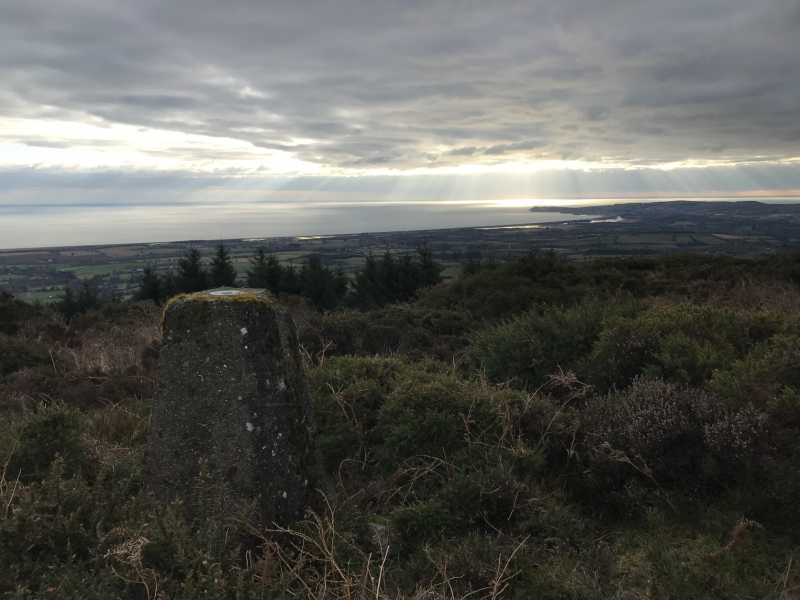
We followed the excellent directions set out by Colin Murphy to get to the summit. Almost the entire walk was on pleasant forest tracks and paths, firm and dry underfoot. The final approach from the path to the trig point marker at the summit is about 60 metres over heather and fraughan bushes, with the immediate summit area getting a bit overgrown with gorse. The views of hills and coastline are astonishing. We encountered a lot of deer.
Returning from the summit we decided to continue around the loop which made for a very pleasant walk back to the starting point.
Regarding access and permissions, we passed a number of "no trespassing" signs. We did not encounter anyone on a Sunday morning at the end of April. Linkback: mountainviews.ie/summit/1101/comment/24186/
Read Less
Read More
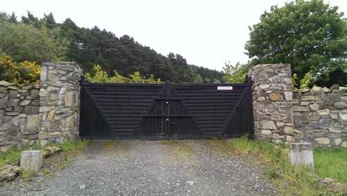
Picture: The Elusive Entrance.
Private Forest.
by sandman
30 May 2014
The summit of this hill is located in a private forest Dunranhill Forest not Coillte accessed (with permission) at its entrance located at DnHill N (O25879 02887) which allows a very easy accent over forest roads to within meters of the trig. Linkback: mountainviews.ie/summit/1101/comment/16083/
Read Less
Read More
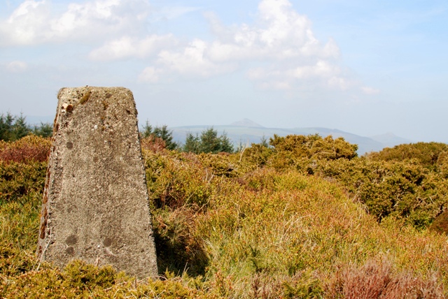
Picture: Dunran Trig Hard or easy you choose!
Resist the call to crawl
by eamonoc
16 Apr 2014
Having read the others comments about Dunran Hill, and the fact that on a previous occasion I also drove around looking for access to this Hill. I started at DnHill SE (O24609 00899) was able to park car back in off road beside a farm entrance track. Across the road crossed a rusty gate and followed a short farm track into a very green fielld with some sheep grazing in the upper reaches went uphill to right hand corner of field and easily accessed the high ground beyond called Carrignamuck upper on OS sheet 56. Headed uphill to the corner of a forest at C (O251 014). I followed tha edge of this forest away to the righthand corner then keeping the edge of the forest on my left went steeply uphill to D (O255 018). Now on high heathery ground I headed in an easterly direction to Wicklores point E (E (O26032 02021)). There is a large stone wall here which I easily crossed at a suitable low point and onto a large well made forest track. Looking at the dense forest in front of me and not relishing the thought of a painful 100mt crawl through, I headed downhill to the left on this track after about 100mts I followed a track to the right uphill through the trees and came out at summit area with no scratches sore knees or the like, The trig point is just off to the right of the high point of this track among some low sized gorse bushes. Great views in all direction from here followd upward route back to car. I am not sure if summit area is private and on Dunran Demense land. There were no warning signs about access issues at the large stone wall. Linkback: mountainviews.ie/summit/1101/comment/16012/
Read Less
Read More
Picture: The summit lies beyond the dense forest
Difficult access route
by wicklore
12 Apr 2014
When researching the new 100m prominence list for MountainViews in 2012 I eventually came to Dunrahill. Despite driving around it twice I couldn't find a public access route up. I ended up in a a small boreen road to the south where a passing local man pointed me to a farm gate he said I could use to head up at DnHill S (O25908 01155). The gate was locked and there was a track beyond it. After about 300 metres I left the track and headed uphill to the left. I eventually reached a rocky plateau with a dense forest beyond. I entered the forest at E (O26032 02021) and I found it very difficult to get through. Dense prickly twigs poked at me and rough ground with a few rocky crags and drops had to be negotiated. There was some crawling and sliding under the densest areas of forest and wet ground and after a few hundred metres I emerged spluttering onto a forest track near the summit at F (O026 022) 02098. The summit area has a network of tracks and is clear of trees. I had to wonder where the entrance to these tracks began on the public road below as I couldn't find it. There is a trig pillar at the summit at G (O26200 02256). Fine views south to Wicklow Town and out to the Irish Sea and north to the two Sugarloafs, as well as to nearby Ballycurry. I returned by the same route generally, although I covered some new ground on the descent for variety Linkback: mountainviews.ie/summit/1101/comment/15988/
Read Less
Read More
Picture: View towards Wicklow Harbour
Great views from a tough little hill
by srr45
5 Feb 2018
Tricky summit to reach. I found path all the way just short of the summit by approaching from the NW however this is private forest and permission should be granted before hand. All in all a 300m ascent from that end and 6km round trip from the public road. Linkback: mountainviews.ie/summit/1101/comment/19847/
Use of MountainViews is governed by conditions and a privacy policy.
Read general information about the site. Opinions in material here are not necessarily endorsed by MountainViews.
Hillwalking is a risk sport. Information in comments, walks, shared GPS tracks or about starting places may
not be accurate for example as regards safety or access permission. You are responsible for your safety and your permission to walk.
See the credits and list definitions.


 Our Facebook page.