This website uses cookies, which are small text files that the website puts on your device to facilitate operation. Cookies help us provide a better service to you. They are used to track general user traffic information and to help the website function properly.
Feature count in area: 24, all in Donegal,
OSI/LPS Maps: 10
Highest Place: Slieve League 596.4m
Starting Places (1) in area Donegal SW: Port Pier
Summits & other features in area Donegal SW: Maum 325m N: Sliabh Tuaidh: Tormore Island South 94m, Tormore Island North 139m, Crockuna 400m, Slievetooey 511m, Slievetooey Far West Top 460m, Slievetooey West Top 472m NE: Glengesh: Balbane Hill 472m, Glengesh Hill 390m, Common Mountain 499.7m, Crocknapeast 497m, Croaghavehy 372m, Mulmosog Mountain 351m, Mulnanaff 475m NW: Glencolmkille: Croaghacullion 374m, Croaghloughdivna 310m S: Killybegs Hills: Croaghacullin 405m, Croaghmuckros 275m, Crownarad 493m, Crownarad SW Top 471m SW: Slieve League: Crockrawer 435.2m, Leahan 427m, Slieve League 596.4m, Slieve League SE Top 576.7m
Note: this list of places may include island features such as summits, but not
islands as such.
Mulnanaff, 475mHill Maol na nDamh A name in Irish,
Place Rating ..
(Ir. Maol na nDamh [OSI], 'bald hill of the stags'), Donegal County in Ulster province, in Carn Lists, Maol na nDamh is the 650th highest place in Ireland.
Grid Reference G67700 82736,
OS 1:50k mapsheet 10 Place visited by: 19members, recently by: Colin Murphy, markmjcampion, eamonoc, PPruzina, LorraineG60, MichaelG55, Fergalh, PPruz, madfrankie, Garmin, liz50, Geo, millsd1, sandman, juliewoods
I visited this place: NO (You need to be a logged-in member for this.)
Longitude: -8.50163, Latitude: 54.691619, Easting: 167700, Northing: 382736,
Prominence: 57m, Isolation: 1.9km ITM: 567658 882726 Bedrock type: Banded semi-pelitic & psammitic schist, (Termon Formation) Notes on name: There is another hill of the same name in NW Donegal, but there it is anglicised Moylenanav.
Short or GPS IDs, 6 char: Mlnnf, 10 char: Mulnanaff Linkback: https://mountainviews.ie/summit/532/
Gallery for Mulnanaff (Maol na nDamh) and surrounds
Summary
for Mulnanaff (Maol na nDamh):
Longish walk up windfarm road.
Summary created by Colin Murphy
2024-04-29 13:52:38
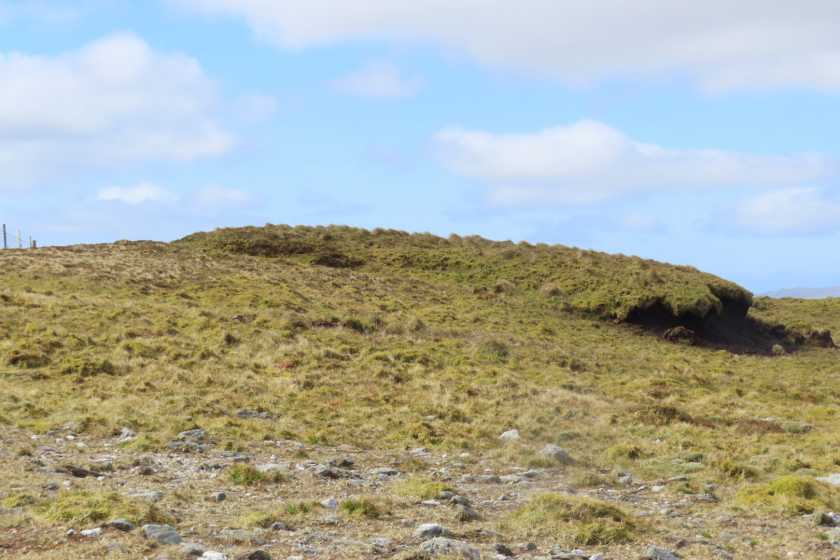
Picture: Grassy bump marks high point
Mulnanaff is reached via a longish walk of about 10km return, mostly along windfarm tracks. There is parking for a couple of cars at a forestry entrance at A (G70138 81131). Cross over gate and walk up as far as a T-junction then turn right. Continue along gently rising gravel track to B (G68298 82971). At this point you are at 440m elevation. Leave track turning west onto open hillside, dropping down to a col about 20m below. You will see a fence winding up the slope and curving around to the south. Follow this for about 700m, which will take you to the high point - a grassy/heathery mound on the west side of the fence with a couple of stones on top. You can combine this with a walk to Crocknapeast - just 1.5km away, if you wish. Return same route.
From Balbane Hill IC (G69550 82882) there is a short drop to the windfarm service road which provides easy walking for part of the distance to the target mountain. Be careful as you approach the road as the ground immediately to it's side has not settled yet and you're likely to sink in well above the ankles. Simply follow the road up to the last windturbine and then take the relatively short drop onto marshy ground before the ascent (damp at first) to the undefined summit area. There are a number of raised areas vying for the honour of summit. Picture shows the one the GPS favours (taken a short distance away on descent north towards Crow River). A word to the wise I took a bearing directly to what appeared on the map to be a track running along the outer edge of the forest west of Crowbane ID (G677 841) with a view to taking it down to the Carrick to Adara road. Needless to say there was no track and it was quite wet near the fence. If following this route I'd be inclined to maintain a little height for as long as possible. Linkback: mountainviews.ie/summit/532/comment/3795/
Read Less
Read More
Alternative access point
by MichaelG55
9 Jul 2020
With a windfarm,6 turbines, now built between Mulnanaff and Balbane Hill access to Mulnanaff is much easier now. Parking available at forestry gate at E (G701 811) and a easy walk in. Linkback: mountainviews.ie/summit/532/comment/20809/
Use of MountainViews is governed by conditions and a privacy policy.
Read general information about the site. Opinions in material here are not necessarily endorsed by MountainViews.
Hillwalking is a risk sport. Information in comments, walks, shared GPS tracks or about starting places may
not be accurate for example as regards safety or access permission. You are responsible for your safety and your permission to walk.
See the credits and list definitions.


 Our Facebook page.