Welcome to MountainViews
If you want to use the website often please enrol (quick and free) at top right.
If you want to use the website often please enrol (quick and free) at top right.
Overview

For more map options click on any overview map area or any detail map feature.
Detail Map Features
Showing 12 items:
Common Mountain 499.7m, Crocknapeast 497m, Mulnanaff 475m, Balbane Hill 472m,
4652, 16km
5078, 14km
3887, 9km
4793, 9km
5015, 6km
2603, 6km
3536, 4km
3537, 3km
Common Mountain 499.7m, Crocknapeast 497m, Mulnanaff 475m, Balbane Hill 472m,
Tracks:
Find Suggested Walks
Find hill, mountain, island, coastal feature.
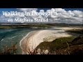
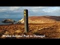
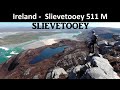
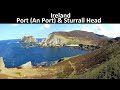
Videos
Recent Contributions
 Get Notifications
Get Notifications
Knocknagullion: Relatively challenging climb with great views.
 Collaborative entry
Tough enough Carn with very fine views
 Colin Murphy
Nowen Hill Far West Top: Previous access issue to this simple stroll seems to ha
 Colin Murphy
Good tracks to two Carns.
 Colin Murphy
Crott Mountain, near Croagh Patrick, now demo
 simon3
Minaun: Towards Keem
 magnumpig
Saggart Hill: Masts and prehistoric tombs
 hibby
hibby
A visit to Tievummera via its South East spur.
 simon3
Cupidstown Hill: 5 minutes walk to the top of Kildare
 hibby
hibby
Croagh Patrick's ridge to the east, visited from the south.
Tievummera Highpoint: Undistinguished highpoint of spectacular Sheefry scarp.
 Collaborative entry
Tievummera Trig: Bump with trig pillar on long scarp with steep slope to the nor
 Collaborative entry
Conditions and Info
Use of MountainViews is governed by conditions and a privacy policy.
Read general information about the site.
Opinions in material here are not necessarily endorsed by MountainViews.
Hillwalking is a risk sport. Information in comments, walks, shared GPS tracks or about starting places may not be accurate for example as regards safety or access permission. You are responsible for your safety and your permission to walk.
See the credits and list definitions.
 Visit our Facebook page.
Video display
Donegal SW
Area NE: Glengesh Subarea
Place count in area: 24,
OSI/LPS Maps: 10
Highest place: Slieve League, 596.4m
Maximum height for area: 596.4 metres,
Maximum prominence for area: 470 metres,
Places in area Donegal SW:
Maum 325m
N: Sliabh Tuaidh:Tormore Island South 94mTormore Island North 139mCrockuna 400mSlievetooey 511mSlievetooey Far West Top 460mSlievetooey West Top 472m
NE: Glengesh:Balbane Hill 472mGlengesh Hill 390mCommon Mountain 499.7mCrocknapeast 497mCroaghavehy 372mMulmosog Mountain 351mMulnanaff 475m
NW: Glencolmkille:Croaghacullion 374mCroaghloughdivna 310m
S: Killybegs Hills:Croaghacullin 405mCroaghmuckros 275mCrownarad 493mCrownarad SW Top 471m
SW: Slieve League:Crockrawer 435.2mLeahan 427mSlieve League 596.4mSlieve League SE Top 576.7m
Note: this list of places includes island features such as summits, but not islands as such.
Highest place:
Slieve League, 596.4mPlaces in area Donegal SW:
Maum 325mN: Sliabh Tuaidh:
Tormore Island South 94mTormore Island North 139mCrockuna 400mSlievetooey 511mSlievetooey Far West Top 460mSlievetooey West Top 472mNE: Glengesh:
Balbane Hill 472mGlengesh Hill 390mCommon Mountain 499.7mCrocknapeast 497mCroaghavehy 372mMulmosog Mountain 351mMulnanaff 475mNW: Glencolmkille:
Croaghacullion 374mCroaghloughdivna 310mS: Killybegs Hills:
Croaghacullin 405mCroaghmuckros 275mCrownarad 493mCrownarad SW Top 471mSW: Slieve League:
Crockrawer 435.2mLeahan 427mSlieve League 596.4mSlieve League SE Top 576.7mNote: this list of places includes island features such as summits, but not islands as such.

Bedrock type: Banded semi-pelitic & psammitic schist, (Termon Formation)
This peak is located on the watershed between Mulnanaff and Common Mountain, and on the boundary between the townlands of Crowbane and Tieveskeelta. Crocknapeast is the 578th highest place in Ireland.
Linkback: https://mountainviews.ie/summit/465/
COMMENTS for Crocknapeast (Cnoc na Péiste) 1 of 1  Follow this place's comments

|
|
|
|
||
| MountainViews.ie, a Hill-walking Website for the island of Ireland. 2400 Summiteers, 1480 Contributors, maintainer of lists: Arderins, Vandeleur-Lynams, Highest Hundred, County Highpoints etc | |||