Members and Supporters, the MountainViews Committee requests your help to meet the costs of the website and of other activities such as insured events or publications.
Feature count in area: 115, by county: Wicklow: 108, Kildare: 4, Wexford: 2, Carlow: 3, of which 1 is in both Wexford and Wicklow, of which 1 is in both Carlow and Wicklow,
OSI/LPS Maps: 28B, 55, 56, 61, 62, AWW, EW-DM, EW-LG, EW-WE, EW-WS
Highest Place: Lugnaquilla 924.7m
Starting Places (205) in area Wicklow: 1916 Memorial Car Park, Aghavannagh Ow Bridge, Aghowle Wood, Altidore Wood Entrance, Annacurra National School, Annalecka Bridge, Asbawn Brook L8350, Aughrim National School, Ballard Road, Ballinabarny Gap, Ballinagappoge Bridge Layby, Ballinagappoge Mountain Hairpin, Ballinagore, Ballinahinch Wood, Ballinastoe MBT CP, Ballinastraw South, Ballineddan Upr Fork, Ballinfoyle Upr Cross, Ballycoog, Ballycreen Brook Bridge, Ballycumber, Ballycumber Bridge, Ballycumber Lane, Ballycumber Wicklow Way, Ballylerane, Ballylow Bridge, Ballylusk Quarry, Ballymanus Lane, Ballymoyle Shooting Lodge, Ballynultagh Gap, Ballynultagh Lane, Ballyreagh Wood, Ballyross Forest, Ballysmuttan Long Stone, Baravore, Barnbawn South, Barranisky North, Barranisky West, Bohilla Land Roundabout, Bohilla Lane Mid, Boranaraltry Bridge, Bray Harbour, Brewel West, Brittas Bay North CP, Buckroney Sand Dunes CP, Bus Terminus, Camera Hill Track Cross, Castletimon Wood North, Clara Vale, Clone House Road, Clonegal, Cloon Wood Cp, Coate Bridge, Coolballintaggart Ledge, Coolbawn House Lane, Cransillagh Brook , Crone Wood CP, Crossbridge, Crossoona Rath, Cummer Wood South, Curtlestown Wood CP, Deputy's Pass CP, Derralossary Church, Derry River Bridge, Devil's Glen CP, Devil's Glen Wood, Djouce Wood Calary, Djouce Wood Lake, Djouce Wood Long Hill, Donard, Donnelly's Lane Car Sales, Drumgoff Forest, Dunranhill North, Dunranhill SE, Dunranhill South, Dwyer McAllister Cottage CP, Enniskerry, Fentons Pub, Fitzsimons Park GAA, unuseableFlemings Footbridge Glen Rd, Gap Pub, Gap Road, Glen Beach CP, Glen of the Downs CP, Glenbride Lane, Glenbride Lodge, Glencree Reconciliation, Glendalough, Glenealy GAA, Glenmacnass Tonelagee CP, Glenmalure Hostel, Glenmalure Lodge, Glenmalure Waterfall, Glenview Hotel, Gowle House, Great Sugar Loaf CP, Grove Bar, Heffernans Well Wood, Hill View, Hollywood Glen, JB Malone CP, Johnnie Fox Pub, Keadeen NE trail, Keadeen Trailhead, Kevins Way Footbridge, Kilbride Army Camp Entrance, Kilcandra South, Kilcommon View, Killalongford Wood, Kilmacrea Cross Roads, Kilranelagh House Gate, Kilruddery Car Park, Kilruddery Cottages, Kings River, Kippure Bridge, Kippure Estate, Kippure Transmitter Gate, Knickeen Cross, Knocknaboley Lane Leeraghs Bog, Knocknaboley Lane Stone Cottage, Knockrath Little, Knockree west, Kyle Loop North, Lackan Wood S, Lake Dr Fraughan Brook, Lake Drive, Lake Park Cross, Lake View Pub, Laragh Free Car Park, Laragh NSch, Lead Mines CP, Liffey Bridge, Liffey Head Bridge, Lough Bray Lower, Lough Bray Upper, Lough Tay North Viewing Point, Lough Tay Wicklow Way CP, Luglass Lane L97561, Lugnagun Track, Macreddin Village, Mangans Lane, Military Road Carrigshouk Hill, Military Road Inchavore River Nth, Military Road Inchavore River Sth, Military Road NW Lough Tay, Military Road Ballyboy Bridge, Military Road Cloghoge Brook, Military Road Croaghanmoira, Military Road Fananierin, Military Road LaraghWicklow Way, Military Road Slieve Maan, Monspolien Bridge, Moortown House, Mountain Rescue HQ, Muskeagh Little Wood, Nahanagan Lough NE, Novara Avenue, Bray, Oiltiagh Brook Knickeen, Old Bridge Cross, Old Bridge Scouts , Old Wicklow Way entrance, Paddock Hill SE, Pier Gates CP, Powerscourt Waterfall CP, Putland Road, Quintagh East, Raheen Park CP, Raheenleagh East, Railway Walk CP, Rathdrum Railway Station, Rednagh Wood, Rocky Valley, Roundwood, Sally Gap, Sally Gap N, Seefin Trailhead, Seskin SE, Shankill Tributary Bridge, Shay Elliott, Sheepshanks Bridge, Shillelagh, Slievecorragh Track, Slievefoore South, Sraghoe Brook, St John's Church, St Kevins Chair, St Kevins Church, St Kevins Way R756, Stone Circle Bridge, Stookeen South, Stranahely Wood, Stranakelly Cross Roads, Tallyho, Templeboden, Tithewer, Tomcoyle L, Tomriland Wood, Toor Brook, Trooperstown Hill Access, Turlough Hill CP, Upper Lake CP, Vallymount GAA CP, Vartry Reservoir Upper, Zellers Pub
Summits & other features in area Wicklow: Cen: Glendalough North: Brockagh Mountain 556.9m, Brockagh Mountain NW Top 549.5m, Brockagh Mountain SE Top 471.7m, Camaderry East Top 677.3m, Camaderry Mountain 698.6m, Conavalla 734m, Tomaneena 682.4m Cen: Glendalough South: Carriglineen Mountain 456.6m, Cullentragh Mountain 510m, Derrybawn Mountain 476.1m, Kirikee Mountain 474.5m, Lugduff 653.2m, Lugduff SE Top 638m, Mullacor 660.7m, Trooperstown Hill 430m N Cen: Tonelagee: Carrignagunneen 561m, Fair Mountain 571.2m, Stoney Top 713.7m, Tonelagee 815.8m, Tonelagee E Top 668m, Tonelagee South-East Top 545.8m NE: Bray & Kilmacanogue: Bray Head Hill 238.9m, Carrigoona Commons East 242m, Downs Hill 372.9m, Great Sugar Loaf 501.2m, Little Sugar Loaf 342.4m NE: Djouce: Djouce 725.5m, Knockree 342.1m, Maulin 570m, Tonduff 642m, Tonduff East Top 593m, War Hill 684.8m, White Hill 631.1m NE: Fancy: Ballinafunshoge 480m, Kanturk 527.4m, Knocknacloghoge 532.4m, Luggala 593.3m, Robber's Pass Hill 508.9m, Scarr 640m, Scarr North-West Top 559.8m, Sleamaine 430m NE: Vartry: Ballinacorbeg 336m, Ballycurry 301m, Dunranhill 342m, Mount Kennedy 365.9m NW: Blessington: Carrigleitrim 408m, Lugnagun 446.2m, Slieveroe 332m, Sorrel Hill 599.5m NW: Mullaghcleevaun: Black Hill 602.2m, Carrigshouk 572.5m, Carrigvore 682.4m, Duff Hill 720.8m, Gravale 719m, Moanbane 703m, Mullaghcleevaun 846.7m, Mullaghcleevaun East Top 796m, Silsean 698m S: Aughrim Hills: Cushbawn 400m, Killeagh 249m, Moneyteige North 427m, Preban Hill 389m S: Croaghanmoira: Ballinacor Mountain 529.3m, Ballycurragh Hill 536m, Ballyteige 447m, Carrickashane Mountain 508m, Croaghanmoira 662.3m, Croaghanmoira North Top 579.5m, Fananierin 426m, Slieve Maan 547.8m, Slieve Maan North Top 546.1m S: Croghan Kinsella: Annagh Hill 454m, Croghan Kinsella 606m, Croghan Kinsella East Top 562.1m, Slievefoore 414m S: Shillelagh Hills: Lakeen 357m, Monaughrim 206m, Seskin 344m, Stookeen 420m S: Tinahely Hills: Ballycumber Hill 429.7m, Eagle Hill 296m, Muskeagh Hill 398.2m SE: Wicklow South East: Ballinastraw 284m, Ballyguile Hill 188m, Barranisky 280m, Carrick Mountain 381m, Collon Hill 238m, Kilnamanagh Hill 217m, Westaston Hill 270m W: Baltinglass: Ballyhook Hill 288m, Baltinglass Hill 382m, Carrig Mountain 571m, Carrigeen Hill 298m, Cloghnagaune 385m, Corballis Hill 258m, Keadeen Mountain 653m, Spinans Hill 409m, Spinans Hill SE Top 400m, Tinoran Hill 312m W: Cen Lugnaquilla: Ballineddan Mountain 652.3m, Benleagh 689m, Camenabologue 758m, Camenabologue SE Top 663m, Cloghernagh 800m, Corrigasleggaun 794.6m, Lugnaquilla 924.7m, Slievemaan 759.7m W: Donard: Brewel Hill 222m, Church Mountain 544m, Corriebracks 531m, Lobawn 636m, Slievecorragh 418m, Sugarloaf 552m, Table Mountain 701.7m, Table Mountain West Top 563m
Note: this list of places may include island features such as summits, but not
islands as such.
Camenabologue SE Top, 663mMountain Céim na mBulóg (mullach thoir theas) A name in Irish,
Place Rating ..
For origin of name, see Camenabologue., Onickabhan, Wicklow County in Leinster province, in Arderin, Vandeleur-Lynam Lists, Camenabologue SE Top is the 174th highest place in Ireland.
Grid Reference T03665 95383,
OS 1:50k mapsheet 56 Place visited by: 443members, recently by: Hjonna, Courin, rhw, maoris, davidrenshaw, Prem, Carolineswalsh, ToughSoles, muddypaws, Sonyalaw, benjimann9, Alanjm, SeanPurcell, mdehantschutter, Magic
I visited this place: NO (You need to be a logged-in member for this.)
Longitude: -6.456709, Latitude: 52.999451, Easting: 303665, Northing: 195383,
Prominence: 38m, Isolation: 1.2km ITM: 703591 695417 Bedrock type: Fine-grained, muscovite-rich aplogranite, (Barravore Aplogranite) Notes on name: Previously Table Mtn SE Top in MV.
Short or GPS IDs, 6 char: CmnbSE, 10 char: CmnblgSETp Linkback: https://mountainviews.ie/summit/171/
Gallery for Camenabologue SE Top (Céim na mBulóg (mullach thoir theas)) and surrounds
Summary
for Camenabologue SE Top (Céim na mBulóg (mullach thoir theas)):
Unremarkable outlier of main Camenabologue summit
Summary created by wicklore, Colin Murphy
2019-10-06 13:39:01
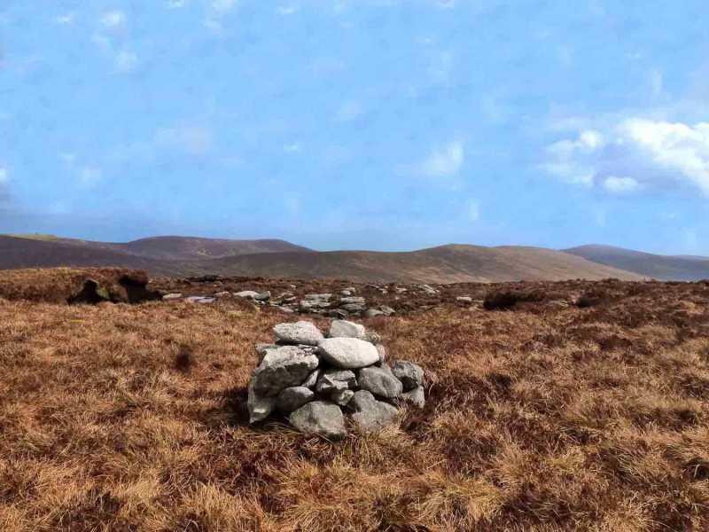
Picture: Summit cairn
Starting at the large carpark at B'vore (T06617 94163) in Glenmalure, cross the nearby footbridge.
Once across the ford, follow the good Coillte track for several kilometers higher into valley. After a track junction at A (T04476 95550), Camenabologue SE Top is on your left above the trees. The track continues ahead and you can find your own place to climb up to the summit. (There is forestry to contend with which is very dense and the terrain underfoot extremely irregular, and this route is quite difficult). Another option is to take a left at the track into Fraughan Rock Glen at B (T057 948). This splits after a bit, one trail leading into the glen, the other snaking back around and skirting Benleagh and Camenabologue SE Top. (The well surfaced track is not marked on the map). Continue until C (T044 953) where you will have relatively easy access to the open mountainside.
Alternatively continue on the track to reach the col between Table Mountain and Camenabologue at D (T02085 96698). From here it is a 10 minute ramble to the summit of Camenabologue, and a further 25 boggy minutes to the SE Top.
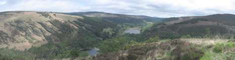
Views from Camenabologue SE Top are extensive, including the three highest Wicklow Mountains - Lugnaquilia, Tonelagee and Mullaghcleevaun - as well as the elusive Three Lakes (well two of them!), Turlough Hill and dozens of other Wicklow summits. Other than that, this summit is unremarkable.
Although I have walked in Wicklow for hrumphty years I can't recall trying the delights of this summit. There's many a well-worn and classic route that passes near it but not over it. My visit was occasioned by a howling March gale with shot-gun hail in sustained bursts. One thing you can say for this place is that there's little sign that anyone else climbs it either though quite a few have logged it as one of the places they have climbed.
The summit is marked by a small cairn on top of a peat-hag. Curiously there is another, larger cairn 150m to the SE of the summit. I would guess that on a good day you would get an interesting view down Glenmalure showing much of its length (the longest glacial valley in Ireland).
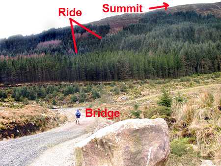
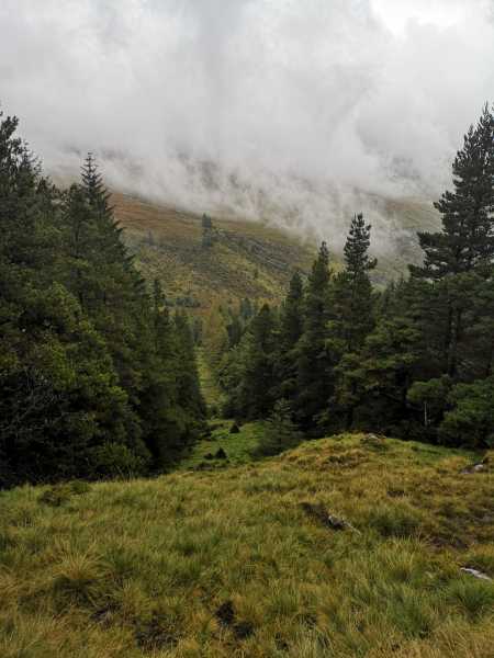
One way up is as follows. Start at the Boravore car park. Walk up the valley past the An Oige hostel, past Ben Leagh to find the newish forestry bridge which is a substantial masonry construction over the Avonbeg River at E (T04449 95585) around 2.8km from the Boravore carpark not shown on the OS map as of 2006. This is a useful bridge to know about incidentally because various routes can be constructed using it. Anyway from the bridge go south (possibly back the way you came), turn left at the first junction, then take the right fork, then at the next junction (at around F (T04491 95492)) find a ride (linear gap in the trees) leading SW up the Table SE Top. The ride is hard to see from the road but once you are on it, you will be in a moss covered avenue which broadens out into an unusual triangle of unplanted ground shown in the picture. Then just climb to the top across a most convex of slopes. (Of course, by the time you do this the trees may be all cut down and you will have clamber over clear felling.)
At the top there's various options for example towards Camenabologue or across a fine and very quiet valley to Ben Leagh. Linkback: mountainviews.ie/summit/171/comment/2642/
Read Less
Read More
Picture: The forest ride not showing how steep it is
Never again
by ewen
24 Sep 2019
Went up via the Forest ride from the table track. Put it this way, it may have been the conditions, it may have been the waterlogged steep ride but this is one hill I am never going near again. The second cairn is much more impressive than the actual top but why is it there? Linkback: mountainviews.ie/summit/171/comment/20657/
Read Less
Read More
Take care in the col
by Bunsen7
30 Apr 2017
Descended to the col from camenabologue on 30 Apr 2017. It was a very wet day up there, the SE top was final objective. The col is NW of this summit.
Sorry to say that on this day, with bad weather, the col thwarted my ascent. Visibility was very poor, but the col was impassable. Deep bog pools 10-15 metres wide in the vicinity of G (T033 954).
I got a better view for a matter of seconds as I headed back, but I think you would need to go well over to the east side of the col to pass it. There is much more water around than the maps suggest.
The col between Camenabologue SE Top and Camenabologue proper, that is. It's easier now because much of the forestry has been removed from the slopes hereabouts. Mind you, the slope is steep in places and the going is soggy and treacherous. You need to have your wits about you, but with care should get down and save yourself and your boots a bit of mileage on the track back to Baravore carpark. Linkback: mountainviews.ie/summit/171/comment/20886/
Read Less
Read More
pazapas on Camenabologue SE Top
by pazapas
13 Aug 2006
19/05/04: the first time I walked in Glendalough Mountains was in 2000, I found a group of nearly thirty deers. This year there was no wild animal to see. Walking in this area is very easy but forget it if you want to hike alone. (Bigger picture at http://emeraldisland.free.fr) Linkback: mountainviews.ie/summit/171/comment/1228/
Use of MountainViews is governed by conditions and a privacy policy.
Read general information about the site. Opinions in material here are not necessarily endorsed by MountainViews.
Hillwalking is a risk sport. Information in comments, walks, shared GPS tracks or about starting places may
not be accurate for example as regards safety or access permission. You are responsible for your safety and your permission to walk.
See the credits and list definitions.


 Our Facebook page.