This website uses cookies, which are small text files that the website puts on your device to facilitate operation. Cookies help us provide a better service to you. They are used to track general user traffic information and to help the website function properly.
Feature count in area: 115, by county: Wicklow: 108, Kildare: 4, Wexford: 2, Carlow: 3, of which 1 is in both Wexford and Wicklow, of which 1 is in both Carlow and Wicklow,
OSI/LPS Maps: 28B, 55, 56, 61, 62, AWW, EW-DM, EW-LG, EW-WE, EW-WS
Highest Place: Lugnaquilla 924.7m
Starting Places (205) in area Wicklow: 1916 Memorial Car Park, Aghavannagh Ow Bridge, Aghowle Wood, Altidore Wood Entrance, Annacurra National School, Annalecka Bridge, Asbawn Brook L8350, Aughrim National School, Ballard Road, Ballinabarny Gap, Ballinagappoge Bridge Layby, Ballinagappoge Mountain Hairpin, Ballinagore, Ballinahinch Wood, Ballinastoe MBT CP, Ballinastraw South, Ballineddan Upr Fork, Ballinfoyle Upr Cross, Ballycoog, Ballycreen Brook Bridge, Ballycumber, Ballycumber Bridge, Ballycumber Lane, Ballycumber Wicklow Way, Ballylerane, Ballylow Bridge, Ballylusk Quarry, Ballymanus Lane, Ballymoyle Shooting Lodge, Ballynultagh Gap, Ballynultagh Lane, Ballyreagh Wood, Ballyross Forest, Ballysmuttan Long Stone, Baravore, Barnbawn South, Barranisky North, Barranisky West, Bohilla Land Roundabout, Bohilla Lane Mid, Boranaraltry Bridge, Bray Harbour, Brewel West, Brittas Bay North CP, Buckroney Sand Dunes CP, Bus Terminus, Camera Hill Track Cross, Castletimon Wood North, Clara Vale, Clone House Road, Clonegal, Cloon Wood Cp, Coate Bridge, Coolballintaggart Ledge, Coolbawn House Lane, Cransillagh Brook , Crone Wood CP, Crossbridge, Crossoona Rath, Cummer Wood South, Curtlestown Wood CP, Deputy's Pass CP, Derralossary Church, Derry River Bridge, Devil's Glen CP, Devil's Glen Wood, Djouce Wood Calary, Djouce Wood Lake, Djouce Wood Long Hill, Donard, Donnelly's Lane Car Sales, Drumgoff Forest, Dunranhill North, Dunranhill SE, Dunranhill South, Dwyer McAllister Cottage CP, Enniskerry, Fentons Pub, Fitzsimons Park GAA, unuseableFlemings Footbridge Glen Rd, Gap Pub, Gap Road, Glen Beach CP, Glen of the Downs CP, Glenbride Lane, Glenbride Lodge, Glencree Reconciliation, Glendalough, Glenealy GAA, Glenmacnass Tonelagee CP, Glenmalure Hostel, Glenmalure Lodge, Glenmalure Waterfall, Glenview Hotel, Gowle House, Great Sugar Loaf CP, Grove Bar, Heffernans Well Wood, Hill View, Hollywood Glen, JB Malone CP, Johnnie Fox Pub, Keadeen NE trail, Keadeen Trailhead, Kevins Way Footbridge, Kilbride Army Camp Entrance, Kilcandra South, Kilcommon View, Killalongford Wood, Kilmacrea Cross Roads, Kilranelagh House Gate, Kilruddery Car Park, Kilruddery Cottages, Kings River, Kippure Bridge, Kippure Estate, Kippure Transmitter Gate, Knickeen Cross, Knocknaboley Lane Leeraghs Bog, Knocknaboley Lane Stone Cottage, Knockrath Little, Knockree west, Kyle Loop North, Lackan Wood S, Lake Dr Fraughan Brook, Lake Drive, Lake Park Cross, Lake View Pub, Laragh Free Car Park, Laragh NSch, Lead Mines CP, Liffey Bridge, Liffey Head Bridge, Lough Bray Lower, Lough Bray Upper, Lough Tay North Viewing Point, Lough Tay Wicklow Way CP, Luglass Lane L97561, Lugnagun Track, Macreddin Village, Mangans Lane, Military Road Carrigshouk Hill, Military Road Inchavore River Nth, Military Road Inchavore River Sth, Military Road NW Lough Tay, Military Road Ballyboy Bridge, Military Road Cloghoge Brook, Military Road Croaghanmoira, Military Road Fananierin, Military Road LaraghWicklow Way, Military Road Slieve Maan, Monspolien Bridge, Moortown House, Mountain Rescue HQ, Muskeagh Little Wood, Nahanagan Lough NE, Novara Avenue, Bray, Oiltiagh Brook Knickeen, Old Bridge Cross, Old Bridge Scouts , Old Wicklow Way entrance, Paddock Hill SE, Pier Gates CP, Powerscourt Waterfall CP, Putland Road, Quintagh East, Raheen Park CP, Raheenleagh East, Railway Walk CP, Rathdrum Railway Station, Rednagh Wood, Rocky Valley, Roundwood, Sally Gap, Sally Gap N, Seefin Trailhead, Seskin SE, Shankill Tributary Bridge, Shay Elliott, Sheepshanks Bridge, Shillelagh, Slievecorragh Track, Slievefoore South, Sraghoe Brook, St John's Church, St Kevins Chair, St Kevins Church, St Kevins Way R756, Stone Circle Bridge, Stookeen South, Stranahely Wood, Stranakelly Cross Roads, Tallyho, Templeboden, Tithewer, Tomcoyle L, Tomriland Wood, Toor Brook, Trooperstown Hill Access, Turlough Hill CP, Upper Lake CP, Vallymount GAA CP, Vartry Reservoir Upper, Zellers Pub
Summits & other features in area Wicklow: Cen: Glendalough North: Brockagh Mountain 556.9m, Brockagh Mountain NW Top 549.5m, Brockagh Mountain SE Top 471.7m, Camaderry East Top 677.3m, Camaderry Mountain 698.6m, Conavalla 734m, Tomaneena 682.4m Cen: Glendalough South: Carriglineen Mountain 456.6m, Cullentragh Mountain 510m, Derrybawn Mountain 476.1m, Kirikee Mountain 474.5m, Lugduff 653.2m, Lugduff SE Top 638m, Mullacor 660.7m, Trooperstown Hill 430m N Cen: Tonelagee: Carrignagunneen 561m, Fair Mountain 571.2m, Stoney Top 713.7m, Tonelagee 815.8m, Tonelagee E Top 668m, Tonelagee South-East Top 545.8m NE: Bray & Kilmacanogue: Bray Head Hill 238.9m, Carrigoona Commons East 242m, Downs Hill 372.9m, Great Sugar Loaf 501.2m, Little Sugar Loaf 342.4m NE: Djouce: Djouce 725.5m, Knockree 342.1m, Maulin 570m, Tonduff 642m, Tonduff East Top 593m, War Hill 684.8m, White Hill 631.1m NE: Fancy: Ballinafunshoge 480m, Kanturk 527.4m, Knocknacloghoge 532.4m, Luggala 593.3m, Robber's Pass Hill 508.9m, Scarr 640m, Scarr North-West Top 559.8m, Sleamaine 430m NE: Vartry: Ballinacorbeg 336m, Ballycurry 301m, Dunranhill 342m, Mount Kennedy 365.9m NW: Blessington: Carrigleitrim 408m, Lugnagun 446.2m, Slieveroe 332m, Sorrel Hill 599.5m NW: Mullaghcleevaun: Black Hill 602.2m, Carrigshouk 572.5m, Carrigvore 682.4m, Duff Hill 720.8m, Gravale 719m, Moanbane 703m, Mullaghcleevaun 846.7m, Mullaghcleevaun East Top 796m, Silsean 698m S: Aughrim Hills: Cushbawn 400m, Killeagh 249m, Moneyteige North 427m, Preban Hill 389m S: Croaghanmoira: Ballinacor Mountain 529.3m, Ballycurragh Hill 536m, Ballyteige 447m, Carrickashane Mountain 508m, Croaghanmoira 662.3m, Croaghanmoira North Top 579.5m, Fananierin 426m, Slieve Maan 547.8m, Slieve Maan North Top 546.1m S: Croghan Kinsella: Annagh Hill 454m, Croghan Kinsella 606m, Croghan Kinsella East Top 562.1m, Slievefoore 414m S: Shillelagh Hills: Lakeen 357m, Monaughrim 206m, Seskin 344m, Stookeen 420m S: Tinahely Hills: Ballycumber Hill 429.7m, Eagle Hill 296m, Muskeagh Hill 398.2m SE: Wicklow South East: Ballinastraw 284m, Ballyguile Hill 188m, Barranisky 280m, Carrick Mountain 381m, Collon Hill 238m, Kilnamanagh Hill 217m, Westaston Hill 270m W: Baltinglass: Ballyhook Hill 288m, Baltinglass Hill 382m, Carrig Mountain 571m, Carrigeen Hill 298m, Cloghnagaune 385m, Corballis Hill 258m, Keadeen Mountain 653m, Spinans Hill 409m, Spinans Hill SE Top 400m, Tinoran Hill 312m W: Cen Lugnaquilla: Ballineddan Mountain 652.3m, Benleagh 689m, Camenabologue 758m, Camenabologue SE Top 663m, Cloghernagh 800m, Corrigasleggaun 794.6m, Lugnaquilla 924.7m, Slievemaan 759.7m W: Donard: Brewel Hill 222m, Church Mountain 544m, Corriebracks 531m, Lobawn 636m, Slievecorragh 418m, Sugarloaf 552m, Table Mountain 701.7m, Table Mountain West Top 563m
Note: this list of places may include island features such as summits, but not
islands as such.
Derrybawn Mountain, 476.1mHill
Place Rating ..
, Carraig na hEomp, Wicklow County in Leinster province, in Carn Lists, Derrybawn Mountain is the 645th highest place in Ireland.
Grid Reference T11898 95434,
OS 1:50k mapsheet 56 Place visited by: 414members, recently by: MartMc, KateLeckie, arthurdoylephoto, maoris, NualaB, Kaszmirek78, Krzysztof_K, muddypaws, FoxyxxxLoxy, andodenis, benjimann9, GerryCarroll, miriam, MartaD, helenw7
I visited this place: NO (You need to be a logged-in member for this.)
Short or GPS IDs, 6 char: DrybMn, 10 char: DrybwnMntn Linkback: https://mountainviews.ie/summit/537/
Gallery for Derrybawn Mountain and surrounds
Summary
for Derrybawn Mountain :
Airy ridge at a meeting of valleys.
Summary created by simon3
2013-05-04 13:24:39
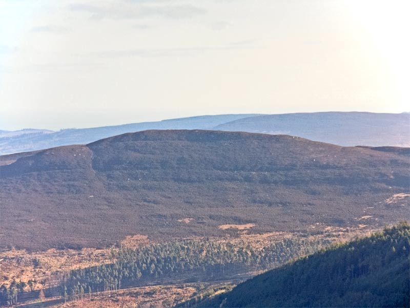
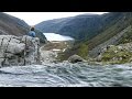
Picture: Derrybawn from west with ridge extending to the right.
Derrybawn has a great situation, looking into four glacial valleys and above the well known Glendalough lakes. The summit is the north end of a 1.6km ridge, the best formed in Wicklow. Many of its lower slopes are planted with mature oak trees.
From the north east it is possible to ascend from the large lake's edge at around UpCP (T1118 9640) initially using the well developed tourist and forestry paths that go beside the Poulanass waterfall and then, more steeply, aiming for a corner in the forest at A (T1146 9568) over small paths. There is an eroded path through high heather to the top. Another possible ascent is from the "Shay Elliott" memorial at around B (T129 922), going W over Cullentragh Mountain (not currently an MV listed summit) and then turning NE on a seriously eroded path through high heather to the south end of the Derrybawn ridge.
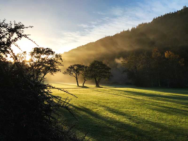
Glendalough can be a truly magical place - especially when there are no tourists there. I was lucky to arrive at the foot of Derrybawn (whose western slope is visible in the background) just after sunrise on an autumn morning in 2017. The prevailing weather conditions had contrived to create an eerie mist illuminated by bright early morning sunshine. I can see why the monks who long ago inhabited this place made a spiritual connection with it. Linkback: mountainviews.ie/summit/537/comment/19960/
Read Less
Read More
darrenf on Derrybawn Mountain
by darrenf
3 Jun 2009
After many years of wondering around the spinc and the lakes of glendalough finally decided to take a ramble around Derrybawn last Friday on a blistering summers day. Started off at the upper lake carpark and headed over the waterfall and turned left over the bridge following the wicklow way. Left the WW and scrambled up to Derrybawn - with such a great day navigation was not a problem.....from Derrybawn went onwards toward Mullaclor and eventually picked up the boardwalk back along the spinc once again and retunred to the car. It was a dry day with a fine spell of weather over the past number of days but the trail was still quiet boggy in places. Lugduff might also be considered as an extension to this walk where one could drop down to the bridge at the old mines before dropping into the valley below. Linkback: mountainviews.ie/summit/537/comment/3799/
Read Less
Read More
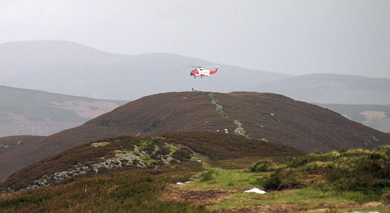
Picture: Helicopter over Derrybawn.
simon3 on Derrybawn Mountain
by simon3
8 May 2007
Derrybawn is famous for its 1.5k ridge stretching SW from the summit. Of course there's many more spectacular ridges elsewhere in Ireland such as the Beenkeragh off Carrauntoohil, the Corranabinnia ridge, the Turks, Slieve League, Bhinn Láir and the Teeromoyle Tooth. But if you live around Dublin, the Derrybawn ridge and the Faninierin ridge are really all there is - The Derrybawn ridge being much easier to incorporate into a looped walk. Sadly the ridge has suffered over the years from trail erosion. There is now a path along its length which has formed entirely in the last 30 years.
Taken from along the ridge, the picture shows what looks like a mountain rescue drill, with the helicopter hovering over the summit.
Derrybawn is the oak-footed southern mouth of the Vale of Glendalough. Steep on its north side, its easily reached from the carpark at the Glendalough Visitor Centre or the car park between the two lakes. I spent around two years in the 70's mapping it for Orienteering purposes - I know Derrybawn in all its seasons and learnt a bit of its history from the former owner of Derrybawn House.
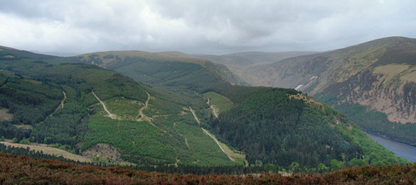
The view here is from its summit towards the west. The tongue of water to the right is part of Glendalough Upper Lake. To the left of it is the Spink. Skyline right is the SW spur of Camaderry. Linkback: mountainviews.ie/summit/537/comment/2685/
Read Less
Read More
brenno on Derrybawn Mountain
by brenno
2 Nov 2007
Was over Derrybawn last weekend as part of the Glendalough-Spink-Mullacor-Derrybawn circuit. First time on this route for a while and sad to say, the underfoot conditions have deteriorated severely. The ridge either side of Derrybawn used to be pretty dry, but last weekend it was very mucky even though there hasn't been an awful lot of rain in the past few weeks. The descent from the end of the Derrybawn ridge back to the upper lake car park has also become very dodgy especially at the end of the circuit when the legs are a bit tired. Hard to know what can be done, but it was quite a shock to see hw badly the underfoot conditions had deteriorated . Linkback: mountainviews.ie/summit/537/comment/2879/
Use of MountainViews is governed by conditions and a privacy policy.
Read general information about the site. Opinions in material here are not necessarily endorsed by MountainViews.
Hillwalking is a risk sport. Information in comments, walks, shared GPS tracks or about starting places may
not be accurate for example as regards safety or access permission. You are responsible for your safety and your permission to walk.
See the credits and list definitions.


 Our Facebook page.