This website uses cookies, which are small text files that the website puts on your device to facilitate operation. Cookies help us provide a better service to you. They are used to track general user traffic information and to help the website function properly.
Starting Places (16) in area South East Midlands: Ballinvarry West, Clodiagh Church, Coolnahau, Coppanagh Wood South, Freney's Well, Glynn, Gorlough Wood, Hill of Allen, Inistioge, Killamery Wood East, Kylebeg Wood, Lingaun River, Mount Alto Wood, Mullenbeg Wood South, Newtown Upper School, Slievenamon Walk Head
Summits & other features in area South East Midlands: E: Barrow: Clogrennan Hill 336m, Newtown Hill 208m N Cen: Timahoe Hills: Ballaghmore Hill 268m, Cullenagh Mountain 317m, Fossy Mountain 332m, Hewson Hill 261m N: Croghan: Croghan Hill 234m N: Newbridge Hills: Dunmurry Hill 233m, Hill of Allen 219m S: Mullinavat: Coolnahau Hill 265m, Corbally Hill 285m, Mount Alto 276m, Tory Hill 292m S: Slievenamon: Knockahunna 502.8m, Sheegouna 553.5m, Slievenamon 720.2m, Slievenamon North-West Top 564m S: Windgap: Carricktriss Gorse 314m, Carrigadoon Hill 296.9m, Faranaree Hill 283m SE: Brandon Hill: Brandon Hill 515m, Coppanagh 365m, Croghan 365m W Cen: Durrow: Ballynalacken Hill 314m, Caponellan Hill 253m, Knockmannon Hill 315m W Cen: Slieveardagh: Clomantagh Hill 349m, Knocknamuck 340m, Monabrogue 284m W: Horse & Jockey: Kill Hill 241m, Killough 235m
Note: this list of places may include island features such as summits, but not
islands as such.
Carricktriss Gorse, 314mHill
Place Rating ..
, Kilkenny County in Leinster province, in Binnion Lists, Carricktriss Gorse is the 1128th highest place in Ireland.
Grid Reference S48312 29103,
OS 1:50k mapsheet 75 Place visited by: 25members, recently by: Nailer1967, benjimann9, John.geary, TippHiker, dregish, TommyV, conormcbandon, Barry28213, Pepe, jasonmc, Garmin, chalky, eamonoc, la1ena, thomasgaffney
I visited this place: NO (You need to be a logged-in member for this.)
Longitude: -7.290748, Latitude: 52.411754, Easting: 248312, Northing: 129103,
Prominence: 169m, Isolation: 4.7km, Has trig pillar
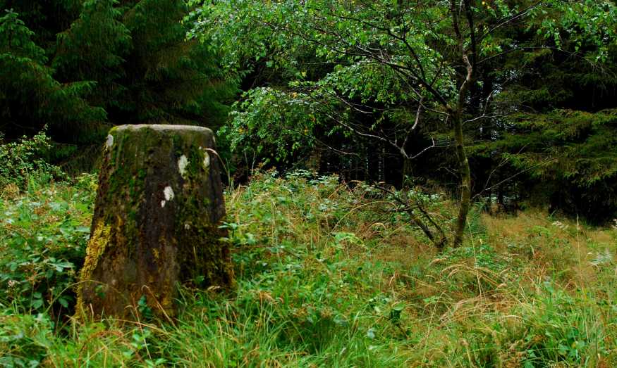
ITM: 648252 629152 Bedrock type: Green pyroclastic rock, dark silty slate, (Carricktriss Formation) Notes on name: Located in the townland of Mullenbeg. Carricktriss Gorse is the highest point in the Walsh Mountains. It is unusual that the element Gorse has been added to this name, but the most likely explanation is the simple one: gorse is abundant on this hill and was probably even more abundant before conifers were planted here. In English place-names gorse is used not only of the plant itself but also of an area where it grows abundantly. It seems likely that Carricktriss Gorse is a rare Irish example of the same kind of place-name.
Short or GPS IDs, 6 char: CrckGr, 10 char: CrcktrsGrs Linkback: https://mountainviews.ie/summit/941/
Gallery for Carricktriss Gorse and surrounds
Summary
for Carricktriss Gorse :
Simple to walk up with a unique view to the west
Summary created by jackill, wicklore
2012-08-03 08:37:13
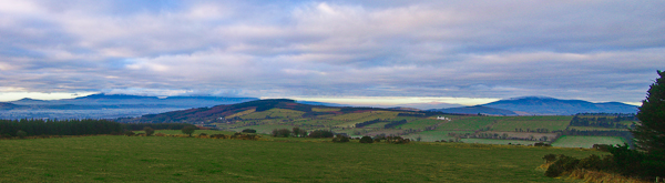
Picture: West over fields to the Comeraghs and Slievenamon
Park at the forest entrance at MulBeg (S48150 28150) next to a house on your right.
Watch out for the dogs from this house,(they were fenced in when I was here but that was at 7:30 am), as they strike me as a potential hazard waiting to happen.
Walk uphill on a wide forest track ignoring the first turn to the right , this will see you in a large turning circle after approximately 1 km.On the left side of this turning circle you will see a gap in the trees and a rough track leading uphill from it. A short distance up this track cross into the open field to your left and continue uphill to the forest corner. Cross the wire fence and going uphill through the conifers will see you at the trig pillar in 2/3 minutes. Instead of crossing into the field you can also continue along the forest track here and find your way to the summit by taking the second trail into the trees at A (S48324 28940). The trig pillar is situated in a small clearing in the coniferous forest, where a few silver birch trees also flourish. There are no views at the summit itself due to the surrounding trees.
New Safe access to this hill no longer seems possible
by TommyMc
2 May 2024
Safe access to this hill no longer appears possible via the turning circle at the end of the forest access track mentioned by other contributors.
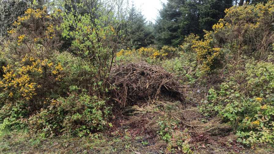
This is because large mounds of wood cuttings waste have been dumped at the few points from which it was previously possible to access the forest proper from the turning circle. It may be possible to negotiate one of these mounds with due care but I didn't frankly consider it worth risking injuring myself.
I couldn't find any other viable option to access the hill. The gate at the field behind the house has 2 signs forbidding trespass. Linkback: mountainviews.ie/summit/941/comment/24189/
Read Less
Read More
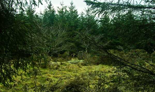
Picture: Furze and Conifers
jackill on Carricktriss Gorse
by jackill
7 Mar 2010
Well now an unusual name for a small hill. The biggest difficulty here is dodging the Rottweiler in the house next to the wood entrance at MulBeg (S48150 28150). Walk uphill following the track until it ends, look left, see a gap in the trees and follow the rough, thorny track uphill until you can walk through a gap in the ditch into a field.Turn right and walk up to the right angle corner of the field. Hop the wire and walk uphill into the forest for couple of minutes to the lonely pillar. Incidentally at the risk of being simplistic there is quite a bit of gorse on the hill, and lots of dead gorse bushes under the forest canopy suggesting it was more widespread before Coillte arrived! Linkback: mountainviews.ie/summit/941/comment/4479/
Read Less
Read More
Different approach, same result
by Pepe
10 Apr 2017
Parked as per instructions - no dogs thankfully. Unlike Jackhill & Wicklore I did take that first turn right about 100 yards up from the house and proceeded about three quarters of a kilometre east along that track. I spied a field about fifty metres in through a stand of trees on my left, and made my way through easily enough to a simple electric wire fence. Over that and diagonally up across two fields, through a gate and due west to the obvious high point. Here access into the trees is easy. I wandered around a bit looking for the trig and then saw the little oasis of silver birches mentioned in a previous post. This is a delightful setting for the trig. No views up top but back in the field there's a great view of the Blackstairs. Going downward on the trail a good vista looking south at Tory Hill, Crobally Hill, etc. Back at the car parking spot there's a great view due west to the Comeragh Gap, Knockanaffrin, etc. Linkback: mountainviews.ie/summit/941/comment/18880/
Read Less
Read More
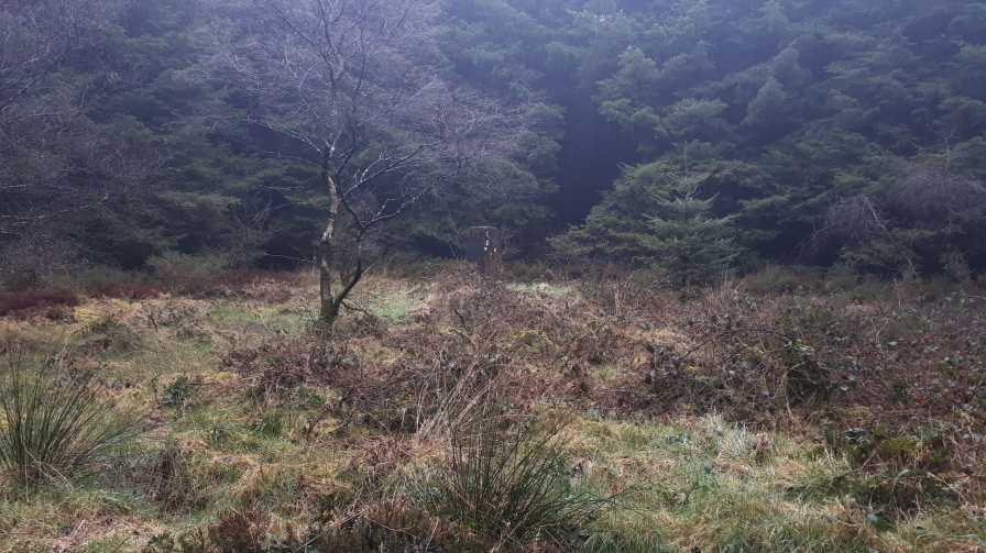
Picture: Trig in the woods
Looking for a trig in the trees.
by TommyV
18 Mar 2019
Followed the directions provided by wicklore and jackhil. Happy to report that there is no sign of the rottweiler but the house does have a beware of the dog sign. Just to mention it's possible to stay on the forest side of the fence if there is livestock in the field and you would rather stay off private farmland. Linkback: mountainviews.ie/summit/941/comment/20458/
Use of MountainViews is governed by conditions and a privacy policy.
Read general information about the site. Opinions in material here are not necessarily endorsed by MountainViews.
Hillwalking is a risk sport. Information in comments, walks, shared GPS tracks or about starting places may
not be accurate for example as regards safety or access permission. You are responsible for your safety and your permission to walk.
See the credits and list definitions.


 Our Facebook page.