Cookies.
This website uses cookies, which are small text files that the website puts on your device to facilitate operation. Cookies help us provide a better service to you. They are used to track general user traffic information and to help the website function properly.
Features
Nearby features appear when you click the map.
Declutter tracks on map.
Place Search
Video
X
Pub: by
MacGillycuddy's Reeks Area , Cen: Reeks West Subarea
Feature count in area: 29, all in Kerry, OSI/LPS Maps: 78, EW-KNP, EW-R
Highest Place: Carrauntoohil 1038.6m

Starting Places (19) in area MacGillycuddy's Reeks:
Ballaghbeama Gap, Bridia Valley End, Cronins Yard, Gap of Dunloe Head of, Gap of Dunloe Kate K, Glashaknockbrassel Stream, Glasheenoultagh Stream, Hydro Road CP, Knocknsallagh Bridge, Lisleibane Trail Head, Lough Acoose North, Lough Acoose West, Lough Cappanlea OEC, Lough Caragh SW, Lough Fada N, Lough Reagh N, Maghanlawaun Bridia Valley, Shamrock Farmhouse B&B, Tomies Lough Leane NW

Summits & other features in area MacGillycuddy's Reeks:
Cen: Reeks West: Beenkeragh 1008.2m, Caher 1000m, Caher West Top 973.4m, Carrauntoohil 1038.6m, Cnoc Íochtair 746.3m, Hag's Tooth 662m, Knockbrinnea East Top 845.4m, Knockbrinnea West Top 852.2m, The Bones Peak 956.5m, Skregmore 847.7m, Stumpa Bharr na hAbhann 852.1m
E: Cnoc an Bhráca: Cnoc an Bhráca 728m, Cnoc na dTarbh 655m, Strickeen 440m
N: Reeks North: Knockbrack 425m, Knocknabrone Hill 353m, Skregbeg 573m
NW: Gortnagan: Gortnagan Beg 298m
SE: Reeks East: Brassel Mountain 575m, Cnoc an Chuillinn 954.6m, Cnoc an Chuillinn East Top 922.9m, Knocknapeasta 985.1m, Cnoc na Toinne 844.1m, Cruach Mhór 930.8m, Maolán Buí 968.9m, The Big Gun 939.9m
SW: Bridia: Beann Bhán 459.5m, Beendarrig 449.7m, Beann Dubh 450.5m

Note: this list of places may include island features such as summits, but not islands as such.
Rating graphic.
Hag's Tooth, 662.0m Mountain Stumpa an tSaimh A name in Irish,
Place Rating ..
(Ir. Stumpa an tSaimh [TH], 'stump of the sorrel') Stumpeenadaff an extra name in English, Kerry County in Munster province, in Arderin Beg, Vandeleur-Lynam, Irish Best Hundred Lists, Hag's Tooth is the 178th highest place in Ireland.
Grid Reference V80958 85044, OS 1:50k mapsheet 78
Place visited by: 218 members, recently by: daitho9, MeabhTiernan, Ansarlodge, No1Grumbler, rhw, maoris, ToughSoles, muddypaws, Kaszmirek78, Krzysztof_K, leonardt, osullivanm, overthehill67, derekfanning, Carolyn105
I visited this place: NO (You need to be a logged-in member for this.)
Longitude: -9.734255, Latitude: 52.005177, Easting: 80958, Northing: 85045, Prominence: 27.3m,  Isolation: 0.7km
ITM: 480934 585103
Bedrock type: Well-bedded grey sandstone, (Lough Acoose Sandstone Formation)
Notes on name: The rock is remarkably unstable on the western slopes and boulders can tumble down unexpectedly. Also known as Stumpeenadaff, from Ir. Stuimpín an Daimh [OSNB], 'little pinnacle of the ox'. Previously Stoompeenaduff in MV.
  Short or GPS IDs, 6 char: HgsTth, 10 char: Hags Tooth

Linkback: https://mountainviews.ie/summit/193/
Gallery for Hag's Tooth (Stumpa an tSaimh) and surrounds
Summary for Hag's Tooth (Stumpa an tSaimh): Rocky airy pinnacle requiring scrambling and good conditions, has great views.
Summary created by simon3, jackill 2023-09-07 09:32:01
            MountainViews.ie picture about Hag's Tooth (<em>Stumpa an tSaimh</em>)
Picture: View from O'Sheas track
An early version of this short summary said this is "A trip to the Dentist is less frightening" and certainly it requires an exposed scramble at the top. Do not attempt in bad weather or if you are not an experienced scrambler.

There are 2 main carparks to access this side of the 'Reeks,
Lisleibane A (V82600 87450) and Cronins Yard Cronins (V83600 87300).

From either of these follow the track to B (V82150 85350) just before the stream from Lough Gouragh.
Go right here skirting to the right of the stream and lake, all the time keeping to the rocky slopes to your right aiming for C (V81600 85100) and you will pick up the track that leads to the Heavenly Gates/O'Sheas Gully routes to Carrauntoohil.

One way up. Cross the stream and come to a grassy gully at D (V81200 85000). This is steep but climbable and you will pick up a faint track as you gain height. Climb this gully, skirting to the right when the base of the rocky outcrop of the Tooth appears above you.

Second way up. Stay to the right of the stream that is to the right of the summit. Climb into the coum beneath Beenkeragh/ The Knockbrinneas until you are roughly level with the col between Hag's Tooth and Beenkeragh. Climb from the col.

The summit is really only a pinnacle of rock and a calm day and a head for heights is a must to stand on it.

track/4937 is useful as a straight up and down route.
Linkback: mountainviews.ie/summit/193/comment/4953/
Member Comments for Hag's Tooth (Stumpa an tSaimh)

            MountainViews.ie picture about Hag's Tooth (<em>Stumpa an tSaimh</em>)
Picture: Ascent of gully to Stumpa an tSaimh
Updated This might hurt
by No1Grumbler 8 Jul 2024
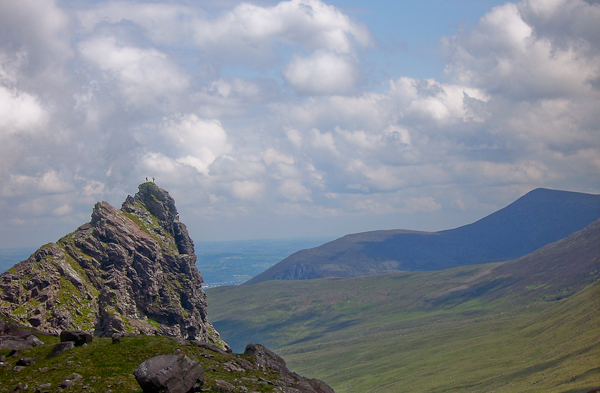
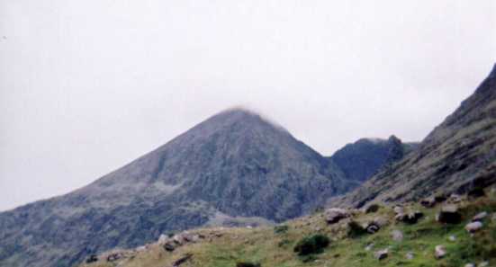
Like 1950s dentistry, my pursuit of the Vandeleur-Lynams over 30 years is rarely elegant and sometimes painful. I knew that eventually I would have to climb Stumpa a’ tSaimh. This hill had tortured my dreams. Sadly, my grumbling chums stayed in Kildare, while I ventured to Cronin’s yard. I slept fitfully through an impressive lightening storm, witnessing the gods throwing bolts around the Reeks. Being what the Scots call a “Feartie”, I arranged for Richard, a local to help me. The rain was easing, but the Hags glen remained clagged in as we set off up the Com road. We cut right on the trail, as if making for O’Shea’s gully. The track took us under the confusingly named Hag’s tooth (543m). What is it with the limited use of names on our hills? The Hag seems to have been blessed by some magical dentistry, because there are multiple incisors, canines and molars all over Kerry. It was the other “Tooth” I wanted. We pressed on, Richard striding purposefully forward, me doing my best to keep up. Beyond Glaise Fhionnchom, we turned right (point D) onto a vague grassy track NW up what is known locally as Green/Holly tree gully- what Simon3 describes as “One way up”. The steep and grassy path meandered between the rocks, ascending to the shattered fragments of the real Tooth- Stumpa a’ tSaimh. This was tough but the rain had stopped, the wind was much reduced, and the clouds were breaking.
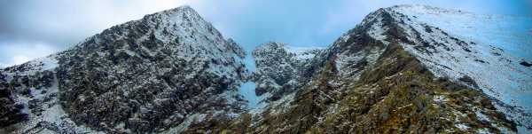
As the slope eased, we did a “Kerry contour” (ie an ascent on slightly less rocky ground) to the NE of the tower and worked our way up to an airy vantage point just West of the final summit and which fell away steeply North. A short corridor took us to the base of summit proper. Here Richard talked me up the short, but exposed scramble until my hands at least could tap the top. The small patch of summit grass was sodden, and the wind noticeable enough to make me wish I had worn darker trousers. Reader, I didn’t stand on the occlusal surface-I remained a “Feartie”, but I don’t care. I still have a handful of VLs to do and I intend to be around to do them. Again, Richard guided me on the short but exposed descent of the distal surface, and we admired Brother O’Shea’s gully and the impressive, but lesser known East ridge of Beenkeeragh. In an adrenaline-fueled haze, we ambled into the Fionnchom bowl, South of Knockbrinnea. It was only midday, so we had lunch in good sunshine on some convenient boulders, watched by the impassive sheep. A lovely descent (Simon & Jackill’s other route) took us down the canyon of Glaise Fhionnchom. I was elated as we hit the trail after some boggy interludes and retraced our steps to Cronin’s yard. There I reflected on irrational fears of scrambling. All had been forgotten in good company. Yes, it was sodden under foot, and windier than I’d have liked, but like a trip to the dentist it was less frightening than I’d imagined, and I was better for the visit. Linkback: mountainviews.ie/summit/193/comment/24204/
Read Less
Read More

Scramblers heaven
by IainT 22 Dec 2016
The direct route up Stumpa an tSaimh and its obvious continuation up the East Ridge of Beenkeragh gives you around 600m of rock, mostly fairly continuous, mostly solid and with great friction. Start just above where the Heavenly Gates path clambers up a little rock step and head right up typical Kerry slabs and shelves with lots of options to a bigger grass shelf below the peak proper. Get onto slabs left of centre and go up right via a little chimney to the skyline, then try to keep to it. Most of it is Grade 2 scrambling, although very airy in places, but there are a couple of harder bits. Memorable are a committing move up left (jammed runner when I was there) and a slightly leaning prow, which has good jugs a little to its left (above a huge drop, falling doesn't bear thinking about). Above this things get easier, but the ridge gets even narrower and quite Alpine feeling. The summit of Stumpa an tSaimh itself is tiny, a spectacular spot. Descent is easiest by going back down a few feet, then using ledges on the north side. There's a lovely sharp slabby arete a bit further on with a steep descent at the far end, easier than it looks but easily avoided on the right. After the col the East Ridge of Beenkeragh is a fun dessert, with lots of optional craglets and pinnacles, gradually easing towards the summit. Then you've still got the Beenkeragh to Corran Tuathail ridge to come, more joy! Linkback: mountainviews.ie/summit/193/comment/18730/
Read Less
Read More

            MountainViews.ie picture about Hag's Tooth (<em>Stumpa an tSaimh</em>)
Picture: Hag's Tooth to the right of Carrauntoohil
murphysw on Hag's Tooth
by murphysw 28 Jul 2005
After climbing Knockbrinnea we descended to the Hags Glen by the stream which runs right by the Hag's Tooth. The stream runs down through a gully near the tooth so care is needed but we found it to be quite safe, although as I mentioned in my comments on Beenkeragh and Knockbrinnea the area is very boulder strewn so watch where you step. If I had known that the tooth was counted as a peak on this site I would have bagged it as we passed right by it! It actually would make the end of an interesting horseshoe for those parked in Cronin's. Carrauntoohil, Beenkeragh, Both Knockbrinneas, and finally Stoompeenaduff (although I dont think I would descend to Stoompeenaduff in wet weather). Linkback: mountainviews.ie/summit/193/comment/1841/
Read Less
Read More

            MountainViews.ie picture about Hag's Tooth (<em>Stumpa an tSaimh</em>)
Picture: Carrauntoohil, oh Brother where are thou and the ridge to Beenkeragh
jackill on Hag's Tooth
by jackill 5 Apr 2010
Some Sundays I get up at 5am to climb a mountain which as you can imagine has caused much debate on my sanity with my wife (who is a mental health nurse, I kid you not!)can you imagine though arriving at Lisleibane at 8am to find cars there before you? madder or closer than me I hope.I approached the Tooth using the standard track to the Heavenly gates/O'Sheas and then ascending the gully mentioned by Conor74, the final scramble to the summit was difficult due to the patches of very slippery wet snow, and you'll need to say hello to a place called vertigo and no wind to stand on the summit(or more probably sit). But you'll probably be alone and on one of the most exciting ridges in Ireland.Of all the approaches to high mountains that I've climbed this challenges the best. I have said this only once before in my MV "career", if you haven't been here before get in the car now and go. Linkback: mountainviews.ie/summit/193/comment/4580/
Read Less
Read More

            MountainViews.ie picture about Hag's Tooth (<em>Stumpa an tSaimh</em>)
Picture: The Hag
Above the clouds
by MickC 7 Feb 2011
The Hag's Tooth taken from the top of Beenkeragh. You can just make out 2 climbers to the right of the tooth. Linkback: mountainviews.ie/summit/193/comment/6237/
Read Less
Read More
EDIT Point of Interest
text
Videos


Users Online

Guests online: 427
Recent Contributions
x
Conditions and Info
Use of MountainViews is governed by conditions and a privacy policy.
Read general information about the site.
Opinions in material here are not necessarily endorsed by MountainViews.
Hillwalking is a risk sport. Information in comments, walks, shared GPS tracks or about starting places may not be accurate for example as regards safety or access permission. You are responsible for your safety and your permission to walk.
See the credits and list definitions.

OSi logo
OSNI/LPS logo
Open Street Map
(Various variations used.)
British summit data courtesy:
Database of British & Irish Hills