Members and Supporters, the MountainViews Committee requests your help to meet the costs of the website and of other activities such as insured events or publications.
Feature count in area: 115, by county: Wicklow: 108, Kildare: 4, Wexford: 2, Carlow: 3, of which 1 is in both Wexford and Wicklow, of which 1 is in both Carlow and Wicklow,
OSI/LPS Maps: 28B, 55, 56, 61, 62, AWW, EW-DM, EW-LG, EW-WE, EW-WS
Highest Place: Lugnaquilla 924.7m
Starting Places (205) in area Wicklow: 1916 Memorial Car Park, Aghavannagh Ow Bridge, Aghowle Wood, Altidore Wood Entrance, Annacurra National School, Annalecka Bridge, Asbawn Brook L8350, Aughrim National School, Ballard Road, Ballinabarny Gap, Ballinagappoge Bridge Layby, Ballinagappoge Mountain Hairpin, Ballinagore, Ballinahinch Wood, Ballinastoe MBT CP, Ballinastraw South, Ballineddan Upr Fork, Ballinfoyle Upr Cross, Ballycoog, Ballycreen Brook Bridge, Ballycumber, Ballycumber Bridge, Ballycumber Lane, Ballycumber Wicklow Way, Ballylerane, Ballylow Bridge, Ballylusk Quarry, Ballymanus Lane, Ballymoyle Shooting Lodge, Ballynultagh Gap, Ballynultagh Lane, Ballyreagh Wood, Ballyross Forest, Ballysmuttan Long Stone, Baravore, Barnbawn South, Barranisky North, Barranisky West, Bohilla Land Roundabout, Bohilla Lane Mid, Boranaraltry Bridge, Bray Harbour, Brewel West, Brittas Bay North CP, Buckroney Sand Dunes CP, Bus Terminus, Camera Hill Track Cross, Castletimon Wood North, Clara Vale, Clone House Road, Clonegal, Cloon Wood Cp, Coate Bridge, Coolballintaggart Ledge, Coolbawn House Lane, Cransillagh Brook , Crone Wood CP, Crossbridge, Crossoona Rath, Cummer Wood South, Curtlestown Wood CP, Deputy's Pass CP, Derralossary Church, Derry River Bridge, Devil's Glen CP, Devil's Glen Wood, Djouce Wood Calary, Djouce Wood Lake, Djouce Wood Long Hill, Donard, Donnelly's Lane Car Sales, Drumgoff Forest, Dunranhill North, Dunranhill SE, Dunranhill South, Dwyer McAllister Cottage CP, Enniskerry, Fentons Pub, Fitzsimons Park GAA, unuseableFlemings Footbridge Glen Rd, Gap Pub, Gap Road, Glen Beach CP, Glen of the Downs CP, Glenbride Lane, Glenbride Lodge, Glencree Reconciliation, Glendalough, Glenealy GAA, Glenmacnass Tonelagee CP, Glenmalure Hostel, Glenmalure Lodge, Glenmalure Waterfall, Glenview Hotel, Gowle House, Great Sugar Loaf CP, Grove Bar, Heffernans Well Wood, Hill View, Hollywood Glen, JB Malone CP, Johnnie Fox Pub, Keadeen NE trail, Keadeen Trailhead, Kevins Way Footbridge, Kilbride Army Camp Entrance, Kilcandra South, Kilcommon View, Killalongford Wood, Kilmacrea Cross Roads, Kilranelagh House Gate, Kilruddery Car Park, Kilruddery Cottages, Kings River, Kippure Bridge, Kippure Estate, Kippure Transmitter Gate, Knickeen Cross, Knocknaboley Lane Leeraghs Bog, Knocknaboley Lane Stone Cottage, Knockrath Little, Knockree west, Kyle Loop North, Lackan Wood S, Lake Dr Fraughan Brook, Lake Drive, Lake Park Cross, Lake View Pub, Laragh Free Car Park, Laragh NSch, Lead Mines CP, Liffey Bridge, Liffey Head Bridge, Lough Bray Lower, Lough Bray Upper, Lough Tay North Viewing Point, Lough Tay Wicklow Way CP, Luglass Lane L97561, Lugnagun Track, Macreddin Village, Mangans Lane, Military Road Carrigshouk Hill, Military Road Inchavore River Nth, Military Road Inchavore River Sth, Military Road NW Lough Tay, Military Road Ballyboy Bridge, Military Road Cloghoge Brook, Military Road Croaghanmoira, Military Road Fananierin, Military Road LaraghWicklow Way, Military Road Slieve Maan, Monspolien Bridge, Moortown House, Mountain Rescue HQ, Muskeagh Little Wood, Nahanagan Lough NE, Novara Avenue, Bray, Oiltiagh Brook Knickeen, Old Bridge Cross, Old Bridge Scouts , Old Wicklow Way entrance, Paddock Hill SE, Pier Gates CP, Powerscourt Waterfall CP, Putland Road, Quintagh East, Raheen Park CP, Raheenleagh East, Railway Walk CP, Rathdrum Railway Station, Rednagh Wood, Rocky Valley, Roundwood, Sally Gap, Sally Gap N, Seefin Trailhead, Seskin SE, Shankill Tributary Bridge, Shay Elliott, Sheepshanks Bridge, Shillelagh, Slievecorragh Track, Slievefoore South, Sraghoe Brook, St John's Church, St Kevins Chair, St Kevins Church, St Kevins Way R756, Stone Circle Bridge, Stookeen South, Stranahely Wood, Stranakelly Cross Roads, Tallyho, Templeboden, Tithewer, Tomcoyle L, Tomriland Wood, Toor Brook, Trooperstown Hill Access, Turlough Hill CP, Upper Lake CP, Vallymount GAA CP, Vartry Reservoir Upper, Zellers Pub
Summits & other features in area Wicklow: Cen: Glendalough North: Brockagh Mountain 556.9m, Brockagh Mountain NW Top 549.5m, Brockagh Mountain SE Top 471.7m, Camaderry East Top 677.3m, Camaderry Mountain 698.6m, Conavalla 734m, Tomaneena 682.4m Cen: Glendalough South: Carriglineen Mountain 456.6m, Cullentragh Mountain 510m, Derrybawn Mountain 476.1m, Kirikee Mountain 474.5m, Lugduff 653.2m, Lugduff SE Top 638m, Mullacor 660.7m, Trooperstown Hill 430m N Cen: Tonelagee: Carrignagunneen 561m, Fair Mountain 571.2m, Stoney Top 713.7m, Tonelagee 815.8m, Tonelagee E Top 668m, Tonelagee South-East Top 545.8m NE: Bray & Kilmacanogue: Bray Head Hill 238.9m, Carrigoona Commons East 242m, Downs Hill 372.9m, Great Sugar Loaf 501.2m, Little Sugar Loaf 342.4m NE: Djouce: Djouce 725.5m, Knockree 342.1m, Maulin 570m, Tonduff 642m, Tonduff East Top 593m, War Hill 684.8m, White Hill 631.1m NE: Fancy: Ballinafunshoge 480m, Kanturk 527.4m, Knocknacloghoge 532.4m, Luggala 593.3m, Robber's Pass Hill 508.9m, Scarr 640m, Scarr North-West Top 559.8m, Sleamaine 430m NE: Vartry: Ballinacorbeg 336m, Ballycurry 301m, Dunranhill 342m, Mount Kennedy 365.9m NW: Blessington: Carrigleitrim 408m, Lugnagun 446.2m, Slieveroe 332m, Sorrel Hill 599.5m NW: Mullaghcleevaun: Black Hill 602.2m, Carrigshouk 572.5m, Carrigvore 682.4m, Duff Hill 720.8m, Gravale 719m, Moanbane 703m, Mullaghcleevaun 846.7m, Mullaghcleevaun East Top 796m, Silsean 698m S: Aughrim Hills: Cushbawn 400m, Killeagh 249m, Moneyteige North 427m, Preban Hill 389m S: Croaghanmoira: Ballinacor Mountain 529.3m, Ballycurragh Hill 536m, Ballyteige 447m, Carrickashane Mountain 508m, Croaghanmoira 662.3m, Croaghanmoira North Top 579.5m, Fananierin 426m, Slieve Maan 547.8m, Slieve Maan North Top 546.1m S: Croghan Kinsella: Annagh Hill 454m, Croghan Kinsella 606m, Croghan Kinsella East Top 562.1m, Slievefoore 414m S: Shillelagh Hills: Lakeen 357m, Monaughrim 206m, Seskin 344m, Stookeen 420m S: Tinahely Hills: Ballycumber Hill 429.7m, Eagle Hill 296m, Muskeagh Hill 398.2m SE: Wicklow South East: Ballinastraw 284m, Ballyguile Hill 188m, Barranisky 280m, Carrick Mountain 381m, Collon Hill 238m, Kilnamanagh Hill 217m, Westaston Hill 270m W: Baltinglass: Ballyhook Hill 288m, Baltinglass Hill 382m, Carrig Mountain 571m, Carrigeen Hill 298m, Cloghnagaune 385m, Corballis Hill 258m, Keadeen Mountain 653m, Spinans Hill 409m, Spinans Hill SE Top 400m, Tinoran Hill 312m W: Cen Lugnaquilla: Ballineddan Mountain 652.3m, Benleagh 689m, Camenabologue 758m, Camenabologue SE Top 663m, Cloghernagh 800m, Corrigasleggaun 794.6m, Lugnaquilla 924.7m, Slievemaan 759.7m W: Donard: Brewel Hill 222m, Church Mountain 544m, Corriebracks 531m, Lobawn 636m, Slievecorragh 418m, Sugarloaf 552m, Table Mountain 701.7m, Table Mountain West Top 563m
Note: this list of places may include island features such as summits, but not
islands as such.
Keadeen Mountain, 653mMountain Céidín A name in Irish,
Place Rating ..
(Ir. Céidín [OSI], 'flat-topped hill'), Wicklow County in Leinster province, in Arderin, Vandeleur-Lynam, Irish Highest Hundred Lists, Keadeen Mountain is the 193rd highest place in Ireland.
Grid Reference S95394 89764,
OS 1:50k mapsheet 62 Place visited by: 439members, recently by: rhw, Sophie-Hayes, Courin, Hjonna, knightsonhikes, Dee68, davidrenshaw, Magic, Prem, Carolineswalsh, ConMack23, lauracardiff, benjimann9, ToughSoles, muddypaws
I visited this place: NO (You need to be a logged-in member for this.)
Longitude: -6.581498, Latitude: 52.950512, Easting: 295394, Northing: 189764,
Prominence: 334m, Isolation: 1.4km, Has trig pillar
ITM: 695323 689800 Bedrock type: Dark slate-schist, quartzite & coticule, (Butter Mountain Formation) Notes on name: Keadeen Mountain is not obviously flat-topped either when seen from the N (Church Mtn) or from the contours on the map. Céide can also mean a path, way or a place of assembly, fair site, etc. One of these other meanings may be relevant in this case. As it is a townland name, it may not refer to the mountain originally.
Short or GPS IDs, 6 char: KdnMnt, 10 char: KdnMntn Linkback: https://mountainviews.ie/summit/186/
Gallery for Keadeen Mountain (Céidín) and surrounds
Summary
for Keadeen Mountain (Céidín):
An attractive peak with great views - access issues abound.
Summary created by markmjcampion, simon3, Harry Goodman
2023-06-19 15:33:16
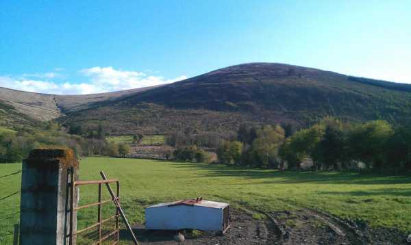
Picture: Keadeen Mountain
Keadeen is a shapely, steep-sided hill in the SW part of the Wicklow Mountains. It’s a grassy peak and maybe this has caused it’s undoing as a place of recreation as traditional ascent routes from the N and W have been ruled out due to farmers’ concerns. Because of that, there appears to be only one safe access point - to the East. There are great views from the top esp. of the local hills and dales as well as south to Mt. Leinster and west over the plains of Kildare.
E. Park near to Keadeen TH (S98494 89500). Follow the southern edge of the forest and upon reaching A (S96643 89798) swing SW for some 300m before veering W and then NW up the shoulder of Keadeen Mt.
Alternatively, from the same starting point head NW into the forest and follow trails until you reach the end of the road at B (S97015 90064). You will see a track that leads to a gate and a fence. Go through the gate and turn left up the track keeping the fence on your left until the corner where the fence turns left C (S96791 89791). From here follow the directions above.
Allow 1hrs+ for either route.
N. Previously this was accessed from Dwyer/Mc Allister cottage car park Dwyer Ctg (S96634 91281), however there are access issues here and it should not be attempted from here.
W. There are access issues from this side too so it’s best avoided from here.
Track/4401 and similar are the only valid ones at the time of writing [June 2023]
Many people are finding the usual route from the Dwyer/McAllister cottage a bit offputting with the signage etc.
An alternative route is to start at the forest road entrance at the Ballinabarney gap Keadeen TH (S98460 89524) Room for 3 cars.
Follow the forestry road, always taking the left hand fork until you reach the end of the road at B (S97015 90064). You will see a track that leads to a gate and a fence. The fence is damaged so best not to cause any further damage' Go through the gate and turn left up the track keeping the fence on your left until the corner where the fence turns left C (S96791 89791). There is a well worn track heading up hill that leads directly to the top of keadeen.
There is evidence of previous break ins at the forest gate, broken glass etc so it wont be as secure as the car park at the cottage. Still, there don't seem to be any access issues. Linkback: mountainviews.ie/summit/186/comment/19734/
Read Less
Read More
Western Views
by csd
14 Jul 2012
Because of Keadeen's somewhat isolated position at the western edge of the Wicklow mountains there are some great views from the top. Here's Balineddan, Slievemaan and Lugnaquilla (in cloud as usual) viewed from Keadeen. We came up the western side from Ballinabarry Gap (Keadeen TH (S985 895)) handrailing the forest at first and then following the heavily eroded track the rest of the way to the summit. Sadly the track has been badly cut up by scramblers/quad bikes. Linkback: mountainviews.ie/summit/186/comment/717/
Read Less
Read More
GWPR on Keadeen Mountain
by GWPR
7 Apr 2003
From Blessington continue on the n81 to turn left for Donard.
In Donard go left and next right to pass the Youth Hostel on the left.
Take next right to Knockarrigan. Now follow signs for Dwyer/McAllister Cottage.
Park in small Car Park opposite cottage.
Leave Car Park and follow road to right to reach forest track on left.
Follow forest track and at first bend enter wood to follow edge of wood.
Where the wood ends on your right there is a track all the way to the summit.
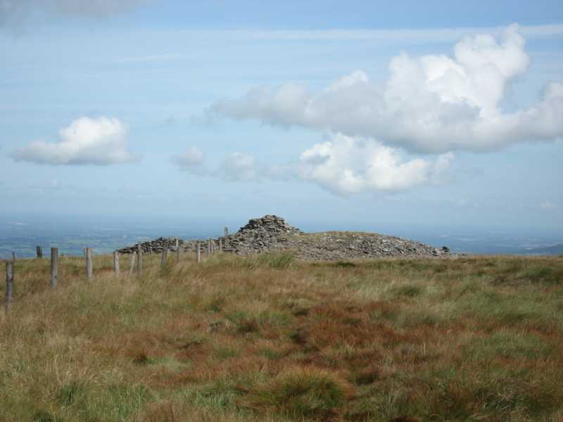
The summit has a scattered cairn and a trig point.
The walls circling the Brusselstown Ring , the biggest ringfort in Ireland , can be seen to the NW. It was constructed in the Iron Age to guard the entrance to the rich farmland of the Glen of Imaal.
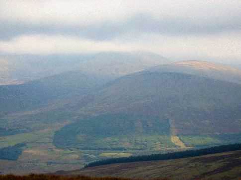
To the East Lugnacoille and it’s neighbours are impressive.
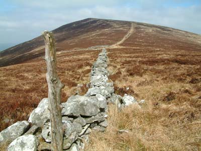
From the summit head south following a fence and later a stone wall
to reach Carrig which has a small cairn. The view back to Keadeen is beautiful.
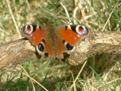
On my way back I saw this beautiful butterfly! Linkback: mountainviews.ie/summit/186/comment/430/
Read Less
Read More
evelyn on Keadeen Mountain
by evelyn
25 Jun 2004
I've climbed Keadeen twice from Ballinabarney Gap, once I've left my car there, it's just the mountain and me, unlike many of the other mountains in the Wicklow area, it's not such a popular mountain to climb. That makes it all the better for the rest of us who know what fantastic views you can get once at the top, and you have it all to yourself! Linkback: mountainviews.ie/summit/186/comment/1000/
Use of MountainViews is governed by conditions and a privacy policy.
Read general information about the site. Opinions in material here are not necessarily endorsed by MountainViews.
Hillwalking is a risk sport. Information in comments, walks, shared GPS tracks or about starting places may
not be accurate for example as regards safety or access permission. You are responsible for your safety and your permission to walk.
See the credits and list definitions.


 Our Facebook page.