Members and Supporters, the MountainViews Committee requests your help to meet the costs of the website and of other activities such as insured events or publications.
Feature count in area: 115, by county: Wicklow: 108, Kildare: 4, Wexford: 2, Carlow: 3, of which 1 is in both Wexford and Wicklow, of which 1 is in both Carlow and Wicklow,
OSI/LPS Maps: 28B, 55, 56, 61, 62, AWW, EW-DM, EW-LG, EW-WE, EW-WS
Highest Place: Lugnaquilla 924.7m
Starting Places (205) in area Wicklow: 1916 Memorial Car Park, Aghavannagh Ow Bridge, Aghowle Wood, Altidore Wood Entrance, Annacurra National School, Annalecka Bridge, Asbawn Brook L8350, Aughrim National School, Ballard Road, Ballinabarny Gap, Ballinagappoge Bridge Layby, Ballinagappoge Mountain Hairpin, Ballinagore, Ballinahinch Wood, Ballinastoe MBT CP, Ballinastraw South, Ballineddan Upr Fork, Ballinfoyle Upr Cross, Ballycoog, Ballycreen Brook Bridge, Ballycumber, Ballycumber Bridge, Ballycumber Lane, Ballycumber Wicklow Way, Ballylerane, Ballylow Bridge, Ballylusk Quarry, Ballymanus Lane, Ballymoyle Shooting Lodge, Ballynultagh Gap, Ballynultagh Lane, Ballyreagh Wood, Ballyross Forest, Ballysmuttan Long Stone, Baravore, Barnbawn South, Barranisky North, Barranisky West, Bohilla Land Roundabout, Bohilla Lane Mid, Boranaraltry Bridge, Bray Harbour, Brewel West, Brittas Bay North CP, Buckroney Sand Dunes CP, Bus Terminus, Camera Hill Track Cross, Castletimon Wood North, Clara Vale, Clone House Road, Clonegal, Cloon Wood Cp, Coate Bridge, Coolballintaggart Ledge, Coolbawn House Lane, Cransillagh Brook , Crone Wood CP, Crossbridge, Crossoona Rath, Cummer Wood South, Curtlestown Wood CP, Deputy's Pass CP, Derralossary Church, Derry River Bridge, Devil's Glen CP, Devil's Glen Wood, Djouce Wood Calary, Djouce Wood Lake, Djouce Wood Long Hill, Donard, Donnelly's Lane Car Sales, Drumgoff Forest, Dunranhill North, Dunranhill SE, Dunranhill South, Dwyer McAllister Cottage CP, Enniskerry, Fentons Pub, Fitzsimons Park GAA, unuseableFlemings Footbridge Glen Rd, Gap Pub, Gap Road, Glen Beach CP, Glen of the Downs CP, Glenbride Lane, Glenbride Lodge, Glencree Reconciliation, Glendalough, Glenealy GAA, Glenmacnass Tonelagee CP, Glenmalure Hostel, Glenmalure Lodge, Glenmalure Waterfall, Glenview Hotel, Gowle House, Great Sugar Loaf CP, Grove Bar, Heffernans Well Wood, Hill View, Hollywood Glen, JB Malone CP, Johnnie Fox Pub, Keadeen NE trail, Keadeen Trailhead, Kevins Way Footbridge, Kilbride Army Camp Entrance, Kilcandra South, Kilcommon View, Killalongford Wood, Kilmacrea Cross Roads, Kilranelagh House Gate, Kilruddery Car Park, Kilruddery Cottages, Kings River, Kippure Bridge, Kippure Estate, Kippure Transmitter Gate, Knickeen Cross, Knocknaboley Lane Leeraghs Bog, Knocknaboley Lane Stone Cottage, Knockrath Little, Knockree west, Kyle Loop North, Lackan Wood S, Lake Dr Fraughan Brook, Lake Drive, Lake Park Cross, Lake View Pub, Laragh Free Car Park, Laragh NSch, Lead Mines CP, Liffey Bridge, Liffey Head Bridge, Lough Bray Lower, Lough Bray Upper, Lough Tay North Viewing Point, Lough Tay Wicklow Way CP, Luglass Lane L97561, Lugnagun Track, Macreddin Village, Mangans Lane, Military Road Carrigshouk Hill, Military Road Inchavore River Nth, Military Road Inchavore River Sth, Military Road NW Lough Tay, Military Road Ballyboy Bridge, Military Road Cloghoge Brook, Military Road Croaghanmoira, Military Road Fananierin, Military Road LaraghWicklow Way, Military Road Slieve Maan, Monspolien Bridge, Moortown House, Mountain Rescue HQ, Muskeagh Little Wood, Nahanagan Lough NE, Novara Avenue, Bray, Oiltiagh Brook Knickeen, Old Bridge Cross, Old Bridge Scouts , Old Wicklow Way entrance, Paddock Hill SE, Pier Gates CP, Powerscourt Waterfall CP, Putland Road, Quintagh East, Raheen Park CP, Raheenleagh East, Railway Walk CP, Rathdrum Railway Station, Rednagh Wood, Rocky Valley, Roundwood, Sally Gap, Sally Gap N, Seefin Trailhead, Seskin SE, Shankill Tributary Bridge, Shay Elliott, Sheepshanks Bridge, Shillelagh, Slievecorragh Track, Slievefoore South, Sraghoe Brook, St John's Church, St Kevins Chair, St Kevins Church, St Kevins Way R756, Stone Circle Bridge, Stookeen South, Stranahely Wood, Stranakelly Cross Roads, Tallyho, Templeboden, Tithewer, Tomcoyle L, Tomriland Wood, Toor Brook, Trooperstown Hill Access, Turlough Hill CP, Upper Lake CP, Vallymount GAA CP, Vartry Reservoir Upper, Zellers Pub
Summits & other features in area Wicklow: Cen: Glendalough North: Brockagh Mountain 556.9m, Brockagh Mountain NW Top 549.5m, Brockagh Mountain SE Top 471.7m, Camaderry East Top 677.3m, Camaderry Mountain 698.6m, Conavalla 734m, Tomaneena 682.4m Cen: Glendalough South: Carriglineen Mountain 456.6m, Cullentragh Mountain 510m, Derrybawn Mountain 476.1m, Kirikee Mountain 474.5m, Lugduff 653.2m, Lugduff SE Top 638m, Mullacor 660.7m, Trooperstown Hill 430m N Cen: Tonelagee: Carrignagunneen 561m, Fair Mountain 571.2m, Stoney Top 713.7m, Tonelagee 815.8m, Tonelagee E Top 668m, Tonelagee South-East Top 545.8m NE: Bray & Kilmacanogue: Bray Head Hill 238.9m, Carrigoona Commons East 242m, Downs Hill 372.9m, Great Sugar Loaf 501.2m, Little Sugar Loaf 342.4m NE: Djouce: Djouce 725.5m, Knockree 342.1m, Maulin 570m, Tonduff 642m, Tonduff East Top 593m, War Hill 684.8m, White Hill 631.1m NE: Fancy: Ballinafunshoge 480m, Kanturk 527.4m, Knocknacloghoge 532.4m, Luggala 593.3m, Robber's Pass Hill 508.9m, Scarr 640m, Scarr North-West Top 559.8m, Sleamaine 430m NE: Vartry: Ballinacorbeg 336m, Ballycurry 301m, Dunranhill 342m, Mount Kennedy 365.9m NW: Blessington: Carrigleitrim 408m, Lugnagun 446.2m, Slieveroe 332m, Sorrel Hill 599.5m NW: Mullaghcleevaun: Black Hill 602.2m, Carrigshouk 572.5m, Carrigvore 682.4m, Duff Hill 720.8m, Gravale 719m, Moanbane 703m, Mullaghcleevaun 846.7m, Mullaghcleevaun East Top 796m, Silsean 698m S: Aughrim Hills: Cushbawn 400m, Killeagh 249m, Moneyteige North 427m, Preban Hill 389m S: Croaghanmoira: Ballinacor Mountain 529.3m, Ballycurragh Hill 536m, Ballyteige 447m, Carrickashane Mountain 508m, Croaghanmoira 662.3m, Croaghanmoira North Top 579.5m, Fananierin 426m, Slieve Maan 547.8m, Slieve Maan North Top 546.1m S: Croghan Kinsella: Annagh Hill 454m, Croghan Kinsella 606m, Croghan Kinsella East Top 562.1m, Slievefoore 414m S: Shillelagh Hills: Lakeen 357m, Monaughrim 206m, Seskin 344m, Stookeen 420m S: Tinahely Hills: Ballycumber Hill 429.7m, Eagle Hill 296m, Muskeagh Hill 398.2m SE: Wicklow South East: Ballinastraw 284m, Ballyguile Hill 188m, Barranisky 280m, Carrick Mountain 381m, Collon Hill 238m, Kilnamanagh Hill 217m, Westaston Hill 270m W: Baltinglass: Ballyhook Hill 288m, Baltinglass Hill 382m, Carrig Mountain 571m, Carrigeen Hill 298m, Cloghnagaune 385m, Corballis Hill 258m, Keadeen Mountain 653m, Spinans Hill 409m, Spinans Hill SE Top 400m, Tinoran Hill 312m W: Cen Lugnaquilla: Ballineddan Mountain 652.3m, Benleagh 689m, Camenabologue 758m, Camenabologue SE Top 663m, Cloghernagh 800m, Corrigasleggaun 794.6m, Lugnaquilla 924.7m, Slievemaan 759.7m W: Donard: Brewel Hill 222m, Church Mountain 544m, Corriebracks 531m, Lobawn 636m, Slievecorragh 418m, Sugarloaf 552m, Table Mountain 701.7m, Table Mountain West Top 563m
Note: this list of places may include island features such as summits, but not
islands as such.
Conavalla, 734mMountain Ceann an Bhealaigh A name in Irish,
Place Rating ..
(Ir. Ceann an Bhealaigh [PNCW*], 'head of the road/pass'), Cumavally, Cullavalla, Wicklow County in Leinster province, in Arderin, Vandeleur-Lynam, Irish Highest Hundred Lists, Conavalla is the 87th highest place in Ireland.
Grid Reference T03970 97153,
OS 1:50k mapsheet 56 Place visited by: 514members, recently by: rhw, Sophie-Hayes, MartMc, MarionP, Oscar-mckinney, Kirsty, orlaithfitz, maoris, davidrenshaw, Magic, Prem, Carolineswalsh, ConMack23, Nailer1967, ToughSoles
I visited this place: NO (You need to be a logged-in member for this.)
Longitude: -6.451457, Latitude: 53.0151, Easting: 303970, Northing: 197153,
Prominence: 109m, Isolation: 1.8km ITM: 703906 697166 Bedrock type: Dark slate-schist, quartzite & coticule, (Butter Mountain Formation) Notes on name: The second part of the name refers to the old road (bealach) which led from the west over the mountains into Glendalough.
Short or GPS IDs, 6 char: Cnv734, 10 char: Conavalla Linkback: https://mountainviews.ie/summit/86/
Gallery for Conavalla (Ceann an Bhealaigh) and surrounds
Summary
for Conavalla (Ceann an Bhealaigh):
Lonely top well defended by navigationally tricky land & sucking bog.
Summary created by markmjcampion, simon3
2023-08-31 12:16:41
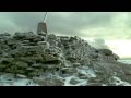
Picture: Conavalla from the south
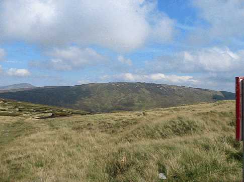
Conavalla has a plain, lonely place at the head of the Glenmalure valley. It's a boggy expanse that lies on both the circuits of Glenmalure and Glendalough with good Wicklow views from Lug up to Tonelegee.
SE. Park at Barravore B'vore (T06606 94182) from where you proceed NW up forest tracks. Aim for A (T03491 96277) from where an ascent can easily be made now that much of the forestry is gone. 6k 1.5-2hrs
NE. Park near the Wicklow Gap at B (O07626 00175), walk the road to Turlough Hill and past Lough Firrib. From here the route is notoriously difficult in misty conditions without a GPS. When wet, which is to say often, the flattish region around 350 to 700m to the NE of the summit has perhaps the worst bog in Wicklow. To avoid much of the bog, head along the traditional route over the disused quarry towards Lough Firrib on 296 degrees, stop at the rocks (T:C (T06045 98347) ) which precede the descent into the Turlough-Firrib boggy arena. From here head resolutely on 246 degrees downwards, then over a shoulder and down to the Glenealo river, and then upwards to Conavalla. Allow 2 – 3 hrs
N. From the N start either at AsbnBk (O02041 01435) or Kevin (O03746 02212) and head up the Glenreemore valley before ascending steeply to Art's Cross D (T03789 98934). Head on to Three Lakes E (O03213 96205) and then up the NW spur of Conavalla. 3hrs+
Track/2090 is a winter-only [frozen bog] route from the NE
Track/3368 is an 18k loop of the head of Glenmalure while track/2334 is a 26k version.
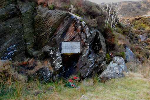
Just west of Art’s Cross (F (T038 991)), a stream tumbles from the plateau to form Gleenreemore Brook in the valley below. Slightly east of the foot of the waterfall can be seen the memorial to Art O’Neill (G (T036 994)), indicating the spot where, according to tradition, he breathed his last. It’s easily missed, since the grassy ramp that marks the beginning of the ascent (or end of the descent) alongside the waterfall takes you away from it. It’s a granite plaque in Irish set into a striated boulder, with a little cross on top. It was placed there, as a few lines tell us at the bottom, by Cumann Siúlóirí na hÉireann in 1992 - the four hundreth anniversary of Art's death - to replace another that had been there since 1932. Although this is a recent memorial, it is sculpted in the elegant demi-uncial script of earlier years, so my guess would be that it has simply copied the 1932 model. Passing by yesterday, 9 Feb. ’08, I noticed several Christmas wreaths were still lying at the foot of the memorial, so obviously Art is no forgotten figure in our history. The fact that he faced the rigours of these hills in winter gives him a place in walkers' hearts, too. Linkback: mountainviews.ie/summit/86/comment/2960/
Read Less
Read More
csd on Conavalla
by csd
14 Sep 2003
Surrounded by sucking bogs, Conavalla can take quite an effort to get to if it's been wet. Beware, the nice fat forest track on the southern side of Conavalla, shown on the Harvey and Hely maps, doesn't extend as far as shown. If you're thinking of using it to head for Lugduff I'd think again! Picture shows Conavalla taken from the top of the Table Track, with Tonlagee in the background on the left. Linkback: mountainviews.ie/summit/86/comment/641/
Read Less
Read More
Picture: Art's Cross
padodes on Conavalla
by padodes
13 Feb 2008
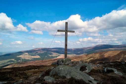
Almost 2 km due north of Conavalla, at the edge of the upland plateau rolling wetly down from the top of the hill and about midway between Lough Firrib and Three Lakes, lies Art’s Cross (F (T038 991)). In pre-GPS days, when thick fog descended on this broken bogland, it could be quite tricky to find the landmark, since the terrain never allowed the walker to follow anything remotely similar to a direct bearing. As it happens, the Cross doesn’t mark the exact spot where, according to tradition, Art O’Neill died in 1592 on his flight from Dublin Castle to Glenmalure with Red Hugh O’Donnell. That spot lies in the valley, below, close to the foot of the nearby waterfall. The view from the top, looking northwards, takes in a beautiful expanse of mountain scenery from Tonelagee in the NE right across to Mullaghcleevaun in the N, and Moanbane and Silsean in the NW (the latter three, left to right, are visible in the photo). Linkback: mountainviews.ie/summit/86/comment/2959/
Read Less
Read More
Tom Milligan on Conavalla
by Tom Milligan
19 Jun 2005
Traversing the boggy area between Lough Firrib and Conavalla can be a source of some nervousness for many, especially in wet conditions, but there is a way to this summit from Turlough Hill which bypasses Lough Firrib and provides a relatively pleasant and bog-free experience. Heading along the traditional route over the disused quarry towards Lough Firrib on 296 degrees, stop at the rocks (T:C (T06045 98347)) which precede the descent into the Turlough-Firrib boggy arena. From here head resolutely on 246 degrees downwards, then over a shoulder and down to the Glenealo river, and then upwards to Conavalla. You'll be asking yourself "Why don't we do this all the time?". Linkback: mountainviews.ie/summit/86/comment/1762/
Read Less
Read More
Picture: Bog
Sometimes a hill doesn't like you
by ewen
6 Jan 2018
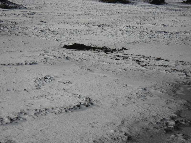
Conavalla hates me. It really does. I finally reached the top on my fourth attempt. Three other attempts were thwarted by weather but I was going to beat it. Third attempt via Tomaneena and I was determined to get it.
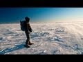
The mountain threw everything it had. Mist, blizzard and bog all combined to try and make me turn back. At one point the ice broke on the bog and I sank over my knees. I got one leg out but the other was stuck fast. I had to sit down and dig out peat with my hands. I then crawled over cracking bog ice to a hag where I considered turning back. No, the top was only a few hundred metres and I did get it.
Returning to Lough Firrib, I took a wide detour to avoid the worst of the bog but Conavalla released her white out. Luckily I had GPS as well as my map so she let me proceed to Tomaneena and down to Wicklow gap.
The bog is a killer but I beat Conavalla. Linkback: mountainviews.ie/summit/86/comment/19834/
Use of MountainViews is governed by conditions and a privacy policy.
Read general information about the site. Opinions in material here are not necessarily endorsed by MountainViews.
Hillwalking is a risk sport. Information in comments, walks, shared GPS tracks or about starting places may
not be accurate for example as regards safety or access permission. You are responsible for your safety and your permission to walk.
See the credits and list definitions.


 Our Facebook page.