Donation Request 2024

DONATE
Members and Supporters, the MountainViews Committee requests your help to meet the costs of the website and of other activities such as insured events or publications.
You do not have to be logged in to donate.
Features
Nearby features appear when you click the map.
Declutter tracks on map.
Place Search
Video
X
Pub: by
Wicklow Area , W: Baltinglass Subarea
Feature count in area: 115, by county: Wicklow: 108, Kildare: 4, Wexford: 2, Carlow: 3, of which 1 is in both Wexford and Wicklow, of which 1 is in both Carlow and Wicklow, OSI/LPS Maps: 28B, 55, 56, 61, 62, AWW, EW-DM, EW-LG, EW-WE, EW-WS
Highest Place: Lugnaquilla 924.7m

Starting Places (205) in area Wicklow:
1916 Memorial Car Park, Aghavannagh Ow Bridge, Aghowle Wood, Altidore Wood Entrance, Annacurra National School, Annalecka Bridge, Asbawn Brook L8350, Aughrim National School, Ballard Road, Ballinabarny Gap, Ballinagappoge Bridge Layby, Ballinagappoge Mountain Hairpin, Ballinagore, Ballinahinch Wood, Ballinastoe MBT CP, Ballinastraw South, Ballineddan Upr Fork, Ballinfoyle Upr Cross, Ballycoog, Ballycreen Brook Bridge, Ballycumber, Ballycumber Bridge, Ballycumber Lane, Ballycumber Wicklow Way, Ballylerane, Ballylow Bridge, Ballylusk Quarry, Ballymanus Lane, Ballymoyle Shooting Lodge, Ballynultagh Gap, Ballynultagh Lane, Ballyreagh Wood, Ballyross Forest, Ballysmuttan Long Stone, Baravore, Barnbawn South, Barranisky North, Barranisky West, Bohilla Land Roundabout, Bohilla Lane Mid, Boranaraltry Bridge, Bray Harbour, Brewel West, Brittas Bay North CP, Buckroney Sand Dunes CP, Bus Terminus, Camera Hill Track Cross, Castletimon Wood North, Clara Vale, Clone House Road, Clonegal, Cloon Wood Cp, Coate Bridge, Coolballintaggart Ledge, Coolbawn House Lane, Cransillagh Brook , Crone Wood CP, Crossbridge, Crossoona Rath, Cummer Wood South, Curtlestown Wood CP, Deputy's Pass CP, Derralossary Church, Derry River Bridge, Devil's Glen CP, Devil's Glen Wood, Djouce Wood Calary, Djouce Wood Lake, Djouce Wood Long Hill, Donard, Donnelly's Lane Car Sales, Drumgoff Forest, Dunranhill North, Dunranhill SE, Dunranhill South, Dwyer McAllister Cottage CP, Enniskerry, Fentons Pub, Fitzsimons Park GAA, unuseableFlemings Footbridge Glen Rd, Gap Pub, Gap Road, Glen Beach CP, Glen of the Downs CP, Glenbride Lane, Glenbride Lodge, Glencree Reconciliation, Glendalough, Glenealy GAA, Glenmacnass Tonelagee CP, Glenmalure Hostel, Glenmalure Lodge, Glenmalure Waterfall, Glenview Hotel, Gowle House, Great Sugar Loaf CP, Grove Bar, Heffernans Well Wood, Hill View, Hollywood Glen, JB Malone CP, Johnnie Fox Pub, Keadeen NE trail, Keadeen Trailhead, Kevins Way Footbridge, Kilbride Army Camp Entrance, Kilcandra South, Kilcommon View, Killalongford Wood, Kilmacrea Cross Roads, Kilranelagh House Gate, Kilruddery Car Park, Kilruddery Cottages, Kings River, Kippure Bridge, Kippure Estate, Kippure Transmitter Gate, Knickeen Cross, Knocknaboley Lane Leeraghs Bog, Knocknaboley Lane Stone Cottage, Knockrath Little, Knockree west, Kyle Loop North, Lackan Wood S, Lake Dr Fraughan Brook, Lake Drive, Lake Park Cross, Lake View Pub, Laragh Free Car Park, Laragh NSch, Lead Mines CP, Liffey Bridge, Liffey Head Bridge, Lough Bray Lower, Lough Bray Upper, Lough Tay North Viewing Point, Lough Tay Wicklow Way CP, Luglass Lane L97561, Lugnagun Track, Macreddin Village, Mangans Lane, Military Road Carrigshouk Hill, Military Road Inchavore River Nth, Military Road Inchavore River Sth, Military Road NW Lough Tay, Military Road Ballyboy Bridge, Military Road Cloghoge Brook, Military Road Croaghanmoira, Military Road Fananierin, Military Road LaraghWicklow Way, Military Road Slieve Maan, Monspolien Bridge, Moortown House, Mountain Rescue HQ, Muskeagh Little Wood, Nahanagan Lough NE, Novara Avenue, Bray, Oiltiagh Brook Knickeen, Old Bridge Cross, Old Bridge Scouts , Old Wicklow Way entrance, Paddock Hill SE, Pier Gates CP, Powerscourt Waterfall CP, Putland Road, Quintagh East, Raheen Park CP, Raheenleagh East, Railway Walk CP, Rathdrum Railway Station, Rednagh Wood, Rocky Valley, Roundwood, Sally Gap, Sally Gap N, Seefin Trailhead, Seskin SE, Shankill Tributary Bridge, Shay Elliott, Sheepshanks Bridge, Shillelagh, Slievecorragh Track, Slievefoore South, Sraghoe Brook, St John's Church, St Kevins Chair, St Kevins Church, St Kevins Way R756, Stone Circle Bridge, Stookeen South, Stranahely Wood, Stranakelly Cross Roads, Tallyho, Templeboden, Tithewer, Tomcoyle L, Tomriland Wood, Toor Brook, Trooperstown Hill Access, Turlough Hill CP, Upper Lake CP, Vallymount GAA CP, Vartry Reservoir Upper, Zellers Pub

Summits & other features in area Wicklow:
Cen: Glendalough North: Brockagh Mountain 556.9m, Brockagh Mountain NW Top 549.5m, Brockagh Mountain SE Top 471.7m, Camaderry East Top 677.3m, Camaderry Mountain 698.6m, Conavalla 734m, Tomaneena 682.4m
Cen: Glendalough South: Carriglineen Mountain 456.6m, Cullentragh Mountain 510m, Derrybawn Mountain 476.1m, Kirikee Mountain 474.5m, Lugduff 653.2m, Lugduff SE Top 638m, Mullacor 660.7m, Trooperstown Hill 430m
N Cen: Tonelagee: Carrignagunneen 561m, Fair Mountain 571.2m, Stoney Top 713.7m, Tonelagee 815.8m, Tonelagee E Top 668m, Tonelagee South-East Top 545.8m
NE: Bray & Kilmacanogue: Bray Head Hill 238.9m, Carrigoona Commons East 242m, Downs Hill 372.9m, Great Sugar Loaf 501.2m, Little Sugar Loaf 342.4m
NE: Djouce: Djouce 725.5m, Knockree 342.1m, Maulin 570m, Tonduff 642m, Tonduff East Top 593m, War Hill 684.8m, White Hill 631.1m
NE: Fancy: Ballinafunshoge 480m, Kanturk 527.4m, Knocknacloghoge 532.4m, Luggala 593.3m, Robber's Pass Hill 508.9m, Scarr 640m, Scarr North-West Top 559.8m, Sleamaine 430m
NE: Vartry: Ballinacorbeg 336m, Ballycurry 301m, Dunranhill 342m, Mount Kennedy 365.9m
NW: Blessington: Carrigleitrim 408m, Lugnagun 446.2m, Slieveroe 332m, Sorrel Hill 599.5m
NW: Mullaghcleevaun: Black Hill 602.2m, Carrigshouk 572.5m, Carrigvore 682.4m, Duff Hill 720.8m, Gravale 719m, Moanbane 703m, Mullaghcleevaun 846.7m, Mullaghcleevaun East Top 796m, Silsean 698m
S: Aughrim Hills: Cushbawn 400m, Killeagh 249m, Moneyteige North 427m, Preban Hill 389m
S: Croaghanmoira: Ballinacor Mountain 529.3m, Ballycurragh Hill 536m, Ballyteige 447m, Carrickashane Mountain 508m, Croaghanmoira 662.3m, Croaghanmoira North Top 579.5m, Fananierin 426m, Slieve Maan 547.8m, Slieve Maan North Top 546.1m
S: Croghan Kinsella: Annagh Hill 454m, Croghan Kinsella 606m, Croghan Kinsella East Top 562.1m, Slievefoore 414m
S: Shillelagh Hills: Lakeen 357m, Monaughrim 206m, Seskin 344m, Stookeen 420m
S: Tinahely Hills: Ballycumber Hill 429.7m, Eagle Hill 296m, Muskeagh Hill 398.2m
SE: Wicklow South East: Ballinastraw 284m, Ballyguile Hill 188m, Barranisky 280m, Carrick Mountain 381m, Collon Hill 238m, Kilnamanagh Hill 217m, Westaston Hill 270m
W: Baltinglass: Ballyhook Hill 288m, Baltinglass Hill 382m, Carrig Mountain 571m, Carrigeen Hill 298m, Cloghnagaune 385m, Corballis Hill 258m, Keadeen Mountain 653m, Spinans Hill 409m, Spinans Hill SE Top 400m, Tinoran Hill 312m
W: Cen Lugnaquilla: Ballineddan Mountain 652.3m, Benleagh 689m, Camenabologue 758m, Camenabologue SE Top 663m, Cloghernagh 800m, Corrigasleggaun 794.6m, Lugnaquilla 924.7m, Slievemaan 759.7m
W: Donard: Brewel Hill 222m, Church Mountain 544m, Corriebracks 531m, Lobawn 636m, Slievecorragh 418m, Sugarloaf 552m, Table Mountain 701.7m, Table Mountain West Top 563m

Note: this list of places may include island features such as summits, but not islands as such.
Rating graphic.
Baltinglass Hill, 382m Hill Cnoc Bhealach Conglais A name in Irish,
Place Rating ..
(poss. Ir. ‡Cnoc Bhealach Conglais [PDT], 'hill of Bealach
Conglais')
, Wicklow County in Leinster province, in Binnion Lists, Baltinglass Hill is the 994th highest place in Ireland.
Grid Reference S88505 89280, OS 1:50k mapsheet 61
Place visited by: 88 members, recently by: Kaszmirek78, mickhanney, childminder05, Ansarlodge, SenanFoley, eugeneryan959, briankelly, markwallace, abcd, J_Murray, march-fixer, loftyobrien, mountainmike, oreills8, Fjon
I visited this place: NO (You need to be a logged-in member for this.)
Longitude: -6.684077, Latitude: 52.947333, Easting: 288505, Northing: 189280, Prominence: 227m,  Isolation: 3.5km, Has trig pillar
ITM: 688436 689315
Bedrock type: Dark slate-schist, quartzite & coticule, (Butter Mountain Formation)
Notes on name: There is a hillfort on summit named Rathcoran and a second one to NW. The entry in PNCW for Rathcoran refers to an article on The Excavation of a Burial Cairn on Baltinglass Hill in PRIA xlvi (1941), p. 221. This makes it clear that Baltinglass Hill is the English name of this height. Has been called Coolanarrig.
  Short or GPS IDs, 6 char: BltnHl, 10 char: BltnglsHil

Linkback: https://mountainviews.ie/summit/864/
Gallery for Baltinglass Hill (Cnoc Bhealach Conglais) and surrounds
Summary for Baltinglass Hill (Cnoc Bhealach Conglais): Neolithic burial cairn inside an Iron Age hill fort
Summary created by simon3, kernowclimber, wicklore 2023-03-09 09:45:19
            MountainViews.ie picture about Baltinglass Hill (<em>Cnoc Bhealach Conglais</em>)
Picture: Grassy slopes lead to the summit
The summit lies inside the bivallate Iron Age hill fort of Rathcoran that completely encloses a Neolithic burial cairn thought to be contemporaneous with Newgrange, close to the trig point.

Please be aware that the summit and access is on private land and you should have permission to visit it.

Stripped of its earthen cover and robbed of its stone, the cairn comprises 3 passage-tombs and 2 single-chambered tombs. The site was excavated in 1934-6 revealing evidence of the cremations of at least 3 adults and a child. Fragments of quartz unearthed during the excavation suggest its use for decorative purposes. Finds of carbonised hazelnuts, wheat grains and a saddle quern point to the extent of local climate change, affecting both the landscape cover and human settlement patterns. In the Neolithic, the climate was drier and warmer, Wicklow's glens were densely wooded, people lived much higher in the uplands and farmers were able to cultivate arable crops above 1,000ft. Park to the right of the graveyard in Baltinglass at approximately A (S871 887) and follow the lane next to the graveyard wall which enters a series of grazing fields. The approach is steep in places and involves negotiating a dense patch of gorse if you head towards the cross. By keeping to the right of the cross and heading uphill diagonally, the worst of the gorse is easily avoided. This hill offers excellent views east to the Glen of Imaal with Keadeen and Lugnaquilla being particularly prominent.
Linkback: mountainviews.ie/summit/864/comment/5623/
Member Comments for Baltinglass Hill (Cnoc Bhealach Conglais)
Comment create / edit display placeholder

            MountainViews.ie picture about Baltinglass Hill (<em>Cnoc Bhealach Conglais</em>)
Picture: Neolithic burial cairn inside an Iron Age hill fort
Climb back in time
by kernowclimber 9 Mar 2023
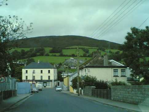
Baltinglass is set deep in the heart of Wicklow’s historic glens, and the sight of the imposing ruins of the Cistercian Abbey built above the bank of the River Slaney are testimony in stone to the fact that people settled here at an early period to farm the surrounding fertile land. But those who scale Baltinglass Hill looming above the village will be rewarded with much more than exceptional views. For close to the summit is evidence for the settlement of far earlier farmers in the area.

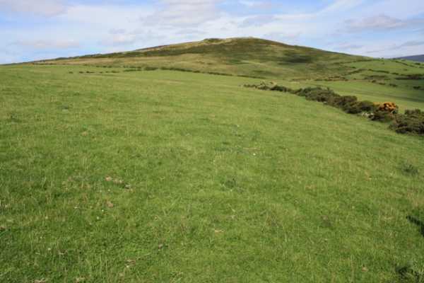
Parking is plentiful near the churchyard with its granite tower and a lane, shaded by trees hosting noisy rookeries which runs alongside, gives access to farmland. We pass across a couple of fields being grazed by sheep and cattle that are not perturbed by our presence. Eschewing the furze-choked cross, we head diagonally uphill to access croftland with large patches of unfurling bracken and a thin belt of easily traversed gorse at the top. The climb to this point is fairly steep, but the gradient eases as you pass into a large field used for grazing and the summit trig point looms into view. [ED: note this route is on private land and permission should be obtained before using it.]

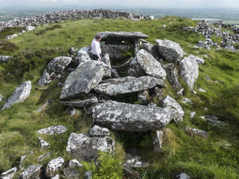
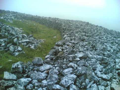
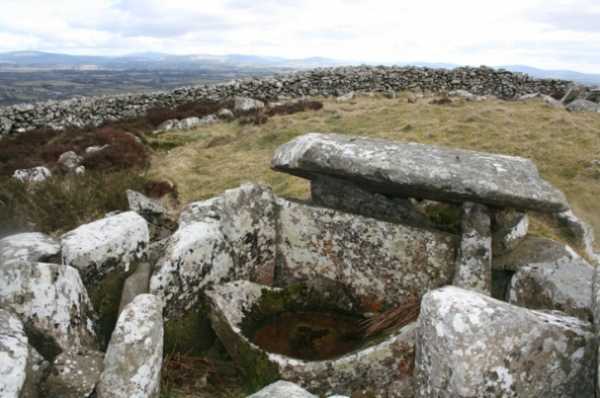
After crossing this field, the widely spaced double ramparts of Rathcoran Iron Age hill fort are encountered, cut through by a stone wall we'd just crossed. A bird’s eye view would see it hugging the heather clad contours below the summit to completely enclose it. At the summit is a much earlier badly damaged burial cairn 27m in diameter which has been robbed of its granite stone to build a protective wall around it and to demarcate the boundary of Baltinglass and Rathbran parishes. The cairn, possibly contemporaneous with Newgrange, comprises 3 passage-tombs clearly constructed over time as they partly overlie each other, and 2 single-chambered tombs. The northern tomb is the best preserved, comprising a short passage with some of its roof slabs intact, leading to a chamber with 3 shallow recesses containing a large basin stone with pecked ornament. The southern tomb is a jumble of fallen orthostats, some bearing the faint imprint of spiral art, while the western tomb has a collapsed corbelled roof with a barely visible passage.

The site was excavated in 1934-6 revealing evidence of the cremations of at least 3 adults and a child. Finds of carbonised hazelnuts, wheat grains and a saddle quern point to the extent of local climate change, affecting both the landscape cover and human settlement patterns. From 3,000-3,500 BC, the climate was drier and warmer, the glens were densely wooded, people lived much higher in the uplands and Neolithic farmers could cultivate arable crops above 1,000ft, on the slopes of hills like Baltinglass.

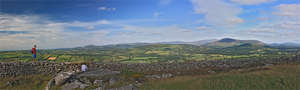
The sweeping vistas over the Wicklow and Blackstairs Mountains alone are worth the climb, but to ponder the purpose and meaning of this high place to our distant ancestors and how it connects with the megalithic structures dotting hillsides nearby, make Baltinglass Hill an absolute must. Linkback: mountainviews.ie/summit/864/comment/16101/
Read Less
Read More

            MountainViews.ie picture about Baltinglass Hill (<em>Cnoc Bhealach Conglais</em>)
Picture: Looking North from Baltinglass Hill.
At last, my 100th Local Summit
by simon3 12 Aug 2010
Sometime in 1969 or 70 I started climbing the Dublin and Wicklow Mountains, some of which are in what I would now call my Local 100.
I have climbed many of the higher ones many times and this year made a push on the more far-flung places such as Oriel Hill and Carrigroe. My final Local 100 was Baltinglass Hill which I enjoyed with two other veterans: madfrankie and wicklore. So having completed the challenge I now make a further claim: that of the slowest rate of climbing my local tops at around 2.5/ year. Beat that, young turks.
This panoramic view from the SW of the Wicklow Mountains shows Keadeen as the darker bump on the skyline about a quarter in from the right. Lugnaquillia is further away and just visible behind it. The apparently straight wall is that of the ringfort near the summit. The panoramic nature of the picture makes it appear straight, however in reality it is a circular enclosure. Linkback: mountainviews.ie/summit/864/comment/6004/
Read Less
Read More

            MountainViews.ie picture about Baltinglass Hill (<em>Cnoc Bhealach Conglais</em>)
Picture: View of Baltinglass Hill from the village.
wicklore on Baltinglass Hill
by wicklore 14 Sep 2008
As I drove around Baltinglass Hill looking for a likely approach point, I asked a farmer unloading sheep about access. He offered that I could park in his field and head up through his farmland. I said that I hoped to find a more public route, and he said that there was a lane beside the graveyard in Baltinglass that gave access onto the hill. He said it was ok to head up the hill that way. I found an overgrown track to the right of the graveyard at approximately A (S871 887). I followed this and in a few minutes entered the fields below Baltinglass Hill. I headed up towards a large cross and antennae at approx B (S878 892). I reached a field of painful gorse which stopped a direct uphill route, and much retracing of steps was needed to find a way through.
Reaching the cross I paused to look back down into Baltinglass and across to Tinoran Hill. Beyond the cross were more fields inhabited by cows, sheep and horses. I had to walk through them and I wondered if this was really the more public route the farmer had in mind.
The trig point of Baltinglass Hill was about another 700 metres beyond the cross. I enjoyed reaching it as I discovered the fascinating prehistoric hillfort there. The stone wall of the hillfort is a complete circle up to about 5 foot high in places. The wall itself is about 12 feet wide and I roughly measured the inside diameter at 60-70 feet. It is big! Within the circle are the remains of a few burial chambers. The weather was deteriorating rapidly and the views out to the east were disappearing. I just had time to say goodbye to Keadeen before she was engulfed in the rain clouds that would shortly reach me. To the south the Blackstairs were also cloud covered. In good weather I imagine this would be a fantastic viewpoint across the Wicklow hills.
There are no walker tracks and with the arrival of rain and cloud I used my compass to head back to the cross. I dropped down northwest to the road and walked back to my car.
I have no doubt that there are other routes available that don’t cross so much farmland. The forestry to the northwest of the summit might offer an approach. I would recommend that permission is sought every time before heading up from the graveyard side. Linkback: mountainviews.ie/summit/864/comment/3308/
Read Less
Read More

            MountainViews.ie picture about Baltinglass Hill (<em>Cnoc Bhealach Conglais</em>)
Picture: Part of the Hillfort on Baltinglass Hill
wicklore on Baltinglass Hill
by wicklore 14 Sep 2008
This photo shows a part of the huge intact hillfort beside the summit of Baltinglass Hill. I roughly measured the walls at 4-5 feet high, 12-15 feet thick and the interior diameter at 60-70 feet wide. The hillfort on nearby Tinoran Hill is almost buried, so this came as a huge surprise! Linkback: mountainviews.ie/summit/864/comment/3310/
Read Less
Read More

            MountainViews.ie picture about Baltinglass Hill (<em>Cnoc Bhealach Conglais</em>)
Picture: The passage grave
Dec_Alcock on Baltinglass Hill
by Dec_Alcock 11 Mar 2010
This is a view of the passage grave within the hill fort at the summit. Linkback: mountainviews.ie/summit/864/comment/4497/
Read Less
Read More
EDIT Point of Interest
text
Videos


Recent Contributions
x
Conditions and Info
Use of MountainViews is governed by conditions and a privacy policy.
Read general information about the site.
Opinions in material here are not necessarily endorsed by MountainViews.
Hillwalking is a risk sport. Information in comments, walks, shared GPS tracks or about starting places may not be accurate for example as regards safety or access permission. You are responsible for your safety and your permission to walk.
See the credits and list definitions.

OSi logo
OSNI/LPS logo
Open Street Map
(Various variations used.)
British summit data courtesy:
Database of British & Irish Hills