This website uses cookies, which are small text files that the website puts on your device to facilitate operation. Cookies help us provide a better service to you. They are used to track general user traffic information and to help the website function properly.
Feature count in area: 115, by county: Wicklow: 108, Kildare: 4, Wexford: 2, Carlow: 3, of which 1 is in both Wexford and Wicklow, of which 1 is in both Carlow and Wicklow,
OSI/LPS Maps: 28B, 55, 56, 61, 62, AWW, EW-DM, EW-LG, EW-WE, EW-WS
Highest Place: Lugnaquilla 924.7m
Starting Places (205) in area Wicklow: 1916 Memorial Car Park, Aghavannagh Ow Bridge, Aghowle Wood, Altidore Wood Entrance, Annacurra National School, Annalecka Bridge, Asbawn Brook L8350, Aughrim National School, Ballard Road, Ballinabarny Gap, Ballinagappoge Bridge Layby, Ballinagappoge Mountain Hairpin, Ballinagore, Ballinahinch Wood, Ballinastoe MBT CP, Ballinastraw South, Ballineddan Upr Fork, Ballinfoyle Upr Cross, Ballycoog, Ballycreen Brook Bridge, Ballycumber, Ballycumber Bridge, Ballycumber Lane, Ballycumber Wicklow Way, Ballylerane, Ballylow Bridge, Ballylusk Quarry, Ballymanus Lane, Ballymoyle Shooting Lodge, Ballynultagh Gap, Ballynultagh Lane, Ballyreagh Wood, Ballyross Forest, Ballysmuttan Long Stone, Baravore, Barnbawn South, Barranisky North, Barranisky West, Bohilla Land Roundabout, Bohilla Lane Mid, Boranaraltry Bridge, Bray Harbour, Brewel West, Brittas Bay North CP, Buckroney Sand Dunes CP, Bus Terminus, Camera Hill Track Cross, Castletimon Wood North, Clara Vale, Clone House Road, Clonegal, Cloon Wood Cp, Coate Bridge, Coolballintaggart Ledge, Coolbawn House Lane, Cransillagh Brook , Crone Wood CP, Crossbridge, Crossoona Rath, Cummer Wood South, Curtlestown Wood CP, Deputy's Pass CP, Derralossary Church, Derry River Bridge, Devil's Glen CP, Devil's Glen Wood, Djouce Wood Calary, Djouce Wood Lake, Djouce Wood Long Hill, Donard, Donnelly's Lane Car Sales, Drumgoff Forest, Dunranhill North, Dunranhill SE, Dunranhill South, Dwyer McAllister Cottage CP, Enniskerry, Fentons Pub, Fitzsimons Park GAA, unuseableFlemings Footbridge Glen Rd, Gap Pub, Gap Road, Glen Beach CP, Glen of the Downs CP, Glenbride Lane, Glenbride Lodge, Glencree Reconciliation, Glendalough, Glenealy GAA, Glenmacnass Tonelagee CP, Glenmalure Hostel, Glenmalure Lodge, Glenmalure Waterfall, Glenview Hotel, Gowle House, Great Sugar Loaf CP, Grove Bar, Heffernans Well Wood, Hill View, Hollywood Glen, JB Malone CP, Johnnie Fox Pub, Keadeen NE trail, Keadeen Trailhead, Kevins Way Footbridge, Kilbride Army Camp Entrance, Kilcandra South, Kilcommon View, Killalongford Wood, Kilmacrea Cross Roads, Kilranelagh House Gate, Kilruddery Car Park, Kilruddery Cottages, Kings River, Kippure Bridge, Kippure Estate, Kippure Transmitter Gate, Knickeen Cross, Knocknaboley Lane Leeraghs Bog, Knocknaboley Lane Stone Cottage, Knockrath Little, Knockree west, Kyle Loop North, Lackan Wood S, Lake Dr Fraughan Brook, Lake Drive, Lake Park Cross, Lake View Pub, Laragh Free Car Park, Laragh NSch, Lead Mines CP, Liffey Bridge, Liffey Head Bridge, Lough Bray Lower, Lough Bray Upper, Lough Tay North Viewing Point, Lough Tay Wicklow Way CP, Luglass Lane L97561, Lugnagun Track, Macreddin Village, Mangans Lane, Military Road Carrigshouk Hill, Military Road Inchavore River Nth, Military Road Inchavore River Sth, Military Road NW Lough Tay, Military Road Ballyboy Bridge, Military Road Cloghoge Brook, Military Road Croaghanmoira, Military Road Fananierin, Military Road LaraghWicklow Way, Military Road Slieve Maan, Monspolien Bridge, Moortown House, Mountain Rescue HQ, Muskeagh Little Wood, Nahanagan Lough NE, Novara Avenue, Bray, Oiltiagh Brook Knickeen, Old Bridge Cross, Old Bridge Scouts , Old Wicklow Way entrance, Paddock Hill SE, Pier Gates CP, Powerscourt Waterfall CP, Putland Road, Quintagh East, Raheen Park CP, Raheenleagh East, Railway Walk CP, Rathdrum Railway Station, Rednagh Wood, Rocky Valley, Roundwood, Sally Gap, Sally Gap N, Seefin Trailhead, Seskin SE, Shankill Tributary Bridge, Shay Elliott, Sheepshanks Bridge, Shillelagh, Slievecorragh Track, Slievefoore South, Sraghoe Brook, St John's Church, St Kevins Chair, St Kevins Church, St Kevins Way R756, Stone Circle Bridge, Stookeen South, Stranahely Wood, Stranakelly Cross Roads, Tallyho, Templeboden, Tithewer, Tomcoyle L, Tomriland Wood, Toor Brook, Trooperstown Hill Access, Turlough Hill CP, Upper Lake CP, Vallymount GAA CP, Vartry Reservoir Upper, Zellers Pub
Summits & other features in area Wicklow: Cen: Glendalough North: Brockagh Mountain 556.9m, Brockagh Mountain NW Top 549.5m, Brockagh Mountain SE Top 471.7m, Camaderry East Top 677.3m, Camaderry Mountain 698.6m, Conavalla 734m, Tomaneena 682.4m Cen: Glendalough South: Carriglineen Mountain 456.6m, Cullentragh Mountain 510m, Derrybawn Mountain 476.1m, Kirikee Mountain 474.5m, Lugduff 653.2m, Lugduff SE Top 638m, Mullacor 660.7m, Trooperstown Hill 430m N Cen: Tonelagee: Carrignagunneen 561m, Fair Mountain 571.2m, Stoney Top 713.7m, Tonelagee 815.8m, Tonelagee E Top 668m, Tonelagee South-East Top 545.8m NE: Bray & Kilmacanogue: Bray Head Hill 238.9m, Carrigoona Commons East 242m, Downs Hill 372.9m, Great Sugar Loaf 501.2m, Little Sugar Loaf 342.4m NE: Djouce: Djouce 725.5m, Knockree 342.1m, Maulin 570m, Tonduff 642m, Tonduff East Top 593m, War Hill 684.8m, White Hill 631.1m NE: Fancy: Ballinafunshoge 480m, Kanturk 527.4m, Knocknacloghoge 532.4m, Luggala 593.3m, Robber's Pass Hill 508.9m, Scarr 640m, Scarr North-West Top 559.8m, Sleamaine 430m NE: Vartry: Ballinacorbeg 336m, Ballycurry 301m, Dunranhill 342m, Mount Kennedy 365.9m NW: Blessington: Carrigleitrim 408m, Lugnagun 446.2m, Slieveroe 332m, Sorrel Hill 599.5m NW: Mullaghcleevaun: Black Hill 602.2m, Carrigshouk 572.5m, Carrigvore 682.4m, Duff Hill 720.8m, Gravale 719m, Moanbane 703m, Mullaghcleevaun 846.7m, Mullaghcleevaun East Top 796m, Silsean 698m S: Aughrim Hills: Cushbawn 400m, Killeagh 249m, Moneyteige North 427m, Preban Hill 389m S: Croaghanmoira: Ballinacor Mountain 529.3m, Ballycurragh Hill 536m, Ballyteige 447m, Carrickashane Mountain 508m, Croaghanmoira 662.3m, Croaghanmoira North Top 579.5m, Fananierin 426m, Slieve Maan 547.8m, Slieve Maan North Top 546.1m S: Croghan Kinsella: Annagh Hill 454m, Croghan Kinsella 606m, Croghan Kinsella East Top 562.1m, Slievefoore 414m S: Shillelagh Hills: Lakeen 357m, Monaughrim 206m, Seskin 344m, Stookeen 420m S: Tinahely Hills: Ballycumber Hill 429.7m, Eagle Hill 296m, Muskeagh Hill 398.2m SE: Wicklow South East: Ballinastraw 284m, Ballyguile Hill 188m, Barranisky 280m, Carrick Mountain 381m, Collon Hill 238m, Kilnamanagh Hill 217m, Westaston Hill 270m W: Baltinglass: Ballyhook Hill 288m, Baltinglass Hill 382m, Carrig Mountain 571m, Carrigeen Hill 298m, Cloghnagaune 385m, Corballis Hill 258m, Keadeen Mountain 653m, Spinans Hill 409m, Spinans Hill SE Top 400m, Tinoran Hill 312m W: Cen Lugnaquilla: Ballineddan Mountain 652.3m, Benleagh 689m, Camenabologue 758m, Camenabologue SE Top 663m, Cloghernagh 800m, Corrigasleggaun 794.6m, Lugnaquilla 924.7m, Slievemaan 759.7m W: Donard: Brewel Hill 222m, Church Mountain 544m, Corriebracks 531m, Lobawn 636m, Slievecorragh 418m, Sugarloaf 552m, Table Mountain 701.7m, Table Mountain West Top 563m
Note: this list of places may include island features such as summits, but not
islands as such.
Tonelagee South-East Top, 545.8mMountain Tóin le Gaoith (mullach thoir theas) A name in Irish,
Place Rating ..
For origin of name, see Tonelagee., Wicklow County in Leinster province, in Arderin Beg Lists, Tonelagee South-East Top is the 432nd highest place in Ireland.
Grid Reference O09982 00414,
OS 1:50k mapsheet 56 Place visited by: 196members, recently by: davidrenshaw, maoris, Lidia27, Magic, Carolineswalsh, Alanjm, konrad, MickM45, NualaB, Mark1, muddypaws, bandre, JohnHoare, Kaszmirek78, moggy40
I visited this place: NO (You need to be a logged-in member for this.)
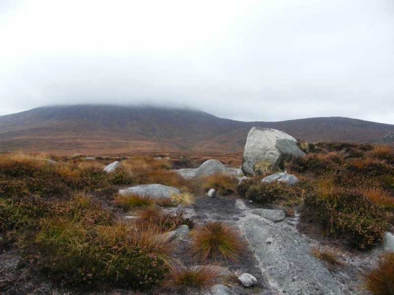
Choose mountains, choose Tonlagee SE Top, choose to do a loop from Brockagh Mtn to Stoney Top and bag a few hills at the same time, choose to walk along the boggy summit ridge. Not me. I chose to start at A (T09255 99958). I chose to leave my car in a layby and bag only 2 hills. I chose to snap a boulder at the summit area with Tonlagee in the background. I chose up and down in an hour and a half. Choose your boulder, choose your route, choose mountains! Linkback: mountainviews.ie/summit/1447/comment/18355/
Read Less
Read More
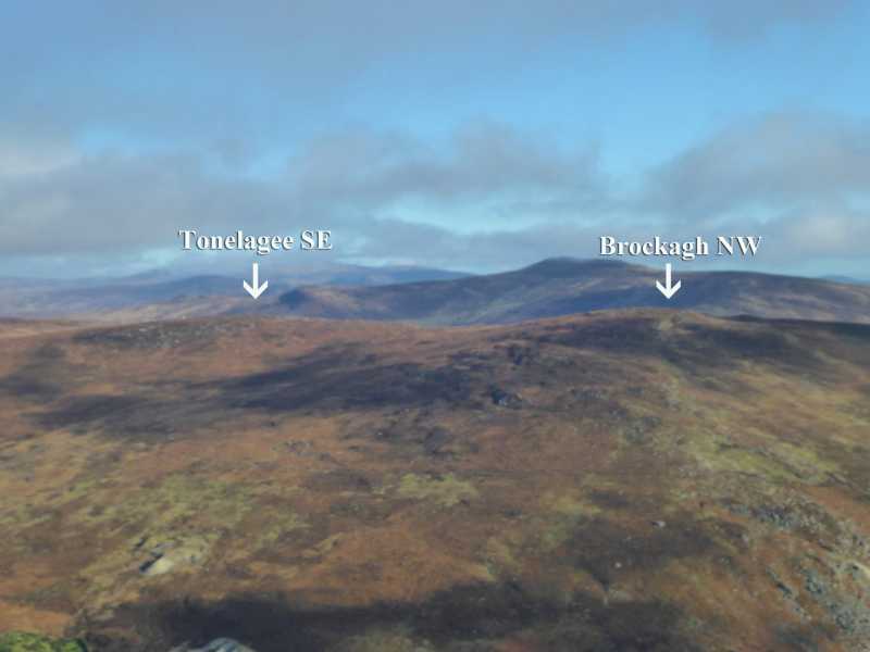
Picture: The two Arderin Begs as seen from Camaderry SE top
Uninspiring bump
by Colin Murphy
27 Oct 2017
The Arderin Beg has the benefit of being just a ten minute walk from another - Brockagh NW - so you can kill two birds with one stone, so to speak. Other than that it is a truly uninspiring bump in the landscape with no marking at the top. I parked at Point A, as suggested by paddyhillsbagger and walked directly towards the top in a NE direction. It's a gentle enough slope to start with, with shortish grass, and was pretty firm underfoot. But around 400m elevation you hit the heather and after having stumbled into concealed holes about five times, the knee-high heather began to sap my will to live! It also gets a bit steeper the higher you go. At the top, it is difficult to discern the high point and there are three possible options - my GPS suggested the one furthest to the NE was highest by about 3m. 40 minutes from car to top. Linkback: mountainviews.ie/summit/1447/comment/19772/
Read Less
Read More
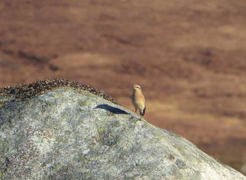
Picture: Bird's eye view
The birds and the bees
by Colin Murphy
20 Nov 2017
Boring summit it may be, but around the summit area I was heartened by the sound of much birdsong and every few steps birds would explode from the heather or from behind a rock - one or two of them quite large and fast.The area seems to be a favoured spot for our feathered friends for some reason. Unfortunately my ornithological knowledge is limited to what I can see in my back garden. There was also quite a number of bees buzzing around my head and I had to fight a few off while I ate my lunch. Maybe it was the fine, still weather or the time of year, but the place is alive with winged creatures big and small. Linkback: mountainviews.ie/summit/1447/comment/19773/
Use of MountainViews is governed by conditions and a privacy policy.
Read general information about the site. Opinions in material here are not necessarily endorsed by MountainViews.
Hillwalking is a risk sport. Information in comments, walks, shared GPS tracks or about starting places may
not be accurate for example as regards safety or access permission. You are responsible for your safety and your permission to walk.
See the credits and list definitions.


 Our Facebook page.