Cookies.
This website uses cookies, which are small text files that the website puts on your device to facilitate operation. Cookies help us provide a better service to you. They are used to track general user traffic information and to help the website function properly.
Features
Nearby features appear when you click the map.
Declutter tracks on map.
Place Search
Video
X
Pub: by
Wicklow Area , SE: Wicklow South East Subarea
Feature count in area: 115, by county: Wicklow: 108, Kildare: 4, Wexford: 2, Carlow: 3, of which 1 is in both Wexford and Wicklow, of which 1 is in both Carlow and Wicklow, OSI/LPS Maps: 28B, 55, 56, 61, 62, AWW, EW-DM, EW-LG, EW-WE, EW-WS
Highest Place: Lugnaquilla 924.7m

Starting Places (205) in area Wicklow:
1916 Memorial Car Park, Aghavannagh Ow Bridge, Aghowle Wood, Altidore Wood Entrance, Annacurra National School, Annalecka Bridge, Asbawn Brook L8350, Aughrim National School, Ballard Road, Ballinabarny Gap, Ballinagappoge Bridge Layby, Ballinagappoge Mountain Hairpin, Ballinagore, Ballinahinch Wood, Ballinastoe MBT CP, Ballinastraw South, Ballineddan Upr Fork, Ballinfoyle Upr Cross, Ballycoog, Ballycreen Brook Bridge, Ballycumber, Ballycumber Bridge, Ballycumber Lane, Ballycumber Wicklow Way, Ballylerane, Ballylow Bridge, Ballylusk Quarry, Ballymanus Lane, Ballymoyle Shooting Lodge, Ballynultagh Gap, Ballynultagh Lane, Ballyreagh Wood, Ballyross Forest, Ballysmuttan Long Stone, Baravore, Barnbawn South, Barranisky North, Barranisky West, Bohilla Land Roundabout, Bohilla Lane Mid, Boranaraltry Bridge, Bray Harbour, Brewel West, Brittas Bay North CP, Buckroney Sand Dunes CP, Bus Terminus, Camera Hill Track Cross, Castletimon Wood North, Clara Vale, Clone House Road, Clonegal, Cloon Wood Cp, Coate Bridge, Coolballintaggart Ledge, Coolbawn House Lane, Cransillagh Brook , Crone Wood CP, Crossbridge, Crossoona Rath, Cummer Wood South, Curtlestown Wood CP, Deputy's Pass CP, Derralossary Church, Derry River Bridge, Devil's Glen CP, Devil's Glen Wood, Djouce Wood Calary, Djouce Wood Lake, Djouce Wood Long Hill, Donard, Donnelly's Lane Car Sales, Drumgoff Forest, Dunranhill North, Dunranhill SE, Dunranhill South, Dwyer McAllister Cottage CP, Enniskerry, Fentons Pub, Fitzsimons Park GAA, unuseableFlemings Footbridge Glen Rd, Gap Pub, Gap Road, Glen Beach CP, Glen of the Downs CP, Glenbride Lane, Glenbride Lodge, Glencree Reconciliation, Glendalough, Glenealy GAA, Glenmacnass Tonelagee CP, Glenmalure Hostel, Glenmalure Lodge, Glenmalure Waterfall, Glenview Hotel, Gowle House, Great Sugar Loaf CP, Grove Bar, Heffernans Well Wood, Hill View, Hollywood Glen, JB Malone CP, Johnnie Fox Pub, Keadeen NE trail, Keadeen Trailhead, Kevins Way Footbridge, Kilbride Army Camp Entrance, Kilcandra South, Kilcommon View, Killalongford Wood, Kilmacrea Cross Roads, Kilranelagh House Gate, Kilruddery Car Park, Kilruddery Cottages, Kings River, Kippure Bridge, Kippure Estate, Kippure Transmitter Gate, Knickeen Cross, Knocknaboley Lane Leeraghs Bog, Knocknaboley Lane Stone Cottage, Knockrath Little, Knockree west, Kyle Loop North, Lackan Wood S, Lake Dr Fraughan Brook, Lake Drive, Lake Park Cross, Lake View Pub, Laragh Free Car Park, Laragh NSch, Lead Mines CP, Liffey Bridge, Liffey Head Bridge, Lough Bray Lower, Lough Bray Upper, Lough Tay North Viewing Point, Lough Tay Wicklow Way CP, Luglass Lane L97561, Lugnagun Track, Macreddin Village, Mangans Lane, Military Road Carrigshouk Hill, Military Road Inchavore River Nth, Military Road Inchavore River Sth, Military Road NW Lough Tay, Military Road Ballyboy Bridge, Military Road Cloghoge Brook, Military Road Croaghanmoira, Military Road Fananierin, Military Road LaraghWicklow Way, Military Road Slieve Maan, Monspolien Bridge, Moortown House, Mountain Rescue HQ, Muskeagh Little Wood, Nahanagan Lough NE, Novara Avenue, Bray, Oiltiagh Brook Knickeen, Old Bridge Cross, Old Bridge Scouts , Old Wicklow Way entrance, Paddock Hill SE, Pier Gates CP, Powerscourt Waterfall CP, Putland Road, Quintagh East, Raheen Park CP, Raheenleagh East, Railway Walk CP, Rathdrum Railway Station, Rednagh Wood, Rocky Valley, Roundwood, Sally Gap, Sally Gap N, Seefin Trailhead, Seskin SE, Shankill Tributary Bridge, Shay Elliott, Sheepshanks Bridge, Shillelagh, Slievecorragh Track, Slievefoore South, Sraghoe Brook, St John's Church, St Kevins Chair, St Kevins Church, St Kevins Way R756, Stone Circle Bridge, Stookeen South, Stranahely Wood, Stranakelly Cross Roads, Tallyho, Templeboden, Tithewer, Tomcoyle L, Tomriland Wood, Toor Brook, Trooperstown Hill Access, Turlough Hill CP, Upper Lake CP, Vallymount GAA CP, Vartry Reservoir Upper, Zellers Pub

Summits & other features in area Wicklow:
Cen: Glendalough North: Brockagh Mountain 556.9m, Brockagh Mountain NW Top 549.5m, Brockagh Mountain SE Top 471.7m, Camaderry East Top 677.3m, Camaderry Mountain 698.6m, Conavalla 734m, Tomaneena 682.4m
Cen: Glendalough South: Carriglineen Mountain 456.6m, Cullentragh Mountain 510m, Derrybawn Mountain 476.1m, Kirikee Mountain 474.5m, Lugduff 653.2m, Lugduff SE Top 638m, Mullacor 660.7m, Trooperstown Hill 430m
N Cen: Tonelagee: Carrignagunneen 561m, Fair Mountain 571.2m, Stoney Top 713.7m, Tonelagee 815.8m, Tonelagee E Top 668m, Tonelagee South-East Top 545.8m
NE: Bray & Kilmacanogue: Bray Head Hill 238.9m, Carrigoona Commons East 242m, Downs Hill 372.9m, Great Sugar Loaf 501.2m, Little Sugar Loaf 342.4m
NE: Djouce: Djouce 725.5m, Knockree 342.1m, Maulin 570m, Tonduff 642m, Tonduff East Top 593m, War Hill 684.8m, White Hill 631.1m
NE: Fancy: Ballinafunshoge 480m, Kanturk 527.4m, Knocknacloghoge 532.4m, Luggala 593.3m, Robber's Pass Hill 508.9m, Scarr 640m, Scarr North-West Top 559.8m, Sleamaine 430m
NE: Vartry: Ballinacorbeg 336m, Ballycurry 301m, Dunranhill 342m, Mount Kennedy 365.9m
NW: Blessington: Carrigleitrim 408m, Lugnagun 446.2m, Slieveroe 332m, Sorrel Hill 599.5m
NW: Mullaghcleevaun: Black Hill 602.2m, Carrigshouk 572.5m, Carrigvore 682.4m, Duff Hill 720.8m, Gravale 719m, Moanbane 703m, Mullaghcleevaun 846.7m, Mullaghcleevaun East Top 796m, Silsean 698m
S: Aughrim Hills: Cushbawn 400m, Killeagh 249m, Moneyteige North 427m, Preban Hill 389m
S: Croaghanmoira: Ballinacor Mountain 529.3m, Ballycurragh Hill 536m, Ballyteige 447m, Carrickashane Mountain 508m, Croaghanmoira 662.3m, Croaghanmoira North Top 579.5m, Fananierin 426m, Slieve Maan 547.8m, Slieve Maan North Top 546.1m
S: Croghan Kinsella: Annagh Hill 454m, Croghan Kinsella 606m, Croghan Kinsella East Top 562.1m, Slievefoore 414m
S: Shillelagh Hills: Lakeen 357m, Monaughrim 206m, Seskin 344m, Stookeen 420m
S: Tinahely Hills: Ballycumber Hill 429.7m, Eagle Hill 296m, Muskeagh Hill 398.2m
SE: Wicklow South East: Ballinastraw 284m, Ballyguile Hill 188m, Barranisky 280m, Carrick Mountain 381m, Collon Hill 238m, Kilnamanagh Hill 217m, Westaston Hill 270m
W: Baltinglass: Ballyhook Hill 288m, Baltinglass Hill 382m, Carrig Mountain 571m, Carrigeen Hill 298m, Cloghnagaune 385m, Corballis Hill 258m, Keadeen Mountain 653m, Spinans Hill 409m, Spinans Hill SE Top 400m, Tinoran Hill 312m
W: Cen Lugnaquilla: Ballineddan Mountain 652.3m, Benleagh 689m, Camenabologue 758m, Camenabologue SE Top 663m, Cloghernagh 800m, Corrigasleggaun 794.6m, Lugnaquilla 924.7m, Slievemaan 759.7m
W: Donard: Brewel Hill 222m, Church Mountain 544m, Corriebracks 531m, Lobawn 636m, Slievecorragh 418m, Sugarloaf 552m, Table Mountain 701.7m, Table Mountain West Top 563m

Note: this list of places may include island features such as summits, but not islands as such.
Rating graphic.
Westaston Hill, 270m Hill
Place Rating ..
, Bola Hill, Wicklow County in Leinster province, in Binnion Lists, Westaston Hill is the 1235th highest place in Ireland.
Grid Reference T23720 87226, OS 1:50k mapsheet 62
Place visited by: 37 members, recently by: nupat, NualaB, hibby, michaelseaver, Pepe, briankelly, childminder05, Beti13, abcd, srr45, loftyobrien, annem, Glanman2, mountainmike, conormcbandon
I visited this place: NO (You need to be a logged-in member for this.)
Longitude: -6.161266, Latitude: 52.921943, Easting: 323720, Northing: 187226, Prominence: 122m,  Isolation: 3.8km
ITM: 723641 687262
Bedrock type: Diorite, (Diorite)

  Short or GPS IDs, 6 char: WstsHl, 10 char: WststnHil

Linkback: https://mountainviews.ie/summit/1190/
Gallery for Westaston Hill and surrounds
Summary for Westaston Hill : Unremarkable top surmounted by tall comms tower
Summary created by Colin Murphy 2019-07-02 13:47:06
            MountainViews.ie picture about Westaston Hill
Picture: View west from ascending track
Parking for a couple of cars at K'creaX (T23362 86056). Follow track for about 1km to A (T23477 86889) where the track forks. Take the right track and continue along here for a about 200m to communications mast, which is as close as is feasibly possible to get to the highest point, given the dense tree and briar covering.
Linkback: mountainviews.ie/summit/1190/comment/15434/
Member Comments for Westaston Hill
Comment create / edit display placeholder

            MountainViews.ie picture about Westaston Hill
Picture: View to the north east over arboretum.
Puzzles of the hill.
by simon3 3 Nov 2014
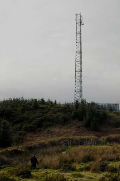
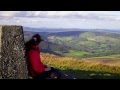
The first puzzle of this hill is "Where is the top". Given the current covering in Sitka Spruce with razor wire briers I can't see any onsite determination of this at present and I am not so sure even modern technology like photogrammetry or lidar would do any better. So I think that considering the top to be beside the communications tower is unlikely to be disputable until the trees are mature or cut.

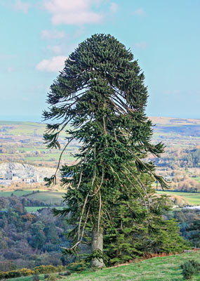
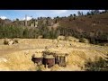
A second puzzle are some of the trees nearby such as the one shown in the picture here. This and another are Chilean Pines, usually better known as Monkey Puzzles.

In fact Westaston Hill is the high end of an arboretum originally started by a line of Cromwellian settlers called Acton. This is now operated as Kilmacurragh Botanic Gardens by the OPW. Here's what they have to say about the monkey-puzzles on Westaston Hill:

"Tom Acton had a rule of thumb to plant three of every important tree or shrub. One was planted where visiting plantsmen told him it would thrive, another where he thought it would survive, and the last where it would unquestionably not survive. Examples of the latter may be seen on the brow of Westaston Hill that overlooks the house and estate. To this day, a line of exotics, like Himalayan rhododendrons, mighty North American conifers and Chilean trees, all planted by Tom Acton’s gardeners, still grow on this wind swept site. Most are in ragged order and battered because of their exposed positions – except for two fine monkey puzzles. This tree inhabits the high Andes of Chile where it is exposed to the same raging winds. In this case, a tree planted in a situation where he was told it would positively not grow, did survive, indeed it thrived."

Take a look if you visit Westaston, these trees are magnificent.

More at http://www.botanicgardens.ie/kilmac/kilmhist.htm Linkback: mountainviews.ie/summit/1190/comment/17739/
Read Less
Read More

            MountainViews.ie picture about Westaston Hill
Picture: At the (possible) summit of Westaston Hill
Unspectacular but pleasant Sunday walk
by hibby 11 Feb 2024
Westaston Hill is one of a number of hills on my Local 100 that I had never previously heard of, and likely would never have climbed were it not for the list.

This morning we were blessed with glorious sunny February weather for the short ascent. Parked at the recommended spot K'creaX (T23362 86056) and followed the track up. Largely uneventful and gradual ascent on forest tracks, ground firm and even underfoot. The only obstacle to be negotiated was a pair of fallen trees blocking the full width of the track just after the fork at A (T23477 86889).

Arriving at the communication mast, we found that the trees have matured to the stage that it's possible to enter the forest without getting scratched up. One possible candidate for the high point is at B (T23697 87180) where there is a "lump" about 3 metres higher than the surrounding forest floor.

Total walking distance/time (including exploring the forest in search of the high point): 4 km/50 mins. Linkback: mountainviews.ie/summit/1190/comment/24126/
Read Less
Read More

            MountainViews.ie picture about Westaston Hill
Picture: Mastaston?
Another Mast
by eamonoc 22 Feb 2014
Climbed on 21/2/2014. Had a bit of difficulty navigating to the start point as there were some road closures hereabouts. Eventually made it to K'creaX (T23362 86056), followed main forest track to point A (T23477 86889) took right fork here and followed track up to communications mast. Nice views east towards Brittas Bay. Linkback: mountainviews.ie/summit/1190/comment/15872/
Read Less
Read More

            MountainViews.ie picture about Westaston Hill
Picture: Summit Area
Sliced and Diced.
by sandman 8 May 2014
If you go out in the woods today be sure of a supprise when you reach the mast on this hill as the summit is app 65 meters opposite in the dense jungle so you have a choice wait till the trees are felled or prepair to be sliced and diced. Linkback: mountainviews.ie/summit/1190/comment/16058/
Read Less
Read More

The top?
by Barry 23 Sep 2017
I think the highest point is likely about 175 metres in a WSW direction from the mast. I'm judging this from aerial photography and DTM which shows a rocky outcrop in a small forest clearing. DTM gives a reading of about 270.5m on this outcrop with a figure of c.268m near mast. Could be some distortion in heights due to tree cover. Linkback: mountainviews.ie/summit/1190/comment/19731/
Read Less
Read More
EDIT Point of Interest
text
Videos


Recent Contributions
x
Conditions and Info
Use of MountainViews is governed by conditions and a privacy policy.
Read general information about the site.
Opinions in material here are not necessarily endorsed by MountainViews.
Hillwalking is a risk sport. Information in comments, walks, shared GPS tracks or about starting places may not be accurate for example as regards safety or access permission. You are responsible for your safety and your permission to walk.
See the credits and list definitions.

OSi logo
OSNI/LPS logo
Open Street Map
(Various variations used.)
British summit data courtesy:
Database of British & Irish Hills