Cookies.
This website uses cookies, which are small text files that the website puts on your device to facilitate operation. Cookies help us provide a better service to you. They are used to track general user traffic information and to help the website function properly.
Features
Nearby features appear when you click the map.
Declutter tracks on map.
Place Search
Video
X
Pub: by
Wicklow Area , NE: Fancy Subarea
Feature count in area: 115, by county: Wicklow: 108, Kildare: 4, Wexford: 2, Carlow: 3, of which 1 is in both Wexford and Wicklow, of which 1 is in both Carlow and Wicklow, OSI/LPS Maps: 28B, 55, 56, 61, 62, AWW, EW-DM, EW-LG, EW-WE, EW-WS
Highest Place: Lugnaquilla 924.7m

Starting Places (205) in area Wicklow:
1916 Memorial Car Park, Aghavannagh Ow Bridge, Aghowle Wood, Altidore Wood Entrance, Annacurra National School, Annalecka Bridge, Asbawn Brook L8350, Aughrim National School, Ballard Road, Ballinabarny Gap, Ballinagappoge Bridge Layby, Ballinagappoge Mountain Hairpin, Ballinagore, Ballinahinch Wood, Ballinastoe MBT CP, Ballinastraw South, Ballineddan Upr Fork, Ballinfoyle Upr Cross, Ballycoog, Ballycreen Brook Bridge, Ballycumber, Ballycumber Bridge, Ballycumber Lane, Ballycumber Wicklow Way, Ballylerane, Ballylow Bridge, Ballylusk Quarry, Ballymanus Lane, Ballymoyle Shooting Lodge, Ballynultagh Gap, Ballynultagh Lane, Ballyreagh Wood, Ballyross Forest, Ballysmuttan Long Stone, Baravore, Barnbawn South, Barranisky North, Barranisky West, Bohilla Land Roundabout, Bohilla Lane Mid, Boranaraltry Bridge, Bray Harbour, Brewel West, Brittas Bay North CP, Buckroney Sand Dunes CP, Bus Terminus, Camera Hill Track Cross, Castletimon Wood North, Clara Vale, Clone House Road, Clonegal, Cloon Wood Cp, Coate Bridge, Coolballintaggart Ledge, Coolbawn House Lane, Cransillagh Brook , Crone Wood CP, Crossbridge, Crossoona Rath, Cummer Wood South, Curtlestown Wood CP, Deputy's Pass CP, Derralossary Church, Derry River Bridge, Devil's Glen CP, Devil's Glen Wood, Djouce Wood Calary, Djouce Wood Lake, Djouce Wood Long Hill, Donard, Donnelly's Lane Car Sales, Drumgoff Forest, Dunranhill North, Dunranhill SE, Dunranhill South, Dwyer McAllister Cottage CP, Enniskerry, Fentons Pub, Fitzsimons Park GAA, unuseableFlemings Footbridge Glen Rd, Gap Pub, Gap Road, Glen Beach CP, Glen of the Downs CP, Glenbride Lane, Glenbride Lodge, Glencree Reconciliation, Glendalough, Glenealy GAA, Glenmacnass Tonelagee CP, Glenmalure Hostel, Glenmalure Lodge, Glenmalure Waterfall, Glenview Hotel, Gowle House, Great Sugar Loaf CP, Grove Bar, Heffernans Well Wood, Hill View, Hollywood Glen, JB Malone CP, Johnnie Fox Pub, Keadeen NE trail, Keadeen Trailhead, Kevins Way Footbridge, Kilbride Army Camp Entrance, Kilcandra South, Kilcommon View, Killalongford Wood, Kilmacrea Cross Roads, Kilranelagh House Gate, Kilruddery Car Park, Kilruddery Cottages, Kings River, Kippure Bridge, Kippure Estate, Kippure Transmitter Gate, Knickeen Cross, Knocknaboley Lane Leeraghs Bog, Knocknaboley Lane Stone Cottage, Knockrath Little, Knockree west, Kyle Loop North, Lackan Wood S, Lake Dr Fraughan Brook, Lake Drive, Lake Park Cross, Lake View Pub, Laragh Free Car Park, Laragh NSch, Lead Mines CP, Liffey Bridge, Liffey Head Bridge, Lough Bray Lower, Lough Bray Upper, Lough Tay North Viewing Point, Lough Tay Wicklow Way CP, Luglass Lane L97561, Lugnagun Track, Macreddin Village, Mangans Lane, Military Road Carrigshouk Hill, Military Road Inchavore River Nth, Military Road Inchavore River Sth, Military Road NW Lough Tay, Military Road Ballyboy Bridge, Military Road Cloghoge Brook, Military Road Croaghanmoira, Military Road Fananierin, Military Road LaraghWicklow Way, Military Road Slieve Maan, Monspolien Bridge, Moortown House, Mountain Rescue HQ, Muskeagh Little Wood, Nahanagan Lough NE, Novara Avenue, Bray, Oiltiagh Brook Knickeen, Old Bridge Cross, Old Bridge Scouts , Old Wicklow Way entrance, Paddock Hill SE, Pier Gates CP, Powerscourt Waterfall CP, Putland Road, Quintagh East, Raheen Park CP, Raheenleagh East, Railway Walk CP, Rathdrum Railway Station, Rednagh Wood, Rocky Valley, Roundwood, Sally Gap, Sally Gap N, Seefin Trailhead, Seskin SE, Shankill Tributary Bridge, Shay Elliott, Sheepshanks Bridge, Shillelagh, Slievecorragh Track, Slievefoore South, Sraghoe Brook, St John's Church, St Kevins Chair, St Kevins Church, St Kevins Way R756, Stone Circle Bridge, Stookeen South, Stranahely Wood, Stranakelly Cross Roads, Tallyho, Templeboden, Tithewer, Tomcoyle L, Tomriland Wood, Toor Brook, Trooperstown Hill Access, Turlough Hill CP, Upper Lake CP, Vallymount GAA CP, Vartry Reservoir Upper, Zellers Pub

Summits & other features in area Wicklow:
Cen: Glendalough North: Brockagh Mountain 556.9m, Brockagh Mountain NW Top 549.5m, Brockagh Mountain SE Top 471.7m, Camaderry East Top 677.3m, Camaderry Mountain 698.6m, Conavalla 734m, Tomaneena 682.4m
Cen: Glendalough South: Carriglineen Mountain 456.6m, Cullentragh Mountain 510m, Derrybawn Mountain 476.1m, Kirikee Mountain 474.5m, Lugduff 653.2m, Lugduff SE Top 638m, Mullacor 660.7m, Trooperstown Hill 430m
N Cen: Tonelagee: Carrignagunneen 561m, Fair Mountain 571.2m, Stoney Top 713.7m, Tonelagee 815.8m, Tonelagee E Top 668m, Tonelagee South-East Top 545.8m
NE: Bray & Kilmacanogue: Bray Head Hill 238.9m, Carrigoona Commons East 242m, Downs Hill 372.9m, Great Sugar Loaf 501.2m, Little Sugar Loaf 342.4m
NE: Djouce: Djouce 725.5m, Knockree 342.1m, Maulin 570m, Tonduff 642m, Tonduff East Top 593m, War Hill 684.8m, White Hill 631.1m
NE: Fancy: Ballinafunshoge 480m, Kanturk 527.4m, Knocknacloghoge 532.4m, Luggala 593.3m, Robber's Pass Hill 508.9m, Scarr 640m, Scarr North-West Top 559.8m, Sleamaine 430m
NE: Vartry: Ballinacorbeg 336m, Ballycurry 301m, Dunranhill 342m, Mount Kennedy 365.9m
NW: Blessington: Carrigleitrim 408m, Lugnagun 446.2m, Slieveroe 332m, Sorrel Hill 599.5m
NW: Mullaghcleevaun: Black Hill 602.2m, Carrigshouk 572.5m, Carrigvore 682.4m, Duff Hill 720.8m, Gravale 719m, Moanbane 703m, Mullaghcleevaun 846.7m, Mullaghcleevaun East Top 796m, Silsean 698m
S: Aughrim Hills: Cushbawn 400m, Killeagh 249m, Moneyteige North 427m, Preban Hill 389m
S: Croaghanmoira: Ballinacor Mountain 529.3m, Ballycurragh Hill 536m, Ballyteige 447m, Carrickashane Mountain 508m, Croaghanmoira 662.3m, Croaghanmoira North Top 579.5m, Fananierin 426m, Slieve Maan 547.8m, Slieve Maan North Top 546.1m
S: Croghan Kinsella: Annagh Hill 454m, Croghan Kinsella 606m, Croghan Kinsella East Top 562.1m, Slievefoore 414m
S: Shillelagh Hills: Lakeen 357m, Monaughrim 206m, Seskin 344m, Stookeen 420m
S: Tinahely Hills: Ballycumber Hill 429.7m, Eagle Hill 296m, Muskeagh Hill 398.2m
SE: Wicklow South East: Ballinastraw 284m, Ballyguile Hill 188m, Barranisky 280m, Carrick Mountain 381m, Collon Hill 238m, Kilnamanagh Hill 217m, Westaston Hill 270m
W: Baltinglass: Ballyhook Hill 288m, Baltinglass Hill 382m, Carrig Mountain 571m, Carrigeen Hill 298m, Cloghnagaune 385m, Corballis Hill 258m, Keadeen Mountain 653m, Spinans Hill 409m, Spinans Hill SE Top 400m, Tinoran Hill 312m
W: Cen Lugnaquilla: Ballineddan Mountain 652.3m, Benleagh 689m, Camenabologue 758m, Camenabologue SE Top 663m, Cloghernagh 800m, Corrigasleggaun 794.6m, Lugnaquilla 924.7m, Slievemaan 759.7m
W: Donard: Brewel Hill 222m, Church Mountain 544m, Corriebracks 531m, Lobawn 636m, Slievecorragh 418m, Sugarloaf 552m, Table Mountain 701.7m, Table Mountain West Top 563m

Note: this list of places may include island features such as summits, but not islands as such.
Rating graphic.
Knocknacloghoge, 532.4m Mountain Cnoc na Clochóige A name in Irish,
Place Rating ..
(prob. Ir. Cnoc na Clochóige [PDT], 'hill of the stony land'), Cloghoge, Wicklow County in Leinster province, in Arderin Lists, Knocknacloghoge is the 468th highest place in Ireland.
Grid Reference O14353 05439, OS 1:50k mapsheet 56
Place visited by: 489 members, recently by: davidrenshaw, konrad, muddypaws, Krzysztof_K, Kaszmirek78, Ainegavgav, NualaB, markv, lauracardiff, Timmy.Mullen, CusackCharlie, Arcticaurora, johncusack, a3642278, Alanjm
I visited this place: NO (You need to be a logged-in member for this.)
Longitude: -6.294021, Latitude: 53.087598, Easting: 314353, Northing: 205439, Prominence: 129m,  Isolation: 2.1km
ITM: 714277 705471
Bedrock type: Granite with microcline phenocrysts, (Type 2p microcline porphyritic)
Notes on name: Possibly identical with the hill named as The Dalty or Foolya by Price [PNCW].
  Short or GPS IDs, 6 char: Knc532, 10 char: Kncknclghg

Linkback: https://mountainviews.ie/summit/386/
Gallery for Knocknacloghoge (Cnoc na Clochóige) and surrounds
Summary for Knocknacloghoge (Cnoc na Clochóige): Good access and views from this useful intermediary summit.
Summary created by simon3 2011-11-06 22:29:30
            MountainViews.ie picture about Knocknacloghoge (<em>Cnoc na Clochóige</em>)
Picture: Knocknacloghoge central from the NE.
This summit has famous views particularly towards the lakes in view such as Lough Tay and Lough Dan. and forms part of a number of circuits such as routes from Scarr and Luggala. An attractive way of reaching it is from the Sallygap to Roundwood road (R759) at one of a number of carparks such as one at A (O169 073). (Note: on a good day these can often fill up by 10:30am.) Walk to the Pier Gates or entrance to the Luggala Estate which kindly allows walkers to descend into the valley of the Cloghoge River. Walk south on this over a bridge and heading west uphill from around B (O1580 0593). Return trip around 2h20m.
Two other places to start are from the Military Road R115 parking at around Inch N (O113 074) and walking nearly 3km SW to the summit or from the south perhaps after visiting Scarr/ Kanturk via around C (O136 046). This last route requires you to cross the Inchavore river which isn't possible after heavy rain.
Linkback: mountainviews.ie/summit/386/comment/5145/
Member Comments for Knocknacloghoge (Cnoc na Clochóige)
Comment create / edit display placeholder

            MountainViews.ie picture about Knocknacloghoge (<em>Cnoc na Clochóige</em>)
Picture: After the rain...
A hidden gem
by kernowclimber 23 Aug 2010
After descending the track below Kanturk (D (O13223 04310)) through a shadowy, dank conifer forest it was a delight to find oneself at a copse of old oak trees. Beneath their leafy boughs the sunshine filtered through the leaves stirred constantly by the wind to trace lacy patterns on the ground. With the nearby Inchavore River tumbling melodically over granite boulders and swirling through deep pools of water, it would not be hard to imagine this magical place as the abode of water nymphs and fairies. It is a fine place to rough camp and we were impressed that those who had done so had left no rubbish behind.

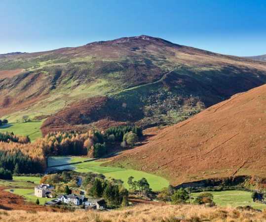
Suitably rested we crossed the river, stepping across the tops of boulders to the rough boggy ground opposite. Great caution must be exercised here for hidden rivulets are barely discernable amid long grass and tussocks. Following a fence uphill, avoiding boggy ground where possible, we headed NE towards the rocky summit. The Inchavore River with its swirls and curves of ancient oxbow lakes, faint outlines of former cottages and the gravelly finger of spoil heap spilling downhill from an old mine working on Kanturk’s slope, provide interesting views.

The brooding hulk of Tonelagee slipped steadily into view as we ascended, the clouds surrounding it turning an ominous battleship grey. Then its summit disappeared from view, lost in cloud. The wind increased and large drops of rain began to fall. We trudged onwards, the wind lashing the rain horizontally into our rear. Near the top the bracken and heather became denser and some light scrambling over granite boulders brought us eventually to the summit cairn. Even in rain, the majesty of these mountains is undimmed, the angry cloud rumbling and boiling over their summits.

Upon descending the wind suddenly dropped and we found ourselves in a rain shadow. All was absolutely still and silent apart from the croaky cries of ravens and the yelp of deer that we disturbed as we entered their realm, the wild and lonely Cloghoge Valley. Mesmerised by the beauty of this place, we watched as several herd of deer bounded effortlessly towards the brook, appearing to dance over the heather, while the cloud on the slopes of Luggala, Carrigvore and Gravale hung like smoke, the pungent smell of bracken and dank earth heightening our senses.

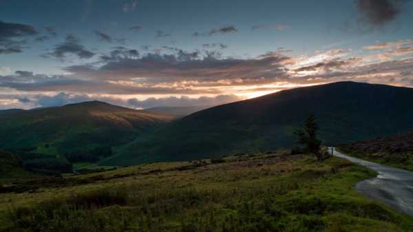
We then followed an old peat road down to the point where a bridge crosses the Cloghoge Brook and took the paved road towards the Pier Gates which gives fine views of the cliffs of Luggala and passes properties once connected to the surrounding estates. Near the top of the road the sun slipped below the cloud to bathe the Cloghoge Valley and Knocknacloghoge in a golden glow, igniting the heather on a nearby knoll, this epic scene completed by the silhouette of a gnarled may tree. The heavens erupted into a riot of colour as we stood spellbound, grateful for the fickleness of the weather that had made us feel truly alive that afternoon in the wilds of Wicklow. Linkback: mountainviews.ie/summit/386/comment/6042/
Read Less
Read More

            MountainViews.ie picture about Knocknacloghoge (<em>Cnoc na Clochóige</em>)
GWPR on Knocknacloghoge
by GWPR 12 Dec 2002
Start at the Pier Gates above Lough Tay and descend tarmac road to second wooden bridge on way to Lough Dan. Cloghoge Brook flows under this second bridge so cross bridge and go through metal gate on your right and follow brook upwards on your right. The brook falls through miniature ravines with many impressive waterfalls and deep pools. The colour here in the Autumn is magnificent! At it’s upper reaches the brook levels out and it’s a tough slog through the heather to reach Knocknaclogoge on the left. The views from the summit down to Lough Dan are fabulous. I have descended from the cliffs south of the summit with difficulty by keeping to the right. However the views down to the Inchavore River and its entrance to Lough Dan at the ‘Oasis’ make it worthwhile. Here,an island of sand with trees in autumn colour make a beautiful scene. If descending to the Oasis follow track along the eastern lake shore to reach a white house and from here there is a distinct track back to the bridge at Cloghoge Brook. Linkback: mountainviews.ie/summit/386/comment/243/
Read Less
Read More

Doug Lane on Knocknacloghoge
by Doug Lane 5 Aug 2003
Be wary of the track on the Eastern shore of Lough Dan. In David Herman's book, Hill Walkers Wicklow, he writes, "...a delightful path materialises along the shore of Lough Dan". The path is ANYTHING but delightful. It has become completely overgrown with gorse and ferns. Both of which hide eroded drop-offs and leave you scratched to bits. Do not attempt it if you are wearing shorts or a t-shirt, or waterproofs (unless you don't want them to remain waterproof).


It's really too bad because it's a sting in the tail of an otherwise enjoyable hike. Linkback: mountainviews.ie/summit/386/comment/600/

Read Less
Read More

gdempsey on Knocknacloghoge
by gdempsey 28 Jul 2005
I would echo Doug Lane's comments about this mountain - quote a decent hike / nice view from top but the descent to Lough Dan is treacherous / heavy undergrowth / almost broke my ankle in 2004 at the height of the summer when the heather and gorse were very high. Would also like to meet David Herman who wrote that book on hikes in Wicklow, and ask him what's pleasant about the last stage back towards the starting point - that path along the lakeshore is not in good condition and the gorse will rip the skin off you if you're wearing shorts. But hey, that's the great outdoors for you! Linkback: mountainviews.ie/summit/386/comment/1836/
Read Less
Read More

            MountainViews.ie picture about Knocknacloghoge (<em>Cnoc na Clochóige</em>)
skyehigh on Knocknacloghoge
by skyehigh 18 Jul 2005
While ascending Mullaghcleevaun (East Top), I was struck by the panorama to the east. Knocknacloghoge and Lough Dan feature, clouds showing the profile of the mountain to advantage. Linkback: mountainviews.ie/summit/386/comment/1823/
Read Less
Read More
EDIT Point of Interest
text
Videos


Recent Contributions
x
Conditions and Info
Use of MountainViews is governed by conditions and a privacy policy.
Read general information about the site.
Opinions in material here are not necessarily endorsed by MountainViews.
Hillwalking is a risk sport. Information in comments, walks, shared GPS tracks or about starting places may not be accurate for example as regards safety or access permission. You are responsible for your safety and your permission to walk.
See the credits and list definitions.

OSi logo
OSNI/LPS logo
Open Street Map
(Various variations used.)
British summit data courtesy:
Database of British & Irish Hills