Donation Request 2024

DONATE
Members and Supporters, the MountainViews Committee requests your help to meet the costs of the website and of other activities such as insured events or publications.
You do not have to be logged in to donate.
Features
Nearby features appear when you click the map.
Declutter tracks on map.
Place Search
Video
X
Pub: by
Wicklow Area , S: Croghan Kinsella Subarea
Feature count in area: 115, by county: Wicklow: 108, Kildare: 4, Wexford: 2, Carlow: 3, of which 1 is in both Wexford and Wicklow, of which 1 is in both Carlow and Wicklow, OSI/LPS Maps: 28B, 55, 56, 61, 62, AWW, EW-DM, EW-LG, EW-WE, EW-WS
Highest Place: Lugnaquilla 924.7m

Starting Places (205) in area Wicklow:
1916 Memorial Car Park, Aghavannagh Ow Bridge, Aghowle Wood, Altidore Wood Entrance, Annacurra National School, Annalecka Bridge, Asbawn Brook L8350, Aughrim National School, Ballard Road, Ballinabarny Gap, Ballinagappoge Bridge Layby, Ballinagappoge Mountain Hairpin, Ballinagore, Ballinahinch Wood, Ballinastoe MBT CP, Ballinastraw South, Ballineddan Upr Fork, Ballinfoyle Upr Cross, Ballycoog, Ballycreen Brook Bridge, Ballycumber, Ballycumber Bridge, Ballycumber Lane, Ballycumber Wicklow Way, Ballylerane, Ballylow Bridge, Ballylusk Quarry, Ballymanus Lane, Ballymoyle Shooting Lodge, Ballynultagh Gap, Ballynultagh Lane, Ballyreagh Wood, Ballyross Forest, Ballysmuttan Long Stone, Baravore, Barnbawn South, Barranisky North, Barranisky West, Bohilla Land Roundabout, Bohilla Lane Mid, Boranaraltry Bridge, Bray Harbour, Brewel West, Brittas Bay North CP, Buckroney Sand Dunes CP, Bus Terminus, Camera Hill Track Cross, Castletimon Wood North, Clara Vale, Clone House Road, Clonegal, Cloon Wood Cp, Coate Bridge, Coolballintaggart Ledge, Coolbawn House Lane, Cransillagh Brook , Crone Wood CP, Crossbridge, Crossoona Rath, Cummer Wood South, Curtlestown Wood CP, Deputy's Pass CP, Derralossary Church, Derry River Bridge, Devil's Glen CP, Devil's Glen Wood, Djouce Wood Calary, Djouce Wood Lake, Djouce Wood Long Hill, Donard, Donnelly's Lane Car Sales, Drumgoff Forest, Dunranhill North, Dunranhill SE, Dunranhill South, Dwyer McAllister Cottage CP, Enniskerry, Fentons Pub, Fitzsimons Park GAA, unuseableFlemings Footbridge Glen Rd, Gap Pub, Gap Road, Glen Beach CP, Glen of the Downs CP, Glenbride Lane, Glenbride Lodge, Glencree Reconciliation, Glendalough, Glenealy GAA, Glenmacnass Tonelagee CP, Glenmalure Hostel, Glenmalure Lodge, Glenmalure Waterfall, Glenview Hotel, Gowle House, Great Sugar Loaf CP, Grove Bar, Heffernans Well Wood, Hill View, Hollywood Glen, JB Malone CP, Johnnie Fox Pub, Keadeen NE trail, Keadeen Trailhead, Kevins Way Footbridge, Kilbride Army Camp Entrance, Kilcandra South, Kilcommon View, Killalongford Wood, Kilmacrea Cross Roads, Kilranelagh House Gate, Kilruddery Car Park, Kilruddery Cottages, Kings River, Kippure Bridge, Kippure Estate, Kippure Transmitter Gate, Knickeen Cross, Knocknaboley Lane Leeraghs Bog, Knocknaboley Lane Stone Cottage, Knockrath Little, Knockree west, Kyle Loop North, Lackan Wood S, Lake Dr Fraughan Brook, Lake Drive, Lake Park Cross, Lake View Pub, Laragh Free Car Park, Laragh NSch, Lead Mines CP, Liffey Bridge, Liffey Head Bridge, Lough Bray Lower, Lough Bray Upper, Lough Tay North Viewing Point, Lough Tay Wicklow Way CP, Luglass Lane L97561, Lugnagun Track, Macreddin Village, Mangans Lane, Military Road Carrigshouk Hill, Military Road Inchavore River Nth, Military Road Inchavore River Sth, Military Road NW Lough Tay, Military Road Ballyboy Bridge, Military Road Cloghoge Brook, Military Road Croaghanmoira, Military Road Fananierin, Military Road LaraghWicklow Way, Military Road Slieve Maan, Monspolien Bridge, Moortown House, Mountain Rescue HQ, Muskeagh Little Wood, Nahanagan Lough NE, Novara Avenue, Bray, Oiltiagh Brook Knickeen, Old Bridge Cross, Old Bridge Scouts , Old Wicklow Way entrance, Paddock Hill SE, Pier Gates CP, Powerscourt Waterfall CP, Putland Road, Quintagh East, Raheen Park CP, Raheenleagh East, Railway Walk CP, Rathdrum Railway Station, Rednagh Wood, Rocky Valley, Roundwood, Sally Gap, Sally Gap N, Seefin Trailhead, Seskin SE, Shankill Tributary Bridge, Shay Elliott, Sheepshanks Bridge, Shillelagh, Slievecorragh Track, Slievefoore South, Sraghoe Brook, St John's Church, St Kevins Chair, St Kevins Church, St Kevins Way R756, Stone Circle Bridge, Stookeen South, Stranahely Wood, Stranakelly Cross Roads, Tallyho, Templeboden, Tithewer, Tomcoyle L, Tomriland Wood, Toor Brook, Trooperstown Hill Access, Turlough Hill CP, Upper Lake CP, Vallymount GAA CP, Vartry Reservoir Upper, Zellers Pub

Summits & other features in area Wicklow:
Cen: Glendalough North: Brockagh Mountain 556.9m, Brockagh Mountain NW Top 549.5m, Brockagh Mountain SE Top 471.7m, Camaderry East Top 677.3m, Camaderry Mountain 698.6m, Conavalla 734m, Tomaneena 682.4m
Cen: Glendalough South: Carriglineen Mountain 456.6m, Cullentragh Mountain 510m, Derrybawn Mountain 476.1m, Kirikee Mountain 474.5m, Lugduff 653.2m, Lugduff SE Top 638m, Mullacor 660.7m, Trooperstown Hill 430m
N Cen: Tonelagee: Carrignagunneen 561m, Fair Mountain 571.2m, Stoney Top 713.7m, Tonelagee 815.8m, Tonelagee E Top 668m, Tonelagee South-East Top 545.8m
NE: Bray & Kilmacanogue: Bray Head Hill 238.9m, Carrigoona Commons East 242m, Downs Hill 372.9m, Great Sugar Loaf 501.2m, Little Sugar Loaf 342.4m
NE: Djouce: Djouce 725.5m, Knockree 342.1m, Maulin 570m, Tonduff 642m, Tonduff East Top 593m, War Hill 684.8m, White Hill 631.1m
NE: Fancy: Ballinafunshoge 480m, Kanturk 527.4m, Knocknacloghoge 532.4m, Luggala 593.3m, Robber's Pass Hill 508.9m, Scarr 640m, Scarr North-West Top 559.8m, Sleamaine 430m
NE: Vartry: Ballinacorbeg 336m, Ballycurry 301m, Dunranhill 342m, Mount Kennedy 365.9m
NW: Blessington: Carrigleitrim 408m, Lugnagun 446.2m, Slieveroe 332m, Sorrel Hill 599.5m
NW: Mullaghcleevaun: Black Hill 602.2m, Carrigshouk 572.5m, Carrigvore 682.4m, Duff Hill 720.8m, Gravale 719m, Moanbane 703m, Mullaghcleevaun 846.7m, Mullaghcleevaun East Top 796m, Silsean 698m
S: Aughrim Hills: Cushbawn 400m, Killeagh 249m, Moneyteige North 427m, Preban Hill 389m
S: Croaghanmoira: Ballinacor Mountain 529.3m, Ballycurragh Hill 536m, Ballyteige 447m, Carrickashane Mountain 508m, Croaghanmoira 662.3m, Croaghanmoira North Top 579.5m, Fananierin 426m, Slieve Maan 547.8m, Slieve Maan North Top 546.1m
S: Croghan Kinsella: Annagh Hill 454m, Croghan Kinsella 606m, Croghan Kinsella East Top 562.1m, Slievefoore 414m
S: Shillelagh Hills: Lakeen 357m, Monaughrim 206m, Seskin 344m, Stookeen 420m
S: Tinahely Hills: Ballycumber Hill 429.7m, Eagle Hill 296m, Muskeagh Hill 398.2m
SE: Wicklow South East: Ballinastraw 284m, Ballyguile Hill 188m, Barranisky 280m, Carrick Mountain 381m, Collon Hill 238m, Kilnamanagh Hill 217m, Westaston Hill 270m
W: Baltinglass: Ballyhook Hill 288m, Baltinglass Hill 382m, Carrig Mountain 571m, Carrigeen Hill 298m, Cloghnagaune 385m, Corballis Hill 258m, Keadeen Mountain 653m, Spinans Hill 409m, Spinans Hill SE Top 400m, Tinoran Hill 312m
W: Cen Lugnaquilla: Ballineddan Mountain 652.3m, Benleagh 689m, Camenabologue 758m, Camenabologue SE Top 663m, Cloghernagh 800m, Corrigasleggaun 794.6m, Lugnaquilla 924.7m, Slievemaan 759.7m
W: Donard: Brewel Hill 222m, Church Mountain 544m, Corriebracks 531m, Lobawn 636m, Slievecorragh 418m, Sugarloaf 552m, Table Mountain 701.7m, Table Mountain West Top 563m

Note: this list of places may include island features such as summits, but not islands as such.
Rating graphic.
Croghan Kinsella, 606m Mountain Cruachán A name in Irish,
Place Rating ..
(Ir. Cruachán [GE], 'little stack'), The Pinnacle, Croghan Kinshelagh, Wexford/ Wicklow County in Leinster province, in Arderin, Vandeleur-Lynam Lists, Croghan Kinsella is the 274th highest place in Ireland.
Grid Reference T13096 72884, OS 1:50k mapsheet 62
Place visited by: 266 members, recently by: rhw, michaelseaver, davidrenshaw, Carolineswalsh, ToughSoles, Sarahjb, mdehantschutter, Carolyn105, Krzysztof_K, Pepe, trampisob, benjimann9, Timmy.Mullen, NualaB, MickM45
I visited this place: NO (You need to be a logged-in member for this.)
Longitude: -6.324118, Latitude: 52.795465, Easting: 313096, Northing: 172884, Prominence: 541m,  Isolation: 0.8km, Has trig pillar
ITM: 713020 672923
Bedrock type: Basalt and gabbro, (Dolerite)
Notes on name: The Uí Chinnsealaigh were the dominant Gaelic family in this area and the mountain gets the fuller version of its name from them. This helps to distinguish it from Croaghanmoira, which is a little further north.
  Short or GPS IDs, 6 char: CrghKn, 10 char: CrghnKnsl

Linkback: https://mountainviews.ie/summit/261/
Gallery for Croghan Kinsella (Cruachán) and surrounds
Summary for Croghan Kinsella (Cruachán): A very accessible Top.
Summary created by Harry Goodman 2015-03-30 23:18:15
            MountainViews.ie picture about Croghan Kinsella (<em>Cruachán</em>)
Picture: View NE to Croghan Kinsella from Annagh Hill.
Park at the entrance to Raheenleagh Forest SlFoore S (T15294 71417) where there is room for several cars. Follow the main forest track up WNW keeping right at A (T14917 72046), just after a dip in the upward path and then higher up at B (T14879 73038) keep left. (Please note that the track on the ground is much more direct and easy to follow than would appear from those shown on OSi Sheet 62 (3rd Edition) and that no tracks at all are shown in the later 4th Edition.) Continue up to its end at C (T13602 73092) ignoring any branches off on the right. The summit lies to the SE about 400 metres further along a less defined but easy to follow path up over peaty ground and some rock. It is marked by a Trig Pillar prominently set on a small rocky up crop. Vews N can trace the full W to E line of the Wicklow Mountains from Keadeen Mt. across to the Great Sugarloaf and SW over Annagh Hill to the Blackstairs. Add to this views E over Slievefoore for a sweep along the E coast to complete a perfect panorama. The provision of the good track, almost to the top, make Croghan Kinsella a most accessible mountain for all.
Linkback: mountainviews.ie/summit/261/comment/5021/
Member Comments for Croghan Kinsella (Cruachán)
Comment create / edit display placeholder

milo on Croghan Kinsella
by milo 30 Aug 2003
Revisited Croghan after a interval of nearly 30 years. The additional fencing and clearfelled forestry made for a less pleasant walk than I had anticipated. However the panorama to the south did not disappoint. Easiest ascent from the forest entrance is to leave the track at the bend D (T145 735) and follow the eastern forest edge to 540 metres. A pleasant return track contours below the southern edge of currently standing timber to re-enter forest at E (T149 730). Parking is limited to about 2 cars Linkback: mountainviews.ie/summit/261/comment/625/
Read Less
Read More

            MountainViews.ie picture about Croghan Kinsella (<em>Cruachán</em>)
simon3 on Croghan Kinsella
by simon3 1 Apr 2003
This is an isolated peak giving a quite different vista compared to anything else in the Wicklow Mountains. In fact it is only just in Wicklow, since its summit is part of the Wicklow/ Wexford boundary. One way of accessing it is from the Raheenleagh Wood forest entrance at F (T152 714). The main forest tracks are accurately enough represented on the 1:50k map that you can find your way using it.
The summit itself is easily reached and recognisable from a trig pillar and group of rocks. The older Irish Walk Guides: East included a walk starting from North West of the summit at G (T104 744). This route went over Croghan and on to Moneyteige North (427m) and rejoined the roads at around H (T148 791). (I don't know if the exact start and finish are still useable, though I did meet a group on Croghan's summit who seemed to be doing something similar)
The view here includes Annagh Hill (454m) partly wooded to the left and in the distance on the skyline, the Blackstairs. Linkback: mountainviews.ie/summit/261/comment/416/
Read Less
Read More

            MountainViews.ie picture about Croghan Kinsella (<em>Cruachán</em>)
Picture: Kinsella Child - a natural curiousity.
A Miniature Coffin Stone
by simon3 5 Apr 2010
On a trip up the south west spur led by the knowledgeable local Tom (of the labradors), we came to this uncelebrated but remarkable natural whitish object. Hereby it is known as the Kinsella Child. Linkback: mountainviews.ie/summit/261/comment/4579/
Read Less
Read More

            MountainViews.ie picture about Croghan Kinsella (<em>Cruachán</em>)
Picture: Looking North West to Keadeen (centre) and Lug (right)
Fine views and a gilded history
by Bunsen7 23 Sep 2018
Decided it couldn't do any harm to get on the M11 down past Arklow and make the journey to Croghan Kinsella.

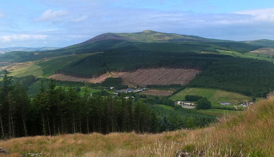
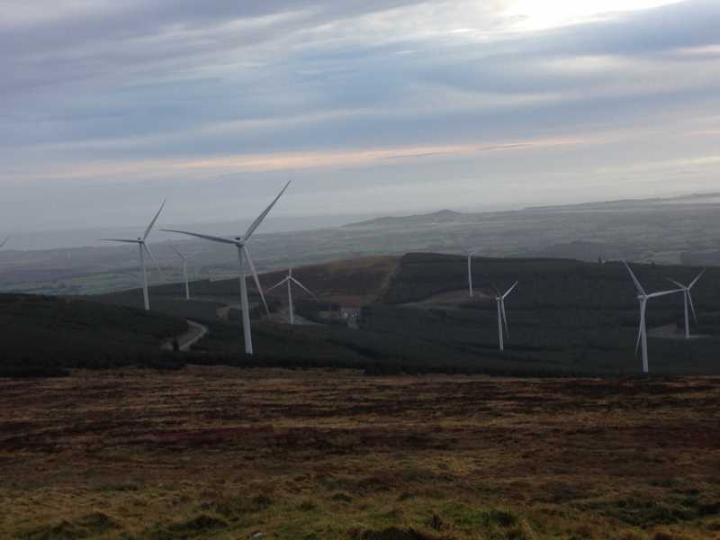
Coillte and the ESB have created a 35 MW wind-farm on the eastern flanks of the mountain between the main mountain and Slievefore to the east.

Probably to seek to allay concerns of people in the vicinity, the bodies have sought to market the recreational use of the forest tracks that lead to the summit and the windfarm from the entrance at White Heaps.

I suppose in some respects it's not totally far removed from the late 18th and early 19th century when government appointed geologists were directing gold mining works on the north of the mountain - there's an economy to drive one way or the other. Back then, men were tunnelling hundreds of metres into the mountainside, now there are structures rising almost 100 metres above the land.

A contemporaneous account by one of the Directors of the mine, Thomas Weaver (of whom there are apparently trenches named on the latest mapping of the northside of CK), offers a vivid insight into the times that were (see also comments on the Moneyteige summit page):

"The discovery of native gold in the Ballinvalley stream at Croghan Kinshela was accidental, and at first kept secret, but being divulged, almost the whole population of the immediate neighbourhood flocked in to gather so rich an harvest, actually neglecting at the time the produce of their own fields. This happened about the autumn of the year 1796, when several hundreds of people might be seen daily assembled digging and searching for gold in the banks and the bed of the stream. [...] The populace remained in undisturbed possession of the place for nearly six weeks, when Government determined to commence active operations. An Act of Parliament was then passed for the management of the undertaking [...] and up to the unhappy period of the rebellion in May 1798, when the works were destroyed, Government had been fully reimbursed its advances [...]. In the year 1801, the operations were resumed, when the directors proposed to Government not to confine its views to the mere collection of the alluvial gold, but to extend the researches, directing them more particularly toward the discovery of the auriferous veins."

Who knows what it will be like 200 years from now? An Ozymandias-esque array of decaying wind turbines presumably! Linkback: mountainviews.ie/summit/261/comment/20071/
Read Less
Read More

            MountainViews.ie picture about Croghan Kinsella (<em>Cruachán</em>)
Windfarms completed. Walking trails nearly ready but the trails are industrial
by mickhanney 10 Dec 2016
Jogged up Croghan Kinsella from entrance at Ballinvalley near Ballycoog where there is space for a couple of cars. The trail upwards is wide and rather industrial in nature. The trail switches back a few times before you ascend up to where the new windfarm is complete. There are walking trails about to open here but the signposts are still incomplete The work on the windfarm has introduced wide roadways on the mountain which are decidedly ugly. This allied to the reduced tree cover near the windfarms spoils the outlook on the mountain. Its a pity that once the windfarms are installed they don't restore the trails to the natural look they were before. However, when you ascend to the top of Croghan Kinsella the views are worthwhile, in all directions. Jogged back downhill to Ballyvalley Linkback: mountainviews.ie/summit/261/comment/18725/
Read Less
Read More
EDIT Point of Interest
text
Videos


Recent Contributions
x
Conditions and Info
Use of MountainViews is governed by conditions and a privacy policy.
Read general information about the site.
Opinions in material here are not necessarily endorsed by MountainViews.
Hillwalking is a risk sport. Information in comments, walks, shared GPS tracks or about starting places may not be accurate for example as regards safety or access permission. You are responsible for your safety and your permission to walk.
See the credits and list definitions.

OSi logo
OSNI/LPS logo
Open Street Map
(Various variations used.)
British summit data courtesy:
Database of British & Irish Hills