Members and Supporters, the MountainViews Committee requests your help to meet the costs of the website and of other activities such as insured events or publications.
Feature count in area: 115, by county: Wicklow: 108, Kildare: 4, Wexford: 2, Carlow: 3, of which 1 is in both Wexford and Wicklow, of which 1 is in both Carlow and Wicklow,
OSI/LPS Maps: 28B, 55, 56, 61, 62, AWW, EW-DM, EW-LG, EW-WE, EW-WS
Highest Place: Lugnaquilla 924.7m
Starting Places (205) in area Wicklow: 1916 Memorial Car Park, Aghavannagh Ow Bridge, Aghowle Wood, Altidore Wood Entrance, Annacurra National School, Annalecka Bridge, Asbawn Brook L8350, Aughrim National School, Ballard Road, Ballinabarny Gap, Ballinagappoge Bridge Layby, Ballinagappoge Mountain Hairpin, Ballinagore, Ballinahinch Wood, Ballinastoe MBT CP, Ballinastraw South, Ballineddan Upr Fork, Ballinfoyle Upr Cross, Ballycoog, Ballycreen Brook Bridge, Ballycumber, Ballycumber Bridge, Ballycumber Lane, Ballycumber Wicklow Way, Ballylerane, Ballylow Bridge, Ballylusk Quarry, Ballymanus Lane, Ballymoyle Shooting Lodge, Ballynultagh Gap, Ballynultagh Lane, Ballyreagh Wood, Ballyross Forest, Ballysmuttan Long Stone, Baravore, Barnbawn South, Barranisky North, Barranisky West, Bohilla Land Roundabout, Bohilla Lane Mid, Boranaraltry Bridge, Bray Harbour, Brewel West, Brittas Bay North CP, Buckroney Sand Dunes CP, Bus Terminus, Camera Hill Track Cross, Castletimon Wood North, Clara Vale, Clone House Road, Clonegal, Cloon Wood Cp, Coate Bridge, Coolballintaggart Ledge, Coolbawn House Lane, Cransillagh Brook , Crone Wood CP, Crossbridge, Crossoona Rath, Cummer Wood South, Curtlestown Wood CP, Deputy's Pass CP, Derralossary Church, Derry River Bridge, Devil's Glen CP, Devil's Glen Wood, Djouce Wood Calary, Djouce Wood Lake, Djouce Wood Long Hill, Donard, Donnelly's Lane Car Sales, Drumgoff Forest, Dunranhill North, Dunranhill SE, Dunranhill South, Dwyer McAllister Cottage CP, Enniskerry, Fentons Pub, Fitzsimons Park GAA, unuseableFlemings Footbridge Glen Rd, Gap Pub, Gap Road, Glen Beach CP, Glen of the Downs CP, Glenbride Lane, Glenbride Lodge, Glencree Reconciliation, Glendalough, Glenealy GAA, Glenmacnass Tonelagee CP, Glenmalure Hostel, Glenmalure Lodge, Glenmalure Waterfall, Glenview Hotel, Gowle House, Great Sugar Loaf CP, Grove Bar, Heffernans Well Wood, Hill View, Hollywood Glen, JB Malone CP, Johnnie Fox Pub, Keadeen NE trail, Keadeen Trailhead, Kevins Way Footbridge, Kilbride Army Camp Entrance, Kilcandra South, Kilcommon View, Killalongford Wood, Kilmacrea Cross Roads, Kilranelagh House Gate, Kilruddery Car Park, Kilruddery Cottages, Kings River, Kippure Bridge, Kippure Estate, Kippure Transmitter Gate, Knickeen Cross, Knocknaboley Lane Leeraghs Bog, Knocknaboley Lane Stone Cottage, Knockrath Little, Knockree west, Kyle Loop North, Lackan Wood S, Lake Dr Fraughan Brook, Lake Drive, Lake Park Cross, Lake View Pub, Laragh Free Car Park, Laragh NSch, Lead Mines CP, Liffey Bridge, Liffey Head Bridge, Lough Bray Lower, Lough Bray Upper, Lough Tay North Viewing Point, Lough Tay Wicklow Way CP, Luglass Lane L97561, Lugnagun Track, Macreddin Village, Mangans Lane, Military Road Carrigshouk Hill, Military Road Inchavore River Nth, Military Road Inchavore River Sth, Military Road NW Lough Tay, Military Road Ballyboy Bridge, Military Road Cloghoge Brook, Military Road Croaghanmoira, Military Road Fananierin, Military Road LaraghWicklow Way, Military Road Slieve Maan, Monspolien Bridge, Moortown House, Mountain Rescue HQ, Muskeagh Little Wood, Nahanagan Lough NE, Novara Avenue, Bray, Oiltiagh Brook Knickeen, Old Bridge Cross, Old Bridge Scouts , Old Wicklow Way entrance, Paddock Hill SE, Pier Gates CP, Powerscourt Waterfall CP, Putland Road, Quintagh East, Raheen Park CP, Raheenleagh East, Railway Walk CP, Rathdrum Railway Station, Rednagh Wood, Rocky Valley, Roundwood, Sally Gap, Sally Gap N, Seefin Trailhead, Seskin SE, Shankill Tributary Bridge, Shay Elliott, Sheepshanks Bridge, Shillelagh, Slievecorragh Track, Slievefoore South, Sraghoe Brook, St John's Church, St Kevins Chair, St Kevins Church, St Kevins Way R756, Stone Circle Bridge, Stookeen South, Stranahely Wood, Stranakelly Cross Roads, Tallyho, Templeboden, Tithewer, Tomcoyle L, Tomriland Wood, Toor Brook, Trooperstown Hill Access, Turlough Hill CP, Upper Lake CP, Vallymount GAA CP, Vartry Reservoir Upper, Zellers Pub
Summits & other features in area Wicklow: Cen: Glendalough North: Brockagh Mountain 556.9m, Brockagh Mountain NW Top 549.5m, Brockagh Mountain SE Top 471.7m, Camaderry East Top 677.3m, Camaderry Mountain 698.6m, Conavalla 734m, Tomaneena 682.4m Cen: Glendalough South: Carriglineen Mountain 456.6m, Cullentragh Mountain 510m, Derrybawn Mountain 476.1m, Kirikee Mountain 474.5m, Lugduff 653.2m, Lugduff SE Top 638m, Mullacor 660.7m, Trooperstown Hill 430m N Cen: Tonelagee: Carrignagunneen 561m, Fair Mountain 571.2m, Stoney Top 713.7m, Tonelagee 815.8m, Tonelagee E Top 668m, Tonelagee South-East Top 545.8m NE: Bray & Kilmacanogue: Bray Head Hill 238.9m, Carrigoona Commons East 242m, Downs Hill 372.9m, Great Sugar Loaf 501.2m, Little Sugar Loaf 342.4m NE: Djouce: Djouce 725.5m, Knockree 342.1m, Maulin 570m, Tonduff 642m, Tonduff East Top 593m, War Hill 684.8m, White Hill 631.1m NE: Fancy: Ballinafunshoge 480m, Kanturk 527.4m, Knocknacloghoge 532.4m, Luggala 593.3m, Robber's Pass Hill 508.9m, Scarr 640m, Scarr North-West Top 559.8m, Sleamaine 430m NE: Vartry: Ballinacorbeg 336m, Ballycurry 301m, Dunranhill 342m, Mount Kennedy 365.9m NW: Blessington: Carrigleitrim 408m, Lugnagun 446.2m, Slieveroe 332m, Sorrel Hill 599.5m NW: Mullaghcleevaun: Black Hill 602.2m, Carrigshouk 572.5m, Carrigvore 682.4m, Duff Hill 720.8m, Gravale 719m, Moanbane 703m, Mullaghcleevaun 846.7m, Mullaghcleevaun East Top 796m, Silsean 698m S: Aughrim Hills: Cushbawn 400m, Killeagh 249m, Moneyteige North 427m, Preban Hill 389m S: Croaghanmoira: Ballinacor Mountain 529.3m, Ballycurragh Hill 536m, Ballyteige 447m, Carrickashane Mountain 508m, Croaghanmoira 662.3m, Croaghanmoira North Top 579.5m, Fananierin 426m, Slieve Maan 547.8m, Slieve Maan North Top 546.1m S: Croghan Kinsella: Annagh Hill 454m, Croghan Kinsella 606m, Croghan Kinsella East Top 562.1m, Slievefoore 414m S: Shillelagh Hills: Lakeen 357m, Monaughrim 206m, Seskin 344m, Stookeen 420m S: Tinahely Hills: Ballycumber Hill 429.7m, Eagle Hill 296m, Muskeagh Hill 398.2m SE: Wicklow South East: Ballinastraw 284m, Ballyguile Hill 188m, Barranisky 280m, Carrick Mountain 381m, Collon Hill 238m, Kilnamanagh Hill 217m, Westaston Hill 270m W: Baltinglass: Ballyhook Hill 288m, Baltinglass Hill 382m, Carrig Mountain 571m, Carrigeen Hill 298m, Cloghnagaune 385m, Corballis Hill 258m, Keadeen Mountain 653m, Spinans Hill 409m, Spinans Hill SE Top 400m, Tinoran Hill 312m W: Cen Lugnaquilla: Ballineddan Mountain 652.3m, Benleagh 689m, Camenabologue 758m, Camenabologue SE Top 663m, Cloghernagh 800m, Corrigasleggaun 794.6m, Lugnaquilla 924.7m, Slievemaan 759.7m W: Donard: Brewel Hill 222m, Church Mountain 544m, Corriebracks 531m, Lobawn 636m, Slievecorragh 418m, Sugarloaf 552m, Table Mountain 701.7m, Table Mountain West Top 563m
Note: this list of places may include island features such as summits, but not
islands as such.
Table Mountain, 701.7mMountain Sliabh an Tábla A name in Irish,
Place Rating ..
This is a name coined in English., Black Banks, Urch, Wicklow County in Leinster province, in Arderin Beg, Vandeleur-Lynam Lists, Table Mountain is the 112th highest place in Ireland.
Grid Reference T01958 97292,
OS 1:50k mapsheet 56 Place visited by: 569members, recently by: Hjonna, rhw, maoris, davidrenshaw, Prem, Carolineswalsh, konrad, NualaB, ToughSoles, muddypaws, SeanPurcell, SmirkyQuill, mdehantschutter, Magic, Kaszmirek78
I visited this place: NO (You need to be a logged-in member for this.)
Longitude: -6.481516, Latitude: 53.016928, Easting: 301958, Northing: 197292,
Prominence: 15.8m, Isolation: 1.4km ITM: 701885 697326 Bedrock type: Aphyric granodiorite, (Percys Table Granodiorite) Notes on name: This peak is flat-topped, but otherwise bears no comparison with its namesake above Cape Town. Table Mountain is also a townland in the parish of Donaghmore. The historical attestations of this name are in English. The Irish name Sliabh an Tábla given at logainm.ie is a translation into Irish.
Short or GPS IDs, 6 char: TblMnt, 10 char: TblMntn Linkback: https://mountainviews.ie/summit/109/
Gallery for Table Mountain (Sliabh an Tábla) and surrounds
Summary
for Table Mountain (Sliabh an Tábla):
Easy access to a 700 metre summit
Summary created by wicklore
2010-10-17 14:18:47
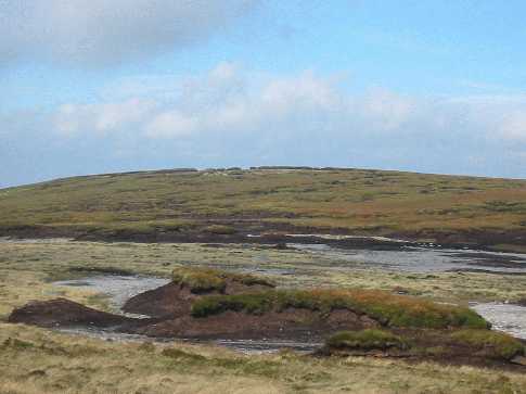
Picture: Glorious Table
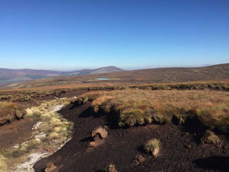
The Table Track, which runs from the end of the Glenmalure Valley, rises to 694 metres altitude, and passes within a few hundred metres of the summit of Table Mountain. This gives easy access to this high Wicklow hill. The Table Track was used over the years as an access route between Glen of Imaal and Glenmalure, and facilitated many a rebel moving between the Glens to avoid capture.
Starting at the carpark at B'vore (T06617 94163) , walk across the ford, getting your feet wet. (as of October 2010 the nearby footbridge is destroyed following heavy rain, floods and landslides in the Glenmalure Valley. If the river is too high the ford will be impassable to either foot or vehicle traffic, but there is no real way of knowing until you get there)
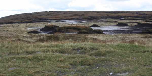
Once across the ford, follow the Coillte track for several kilometers higher into the valley until you reach a junction at A (T03458 96141) which heads up over open bog. This bog track, interspersed with short pieces of wooden boardwalk over the worst boggy sections, leads to the col between Table Mountain and Camenabologue at B (T02085 96698) . Table Mountain is a 10 minute walk north over heather and bog. It is a very unexciting summit, with very little climb from the col. Total length from carpark to summit is 6.5 kms.
Views from Table Mountain are extensive, including the three highest Wicklow Mountains - Lugnaquilia, Tonelagee and Mullaghcleevaun - as well as the elusive Three Lakes, Turlough Hill and dozens of other Wicklow summits.
Climbed Table mountain and Camenabologue today,parking at Barravore,crossing the Avonbeg at the ford and heading NW along the table track keeping the river on my right until crossing it at a small crossing at C (T034 962).The track crosses forest road at times but can be followed all the way to the col between Table mountain and Camenabologue where there is an Army you are here sign.Table is an uninspiring boggy piece of high ground north of the sign but offers spectacular views over the Blessington lakes as well as Mullacleevaun ,the three lakes(although I could only make out two) and Tongalee.Heading back to the sign I climbed the short distance to Camenabolgue before retracing my route to the car.Distance 14.5km,time taken 3 hrs 55 mins,Ascent 642 m,Descent 621 Linkback: mountainviews.ie/summit/109/comment/18338/
Read Less
Read More
padodes on Table Mountain
by padodes
22 Mar 2010
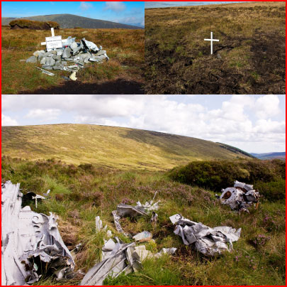
Table may be a mountain you cross on your way to somewhere else (cairn on the flat top at D (T0191 9734)), but it has its own little secrets if you care to look for them. One happens to be the wreck of a light aircraft on its lower eastern slope at E (T0273 9729), almost in the hollow between Table and Conavalla. Together with the spot where a plane came down on Corrigasleggaun in 1992 with the loss of two lives, and another spot where a similar accident took place on Corriebracks in 2008 with the loss of four, this one forms part of a kind of Bermuda Triangle (at least in my fancy) on the SW side of the Wicklow massif. Unlike the two other crashes that are well documented, little seems to be known about the one on Table. I have never been able to find a record of it. (The list given by the Air Accident Investigation Unit of the Department of Transport only goes back to 1996.) When did it happen? What were the circumstances? Was there a loss of life? Considering that not even the engine was winched away for investigation, as would occur in more recent times, the accident must go back quite a number of years; and judging by the tortured strips of fuselage that remain, the landing cannot have been a gentle one. The terrain is rough and remote in this area and any survivor would have needed at the very least, in my reckoning, an hour of vigorous walking to reach the nearest human habitation in Glenmalure.
Photo: upper left, the crash site on Corrigasleggaun; upper right, the recent one on Corriebracks, marked today by a simple wooden cross; and below, the scattered remains on Table, looking towards Conavalla. Linkback: mountainviews.ie/summit/109/comment/4525/
Read Less
Read More
Further information on the air accident
by malonesean
12 Apr 2012
The aircraft was flown by a lt. Patrick Leo O'Connor. It crashed in bad weather on March 7th 1957. His family visited the site in September 2010 to place a plaque in his honour. Details of the visit were published in the Roscommon Herald, October 5th 2010. He was buried on his 21st birthday. Linkback: mountainviews.ie/summit/109/comment/6767/
Read Less
Read More
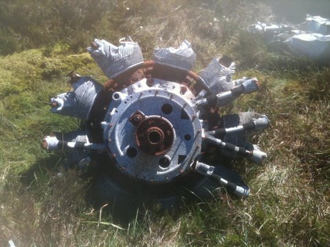
Picture: The Provost Engine
The Provost wreckage
by Townie
21 Jun 2010
I climbed Table Mountain with the a view to examining the aircraft wreck on the NE slope of the mountain. I know a little bit about aeroplanes so here goes. The Engine is 9 cylinder Alvis Leonidas rotary engine. This type of engine powered the Irish Air Corp Provost aeroplanes which were in service from the mid fifties. This is the remaining wreckage of a Provost which crashed there in March 1957. The pilot who was 21 died shortly after the crash. The accident is featured in the Irish Times of 8th March 1957. Please spare a thought for the unfortunate pilot should you visit the mountain. Linkback: mountainviews.ie/summit/109/comment/5892/
Read Less
Read More
csd on Table Mountain
by csd
14 Sep 2003
Being rather flat, it's quite hard to discern the summit of Table Mountain. Nearby Three Lakes (though I only counted two!) makes a nice spot for lunch. The dreaded quad bikers are sometimes active in this area - watch your step! Picture shows the summit taken from the track up from Baravore. Linkback: mountainviews.ie/summit/109/comment/643/
Use of MountainViews is governed by conditions and a privacy policy.
Read general information about the site. Opinions in material here are not necessarily endorsed by MountainViews.
Hillwalking is a risk sport. Information in comments, walks, shared GPS tracks or about starting places may
not be accurate for example as regards safety or access permission. You are responsible for your safety and your permission to walk.
See the credits and list definitions.


 Our Facebook page.