Cookies.
This website uses cookies, which are small text files that the website puts on your device to facilitate operation. Cookies help us provide a better service to you. They are used to track general user traffic information and to help the website function properly.
Features
Nearby features appear when you click the map.
Declutter tracks on map.
Place Search
Video
X
Pub: by
Wicklow Area , S: Aughrim Hills Subarea
Feature count in area: 115, by county: Wicklow: 108, Kildare: 4, Wexford: 2, Carlow: 3, of which 1 is in both Wexford and Wicklow, of which 1 is in both Carlow and Wicklow, OSI/LPS Maps: 28B, 55, 56, 61, 62, AWW, EW-DM, EW-LG, EW-WE, EW-WS
Highest Place: Lugnaquilla 924.7m

Starting Places (205) in area Wicklow:
1916 Memorial Car Park, Aghavannagh Ow Bridge, Aghowle Wood, Altidore Wood Entrance, Annacurra National School, Annalecka Bridge, Asbawn Brook L8350, Aughrim National School, Ballard Road, Ballinabarny Gap, Ballinagappoge Bridge Layby, Ballinagappoge Mountain Hairpin, Ballinagore, Ballinahinch Wood, Ballinastoe MBT CP, Ballinastraw South, Ballineddan Upr Fork, Ballinfoyle Upr Cross, Ballycoog, Ballycreen Brook Bridge, Ballycumber, Ballycumber Bridge, Ballycumber Lane, Ballycumber Wicklow Way, Ballylerane, Ballylow Bridge, Ballylusk Quarry, Ballymanus Lane, Ballymoyle Shooting Lodge, Ballynultagh Gap, Ballynultagh Lane, Ballyreagh Wood, Ballyross Forest, Ballysmuttan Long Stone, Baravore, Barnbawn South, Barranisky North, Barranisky West, Bohilla Land Roundabout, Bohilla Lane Mid, Boranaraltry Bridge, Bray Harbour, Brewel West, Brittas Bay North CP, Buckroney Sand Dunes CP, Bus Terminus, Camera Hill Track Cross, Castletimon Wood North, Clara Vale, Clone House Road, Clonegal, Cloon Wood Cp, Coate Bridge, Coolballintaggart Ledge, Coolbawn House Lane, Cransillagh Brook , Crone Wood CP, Crossbridge, Crossoona Rath, Cummer Wood South, Curtlestown Wood CP, Deputy's Pass CP, Derralossary Church, Derry River Bridge, Devil's Glen CP, Devil's Glen Wood, Djouce Wood Calary, Djouce Wood Lake, Djouce Wood Long Hill, Donard, Donnelly's Lane Car Sales, Drumgoff Forest, Dunranhill North, Dunranhill SE, Dunranhill South, Dwyer McAllister Cottage CP, Enniskerry, Fentons Pub, Fitzsimons Park GAA, unuseableFlemings Footbridge Glen Rd, Gap Pub, Gap Road, Glen Beach CP, Glen of the Downs CP, Glenbride Lane, Glenbride Lodge, Glencree Reconciliation, Glendalough, Glenealy GAA, Glenmacnass Tonelagee CP, Glenmalure Hostel, Glenmalure Lodge, Glenmalure Waterfall, Glenview Hotel, Gowle House, Great Sugar Loaf CP, Grove Bar, Heffernans Well Wood, Hill View, Hollywood Glen, JB Malone CP, Johnnie Fox Pub, Keadeen NE trail, Keadeen Trailhead, Kevins Way Footbridge, Kilbride Army Camp Entrance, Kilcandra South, Kilcommon View, Killalongford Wood, Kilmacrea Cross Roads, Kilranelagh House Gate, Kilruddery Car Park, Kilruddery Cottages, Kings River, Kippure Bridge, Kippure Estate, Kippure Transmitter Gate, Knickeen Cross, Knocknaboley Lane Leeraghs Bog, Knocknaboley Lane Stone Cottage, Knockrath Little, Knockree west, Kyle Loop North, Lackan Wood S, Lake Dr Fraughan Brook, Lake Drive, Lake Park Cross, Lake View Pub, Laragh Free Car Park, Laragh NSch, Lead Mines CP, Liffey Bridge, Liffey Head Bridge, Lough Bray Lower, Lough Bray Upper, Lough Tay North Viewing Point, Lough Tay Wicklow Way CP, Luglass Lane L97561, Lugnagun Track, Macreddin Village, Mangans Lane, Military Road Carrigshouk Hill, Military Road Inchavore River Nth, Military Road Inchavore River Sth, Military Road NW Lough Tay, Military Road Ballyboy Bridge, Military Road Cloghoge Brook, Military Road Croaghanmoira, Military Road Fananierin, Military Road LaraghWicklow Way, Military Road Slieve Maan, Monspolien Bridge, Moortown House, Mountain Rescue HQ, Muskeagh Little Wood, Nahanagan Lough NE, Novara Avenue, Bray, Oiltiagh Brook Knickeen, Old Bridge Cross, Old Bridge Scouts , Old Wicklow Way entrance, Paddock Hill SE, Pier Gates CP, Powerscourt Waterfall CP, Putland Road, Quintagh East, Raheen Park CP, Raheenleagh East, Railway Walk CP, Rathdrum Railway Station, Rednagh Wood, Rocky Valley, Roundwood, Sally Gap, Sally Gap N, Seefin Trailhead, Seskin SE, Shankill Tributary Bridge, Shay Elliott, Sheepshanks Bridge, Shillelagh, Slievecorragh Track, Slievefoore South, Sraghoe Brook, St John's Church, St Kevins Chair, St Kevins Church, St Kevins Way R756, Stone Circle Bridge, Stookeen South, Stranahely Wood, Stranakelly Cross Roads, Tallyho, Templeboden, Tithewer, Tomcoyle L, Tomriland Wood, Toor Brook, Trooperstown Hill Access, Turlough Hill CP, Upper Lake CP, Vallymount GAA CP, Vartry Reservoir Upper, Zellers Pub

Summits & other features in area Wicklow:
Cen: Glendalough North: Brockagh Mountain 556.9m, Brockagh Mountain NW Top 549.5m, Brockagh Mountain SE Top 471.7m, Camaderry East Top 677.3m, Camaderry Mountain 698.6m, Conavalla 734m, Tomaneena 682.4m
Cen: Glendalough South: Carriglineen Mountain 456.6m, Cullentragh Mountain 510m, Derrybawn Mountain 476.1m, Kirikee Mountain 474.5m, Lugduff 653.2m, Lugduff SE Top 638m, Mullacor 660.7m, Trooperstown Hill 430m
N Cen: Tonelagee: Carrignagunneen 561m, Fair Mountain 571.2m, Stoney Top 713.7m, Tonelagee 815.8m, Tonelagee E Top 668m, Tonelagee South-East Top 545.8m
NE: Bray & Kilmacanogue: Bray Head Hill 238.9m, Carrigoona Commons East 242m, Downs Hill 372.9m, Great Sugar Loaf 501.2m, Little Sugar Loaf 342.4m
NE: Djouce: Djouce 725.5m, Knockree 342.1m, Maulin 570m, Tonduff 642m, Tonduff East Top 593m, War Hill 684.8m, White Hill 631.1m
NE: Fancy: Ballinafunshoge 480m, Kanturk 527.4m, Knocknacloghoge 532.4m, Luggala 593.3m, Robber's Pass Hill 508.9m, Scarr 640m, Scarr North-West Top 559.8m, Sleamaine 430m
NE: Vartry: Ballinacorbeg 336m, Ballycurry 301m, Dunranhill 342m, Mount Kennedy 365.9m
NW: Blessington: Carrigleitrim 408m, Lugnagun 446.2m, Slieveroe 332m, Sorrel Hill 599.5m
NW: Mullaghcleevaun: Black Hill 602.2m, Carrigshouk 572.5m, Carrigvore 682.4m, Duff Hill 720.8m, Gravale 719m, Moanbane 703m, Mullaghcleevaun 846.7m, Mullaghcleevaun East Top 796m, Silsean 698m
S: Aughrim Hills: Cushbawn 400m, Killeagh 249m, Moneyteige North 427m, Preban Hill 389m
S: Croaghanmoira: Ballinacor Mountain 529.3m, Ballycurragh Hill 536m, Ballyteige 447m, Carrickashane Mountain 508m, Croaghanmoira 662.3m, Croaghanmoira North Top 579.5m, Fananierin 426m, Slieve Maan 547.8m, Slieve Maan North Top 546.1m
S: Croghan Kinsella: Annagh Hill 454m, Croghan Kinsella 606m, Croghan Kinsella East Top 562.1m, Slievefoore 414m
S: Shillelagh Hills: Lakeen 357m, Monaughrim 206m, Seskin 344m, Stookeen 420m
S: Tinahely Hills: Ballycumber Hill 429.7m, Eagle Hill 296m, Muskeagh Hill 398.2m
SE: Wicklow South East: Ballinastraw 284m, Ballyguile Hill 188m, Barranisky 280m, Carrick Mountain 381m, Collon Hill 238m, Kilnamanagh Hill 217m, Westaston Hill 270m
W: Baltinglass: Ballyhook Hill 288m, Baltinglass Hill 382m, Carrig Mountain 571m, Carrigeen Hill 298m, Cloghnagaune 385m, Corballis Hill 258m, Keadeen Mountain 653m, Spinans Hill 409m, Spinans Hill SE Top 400m, Tinoran Hill 312m
W: Cen Lugnaquilla: Ballineddan Mountain 652.3m, Benleagh 689m, Camenabologue 758m, Camenabologue SE Top 663m, Cloghernagh 800m, Corrigasleggaun 794.6m, Lugnaquilla 924.7m, Slievemaan 759.7m
W: Donard: Brewel Hill 222m, Church Mountain 544m, Corriebracks 531m, Lobawn 636m, Slievecorragh 418m, Sugarloaf 552m, Table Mountain 701.7m, Table Mountain West Top 563m

Note: this list of places may include island features such as summits, but not islands as such.
Rating graphic.
Cushbawn, 400m Hill Cuisleán A name in Irish,
Place Rating ..
, Cushlawn, The Rock, Wicklow County in Leinster province, in Carn Lists, Cushbawn is the 956th highest place in Ireland.
Grid Reference T14090 83016, OS 1:50k mapsheet 62
Place visited by: 70 members, recently by: jimhoare, childminder05, srr45, Beti13, loftyobrien, simoburn, JoHeaney, briankelly, Colin Murphy, abcd, eugeneryan959, ClareKeeley, mountainmike, PaulNolan, mchugh58
I visited this place: NO (You need to be a logged-in member for this.)
Longitude: -6.306125, Latitude: 52.88647, Easting: 314090, Northing: 183016, Prominence: 160m,  Isolation: 4.2km
ITM: 713995 683076
Bedrock type: Quartzite, (Maulin Formation)

  Short or GPS IDs, 6 char: Cshbwn, 10 char: Cushbawn

Linkback: https://mountainviews.ie/summit/840/
Gallery for Cushbawn (Cuisleán) and surrounds
Summary for Cushbawn (Cuisleán): Pleasant walk to unmarked summit.
Summary created by simon3, Colin Murphy 2020-03-28 11:59:20
            MountainViews.ie picture about Cushbawn (<em>Cuisleán</em>)
Picture: On the straight and narrow...
Just past the fake village of Macreddin heading north, there is room to park for a couple of cars on the right.

Go south about 300m on the road until you come to Macreddin Bridge Follow the track on the eastern side of the river, which become just a grassy edge to a golf course. (The day I did it the golfers present didn't seem to mind and I even helped one of them find his lost ball!) Go south around 1km on this coming to a junction at A (T12928 81178) . There is a sign there for a walk for Sean Linehan (a former Garda in nearby Aughrim). Turn sharp left (north) onto this track. Follow this track which zigzags a little to B (T133 819) and turn left. This very straight track rises gently all the way to the unmarked summit.
Linkback: mountainviews.ie/summit/840/comment/5599/
Member Comments for Cushbawn (Cuisleán)
Comment create / edit display placeholder

            MountainViews.ie picture about Cushbawn (<em>Cuisleán</em>)
Picture: Croghanmoira, skyline to the right, from Cushbawn
simon3 on Cushbawn
by simon3 9 Dec 2009
Having seen comments such as "exasperating afternoon", "challenge in navigating territory", "forestry far more extensive than depicted" etc. I was concerned to find an easier way. Here it is:

Park in the fake village of Macreddin at C (T12395 82350) or nearby.

Go south about 200m on the road until you come to Macreddin Bridge (not fake and shown on the map). There is a track on the eastern side of the river there with what looks like a Coillte sign inviting you to walk. (The only drawback to this is the risk of being hit by a golf ball.) Go south around 1km on this coming to a junction at A (T12928 81178). There is a sign there for a walk for Sean Linehan (a former Garda in nearby Aughrim). Turn left (north) onto this track which has a narrow gate and is intended for walkers as opposed to a nearly parallel forest road.

Navigation to the summit is then easy. Just follow tracks heading NE and gaining height until you reach the summit.

Getting back is possible by simply reversing your steps or you can use a series of tracks to emerge from the forest at D (T128 852), a route I may describe in more detail as a MV walk.

Note 1. Macreddin: Although comfortable as a place to stop it is fake because there is a pretend bar, shops etc with no locals and highish prices all managed by a golf hotel built somewhere around 2005-2006. I wonder will the recession of 2009 kill it off. [Update, later in 2009, the golf course appears to have had serious problems]

Note 2. The OS 1:50k map and OSI Trailmaster to hand in 2009 didn't show any of this golfing development which means that map derived routes to Cushbawn from its SW will be wrong. Linkback: mountainviews.ie/summit/840/comment/3686/
Read Less
Read More

            MountainViews.ie picture about Cushbawn (<em>Cuisleán</em>)
Picture: Cushbawn from the SE.
simon3 on Cushbawn
by simon3 8 Dec 2009
From Preban Hill there is this view of Cushbawn from the SE showing the ragged forest on that side. Linkback: mountainviews.ie/summit/840/comment/4283/
Read Less
Read More

            MountainViews.ie picture about Cushbawn (<em>Cuisleán</em>)
Picture: A track leads steeply uphill to the summit from the north
wicklore on Cushbawn
by wicklore 16 Mar 2009
I decided to approach Cushbawn from the E and therefore parked at the forestry entrance at E (T154 841). There is another forestry track just W of this point which would appear to lead directly to the saddle below Cushbawn, but I chose the first track. Soon after starting out I took the right hand path when the track split. I followed the track for another 15 minutes until I reached a t-junction where I turned right. Following the track brought me to a mobile phone mast fully built and protected by security fencing-there was also a sign explaining that Retention Planning Permission was being sought for this. It is interesting how they built it first and are seeking permission later. Just after the mast the track ends so I turned right into the trees along a rough grassy track at F (T153 832). This brought me through the trees to a clear felled area. I headed W across this area to a fence that separates the forestry from grassy farmland. By heading right (N) along the sturdy fence I found a place where a large branch had fallen on it making it possible to cross the fence. I then headed NW downhill across the large meadow to a corner where two fences meet the forest at 
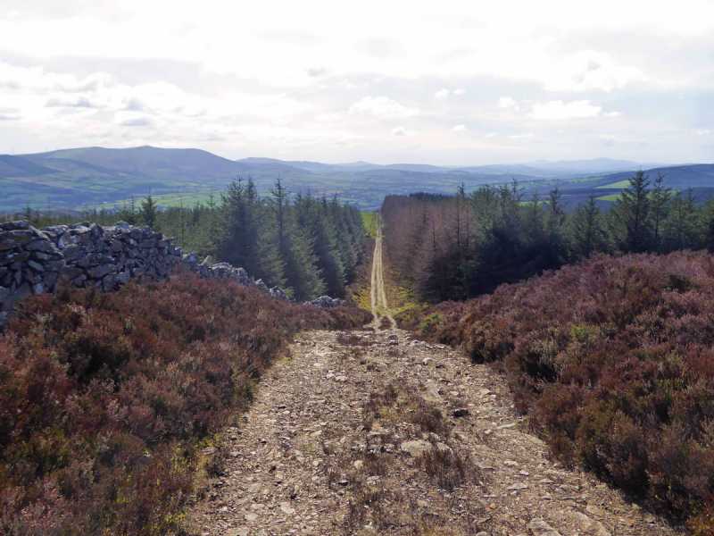
G (T149 833). A rough forest ride extends W from here, and I followed it for about 700 metres, passing a lookout platform similar to one I had seen on Tinoran Hill last year. The going is tough at times here but eventually I reached a forest track at H (T142 834). This track headed S steeply uphill to the summit area of Cushbawn at 
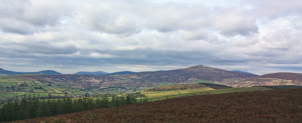
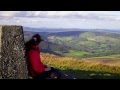
I (T141 830). The views were lovely and the good weather made the Blackstairs shimmer in the haze to the south. I decided to find an alternative route down and so I headed directly E from the summit across heather and downhill towards forestry. By following an old line of fence posts I reached the trees and followed a firebreak down to a forest track at 
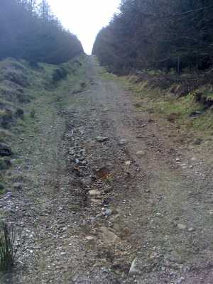
J (T143 829). I turned left and followed it until I came to a point where the track bends and there is a curious little pond/puddle teeming with frogspawn. (K (T147 831)). I walked directly into the trees here and using my compass I headed E for about 250 metres. This section was the usual bending, crawling and branches whipping my face. However I eventually reached the grassy farmland at L (T149 831), emerging from the forest at a rusted cylindrical tank. This was the same meadow reached earlier on the way up so I just retraced my route back to the car from here. The walk was about 2 hours in total. While not the most straightforward route, it provided plenty of challenge in negotiating terrain, navigating through forest and exploring new territory. Be careful using map 62 as it does not depict the forestry on this hill accurately. Linkback: mountainviews.ie/summit/840/comment/3645/
Read Less
Read More

Walk from Ballinaclash
by mickhanney 29 Sep 2018
Cushbawn is also reachable as a walk (or run) from Ballinaclash, perhaps en route to Brook Lodge Macreddin. Park at Ballinaclash and take road that goes steeply uphill at Phelans pub. Stay on this road for a few kilometres. You pass one forest entrance on the left - don't take it. The forest entrance you want is the 2nd one on fhe left, which you encounter after the tarmac road runs out and becomes a rougher quality track. Follow the fire road from the yellow barrier for c. 2 kilometers steadily upwards. At this stage any left turn up through the forest breaks will bring you onto the track that loops around Cushbawn. You might see some marking tape hanging form the trees where a local has marked out a direct line to the Cushbawn track. This short section is quite rough having been left over from previous forest clearing. Once you reach the track through the trees its a left turn then a right turn directly up to Cushbawn summit. Retreat back to Ballinaclash the same way or carry on down past golf club to Brook Lodge for post walk refreshment. Linkback: mountainviews.ie/summit/840/comment/20073/
Read Less
Read More

madfrankie on Cushbawn
by madfrankie 5 Nov 2008
I can only echo what CSD has already said - forestry is far more extensive than depicted on the OS map, particularly on the eastern side and around the summit. We tried a straightforward approach, ascending along the edge of the forestry to the NW. Farmland is very much in evidence, as was deer hunting, with several groups of camouflage-wearing gun-toting predators. Passing the bizarre sight of a severed deer head lying on the ground, we walked up a muddy track to the summit. Our descent west to Macreddan was made more difficult by the difference between tracks indicated on the map and the reality on the ground. Eventually we emerged from forestry at a golf course as the light had almost faded. A half hour walk in the dark back to the car ended a somewhat exasperating afternoon. Linkback: mountainviews.ie/summit/840/comment/3427/
Read Less
Read More
EDIT Point of Interest
text
Videos


Recent Contributions
x
Conditions and Info
Use of MountainViews is governed by conditions and a privacy policy.
Read general information about the site.
Opinions in material here are not necessarily endorsed by MountainViews.
Hillwalking is a risk sport. Information in comments, walks, shared GPS tracks or about starting places may not be accurate for example as regards safety or access permission. You are responsible for your safety and your permission to walk.
See the credits and list definitions.

OSi logo
OSNI/LPS logo
Open Street Map
(Various variations used.)
British summit data courtesy:
Database of British & Irish Hills