Donation Request 2024

DONATE
Members and Supporters, the MountainViews Committee requests your help to meet the costs of the website and of other activities such as insured events or publications.
You do not have to be logged in to donate.
Features
Nearby features appear when you click the map.
Declutter tracks on map.
Place Search
Video
X
Pub: by
Wicklow Area , W: Donard Subarea
Feature count in area: 115, by county: Wicklow: 108, Kildare: 4, Wexford: 2, Carlow: 3, of which 1 is in both Wexford and Wicklow, of which 1 is in both Carlow and Wicklow, OSI/LPS Maps: 28B, 55, 56, 61, 62, AWW, EW-DM, EW-LG, EW-WE, EW-WS
Highest Place: Lugnaquilla 924.7m

Starting Places (205) in area Wicklow:
1916 Memorial Car Park, Aghavannagh Ow Bridge, Aghowle Wood, Altidore Wood Entrance, Annacurra National School, Annalecka Bridge, Asbawn Brook L8350, Aughrim National School, Ballard Road, Ballinabarny Gap, Ballinagappoge Bridge Layby, Ballinagappoge Mountain Hairpin, Ballinagore, Ballinahinch Wood, Ballinastoe MBT CP, Ballinastraw South, Ballineddan Upr Fork, Ballinfoyle Upr Cross, Ballycoog, Ballycreen Brook Bridge, Ballycumber, Ballycumber Bridge, Ballycumber Lane, Ballycumber Wicklow Way, Ballylerane, Ballylow Bridge, Ballylusk Quarry, Ballymanus Lane, Ballymoyle Shooting Lodge, Ballynultagh Gap, Ballynultagh Lane, Ballyreagh Wood, Ballyross Forest, Ballysmuttan Long Stone, Baravore, Barnbawn South, Barranisky North, Barranisky West, Bohilla Land Roundabout, Bohilla Lane Mid, Boranaraltry Bridge, Bray Harbour, Brewel West, Brittas Bay North CP, Buckroney Sand Dunes CP, Bus Terminus, Camera Hill Track Cross, Castletimon Wood North, Clara Vale, Clone House Road, Clonegal, Cloon Wood Cp, Coate Bridge, Coolballintaggart Ledge, Coolbawn House Lane, Cransillagh Brook , Crone Wood CP, Crossbridge, Crossoona Rath, Cummer Wood South, Curtlestown Wood CP, Deputy's Pass CP, Derralossary Church, Derry River Bridge, Devil's Glen CP, Devil's Glen Wood, Djouce Wood Calary, Djouce Wood Lake, Djouce Wood Long Hill, Donard, Donnelly's Lane Car Sales, Drumgoff Forest, Dunranhill North, Dunranhill SE, Dunranhill South, Dwyer McAllister Cottage CP, Enniskerry, Fentons Pub, Fitzsimons Park GAA, unuseableFlemings Footbridge Glen Rd, Gap Pub, Gap Road, Glen Beach CP, Glen of the Downs CP, Glenbride Lane, Glenbride Lodge, Glencree Reconciliation, Glendalough, Glenealy GAA, Glenmacnass Tonelagee CP, Glenmalure Hostel, Glenmalure Lodge, Glenmalure Waterfall, Glenview Hotel, Gowle House, Great Sugar Loaf CP, Grove Bar, Heffernans Well Wood, Hill View, Hollywood Glen, JB Malone CP, Johnnie Fox Pub, Keadeen NE trail, Keadeen Trailhead, Kevins Way Footbridge, Kilbride Army Camp Entrance, Kilcandra South, Kilcommon View, Killalongford Wood, Kilmacrea Cross Roads, Kilranelagh House Gate, Kilruddery Car Park, Kilruddery Cottages, Kings River, Kippure Bridge, Kippure Estate, Kippure Transmitter Gate, Knickeen Cross, Knocknaboley Lane Leeraghs Bog, Knocknaboley Lane Stone Cottage, Knockrath Little, Knockree west, Kyle Loop North, Lackan Wood S, Lake Dr Fraughan Brook, Lake Drive, Lake Park Cross, Lake View Pub, Laragh Free Car Park, Laragh NSch, Lead Mines CP, Liffey Bridge, Liffey Head Bridge, Lough Bray Lower, Lough Bray Upper, Lough Tay North Viewing Point, Lough Tay Wicklow Way CP, Luglass Lane L97561, Lugnagun Track, Macreddin Village, Mangans Lane, Military Road Carrigshouk Hill, Military Road Inchavore River Nth, Military Road Inchavore River Sth, Military Road NW Lough Tay, Military Road Ballyboy Bridge, Military Road Cloghoge Brook, Military Road Croaghanmoira, Military Road Fananierin, Military Road LaraghWicklow Way, Military Road Slieve Maan, Monspolien Bridge, Moortown House, Mountain Rescue HQ, Muskeagh Little Wood, Nahanagan Lough NE, Novara Avenue, Bray, Oiltiagh Brook Knickeen, Old Bridge Cross, Old Bridge Scouts , Old Wicklow Way entrance, Paddock Hill SE, Pier Gates CP, Powerscourt Waterfall CP, Putland Road, Quintagh East, Raheen Park CP, Raheenleagh East, Railway Walk CP, Rathdrum Railway Station, Rednagh Wood, Rocky Valley, Roundwood, Sally Gap, Sally Gap N, Seefin Trailhead, Seskin SE, Shankill Tributary Bridge, Shay Elliott, Sheepshanks Bridge, Shillelagh, Slievecorragh Track, Slievefoore South, Sraghoe Brook, St John's Church, St Kevins Chair, St Kevins Church, St Kevins Way R756, Stone Circle Bridge, Stookeen South, Stranahely Wood, Stranakelly Cross Roads, Tallyho, Templeboden, Tithewer, Tomcoyle L, Tomriland Wood, Toor Brook, Trooperstown Hill Access, Turlough Hill CP, Upper Lake CP, Vallymount GAA CP, Vartry Reservoir Upper, Zellers Pub

Summits & other features in area Wicklow:
Cen: Glendalough North: Brockagh Mountain 556.9m, Brockagh Mountain NW Top 549.5m, Brockagh Mountain SE Top 471.7m, Camaderry East Top 677.3m, Camaderry Mountain 698.6m, Conavalla 734m, Tomaneena 682.4m
Cen: Glendalough South: Carriglineen Mountain 456.6m, Cullentragh Mountain 510m, Derrybawn Mountain 476.1m, Kirikee Mountain 474.5m, Lugduff 653.2m, Lugduff SE Top 638m, Mullacor 660.7m, Trooperstown Hill 430m
N Cen: Tonelagee: Carrignagunneen 561m, Fair Mountain 571.2m, Stoney Top 713.7m, Tonelagee 815.8m, Tonelagee E Top 668m, Tonelagee South-East Top 545.8m
NE: Bray & Kilmacanogue: Bray Head Hill 238.9m, Carrigoona Commons East 242m, Downs Hill 372.9m, Great Sugar Loaf 501.2m, Little Sugar Loaf 342.4m
NE: Djouce: Djouce 725.5m, Knockree 342.1m, Maulin 570m, Tonduff 642m, Tonduff East Top 593m, War Hill 684.8m, White Hill 631.1m
NE: Fancy: Ballinafunshoge 480m, Kanturk 527.4m, Knocknacloghoge 532.4m, Luggala 593.3m, Robber's Pass Hill 508.9m, Scarr 640m, Scarr North-West Top 559.8m, Sleamaine 430m
NE: Vartry: Ballinacorbeg 336m, Ballycurry 301m, Dunranhill 342m, Mount Kennedy 365.9m
NW: Blessington: Carrigleitrim 408m, Lugnagun 446.2m, Slieveroe 332m, Sorrel Hill 599.5m
NW: Mullaghcleevaun: Black Hill 602.2m, Carrigshouk 572.5m, Carrigvore 682.4m, Duff Hill 720.8m, Gravale 719m, Moanbane 703m, Mullaghcleevaun 846.7m, Mullaghcleevaun East Top 796m, Silsean 698m
S: Aughrim Hills: Cushbawn 400m, Killeagh 249m, Moneyteige North 427m, Preban Hill 389m
S: Croaghanmoira: Ballinacor Mountain 529.3m, Ballycurragh Hill 536m, Ballyteige 447m, Carrickashane Mountain 508m, Croaghanmoira 662.3m, Croaghanmoira North Top 579.5m, Fananierin 426m, Slieve Maan 547.8m, Slieve Maan North Top 546.1m
S: Croghan Kinsella: Annagh Hill 454m, Croghan Kinsella 606m, Croghan Kinsella East Top 562.1m, Slievefoore 414m
S: Shillelagh Hills: Lakeen 357m, Monaughrim 206m, Seskin 344m, Stookeen 420m
S: Tinahely Hills: Ballycumber Hill 429.7m, Eagle Hill 296m, Muskeagh Hill 398.2m
SE: Wicklow South East: Ballinastraw 284m, Ballyguile Hill 188m, Barranisky 280m, Carrick Mountain 381m, Collon Hill 238m, Kilnamanagh Hill 217m, Westaston Hill 270m
W: Baltinglass: Ballyhook Hill 288m, Baltinglass Hill 382m, Carrig Mountain 571m, Carrigeen Hill 298m, Cloghnagaune 385m, Corballis Hill 258m, Keadeen Mountain 653m, Spinans Hill 409m, Spinans Hill SE Top 400m, Tinoran Hill 312m
W: Cen Lugnaquilla: Ballineddan Mountain 652.3m, Benleagh 689m, Camenabologue 758m, Camenabologue SE Top 663m, Cloghernagh 800m, Corrigasleggaun 794.6m, Lugnaquilla 924.7m, Slievemaan 759.7m
W: Donard: Brewel Hill 222m, Church Mountain 544m, Corriebracks 531m, Lobawn 636m, Slievecorragh 418m, Sugarloaf 552m, Table Mountain 701.7m, Table Mountain West Top 563m

Note: this list of places may include island features such as summits, but not islands as such.
Rating graphic.
Church Mountain, 544m Mountain Sliabh gCod A name in Irish,
Place Rating ..
(Ir. Sliabh gCod [logainm.ie], 'mountain of [obscure element]') Slieve Gad an extra name in English, Slieve Gadoe, Wicklow County in Leinster province, in Arderin Lists, Church Mountain is the 434th highest place in Ireland.
Grid Reference N94877 01261, OS 1:50k mapsheet 56
Place visited by: 340 members, recently by: Padraigin, KateLeckie, davidrenshaw, MeabhTiernan, Carolyn105, Carolineswalsh, Shaina, MickM45, abacusms, Kaszmirek78, michaelseaver, NualaB, jimmytherabbit, Alanjm, FerdiaScully
I visited this place: NO (You need to be a logged-in member for this.)
Longitude: -6.585862, Latitude: 53.053851, Easting: 294877, Northing: 201261, Prominence: 129m,  Isolation: 2.1km, Has trig pillar
ITM: 694803 701291
Bedrock type: Granite with microcline phenocrysts, (Type 2p microcline porphyritic)
Notes on name: This mountain is first mentioned under the name Sliabh an Chodaigh, 'mountain of the covenant' in a tale dating from before the 12th century. Subsequently the name appears as Sliabh gCod or similar, which is obscure in meaning, unless it is simply a corruption of the earlier form. The site is pre-Christian. There are the remains of a large cairn on top of the mountain. The stones have evidently been scattered into irregular heaps. There is a partially cleared space in the middle, in which there are the foundations of a building, apparently a small ancient church.... Lewis (Topog. Dictionary, 1837, s.v. Donard) says that numerous pilgrims resort to the church on the top of the mountain to visit a well which is close to the walls. This well is still known, and I have heard it called St. Gad's Well by local people [Price, PNCW]. See Máire MacNeill, 'The Festival of Lughnasa' (pp. 96-101) for details of the mountain pilgrimage. Also called Slieve Gad.
  Short or GPS IDs, 6 char: ChrcMn, 10 char: ChrchMntn

Linkback: https://mountainviews.ie/summit/367/
Gallery for Church Mountain (Sliabh gCod) and surrounds
Summary for Church Mountain (Sliabh gCod): Flattish wooded summit with views to the Kildare plains.
Summary created by simon3 2013-06-07 09:09:54
            MountainViews.ie picture about Church Mountain (<em>Sliabh gCod</em>)
Picture: Church Mountain from Lobawn.
This west Wicklow summit can be visited itself for a short up and down walk or will fit into various longer walks. One way of ascending is from around the car park at A (N9343 0239) on the minor road there. Start on a track directly up from there. It is possible to reach it from the east from around Stone Ctg (N9804 0038) taking in Corriebracks. Plan your route carefully through the forestry.
The summit has a number of ruins on top.
Linkback: mountainviews.ie/summit/367/comment/5126/
Member Comments for Church Mountain (Sliabh gCod)
Comment create / edit display placeholder

            MountainViews.ie picture about Church Mountain (<em>Sliabh gCod</em>)
Picture: South-facing side
padodes on Church Mountain
by padodes 1 Oct 2008
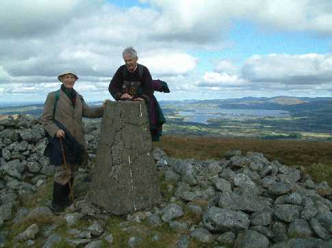
Returning recently to Church Mountain – or Sliabh Gad(oe), or Sliabh an Chodaigh, as it is variously called – I was as intrigued as ever by the size of the cairn on top and its metamorphosis in later times. This finally prompted me to do a little armchair exploration.

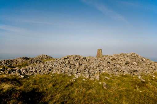
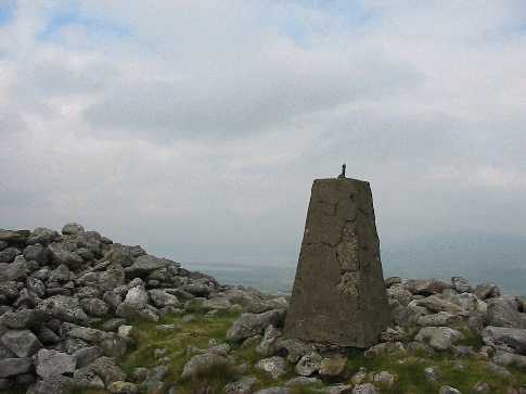
The prehistoric cairn is approximately 25m in diameter and stands 3m high at its most elevated point today. In Christian times, the centre was hollowed out and a little church was built inside. In itself, this is hardly surprising, since it would correspond to the common early Christian practice of ‘baptising’ pagan cultic sites. In the specific case of Church Mountain, historical speculation has been carried a little further. It is known that Palladius, St. Patrick’s less successful predecessor in bringing Christianity to Ireland, came to West Wicklow around 431 AD and established a church there, his second, at a place called ‘Domnacha Arda’. Might not this be the origin of the placename Donard (rather than Dún Ard, as others suggest)? Translated as ‘the church of the high field’, this placename would indicate that Palladius’ chapel was located, not in today’s Donard village, but on the nearby (Church) mountain, atop the cairn or passage grave that was there. Although the vestiges of the church that are visible today – a scant 9 x 6m rectangular outline – are from a later period and dated to the 12th century, it would be reasonable to think that the more recent church will have replaced others, going back to an early Christian structure. One thing, at least, is certain: there has been a long-standing tradition of Christian pilgrimage linked to the mountain. George Petrie, “the father of Irish archaeology”, wrote in 1808 that every year, on Lammas Day (1st August), hundreds of people would ascend the mountain on their knees and a priest recite prayers from the altar, but the practice had ceased after the 1798 rebellion. His friend, the professor of antiquities G. N. Wright, speaks in his “Guide to the County of Wicklow” (1827) of the ruins of a chapel on the summit “where numbers of pilgrims and penitents are constantly to be found, engaged in acts of devotion” and also mentions a holy well, close to the ruined walls, “whose surface is only two feet below the highest point of the mountain, and the spring continues to flow the whole year without much increase or diminution; the water has rather an unpleasant, astringent taste, resembling bog-water, although it is perfectly clear” (p.166).

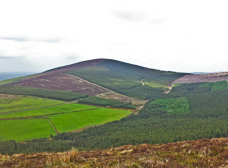
You will look in vain today for pagan spectres or Christian pilgrims on Church Mountain. Personally, I have never met any. They have been replaced by the serried ranks of drab commercial forestry, marching up on all sides. As I saw on my last visit, even the ultimate indignity of quad biking has not been spared the mountain. It is anyone’s guess if it will be allowed to retain into the future a remnant of the character that made it so special in the past. Linkback: mountainviews.ie/summit/367/comment/3346/
Read Less
Read More

            MountainViews.ie picture about Church Mountain (<em>Sliabh gCod</em>)
Picture: Summit with Cairn
dunnejohn on Church Mountain
by dunnejohn 3 Apr 2009
I recently hiked Church Mountain with my wife and daughter - it was a nice family day out for Mothers Day! We came from Dublin and took a nice drive through the Hollywood Glen, before turning left at Hell Kettle Br.
At the end of the laneway where the track begins you end up in farmyard with several farm buidings and farmhouse (OS sheet 56, GR B (S946 993)). For anyone planning approaching the hill from here, it's a good idea to check with the farmer if it's ok to park there, as it's a bit tight for space. We did, and found him to be a very friendly and helpful gent.
As mentioned by csd in his comment, the forestry plantation is now much more extensive than marked on the map, currently extending to approx. GR C (S953 999) on the map. Here a track runs uphill due west along the perimeter fence of the forestry plantation, before turning due north, again staying along the border of the forestry, at approx. GR D (S951 999), and then runs along the ridge that runs north/south along the spine of the mountain (there's a conveniently placed bench at this point if you're out of breath from the steep hike from the main track!).
From here it's a gentle ascent along a dead straight track until near the summit. As you approach the summit the terrain flattens a little, and it may be tempting to leave the track and head accross the heather to find the cairn and triangulation pillar. Dont!! There's a much easier way. Keey your eyes open for the stones arranged in the shape of a cross on your right, at the edge of the forestry fence (it's beside a fence post which is supported by a couple of large rocks). The bottom point of the cross points roughly NW - let your eye follow this direction, and you will see the old eroded trail which leads directly to the summit.
Beside the extensive Cairn, atop of which sits the trig. pillar, there's a lovely stone bench erected in memory of a local man. Nice to take a seat and take in the view NE. If you need a more sheltered place to sit, on the SW side of the Cairn there's a stone enclosure with some flat rocks ideal for sitting out of the wind and enjoying that well deserved cup of tea! Cheers! Linkback: mountainviews.ie/summit/367/comment/3698/
Read Less
Read More

            MountainViews.ie picture about Church Mountain (<em>Sliabh gCod</em>)
csd on Church Mountain
by csd 22 Jun 2003
Church Mountain offers some great views over west Wicklow and the southern Wicklow Mountains. If coming from Corriebracks, access to the summit can be gained by way of an eroded track that runs up the firebreak on the eastern slopes. The conifer plantation is now much more extensive than shown on Sheet 56, covering most of the eastern side of the mountain. There are a trig pillar and the remains of a prehistoric cairn at the summit (see pic). Linkback: mountainviews.ie/summit/367/comment/561/
Read Less
Read More

            MountainViews.ie picture about Church Mountain (<em>Sliabh gCod</em>)
GWPR on Church Mountain
by GWPR 30 Oct 2003
Trig. Pillar on Church Mt. with Blessington Lakes in background. Oct 2003. Linkback: mountainviews.ie/summit/367/comment/731/
Read Less
Read More

Different Ways Up
by Pepe 23 Jul 2016
I started from A (N9343 0239) and followed the forestry track. Somehow though I took a wrong turning (on an inviting looking greenway path) and found myself at a dead end in the forestry. Luckily though I was less than a 100 yards from the forest edge. I made for the obvious sunlight through the trees and emerged with the forest on my left. The route up from here is obvious, though it entailed getting over a barbed wire fence. On the other side of the fence a very rough track (of sorts) helped me ascend to where I found the track I should have been on in the first place. Linkback: mountainviews.ie/summit/367/comment/18599/
Read Less
Read More
EDIT Point of Interest
text
Videos


Recent Contributions
x
Conditions and Info
Use of MountainViews is governed by conditions and a privacy policy.
Read general information about the site.
Opinions in material here are not necessarily endorsed by MountainViews.
Hillwalking is a risk sport. Information in comments, walks, shared GPS tracks or about starting places may not be accurate for example as regards safety or access permission. You are responsible for your safety and your permission to walk.
See the credits and list definitions.

OSi logo
OSNI/LPS logo
Open Street Map
(Various variations used.)
British summit data courtesy:
Database of British & Irish Hills