Members and Supporters, the MountainViews Committee requests your help to meet the costs of the website and of other activities such as insured events or publications.
Feature count in area: 115, by county: Wicklow: 108, Kildare: 4, Wexford: 2, Carlow: 3, of which 1 is in both Wexford and Wicklow, of which 1 is in both Carlow and Wicklow,
OSI/LPS Maps: 28B, 55, 56, 61, 62, AWW, EW-DM, EW-LG, EW-WE, EW-WS
Highest Place: Lugnaquilla 924.7m
Starting Places (205) in area Wicklow: 1916 Memorial Car Park, Aghavannagh Ow Bridge, Aghowle Wood, Altidore Wood Entrance, Annacurra National School, Annalecka Bridge, Asbawn Brook L8350, Aughrim National School, Ballard Road, Ballinabarny Gap, Ballinagappoge Bridge Layby, Ballinagappoge Mountain Hairpin, Ballinagore, Ballinahinch Wood, Ballinastoe MBT CP, Ballinastraw South, Ballineddan Upr Fork, Ballinfoyle Upr Cross, Ballycoog, Ballycreen Brook Bridge, Ballycumber, Ballycumber Bridge, Ballycumber Lane, Ballycumber Wicklow Way, Ballylerane, Ballylow Bridge, Ballylusk Quarry, Ballymanus Lane, Ballymoyle Shooting Lodge, Ballynultagh Gap, Ballynultagh Lane, Ballyreagh Wood, Ballyross Forest, Ballysmuttan Long Stone, Baravore, Barnbawn South, Barranisky North, Barranisky West, Bohilla Land Roundabout, Bohilla Lane Mid, Boranaraltry Bridge, Bray Harbour, Brewel West, Brittas Bay North CP, Buckroney Sand Dunes CP, Bus Terminus, Camera Hill Track Cross, Castletimon Wood North, Clara Vale, Clone House Road, Clonegal, Cloon Wood Cp, Coate Bridge, Coolballintaggart Ledge, Coolbawn House Lane, Cransillagh Brook , Crone Wood CP, Crossbridge, Crossoona Rath, Cummer Wood South, Curtlestown Wood CP, Deputy's Pass CP, Derralossary Church, Derry River Bridge, Devil's Glen CP, Devil's Glen Wood, Djouce Wood Calary, Djouce Wood Lake, Djouce Wood Long Hill, Donard, Donnelly's Lane Car Sales, Drumgoff Forest, Dunranhill North, Dunranhill SE, Dunranhill South, Dwyer McAllister Cottage CP, Enniskerry, Fentons Pub, Fitzsimons Park GAA, unuseableFlemings Footbridge Glen Rd, Gap Pub, Gap Road, Glen Beach CP, Glen of the Downs CP, Glenbride Lane, Glenbride Lodge, Glencree Reconciliation, Glendalough, Glenealy GAA, Glenmacnass Tonelagee CP, Glenmalure Hostel, Glenmalure Lodge, Glenmalure Waterfall, Glenview Hotel, Gowle House, Great Sugar Loaf CP, Grove Bar, Heffernans Well Wood, Hill View, Hollywood Glen, JB Malone CP, Johnnie Fox Pub, Keadeen NE trail, Keadeen Trailhead, Kevins Way Footbridge, Kilbride Army Camp Entrance, Kilcandra South, Kilcommon View, Killalongford Wood, Kilmacrea Cross Roads, Kilranelagh House Gate, Kilruddery Car Park, Kilruddery Cottages, Kings River, Kippure Bridge, Kippure Estate, Kippure Transmitter Gate, Knickeen Cross, Knocknaboley Lane Leeraghs Bog, Knocknaboley Lane Stone Cottage, Knockrath Little, Knockree west, Kyle Loop North, Lackan Wood S, Lake Dr Fraughan Brook, Lake Drive, Lake Park Cross, Lake View Pub, Laragh Free Car Park, Laragh NSch, Lead Mines CP, Liffey Bridge, Liffey Head Bridge, Lough Bray Lower, Lough Bray Upper, Lough Tay North Viewing Point, Lough Tay Wicklow Way CP, Luglass Lane L97561, Lugnagun Track, Macreddin Village, Mangans Lane, Military Road Carrigshouk Hill, Military Road Inchavore River Nth, Military Road Inchavore River Sth, Military Road NW Lough Tay, Military Road Ballyboy Bridge, Military Road Cloghoge Brook, Military Road Croaghanmoira, Military Road Fananierin, Military Road LaraghWicklow Way, Military Road Slieve Maan, Monspolien Bridge, Moortown House, Mountain Rescue HQ, Muskeagh Little Wood, Nahanagan Lough NE, Novara Avenue, Bray, Oiltiagh Brook Knickeen, Old Bridge Cross, Old Bridge Scouts , Old Wicklow Way entrance, Paddock Hill SE, Pier Gates CP, Powerscourt Waterfall CP, Putland Road, Quintagh East, Raheen Park CP, Raheenleagh East, Railway Walk CP, Rathdrum Railway Station, Rednagh Wood, Rocky Valley, Roundwood, Sally Gap, Sally Gap N, Seefin Trailhead, Seskin SE, Shankill Tributary Bridge, Shay Elliott, Sheepshanks Bridge, Shillelagh, Slievecorragh Track, Slievefoore South, Sraghoe Brook, St John's Church, St Kevins Chair, St Kevins Church, St Kevins Way R756, Stone Circle Bridge, Stookeen South, Stranahely Wood, Stranakelly Cross Roads, Tallyho, Templeboden, Tithewer, Tomcoyle L, Tomriland Wood, Toor Brook, Trooperstown Hill Access, Turlough Hill CP, Upper Lake CP, Vallymount GAA CP, Vartry Reservoir Upper, Zellers Pub
Summits & other features in area Wicklow: Cen: Glendalough North: Brockagh Mountain 556.9m, Brockagh Mountain NW Top 549.5m, Brockagh Mountain SE Top 471.7m, Camaderry East Top 677.3m, Camaderry Mountain 698.6m, Conavalla 734m, Tomaneena 682.4m Cen: Glendalough South: Carriglineen Mountain 456.6m, Cullentragh Mountain 510m, Derrybawn Mountain 476.1m, Kirikee Mountain 474.5m, Lugduff 653.2m, Lugduff SE Top 638m, Mullacor 660.7m, Trooperstown Hill 430m N Cen: Tonelagee: Carrignagunneen 561m, Fair Mountain 571.2m, Stoney Top 713.7m, Tonelagee 815.8m, Tonelagee E Top 668m, Tonelagee South-East Top 545.8m NE: Bray & Kilmacanogue: Bray Head Hill 238.9m, Carrigoona Commons East 242m, Downs Hill 372.9m, Great Sugar Loaf 501.2m, Little Sugar Loaf 342.4m NE: Djouce: Djouce 725.5m, Knockree 342.1m, Maulin 570m, Tonduff 642m, Tonduff East Top 593m, War Hill 684.8m, White Hill 631.1m NE: Fancy: Ballinafunshoge 480m, Kanturk 527.4m, Knocknacloghoge 532.4m, Luggala 593.3m, Robber's Pass Hill 508.9m, Scarr 640m, Scarr North-West Top 559.8m, Sleamaine 430m NE: Vartry: Ballinacorbeg 336m, Ballycurry 301m, Dunranhill 342m, Mount Kennedy 365.9m NW: Blessington: Carrigleitrim 408m, Lugnagun 446.2m, Slieveroe 332m, Sorrel Hill 599.5m NW: Mullaghcleevaun: Black Hill 602.2m, Carrigshouk 572.5m, Carrigvore 682.4m, Duff Hill 720.8m, Gravale 719m, Moanbane 703m, Mullaghcleevaun 846.7m, Mullaghcleevaun East Top 796m, Silsean 698m S: Aughrim Hills: Cushbawn 400m, Killeagh 249m, Moneyteige North 427m, Preban Hill 389m S: Croaghanmoira: Ballinacor Mountain 529.3m, Ballycurragh Hill 536m, Ballyteige 447m, Carrickashane Mountain 508m, Croaghanmoira 662.3m, Croaghanmoira North Top 579.5m, Fananierin 426m, Slieve Maan 547.8m, Slieve Maan North Top 546.1m S: Croghan Kinsella: Annagh Hill 454m, Croghan Kinsella 606m, Croghan Kinsella East Top 562.1m, Slievefoore 414m S: Shillelagh Hills: Lakeen 357m, Monaughrim 206m, Seskin 344m, Stookeen 420m S: Tinahely Hills: Ballycumber Hill 429.7m, Eagle Hill 296m, Muskeagh Hill 398.2m SE: Wicklow South East: Ballinastraw 284m, Ballyguile Hill 188m, Barranisky 280m, Carrick Mountain 381m, Collon Hill 238m, Kilnamanagh Hill 217m, Westaston Hill 270m W: Baltinglass: Ballyhook Hill 288m, Baltinglass Hill 382m, Carrig Mountain 571m, Carrigeen Hill 298m, Cloghnagaune 385m, Corballis Hill 258m, Keadeen Mountain 653m, Spinans Hill 409m, Spinans Hill SE Top 400m, Tinoran Hill 312m W: Cen Lugnaquilla: Ballineddan Mountain 652.3m, Benleagh 689m, Camenabologue 758m, Camenabologue SE Top 663m, Cloghernagh 800m, Corrigasleggaun 794.6m, Lugnaquilla 924.7m, Slievemaan 759.7m W: Donard: Brewel Hill 222m, Church Mountain 544m, Corriebracks 531m, Lobawn 636m, Slievecorragh 418m, Sugarloaf 552m, Table Mountain 701.7m, Table Mountain West Top 563m
Note: this list of places may include island features such as summits, but not
islands as such.
Camenabologue, 758mMountain Céim na mBulóg A name in Irish,
Place Rating ..
(Ir. Céim na mBulóg [PNCW], 'step/pass of the bullocks'), Leoh Mountain, White Brow, Wicklow County in Leinster province, in Arderin, Vandeleur-Lynam, Irish Highest Hundred Lists, Camenabologue is the 72nd highest place in Ireland.
Grid Reference T02321 95992,
OS 1:50k mapsheet 56 Place visited by: 652members, recently by: andodenis, Hjonna, Courin, rhw, Sophie-Hayes, MartMc, MeabhTiernan, maoris, davidrenshaw, Magic, Prem, Carolineswalsh, ConMack23, MarionP, ToughSoles
I visited this place: NO (You need to be a logged-in member for this.)
Short or GPS IDs, 6 char: Cmnblg, 10 char: Cmnblg Linkback: https://mountainviews.ie/summit/71/
Gallery for Camenabologue (Céim na mBulóg) and surrounds
Summary
for Camenabologue (Céim na mBulóg):
Nondescript hill with a lonely and wild feel.
Summary created by markmjcampion, wicklore
2023-08-31 11:46:12
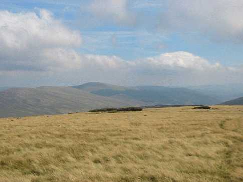
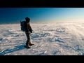
Picture: Camenabologue from Seskin
Camenabologue is an isolated, rounded, boggy hill at the S end of the National Park. Its summit lies close to Table Track so access is straightforward. Views are normally fairly local incl Wicklow’s 3 highest - Lugnaquilia, Tonelagee and Mullaghcleevaun. On a clear day, the Blackstairs and Slievanamon come into focus.
SE. Starting in Glenmalure at the large cp B'vore (T06625 94176), walk across the bridge and follow the Coillte track NW for several k until you reach a junction at A (T03458 96141) which heads up over open bog. This bog track, interspersed with short pieces of wooden boardwalk over the worst boggy sections, leads to the col between Table Mountain and Camenabologue at B (T02085 96698). Leave the Table Track and walk S. From here it is an easy 10 minute ramble to the summit. 6.5k 2hrs
SE. From the same start it can also be arrived at via the captivating Fraughan Rock Glen and Benleagh…see track/3444
W. This hill is also included in a fine circuit around the Glen of Imaal incorporating Lugnaquilla and Table Mt. and potentially Lobawn and Sugarloaf. This generally starts at Fenton’s Pub Fentons (S97307 93552)…for more info check the Lugnaquilla page. Take note of Army Rifle Range active shooting times.
E. It’s also possible to do a long circuit of sorts from GMlur Wf (T08072 92782), first taking in Mullacor and Conavalla and returning by way of the forest track mentioned above. The full circuit is 7hrs+
Notable tracks include track/3368 and the long loops track/2334 and track/3069.
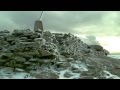
Just to prove you can get good views from Camenabologue, here's a shot from the summit looking over to Lugduff and Mullacor. Note the grass - makes a change from the bog that covers much of the surrounding summits. Camenabologue is nice in that it's high enough to command good views of the surrounding area but not so high as to be permanently shrouded in mist (as Lugnaquilla always seems to be!). Linkback: mountainviews.ie/summit/71/comment/642/
Read Less
Read More
simon3 on Camenabologue
by simon3
18 Nov 2002
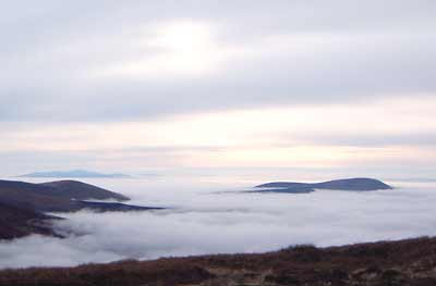
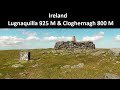
One Sunday in November 2002 there was a strong temperature inversion, leaving the top of the clouds at around 400m. Looking South West from near the summit of Camenabologue there was a clear view of nearby Keadeen (653m) and Carrig mountains (right of the picture). At the left of the picture the slopes of Slievemaan partly obscure the ridgy bump of Ballinedan (652m). On the horizon are the peaks of the Blackstairs with Mount Leinster (795m and 55k away) the most prominent. Linkback: mountainviews.ie/summit/71/comment/223/
Read Less
Read More
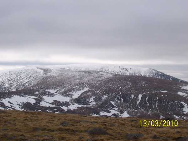
Picture: Lug as viewed from Camenabologue
darrenf on Camenabologue
by darrenf
15 Mar 2010
From Benleagh I tramped on toward SH626 (refer to Benleagh for start of route). I found the going to be very boggy, even with the recent frost, ice and snow packed on the ground. The constant trudging up and down over peat hags was also tiresome. But all of this paled into insignifigance when I stumbled upon a herd of some 15 deer. I knew there was a reason why I broke away from the pack heading for Lug! I continued on toward Camenabologue with views over Turlough Hill and Camaderry with me every step of the way. It wasnt long before I reached the carin on Camenabologue. Compared to some other summits in the area Camenabologue is somewhat uninspiring. Perhaps its a reflection on the calibre of its neighbours.
A short hop the far side of Camenabologue will take you to the well worn track leading right down into the Glenmalur valley. There is evidence of scrambler bike and quad use in and around the vicinty of the track. Sections of boardwalk are dotted along the top section of the track. Given the state of the ground between these sections of boardwalk perhaps there is an arguement for further work to take place up here. Anything that may lead to the protection and preservation of the landscape and terrain can only be a good thing, once it is carried out in haramony with the surrounding landscape. There is obviously a counter arguement here that this level of infrastructure also provides better access for our scrambler friends, but hey some probelms are easier to erradicate than others!! This track brings you right down the Glenmalur valley and back to the Barravore carpark. There is plenty of tree felling in progress underway at various sections along the track and care should be taken. An enjoyable walk all in all with 16km clocked up in total. One which could be used as an alternative to the sometimes crowded Lugnaquilla. Linkback: mountainviews.ie/summit/71/comment/4507/
Read Less
Read More
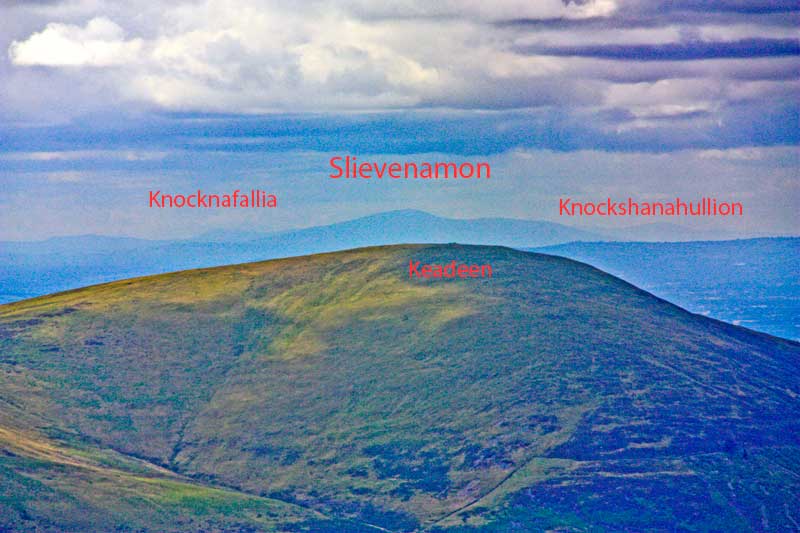
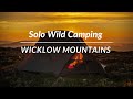
Picture: Keadeen from Camenabologue.
Distant views around Keadeen identified.
by simon3
12 Aug 2013
The views from Camenabologue have been mentioned before. Here's one way of identifying some distant peaks on a good day. First find Keadeen, the 653m summit to the west of Lugnaquillia. It's at about 229.5 degrees (great circle, not magnetic). It lines up with the Slievenamon - Knocknahunna ridge. Slievenamon (721m) is around 97.5km away at 229.2 degrees.
Slievenamon is basically sitting in the way of a good view of the Knockmealdowns, however you can see Knocknafallia (668m) to the east and Knockshanahullion (652) to the west at distances of 128.4 and 133.3km respectively. Linkback: mountainviews.ie/summit/71/comment/15066/
Read Less
Read More
bob mologna on Camenabologue
by bob mologna
8 Sep 2003
It isn't much of a destination in itself but it makes a nice waypoint on a longer loop. When you get to the summit you kind of wonder why you bothered. I just did it in a nice little loop starting at Glenmalure Lodge going up Corrigasleggaun > Carrawaystick > Lugnaquillia > Benleagh > Camenabologue and back down the trail to the hostel / road home. The weather was very wet and visibility was variable (mostly VERY poor). I saw a group of about 25 or 30 deer quite close up between Benleagh and Camenabologue and I surprised a couple of deer in the fog coming down Benleagh very close (10 metres or so). It's a great hike in bad weather but it's probably best if you're already familiar with it. Linkback: mountainviews.ie/summit/71/comment/633/
Use of MountainViews is governed by conditions and a privacy policy.
Read general information about the site. Opinions in material here are not necessarily endorsed by MountainViews.
Hillwalking is a risk sport. Information in comments, walks, shared GPS tracks or about starting places may
not be accurate for example as regards safety or access permission. You are responsible for your safety and your permission to walk.
See the credits and list definitions.


 Our Facebook page.