Donation Request 2024

DONATE
Members and Supporters, the MountainViews Committee requests your help to meet the costs of the website and of other activities such as insured events or publications.
You do not have to be logged in to donate.
Features
Nearby features appear when you click the map.
Declutter tracks on map.
Place Search
Video
X
Pub: by
Wicklow Area , Cen: Glendalough South Subarea
Feature count in area: 115, by county: Wicklow: 108, Kildare: 4, Wexford: 2, Carlow: 3, of which 1 is in both Wexford and Wicklow, of which 1 is in both Carlow and Wicklow, OSI/LPS Maps: 28B, 55, 56, 61, 62, AWW, EW-DM, EW-LG, EW-WE, EW-WS
Highest Place: Lugnaquilla 924.7m

Starting Places (205) in area Wicklow:
1916 Memorial Car Park, Aghavannagh Ow Bridge, Aghowle Wood, Altidore Wood Entrance, Annacurra National School, Annalecka Bridge, Asbawn Brook L8350, Aughrim National School, Ballard Road, Ballinabarny Gap, Ballinagappoge Bridge Layby, Ballinagappoge Mountain Hairpin, Ballinagore, Ballinahinch Wood, Ballinastoe MBT CP, Ballinastraw South, Ballineddan Upr Fork, Ballinfoyle Upr Cross, Ballycoog, Ballycreen Brook Bridge, Ballycumber, Ballycumber Bridge, Ballycumber Lane, Ballycumber Wicklow Way, Ballylerane, Ballylow Bridge, Ballylusk Quarry, Ballymanus Lane, Ballymoyle Shooting Lodge, Ballynultagh Gap, Ballynultagh Lane, Ballyreagh Wood, Ballyross Forest, Ballysmuttan Long Stone, Baravore, Barnbawn South, Barranisky North, Barranisky West, Bohilla Land Roundabout, Bohilla Lane Mid, Boranaraltry Bridge, Bray Harbour, Brewel West, Brittas Bay North CP, Buckroney Sand Dunes CP, Bus Terminus, Camera Hill Track Cross, Castletimon Wood North, Clara Vale, Clone House Road, Clonegal, Cloon Wood Cp, Coate Bridge, Coolballintaggart Ledge, Coolbawn House Lane, Cransillagh Brook , Crone Wood CP, Crossbridge, Crossoona Rath, Cummer Wood South, Curtlestown Wood CP, Deputy's Pass CP, Derralossary Church, Derry River Bridge, Devil's Glen CP, Devil's Glen Wood, Djouce Wood Calary, Djouce Wood Lake, Djouce Wood Long Hill, Donard, Donnelly's Lane Car Sales, Drumgoff Forest, Dunranhill North, Dunranhill SE, Dunranhill South, Dwyer McAllister Cottage CP, Enniskerry, Fentons Pub, Fitzsimons Park GAA, unuseableFlemings Footbridge Glen Rd, Gap Pub, Gap Road, Glen Beach CP, Glen of the Downs CP, Glenbride Lane, Glenbride Lodge, Glencree Reconciliation, Glendalough, Glenealy GAA, Glenmacnass Tonelagee CP, Glenmalure Hostel, Glenmalure Lodge, Glenmalure Waterfall, Glenview Hotel, Gowle House, Great Sugar Loaf CP, Grove Bar, Heffernans Well Wood, Hill View, Hollywood Glen, JB Malone CP, Johnnie Fox Pub, Keadeen NE trail, Keadeen Trailhead, Kevins Way Footbridge, Kilbride Army Camp Entrance, Kilcandra South, Kilcommon View, Killalongford Wood, Kilmacrea Cross Roads, Kilranelagh House Gate, Kilruddery Car Park, Kilruddery Cottages, Kings River, Kippure Bridge, Kippure Estate, Kippure Transmitter Gate, Knickeen Cross, Knocknaboley Lane Leeraghs Bog, Knocknaboley Lane Stone Cottage, Knockrath Little, Knockree west, Kyle Loop North, Lackan Wood S, Lake Dr Fraughan Brook, Lake Drive, Lake Park Cross, Lake View Pub, Laragh Free Car Park, Laragh NSch, Lead Mines CP, Liffey Bridge, Liffey Head Bridge, Lough Bray Lower, Lough Bray Upper, Lough Tay North Viewing Point, Lough Tay Wicklow Way CP, Luglass Lane L97561, Lugnagun Track, Macreddin Village, Mangans Lane, Military Road Carrigshouk Hill, Military Road Inchavore River Nth, Military Road Inchavore River Sth, Military Road NW Lough Tay, Military Road Ballyboy Bridge, Military Road Cloghoge Brook, Military Road Croaghanmoira, Military Road Fananierin, Military Road LaraghWicklow Way, Military Road Slieve Maan, Monspolien Bridge, Moortown House, Mountain Rescue HQ, Muskeagh Little Wood, Nahanagan Lough NE, Novara Avenue, Bray, Oiltiagh Brook Knickeen, Old Bridge Cross, Old Bridge Scouts , Old Wicklow Way entrance, Paddock Hill SE, Pier Gates CP, Powerscourt Waterfall CP, Putland Road, Quintagh East, Raheen Park CP, Raheenleagh East, Railway Walk CP, Rathdrum Railway Station, Rednagh Wood, Rocky Valley, Roundwood, Sally Gap, Sally Gap N, Seefin Trailhead, Seskin SE, Shankill Tributary Bridge, Shay Elliott, Sheepshanks Bridge, Shillelagh, Slievecorragh Track, Slievefoore South, Sraghoe Brook, St John's Church, St Kevins Chair, St Kevins Church, St Kevins Way R756, Stone Circle Bridge, Stookeen South, Stranahely Wood, Stranakelly Cross Roads, Tallyho, Templeboden, Tithewer, Tomcoyle L, Tomriland Wood, Toor Brook, Trooperstown Hill Access, Turlough Hill CP, Upper Lake CP, Vallymount GAA CP, Vartry Reservoir Upper, Zellers Pub

Summits & other features in area Wicklow:
Cen: Glendalough North: Brockagh Mountain 556.9m, Brockagh Mountain NW Top 549.5m, Brockagh Mountain SE Top 471.7m, Camaderry East Top 677.3m, Camaderry Mountain 698.6m, Conavalla 734m, Tomaneena 682.4m
Cen: Glendalough South: Carriglineen Mountain 456.6m, Cullentragh Mountain 510m, Derrybawn Mountain 476.1m, Kirikee Mountain 474.5m, Lugduff 653.2m, Lugduff SE Top 638m, Mullacor 660.7m, Trooperstown Hill 430m
N Cen: Tonelagee: Carrignagunneen 561m, Fair Mountain 571.2m, Stoney Top 713.7m, Tonelagee 815.8m, Tonelagee E Top 668m, Tonelagee South-East Top 545.8m
NE: Bray & Kilmacanogue: Bray Head Hill 238.9m, Carrigoona Commons East 242m, Downs Hill 372.9m, Great Sugar Loaf 501.2m, Little Sugar Loaf 342.4m
NE: Djouce: Djouce 725.5m, Knockree 342.1m, Maulin 570m, Tonduff 642m, Tonduff East Top 593m, War Hill 684.8m, White Hill 631.1m
NE: Fancy: Ballinafunshoge 480m, Kanturk 527.4m, Knocknacloghoge 532.4m, Luggala 593.3m, Robber's Pass Hill 508.9m, Scarr 640m, Scarr North-West Top 559.8m, Sleamaine 430m
NE: Vartry: Ballinacorbeg 336m, Ballycurry 301m, Dunranhill 342m, Mount Kennedy 365.9m
NW: Blessington: Carrigleitrim 408m, Lugnagun 446.2m, Slieveroe 332m, Sorrel Hill 599.5m
NW: Mullaghcleevaun: Black Hill 602.2m, Carrigshouk 572.5m, Carrigvore 682.4m, Duff Hill 720.8m, Gravale 719m, Moanbane 703m, Mullaghcleevaun 846.7m, Mullaghcleevaun East Top 796m, Silsean 698m
S: Aughrim Hills: Cushbawn 400m, Killeagh 249m, Moneyteige North 427m, Preban Hill 389m
S: Croaghanmoira: Ballinacor Mountain 529.3m, Ballycurragh Hill 536m, Ballyteige 447m, Carrickashane Mountain 508m, Croaghanmoira 662.3m, Croaghanmoira North Top 579.5m, Fananierin 426m, Slieve Maan 547.8m, Slieve Maan North Top 546.1m
S: Croghan Kinsella: Annagh Hill 454m, Croghan Kinsella 606m, Croghan Kinsella East Top 562.1m, Slievefoore 414m
S: Shillelagh Hills: Lakeen 357m, Monaughrim 206m, Seskin 344m, Stookeen 420m
S: Tinahely Hills: Ballycumber Hill 429.7m, Eagle Hill 296m, Muskeagh Hill 398.2m
SE: Wicklow South East: Ballinastraw 284m, Ballyguile Hill 188m, Barranisky 280m, Carrick Mountain 381m, Collon Hill 238m, Kilnamanagh Hill 217m, Westaston Hill 270m
W: Baltinglass: Ballyhook Hill 288m, Baltinglass Hill 382m, Carrig Mountain 571m, Carrigeen Hill 298m, Cloghnagaune 385m, Corballis Hill 258m, Keadeen Mountain 653m, Spinans Hill 409m, Spinans Hill SE Top 400m, Tinoran Hill 312m
W: Cen Lugnaquilla: Ballineddan Mountain 652.3m, Benleagh 689m, Camenabologue 758m, Camenabologue SE Top 663m, Cloghernagh 800m, Corrigasleggaun 794.6m, Lugnaquilla 924.7m, Slievemaan 759.7m
W: Donard: Brewel Hill 222m, Church Mountain 544m, Corriebracks 531m, Lobawn 636m, Slievecorragh 418m, Sugarloaf 552m, Table Mountain 701.7m, Table Mountain West Top 563m

Note: this list of places may include island features such as summits, but not islands as such.
Rating graphic.
Trooperstown Hill, 430m Hill Maoilín A name in Irish,
Place Rating ..
(Ir. Maoilín [OSI], 'little round hill'), Mweeleen, Wicklow County in Leinster province, in Carn Lists, Trooperstown Hill is the 805th highest place in Ireland.
Grid Reference T16620 95200, OS 1:50k mapsheet 56
Place visited by: 253 members, recently by: rogers, Kaszmirek78, NualaB, MariaT, michaelseaver, markv, Beti13, lauracardiff, SenanFoley, Dee68, megk971, arthurdoylephoto, Ansarlodge, GerryCarroll, Wilderness
I visited this place: NO (You need to be a logged-in member for this.)
Longitude: -6.264062, Latitude: 52.995401, Easting: 316620, Northing: 195200, Prominence: 251m,  Isolation: 4.7km
ITM: 716532 695262
Bedrock type: Dark blue-grey slate, phyllite & schist, (Maulin Formation)

  Short or GPS IDs, 6 char: TrprHl, 10 char: TrprstwHil

Linkback: https://mountainviews.ie/summit/689/
Gallery for Trooperstown Hill (Maoilín) and surrounds
Summary for Trooperstown Hill (Maoilín): A good place to view the Wicklow Mountains
Summary created by mcrtchly 2011-01-17 23:54:47
Trooperstown Hill is one of the westerly outposts of the Wicklow Mountains and as such it gives good views of much of the surrounding hills to the west, north and south. On clear days the Wicklow coast can be seen to the east and maybe the Welsh Mountains beyond.

There are two principal points of access. The first option is to take the Military road (R755) south from Laragh and take a left turn before Bookey Bridge and another left turn up an unsurfaced road after about 1km. Parking at a junction at A (T1558 9540) about 800m along the unsurfaced road. From here a rough track/path on the right heads SE to the junction after about 1km at the southern end of the hill (B (T165 947)) where you turn left and head to the summit which is reached after a further 500m. The time to the top and back is about 1.5hrs. The second option is either to continue along the unsurfaced road and park on the right just before the obvious phone mast at Troop (T163 961). This point can also be reached from the north on minor roads from the R763. From this point a short steep track/path leads to the summit which is reached in about 20-25mins. Either walk is not too boggy but the paths have been churned up in places by quad bikes.

A third option would be to park at the car park near the Parks HQ at MtRs (T159 969) and take the path across the Avonmore River then turn left and follow the path up through the forest until reaching the road near to the phone mast. Turn right here and follow second route to the summit.
Linkback: mountainviews.ie/summit/689/comment/5448/
Member Comments for Trooperstown Hill (Maoilín)
Comment create / edit display placeholder

            MountainViews.ie picture about Trooperstown Hill (<em>Maoilín</em>)
padodes on Trooperstown Hill
by padodes 24 Mar 2008
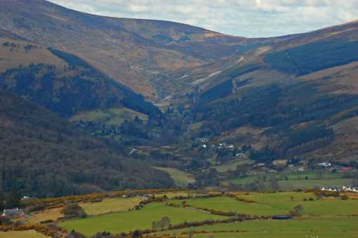
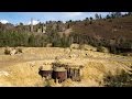
Unlike all too many of the 400m hills in Wicklow, small outliers plagued with dense forest, Trooperstown (Maolín) is well worth the short climb. Any glance at the map shows why. It is like the centre of a fan, with the long ribs of the eastern mountains descending towards it, their colourful valleys in between, especially Glenmacnass, Glendasan and the entrance to Glendalough (visible in the photo). A whole array of well-known peaks are distinguishable, from the white triangle of the Great Sugar Loaf in the north to the equally recognisable triangle of Croaghanmoira in the south, peeping over the shoulder of Kirikee. In between, there are splendid views of Scarr, Tonelagee,Camaderry, Derrybawn, to name but a few. Even the summit of distant Lugnaquillia is within range. It’s easy to get to Trooperstown Hill. Just south of Laragh, take a left turn before Bookey Bridge and about a kilometre on take a left turn up an unsurfaced road (with care, if you don’t want to risk an axle!). Parking at A (T1558 9540), you’ll see a rutted track to the right, that winds up towards the top at C (T1664 9527). The obvious place to go from here is to the connected 396m top at D (T1774 9462) and then on to the 340m top just south, if you contour around the back of the forest. It’s a nice walk down to Clara from here, if you can arrange a second car to meet you. If not, there are so many tracks across these tops that you can follow all kinds of permutations and combinations to get you back to the start without having to retrace your steps. Unfortunately, the terrible quads have also discovered the all-too-accessible beauty of this area and many of the tracks are theirs. Linkback: mountainviews.ie/summit/689/comment/3015/
Read Less
Read More

An Overgrowth of Furze at Clarabeg
by jgfitz 27 Mar 2019
On 21/4/19, our group hiked Trooperstown Hill, followed the uploaded track #868. This was an excellent hike until we reached E (T1842 9268), the point at which the track turns due west. Unfortunately, what had obviously been a track when this was recorded in 2008 is now a very thick growth of furze, and impassable. We were forced to enter the wood, but we progressed with difficulty through the wood for about 300 m. until we reached the clearing. From there, we proceeded without any further difficulty onto the nearby public road, from where we again picked up the track.

On reflection, there seemed to be an alternative option of proceeding straight ahead (southwards) at E (T1842 9268), which led directly to the public road (with a left and then a right just before the end). I must caution that we didn't explore this option on this occasion, but the part of this track that was visible to us appeared to be clear. Linkback: mountainviews.ie/summit/689/comment/20474/
Read Less
Read More

            MountainViews.ie picture about Trooperstown Hill (<em>Maoilín</em>)
Picture: Mists and trees.
Vale of Glendasan View.
by simon3 20 Dec 2010
The cold mists coiling around the trees and slopes of Glendasan provides the midground for this view of Trooperstown from the North West. Linkback: mountainviews.ie/summit/689/comment/6175/
Read Less
Read More

Trooping to the WAI Winter Talks
by Bleck Cra 23 Dec 2010
Simon - fabulous pic - as always. I hope all mountainviewers coming to to the WAI Winter Talks do at Bewleys Leopardstown on Feb 25th will see this and much more like it. Linkback: mountainviews.ie/summit/689/comment/6177/
Read Less
Read More

            MountainViews.ie picture about Trooperstown Hill (<em>Maoilín</em>)
Picture: glistening green and earthy brown
Reuniting with an old friend
by wicklore 4 Jul 2011
A live post from Trooperstown Hill.

I'm sitting here at the summit of Trooperstown Hill admiring the views. I can't really add anything new that others haven't already said, I took the track at Troop (T163 961) and rambled up in about 25 minutes. The north slope of the hill I walked up is a mixture of bright green ferns and brown heather. The angle of the sun was making the green of the ferns shimmer in a remarkable way that contrasted sharply but beautifully with the surrounding dark heather. These earthy colours are at their best in todays sunshine, and as I look at all the hills and mountains to the south, west and north I see these brown and green colours reflected on every summit far and wide.

The views include distant Tara Hill to the south in Wexford all the way to Kippure in the north west on the Dublin/ Wicklow border. I can identify 35 or so summits, and amongst these I can identify 9 of the top 10 highest mountains in the Dublin/Wicklow range. (I can't see Slievemaan as it is on the other side of Lugnaquillia)

Being a peak bagger too long could make one a stranger to old mountain friends. As I reach the point where unclimbed summits recede to the western and northern fringes of the island I have been turning once again to my own backyard - these Dublin & Wicklow hills. I am delighting in rediscovering these old friends, some of whom I haven't visited in 10 years. But they have remained true and Trooperstown Hill here is one excellent example of a small summit with outstanding views. I'll ensure it's not another 10 years before I am back.  Linkback: mountainviews.ie/summit/689/comment/6395/
Read Less
Read More
EDIT Point of Interest
text
Videos


Recent Contributions
x
Conditions and Info
Use of MountainViews is governed by conditions and a privacy policy.
Read general information about the site.
Opinions in material here are not necessarily endorsed by MountainViews.
Hillwalking is a risk sport. Information in comments, walks, shared GPS tracks or about starting places may not be accurate for example as regards safety or access permission. You are responsible for your safety and your permission to walk.
See the credits and list definitions.

OSi logo
OSNI/LPS logo
Open Street Map
(Various variations used.)
British summit data courtesy:
Database of British & Irish Hills