Members and Supporters, the MountainViews Committee requests your help to meet the costs of the website and of other activities such as insured events or publications.
Feature count in area: 115, by county: Wicklow: 108, Kildare: 4, Wexford: 2, Carlow: 3, of which 1 is in both Wexford and Wicklow, of which 1 is in both Carlow and Wicklow,
OSI/LPS Maps: 28B, 55, 56, 61, 62, AWW, EW-DM, EW-LG, EW-WE, EW-WS
Highest Place: Lugnaquilla 924.7m
Starting Places (205) in area Wicklow: 1916 Memorial Car Park, Aghavannagh Ow Bridge, Aghowle Wood, Altidore Wood Entrance, Annacurra National School, Annalecka Bridge, Asbawn Brook L8350, Aughrim National School, Ballard Road, Ballinabarny Gap, Ballinagappoge Bridge Layby, Ballinagappoge Mountain Hairpin, Ballinagore, Ballinahinch Wood, Ballinastoe MBT CP, Ballinastraw South, Ballineddan Upr Fork, Ballinfoyle Upr Cross, Ballycoog, Ballycreen Brook Bridge, Ballycumber, Ballycumber Bridge, Ballycumber Lane, Ballycumber Wicklow Way, Ballylerane, Ballylow Bridge, Ballylusk Quarry, Ballymanus Lane, Ballymoyle Shooting Lodge, Ballynultagh Gap, Ballynultagh Lane, Ballyreagh Wood, Ballyross Forest, Ballysmuttan Long Stone, Baravore, Barnbawn South, Barranisky North, Barranisky West, Bohilla Land Roundabout, Bohilla Lane Mid, Boranaraltry Bridge, Bray Harbour, Brewel West, Brittas Bay North CP, Buckroney Sand Dunes CP, Bus Terminus, Camera Hill Track Cross, Castletimon Wood North, Clara Vale, Clone House Road, Clonegal, Cloon Wood Cp, Coate Bridge, Coolballintaggart Ledge, Coolbawn House Lane, Cransillagh Brook , Crone Wood CP, Crossbridge, Crossoona Rath, Cummer Wood South, Curtlestown Wood CP, Deputy's Pass CP, Derralossary Church, Derry River Bridge, Devil's Glen CP, Devil's Glen Wood, Djouce Wood Calary, Djouce Wood Lake, Djouce Wood Long Hill, Donard, Donnelly's Lane Car Sales, Drumgoff Forest, Dunranhill North, Dunranhill SE, Dunranhill South, Dwyer McAllister Cottage CP, Enniskerry, Fentons Pub, Fitzsimons Park GAA, unuseableFlemings Footbridge Glen Rd, Gap Pub, Gap Road, Glen Beach CP, Glen of the Downs CP, Glenbride Lane, Glenbride Lodge, Glencree Reconciliation, Glendalough, Glenealy GAA, Glenmacnass Tonelagee CP, Glenmalure Hostel, Glenmalure Lodge, Glenmalure Waterfall, Glenview Hotel, Gowle House, Great Sugar Loaf CP, Grove Bar, Heffernans Well Wood, Hill View, Hollywood Glen, JB Malone CP, Johnnie Fox Pub, Keadeen NE trail, Keadeen Trailhead, Kevins Way Footbridge, Kilbride Army Camp Entrance, Kilcandra South, Kilcommon View, Killalongford Wood, Kilmacrea Cross Roads, Kilranelagh House Gate, Kilruddery Car Park, Kilruddery Cottages, Kings River, Kippure Bridge, Kippure Estate, Kippure Transmitter Gate, Knickeen Cross, Knocknaboley Lane Leeraghs Bog, Knocknaboley Lane Stone Cottage, Knockrath Little, Knockree west, Kyle Loop North, Lackan Wood S, Lake Dr Fraughan Brook, Lake Drive, Lake Park Cross, Lake View Pub, Laragh Free Car Park, Laragh NSch, Lead Mines CP, Liffey Bridge, Liffey Head Bridge, Lough Bray Lower, Lough Bray Upper, Lough Tay North Viewing Point, Lough Tay Wicklow Way CP, Luglass Lane L97561, Lugnagun Track, Macreddin Village, Mangans Lane, Military Road Carrigshouk Hill, Military Road Inchavore River Nth, Military Road Inchavore River Sth, Military Road NW Lough Tay, Military Road Ballyboy Bridge, Military Road Cloghoge Brook, Military Road Croaghanmoira, Military Road Fananierin, Military Road LaraghWicklow Way, Military Road Slieve Maan, Monspolien Bridge, Moortown House, Mountain Rescue HQ, Muskeagh Little Wood, Nahanagan Lough NE, Novara Avenue, Bray, Oiltiagh Brook Knickeen, Old Bridge Cross, Old Bridge Scouts , Old Wicklow Way entrance, Paddock Hill SE, Pier Gates CP, Powerscourt Waterfall CP, Putland Road, Quintagh East, Raheen Park CP, Raheenleagh East, Railway Walk CP, Rathdrum Railway Station, Rednagh Wood, Rocky Valley, Roundwood, Sally Gap, Sally Gap N, Seefin Trailhead, Seskin SE, Shankill Tributary Bridge, Shay Elliott, Sheepshanks Bridge, Shillelagh, Slievecorragh Track, Slievefoore South, Sraghoe Brook, St John's Church, St Kevins Chair, St Kevins Church, St Kevins Way R756, Stone Circle Bridge, Stookeen South, Stranahely Wood, Stranakelly Cross Roads, Tallyho, Templeboden, Tithewer, Tomcoyle L, Tomriland Wood, Toor Brook, Trooperstown Hill Access, Turlough Hill CP, Upper Lake CP, Vallymount GAA CP, Vartry Reservoir Upper, Zellers Pub
Summits & other features in area Wicklow: Cen: Glendalough North: Brockagh Mountain 556.9m, Brockagh Mountain NW Top 549.5m, Brockagh Mountain SE Top 471.7m, Camaderry East Top 677.3m, Camaderry Mountain 698.6m, Conavalla 734m, Tomaneena 682.4m Cen: Glendalough South: Carriglineen Mountain 456.6m, Cullentragh Mountain 510m, Derrybawn Mountain 476.1m, Kirikee Mountain 474.5m, Lugduff 653.2m, Lugduff SE Top 638m, Mullacor 660.7m, Trooperstown Hill 430m N Cen: Tonelagee: Carrignagunneen 561m, Fair Mountain 571.2m, Stoney Top 713.7m, Tonelagee 815.8m, Tonelagee E Top 668m, Tonelagee South-East Top 545.8m NE: Bray & Kilmacanogue: Bray Head Hill 238.9m, Carrigoona Commons East 242m, Downs Hill 372.9m, Great Sugar Loaf 501.2m, Little Sugar Loaf 342.4m NE: Djouce: Djouce 725.5m, Knockree 342.1m, Maulin 570m, Tonduff 642m, Tonduff East Top 593m, War Hill 684.8m, White Hill 631.1m NE: Fancy: Ballinafunshoge 480m, Kanturk 527.4m, Knocknacloghoge 532.4m, Luggala 593.3m, Robber's Pass Hill 508.9m, Scarr 640m, Scarr North-West Top 559.8m, Sleamaine 430m NE: Vartry: Ballinacorbeg 336m, Ballycurry 301m, Dunranhill 342m, Mount Kennedy 365.9m NW: Blessington: Carrigleitrim 408m, Lugnagun 446.2m, Slieveroe 332m, Sorrel Hill 599.5m NW: Mullaghcleevaun: Black Hill 602.2m, Carrigshouk 572.5m, Carrigvore 682.4m, Duff Hill 720.8m, Gravale 719m, Moanbane 703m, Mullaghcleevaun 846.7m, Mullaghcleevaun East Top 796m, Silsean 698m S: Aughrim Hills: Cushbawn 400m, Killeagh 249m, Moneyteige North 427m, Preban Hill 389m S: Croaghanmoira: Ballinacor Mountain 529.3m, Ballycurragh Hill 536m, Ballyteige 447m, Carrickashane Mountain 508m, Croaghanmoira 662.3m, Croaghanmoira North Top 579.5m, Fananierin 426m, Slieve Maan 547.8m, Slieve Maan North Top 546.1m S: Croghan Kinsella: Annagh Hill 454m, Croghan Kinsella 606m, Croghan Kinsella East Top 562.1m, Slievefoore 414m S: Shillelagh Hills: Lakeen 357m, Monaughrim 206m, Seskin 344m, Stookeen 420m S: Tinahely Hills: Ballycumber Hill 429.7m, Eagle Hill 296m, Muskeagh Hill 398.2m SE: Wicklow South East: Ballinastraw 284m, Ballyguile Hill 188m, Barranisky 280m, Carrick Mountain 381m, Collon Hill 238m, Kilnamanagh Hill 217m, Westaston Hill 270m W: Baltinglass: Ballyhook Hill 288m, Baltinglass Hill 382m, Carrig Mountain 571m, Carrigeen Hill 298m, Cloghnagaune 385m, Corballis Hill 258m, Keadeen Mountain 653m, Spinans Hill 409m, Spinans Hill SE Top 400m, Tinoran Hill 312m W: Cen Lugnaquilla: Ballineddan Mountain 652.3m, Benleagh 689m, Camenabologue 758m, Camenabologue SE Top 663m, Cloghernagh 800m, Corrigasleggaun 794.6m, Lugnaquilla 924.7m, Slievemaan 759.7m W: Donard: Brewel Hill 222m, Church Mountain 544m, Corriebracks 531m, Lobawn 636m, Slievecorragh 418m, Sugarloaf 552m, Table Mountain 701.7m, Table Mountain West Top 563m
Note: this list of places may include island features such as summits, but not
islands as such.
Maulin, 570mMountain Málainn A name in Irish,
Place Rating ..
(Ir. Málainn [PNCW], possibly 'high or sloping ground'), Wicklow County in Leinster province, in Arderin Lists, Maulin is the 363rd highest place in Ireland.
Grid Reference O18436 13103,
OS 1:50k mapsheet 56 Place visited by: 841members, recently by: Padraigin, MartMc, KateLeckie, davidrenshaw, MeabhTiernan, Tommer504, maoris, Lidia27, Magic, Carolineswalsh, SeanPurcell, miriam, Tuigamala, muddypaws, Sarahjb
I visited this place: NO (You need to be a logged-in member for this.)
Longitude: -6.230299, Latitude: 53.155403, Easting: 318436, Northing: 213103,
Prominence: 70m, Isolation: 1.4km ITM: 718359 713118 Bedrock type: Dark blue-grey slate, phyllite & schist, (Maulin Formation) Notes on name: Málainn is rare element of obscure origin and meaning, occurring in a handul of place-names scattered throughout the country. For origin of name, see articles by Paul Tempan: The Element Málainn in Place-names in the Kerry Magazine, No. 18, 2008 (15-16) and An Eilimint Málainn i Logainmneacha in the Donegal Annual 2006 (218-19). There are references in early Irish texts to Málu, site of a battle in Leinster. This mountain has been proposed as an identification by Eoin MacNeill (JRSAI lxv, 14), but this is far from certain.
Short or GPS IDs, 6 char: Mau570, 10 char: Maulin 570 Linkback: https://mountainviews.ie/summit/327/
Gallery for Maulin (Málainn) and surrounds
Summary
for Maulin (Málainn):
A reasonably easy objective which can be a good start to many a circuit.
Summary created by simon3
2022-10-02 21:06:40
Picture: Maulin from the West.
Maulin has earned the high rate of visits it has through various attractions. It's very accessible from the Crone Wood carpark, itself relatively near Dublin. It can be a component of many circular walks for example around the Dargle River valley and because it has fine views including towards the sea and the mountains.
An obvious place to start to reach it is from Crone Wood Carpark Crone Wd (O1920 1417) from which the summit is 1.3km in a SW direction. Navigating to the top from the carpark can be done by two main switchback routes through the trees. One of these is shown on the current OSI sheet 56 and both are shown on the East-West 1:30000 map. It is also possible to park in the vicinity of the closed car park near A (O210 109) on "Long Hill" and take a path following the edge of the forest first up, then down and finally onto the ridge to the east of Maulin.
Maulin has experienced serious trail erosion particularly on the East side, which has attracted some remedial attention.
Excellent summit walk ... a fine sunny day. As we headed for Crone Wood at 9.15am, there was drizzle and low cloud at Glencree junction. Head up from the Crone carpark (NOTE – barrier closes 4pm) and break from the Wicklow Way early on B (O19232 13780) to head west south west following the White Route circular markers on the pine trees up along the forest track. You will eventually arrive at a stile C (O18185 13288) leading on to the north face of Maulin. The drizzle had stopped and clouds dispersed.
Take a little time here, if the weather is good, to admire the magnificent views down into Lackandarragh and the valley of the Glencree River as well as right up to the Glencree Reconciliation Centre nestling at the head of the glen.
Turn left straight after the stile and you will see a well defined track to your right D (O18232 13265) leading straight up to the cairn on the summit. This track is slightly worn and can be slippery. Proper walking boots are essential on the rougher tracks to protect your feet and ankles. If you are blessed with good weather, like yesterday, the 360 degree views from the summit are spectacular. Well worth the effort.
There are two main tracks leading on from here: a) head on west for Tonduff or b) head east south east down towards Powerscourt Waterfall. Linkback: mountainviews.ie/summit/327/comment/6699/
Read Less
Read More
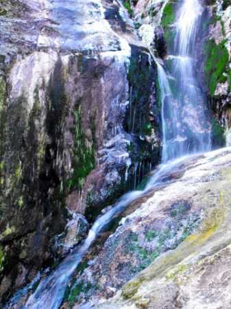
Picture: Waterfall at O
Homerclesse on Maulin
by Homerclesse
15 Feb 2010
Walked this area on Thursday last on a cold but sunny day (I even got a bit of sunburn). I parked in Crone and followed the path to the Stile as described by many contributers previously. I planned to follow the wall up the side of the forest and find the summit that way. This is a very rough route however, so I really would recommend water proof boots and poles. I can only imagine that the Raven's Glen only gets wetter in the Summer months as the ice melts. As a detour I scrambled across the rocks in the Glen to O'Tooles Rocks. The picture shown is one of the many waterfalls in the area. Once the top of the forest is reached it's just a push for the top along the top line of the forest and on to a trail which leads around to the summit. the views were pretty excellent and all the usuals were in view, including Snowdonia in Wales. I will return to this walk and take on the Tonduffs and Djouce another day. This summit is easily followed on Forest tracks to the top of Crone and out to the heather via a forest firebreak. Linkback: mountainviews.ie/summit/327/comment/4402/
Read Less
Read More
Aderon on Maulin
by Aderon
16 Mar 2009
What a brilliant weekend walk. There're Lynam's books, as you know, and this was a nice route. On way the down I passed people of all ages climbing from the WW side (past Powerscourt), but had taken the zig-zag or Raven's Glen side. Some may prefer this over the WW because you get your workout with few people and then have a really beautiful walk down a nice path, finally meeting others along the way.
For that much, the walk description was a little strange for the "junctions." I went straight up from the car park (two sets of paths go through the woods, one after the other, to avoid the road a good bit). At the second junction (path & road), go right to almost immediatley be at a road T-junction. Go left and up, coming soon to another "x" junction. Now this road folds back on itself, goes straight (sort of off road) or down. Go straight and up, in the Raven's Glen direction (this was where it was a bit confusing because the guide says to stay on the road, even though the road proper folds back on itself). Go up and to the next junction to go left, and then immediately right to the climb the zig-zags, across a fence and stile (stop for a good few pics of Raven's Glen) and immediately left back on yourself a bit to contour up to Maulin top (I went straight up once I found the next path and aimed for the stone wall). The wind was fierce enough that when I took a step in the direction of the bluff leading to Tonduff, the wind held me even while leaning at 50 degrees! Ah well, so back down the well marked trail on the WW towards Powerscourt. It really is a very relaxing walk that way. Once in the tree cover, I slid down into the rows of red leaves beside a bluff, turned on the ole jetboil (keeping it out of the leaves of course) and had a well earned soup and tea with a book :D (and nearly a nap!). Linkback: mountainviews.ie/summit/327/comment/3644/
Read Less
Read More
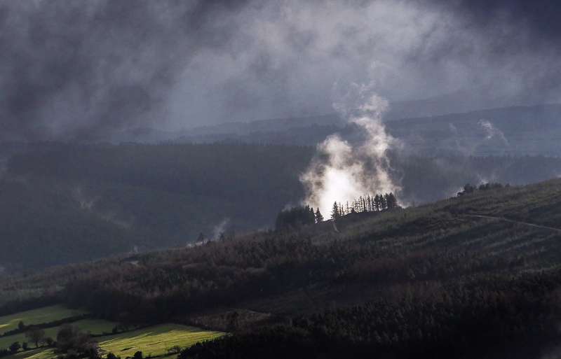
Picture: Maulin from the slopes of Prince William's seat.
Misty morning
by simon3
22 Jan 2019
Just sometimes and just for a short while a damp forest can show a misty fairy side. And so it was one January day after a heavy raincloud had passed and the sun had magicked this sprite into the air. Linkback: mountainviews.ie/summit/327/comment/20343/
Read Less
Read More
csd on Maulin
by csd
2 Mar 2003
A quick afternoon walk: Park in Crone car park on the Powerscourt - Lough Bray road. Follow the
Wicklow Way markers until you come out onto open ground on the shoulders of Maulin, turn right up the hill and head for the summit. Nice views from the top. Then head north until you come to a wall, turn right and handrail the wall till you come to a break in the forest to your left. Follow the break all the way down to the forest track, turn right, and head back to the car park. Should only take 2.5 - 3 hours tops. The picture shows Maulin and Tonduff, taken from the summit of the Great Sugar Loaf. Funnily enough, Maulin looks lower than my vantage point, even though it's 70 metres higher... Linkback: mountainviews.ie/summit/327/comment/359/
Use of MountainViews is governed by conditions and a privacy policy.
Read general information about the site. Opinions in material here are not necessarily endorsed by MountainViews.
Hillwalking is a risk sport. Information in comments, walks, shared GPS tracks or about starting places may
not be accurate for example as regards safety or access permission. You are responsible for your safety and your permission to walk.
See the credits and list definitions.


 Our Facebook page.