Members and Supporters, the MountainViews Committee requests your help to meet the costs of the website and of other activities such as insured events or publications.
Feature count in area: 115, by county: Wicklow: 108, Kildare: 4, Wexford: 2, Carlow: 3, of which 1 is in both Wexford and Wicklow, of which 1 is in both Carlow and Wicklow,
OSI/LPS Maps: 28B, 55, 56, 61, 62, AWW, EW-DM, EW-LG, EW-WE, EW-WS
Highest Place: Lugnaquilla 924.7m
Starting Places (205) in area Wicklow: 1916 Memorial Car Park, Aghavannagh Ow Bridge, Aghowle Wood, Altidore Wood Entrance, Annacurra National School, Annalecka Bridge, Asbawn Brook L8350, Aughrim National School, Ballard Road, Ballinabarny Gap, Ballinagappoge Bridge Layby, Ballinagappoge Mountain Hairpin, Ballinagore, Ballinahinch Wood, Ballinastoe MBT CP, Ballinastraw South, Ballineddan Upr Fork, Ballinfoyle Upr Cross, Ballycoog, Ballycreen Brook Bridge, Ballycumber, Ballycumber Bridge, Ballycumber Lane, Ballycumber Wicklow Way, Ballylerane, Ballylow Bridge, Ballylusk Quarry, Ballymanus Lane, Ballymoyle Shooting Lodge, Ballynultagh Gap, Ballynultagh Lane, Ballyreagh Wood, Ballyross Forest, Ballysmuttan Long Stone, Baravore, Barnbawn South, Barranisky North, Barranisky West, Bohilla Land Roundabout, Bohilla Lane Mid, Boranaraltry Bridge, Bray Harbour, Brewel West, Brittas Bay North CP, Buckroney Sand Dunes CP, Bus Terminus, Camera Hill Track Cross, Castletimon Wood North, Clara Vale, Clone House Road, Clonegal, Cloon Wood Cp, Coate Bridge, Coolballintaggart Ledge, Coolbawn House Lane, Cransillagh Brook , Crone Wood CP, Crossbridge, Crossoona Rath, Cummer Wood South, Curtlestown Wood CP, Deputy's Pass CP, Derralossary Church, Derry River Bridge, Devil's Glen CP, Devil's Glen Wood, Djouce Wood Calary, Djouce Wood Lake, Djouce Wood Long Hill, Donard, Donnelly's Lane Car Sales, Drumgoff Forest, Dunranhill North, Dunranhill SE, Dunranhill South, Dwyer McAllister Cottage CP, Enniskerry, Fentons Pub, Fitzsimons Park GAA, unuseableFlemings Footbridge Glen Rd, Gap Pub, Gap Road, Glen Beach CP, Glen of the Downs CP, Glenbride Lane, Glenbride Lodge, Glencree Reconciliation, Glendalough, Glenealy GAA, Glenmacnass Tonelagee CP, Glenmalure Hostel, Glenmalure Lodge, Glenmalure Waterfall, Glenview Hotel, Gowle House, Great Sugar Loaf CP, Grove Bar, Heffernans Well Wood, Hill View, Hollywood Glen, JB Malone CP, Johnnie Fox Pub, Keadeen NE trail, Keadeen Trailhead, Kevins Way Footbridge, Kilbride Army Camp Entrance, Kilcandra South, Kilcommon View, Killalongford Wood, Kilmacrea Cross Roads, Kilranelagh House Gate, Kilruddery Car Park, Kilruddery Cottages, Kings River, Kippure Bridge, Kippure Estate, Kippure Transmitter Gate, Knickeen Cross, Knocknaboley Lane Leeraghs Bog, Knocknaboley Lane Stone Cottage, Knockrath Little, Knockree west, Kyle Loop North, Lackan Wood S, Lake Dr Fraughan Brook, Lake Drive, Lake Park Cross, Lake View Pub, Laragh Free Car Park, Laragh NSch, Lead Mines CP, Liffey Bridge, Liffey Head Bridge, Lough Bray Lower, Lough Bray Upper, Lough Tay North Viewing Point, Lough Tay Wicklow Way CP, Luglass Lane L97561, Lugnagun Track, Macreddin Village, Mangans Lane, Military Road Carrigshouk Hill, Military Road Inchavore River Nth, Military Road Inchavore River Sth, Military Road NW Lough Tay, Military Road Ballyboy Bridge, Military Road Cloghoge Brook, Military Road Croaghanmoira, Military Road Fananierin, Military Road LaraghWicklow Way, Military Road Slieve Maan, Monspolien Bridge, Moortown House, Mountain Rescue HQ, Muskeagh Little Wood, Nahanagan Lough NE, Novara Avenue, Bray, Oiltiagh Brook Knickeen, Old Bridge Cross, Old Bridge Scouts , Old Wicklow Way entrance, Paddock Hill SE, Pier Gates CP, Powerscourt Waterfall CP, Putland Road, Quintagh East, Raheen Park CP, Raheenleagh East, Railway Walk CP, Rathdrum Railway Station, Rednagh Wood, Rocky Valley, Roundwood, Sally Gap, Sally Gap N, Seefin Trailhead, Seskin SE, Shankill Tributary Bridge, Shay Elliott, Sheepshanks Bridge, Shillelagh, Slievecorragh Track, Slievefoore South, Sraghoe Brook, St John's Church, St Kevins Chair, St Kevins Church, St Kevins Way R756, Stone Circle Bridge, Stookeen South, Stranahely Wood, Stranakelly Cross Roads, Tallyho, Templeboden, Tithewer, Tomcoyle L, Tomriland Wood, Toor Brook, Trooperstown Hill Access, Turlough Hill CP, Upper Lake CP, Vallymount GAA CP, Vartry Reservoir Upper, Zellers Pub
Summits & other features in area Wicklow: Cen: Glendalough North: Brockagh Mountain 556.9m, Brockagh Mountain NW Top 549.5m, Brockagh Mountain SE Top 471.7m, Camaderry East Top 677.3m, Camaderry Mountain 698.6m, Conavalla 734m, Tomaneena 682.4m Cen: Glendalough South: Carriglineen Mountain 456.6m, Cullentragh Mountain 510m, Derrybawn Mountain 476.1m, Kirikee Mountain 474.5m, Lugduff 653.2m, Lugduff SE Top 638m, Mullacor 660.7m, Trooperstown Hill 430m N Cen: Tonelagee: Carrignagunneen 561m, Fair Mountain 571.2m, Stoney Top 713.7m, Tonelagee 815.8m, Tonelagee E Top 668m, Tonelagee South-East Top 545.8m NE: Bray & Kilmacanogue: Bray Head Hill 238.9m, Carrigoona Commons East 242m, Downs Hill 372.9m, Great Sugar Loaf 501.2m, Little Sugar Loaf 342.4m NE: Djouce: Djouce 725.5m, Knockree 342.1m, Maulin 570m, Tonduff 642m, Tonduff East Top 593m, War Hill 684.8m, White Hill 631.1m NE: Fancy: Ballinafunshoge 480m, Kanturk 527.4m, Knocknacloghoge 532.4m, Luggala 593.3m, Robber's Pass Hill 508.9m, Scarr 640m, Scarr North-West Top 559.8m, Sleamaine 430m NE: Vartry: Ballinacorbeg 336m, Ballycurry 301m, Dunranhill 342m, Mount Kennedy 365.9m NW: Blessington: Carrigleitrim 408m, Lugnagun 446.2m, Slieveroe 332m, Sorrel Hill 599.5m NW: Mullaghcleevaun: Black Hill 602.2m, Carrigshouk 572.5m, Carrigvore 682.4m, Duff Hill 720.8m, Gravale 719m, Moanbane 703m, Mullaghcleevaun 846.7m, Mullaghcleevaun East Top 796m, Silsean 698m S: Aughrim Hills: Cushbawn 400m, Killeagh 249m, Moneyteige North 427m, Preban Hill 389m S: Croaghanmoira: Ballinacor Mountain 529.3m, Ballycurragh Hill 536m, Ballyteige 447m, Carrickashane Mountain 508m, Croaghanmoira 662.3m, Croaghanmoira North Top 579.5m, Fananierin 426m, Slieve Maan 547.8m, Slieve Maan North Top 546.1m S: Croghan Kinsella: Annagh Hill 454m, Croghan Kinsella 606m, Croghan Kinsella East Top 562.1m, Slievefoore 414m S: Shillelagh Hills: Lakeen 357m, Monaughrim 206m, Seskin 344m, Stookeen 420m S: Tinahely Hills: Ballycumber Hill 429.7m, Eagle Hill 296m, Muskeagh Hill 398.2m SE: Wicklow South East: Ballinastraw 284m, Ballyguile Hill 188m, Barranisky 280m, Carrick Mountain 381m, Collon Hill 238m, Kilnamanagh Hill 217m, Westaston Hill 270m W: Baltinglass: Ballyhook Hill 288m, Baltinglass Hill 382m, Carrig Mountain 571m, Carrigeen Hill 298m, Cloghnagaune 385m, Corballis Hill 258m, Keadeen Mountain 653m, Spinans Hill 409m, Spinans Hill SE Top 400m, Tinoran Hill 312m W: Cen Lugnaquilla: Ballineddan Mountain 652.3m, Benleagh 689m, Camenabologue 758m, Camenabologue SE Top 663m, Cloghernagh 800m, Corrigasleggaun 794.6m, Lugnaquilla 924.7m, Slievemaan 759.7m W: Donard: Brewel Hill 222m, Church Mountain 544m, Corriebracks 531m, Lobawn 636m, Slievecorragh 418m, Sugarloaf 552m, Table Mountain 701.7m, Table Mountain West Top 563m
Note: this list of places may include island features such as summits, but not
islands as such.
Tonelagee, 815.8mMountain Tóin le Gaoith A name in Irish,
Place Rating ..
(Ir. Tóin le Gaoith [GE], 'backside to the wind') Tonelegee an extra name in English, Wicklow County in Leinster province, in Arderin, Vandeleur-Lynam, Irish Highest Hundred Lists, Tonelagee is the third highest mountain in the Wicklow area and the 34th highest in Ireland. Tonelagee is the third highest point in county Wicklow.
Grid Reference O08502 01591,
OS 1:50k mapsheet 56 Place visited by: 1113members, recently by: rhw, Sophie-Hayes, KateLeckie, MartMc, Courin, MeabhTiernan, knightsonhikes, Paddym99, garybuz, Deirdreb, taramatthews, orlaithfitz, maoris, davidrenshaw, Lidia27
I visited this place: NO (You need to be a logged-in member for this.)
Longitude: -6.3826, Latitude: 53.054259, Easting: 308503, Northing: 201592,
Prominence: 202m, Isolation: 1.1km, Has trig pillar
ITM: 708428 701625 Bedrock type: Adamellite with microcline phenocrysts, (Glendalough Adamellite) Notes on name: Tandragee (Tóin re Gaoith), the town in Co. Armagh, has the same meaning, as do several other places in Ireland, but it is difficult to know what they have in common.
Short or GPS IDs, 6 char: Tnlg, 10 char: Tonelagee Linkback: https://mountainviews.ie/summit/33/
Gallery for Tonelagee (Tóin le Gaoith) and surrounds
Summary
for Tonelagee (Tóin le Gaoith):
Airy scenic vantage point with many routes.
Summary created by markmjcampion, simon3
2023-08-18 16:06:25
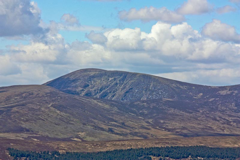
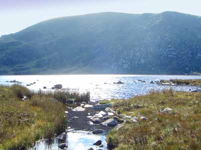
Picture: Tonelagee from the NE
This summit has much to recommend it, being high & cliffy, having the heart-shaped Lough Ouler below it and being part of the fine ridge from Mullaghcleevaun to Laragh. It overlooks much of the heart of Wicklow.
SW. Park at the Wicklow Gap TurL Hl (O0752 0017) and from there it's a quick and simple though stern climb of about 350m. The track starts slightly to the right as you cross the road. Allow 45 min.
NW. From the Glenmacnass Car Park at around GlMacnas (O11402 02991), the route crosses the Glenmacnass River [prone to fast flooding] and goes via the NE top, a minor ridge. Allow 1hr+
N. It can also be tackled from Mullaghcleevaun via the notoriously boggy Barnacullian ridge and Stoney Top. If coming this way keep to the E of the ridge to avoid the worst of the bog.
SE. A sharp, steep ascent from the boggy area to the NW of the Brockaghs will also get you there. There is a not-very-obvious track which is worth looking for as you approach the steep ground. It's a continuation of the feint track from the Brockaghs so it shouldn't be too hard to find. Approx GR is A (O09247 00822)
SE. You can also summit via Mall Hill which itself can be accessed from a long forest track starting in Laragh. Leave the forest at approx B (O11382 00371) and go slightly uphill to Mall Hill where there are some magnificent erratics to shelter behind if the need arises.
Notable tracks include track/2372, track/3809 and for the long distance trekkers among you track/3395 may well whet your appetite!
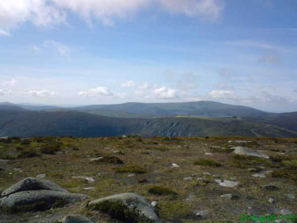
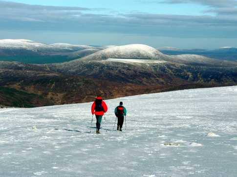
Picture: View from summit looking across the Reservoir with Lugnaquillia Mountain in the backround
pplsgod on Tonelagee
by pplsgod
23 Aug 2009
Climbed this mountain on the 22nd August 2009. Weather conditions were absolutely perfect on the day. From OS Map No. 56 I parked at location Lead (T099 982) (the car park at the disused lead works overlooking the Vale of Glendasan) From here I took a northern route direct upto Brockagh mountain, this is the best route to avoid the thickest of the Gorse and Heather. Approx half way up take a north east bearing to reach the top of Brockagh. I have climbed this mountain twice and find it the best route. From the summit of Brockagh it is possible to hike across to Tonelagee. From OS Map No. 56 there are three summits (unnamed) shown between the two mountains, I used these as my way markers across to Tonelagee. These appear to be the best routes across as it is quite marshy and boggy, try to avoid the low-lying ground as it is quite easy to get stuck. Also beware of some holes in the ground leading to underground springs. They are difficult to see until nearly too late but due care and attention is enough to keep you safe. From the nearest summit to Tonelagee located to the south east, gently start making your way north east, avoiding the valley and springs that block your way (this will make sense when you see them in front of you) I proceeded to C (O093 018) (approx halfway between Tonelagee NE Top and Tonelagee itself) this route appears to be one of the easiest to climb from this side of the mountain with the added benefit of a great view of Lough Ouler. The last third is a tiring climb but relatively straight forward as the sheep and mountain goats have marked a route in the boggy ground.
I descended taking a south west route from the summit, basically heading for the wicklow gap car park from the summit. This route is very overgrown with heather particularly as you get nearer the base so a little care is advisable. It is doable but the ground can be undulating. Once I got to the Wicklow gap car park I took the main road walk back to where I parked. Began this hike at 9am and was back in the car by 1.30pm. Perfect weather conditions. Linkback: mountainviews.ie/summit/33/comment/4032/
Read Less
Read More
GWPR on Tonelagee
by GWPR
30 Jul 2003
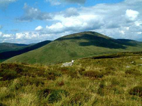
Summer cloud shadows drift over Tonelagee as viewed from Turlough Hill with the usual Wicklow 'spectator'! Linkback: mountainviews.ie/summit/33/comment/588/
Read Less
Read More
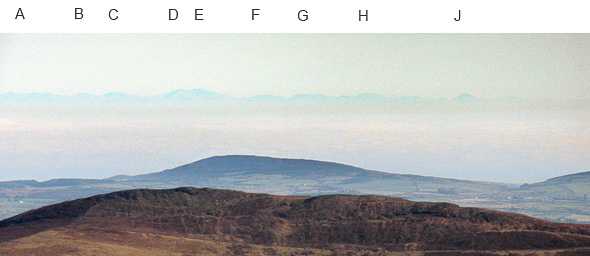
Picture: Wales from Tonelagee
Long views from the summit.
by simon3
1 Mar 2011
On a clear day look east from Tonelagee and you may be rewarded with rather more summits than you might expect.
The nearer summit is Scarr, the hazy summits on the skyline are in Wales.
After some very helpful contributions on newsgroup uk.rec.walking (thanks Paul Saunders et al) the best estimate is that the summit at D is Crib y Ddysgl (aka Garnedd Ugain 1065m), which would make Summit E just to the right, Snowdon (1085m and 155km away). Between E and J is the Nantlle ridge. The summit at J may be Yr Eifl. Linkback: mountainviews.ie/summit/33/comment/2604/
Read Less
Read More
simon3 on Tonelagee
by simon3
14 Oct 2002
In 1895 H.C.Hart said of Tonelagee ".. a round mass of moorland, has on the northern shoulder a crater-like valley, containing a tarn, Lough Ouler, and cliffs of schistose, some 400 to 500 ft. high, descending from the near the summit to the margins of the lake." This picture shows Lough Ouler where it feeds into Lough Brook on a bright day in Sept 2002. Linkback: mountainviews.ie/summit/33/comment/156/
Read Less
Read More
shippy on Tonelagee
by shippy
24 Jan 2005
Tonelagee in the centre with Mullaghcleevaun to the left , pic taken from Lugnaquillia in january 05 .The flat section beneath Tonelagee is a resevior on Turlough Hill almost 700m high. The E.S.B built it in the 70,s.
Water is pumped down hill at night to turbines creating electricity.Climbed Tonelagee, with friends, in July 04, from the car park at the Wicklow Gap, which is between Turlough Hill and Tonelagee.Lovely views from the top of Lough Ouler and surrounding mnts.Went from there to Stoney Top and on to Mullaghcleevaun ,then to Mullaghcleevaun East Top .There's a large upright stone with a cross etched on it on Stoney Top, could have something to do with St. Kevin.We went from east top down through the valley and made our way to Lough Ouler.There i found and held a common lizard , the only type of lizard native to Ireland .Same size as a newt , but with a snake like head and forked tongue , not very common.We climbed Tonelagee from the lake and made our way back to the car park. It was a clear day with good visibility, the walk was about 11 miles and took us 7 hours .Well worth doing on a good day. Linkback: mountainviews.ie/summit/33/comment/1438/
Use of MountainViews is governed by conditions and a privacy policy.
Read general information about the site. Opinions in material here are not necessarily endorsed by MountainViews.
Hillwalking is a risk sport. Information in comments, walks, shared GPS tracks or about starting places may
not be accurate for example as regards safety or access permission. You are responsible for your safety and your permission to walk.
See the credits and list definitions.


 Our Facebook page.