Members and Supporters, the MountainViews Committee requests your help to meet the costs of the website and of other activities such as insured events or publications.
Feature count in area: 115, by county: Wicklow: 108, Kildare: 4, Wexford: 2, Carlow: 3, of which 1 is in both Wexford and Wicklow, of which 1 is in both Carlow and Wicklow,
OSI/LPS Maps: 28B, 55, 56, 61, 62, AWW, EW-DM, EW-LG, EW-WE, EW-WS
Highest Place: Lugnaquilla 924.7m
Starting Places (205) in area Wicklow: 1916 Memorial Car Park, Aghavannagh Ow Bridge, Aghowle Wood, Altidore Wood Entrance, Annacurra National School, Annalecka Bridge, Asbawn Brook L8350, Aughrim National School, Ballard Road, Ballinabarny Gap, Ballinagappoge Bridge Layby, Ballinagappoge Mountain Hairpin, Ballinagore, Ballinahinch Wood, Ballinastoe MBT CP, Ballinastraw South, Ballineddan Upr Fork, Ballinfoyle Upr Cross, Ballycoog, Ballycreen Brook Bridge, Ballycumber, Ballycumber Bridge, Ballycumber Lane, Ballycumber Wicklow Way, Ballylerane, Ballylow Bridge, Ballylusk Quarry, Ballymanus Lane, Ballymoyle Shooting Lodge, Ballynultagh Gap, Ballynultagh Lane, Ballyreagh Wood, Ballyross Forest, Ballysmuttan Long Stone, Baravore, Barnbawn South, Barranisky North, Barranisky West, Bohilla Land Roundabout, Bohilla Lane Mid, Boranaraltry Bridge, Bray Harbour, Brewel West, Brittas Bay North CP, Buckroney Sand Dunes CP, Bus Terminus, Camera Hill Track Cross, Castletimon Wood North, Clara Vale, Clone House Road, Clonegal, Cloon Wood Cp, Coate Bridge, Coolballintaggart Ledge, Coolbawn House Lane, Cransillagh Brook , Crone Wood CP, Crossbridge, Crossoona Rath, Cummer Wood South, Curtlestown Wood CP, Deputy's Pass CP, Derralossary Church, Derry River Bridge, Devil's Glen CP, Devil's Glen Wood, Djouce Wood Calary, Djouce Wood Lake, Djouce Wood Long Hill, Donard, Donnelly's Lane Car Sales, Drumgoff Forest, Dunranhill North, Dunranhill SE, Dunranhill South, Dwyer McAllister Cottage CP, Enniskerry, Fentons Pub, Fitzsimons Park GAA, unuseableFlemings Footbridge Glen Rd, Gap Pub, Gap Road, Glen Beach CP, Glen of the Downs CP, Glenbride Lane, Glenbride Lodge, Glencree Reconciliation, Glendalough, Glenealy GAA, Glenmacnass Tonelagee CP, Glenmalure Hostel, Glenmalure Lodge, Glenmalure Waterfall, Glenview Hotel, Gowle House, Great Sugar Loaf CP, Grove Bar, Heffernans Well Wood, Hill View, Hollywood Glen, JB Malone CP, Johnnie Fox Pub, Keadeen NE trail, Keadeen Trailhead, Kevins Way Footbridge, Kilbride Army Camp Entrance, Kilcandra South, Kilcommon View, Killalongford Wood, Kilmacrea Cross Roads, Kilranelagh House Gate, Kilruddery Car Park, Kilruddery Cottages, Kings River, Kippure Bridge, Kippure Estate, Kippure Transmitter Gate, Knickeen Cross, Knocknaboley Lane Leeraghs Bog, Knocknaboley Lane Stone Cottage, Knockrath Little, Knockree west, Kyle Loop North, Lackan Wood S, Lake Dr Fraughan Brook, Lake Drive, Lake Park Cross, Lake View Pub, Laragh Free Car Park, Laragh NSch, Lead Mines CP, Liffey Bridge, Liffey Head Bridge, Lough Bray Lower, Lough Bray Upper, Lough Tay North Viewing Point, Lough Tay Wicklow Way CP, Luglass Lane L97561, Lugnagun Track, Macreddin Village, Mangans Lane, Military Road Carrigshouk Hill, Military Road Inchavore River Nth, Military Road Inchavore River Sth, Military Road NW Lough Tay, Military Road Ballyboy Bridge, Military Road Cloghoge Brook, Military Road Croaghanmoira, Military Road Fananierin, Military Road LaraghWicklow Way, Military Road Slieve Maan, Monspolien Bridge, Moortown House, Mountain Rescue HQ, Muskeagh Little Wood, Nahanagan Lough NE, Novara Avenue, Bray, Oiltiagh Brook Knickeen, Old Bridge Cross, Old Bridge Scouts , Old Wicklow Way entrance, Paddock Hill SE, Pier Gates CP, Powerscourt Waterfall CP, Putland Road, Quintagh East, Raheen Park CP, Raheenleagh East, Railway Walk CP, Rathdrum Railway Station, Rednagh Wood, Rocky Valley, Roundwood, Sally Gap, Sally Gap N, Seefin Trailhead, Seskin SE, Shankill Tributary Bridge, Shay Elliott, Sheepshanks Bridge, Shillelagh, Slievecorragh Track, Slievefoore South, Sraghoe Brook, St John's Church, St Kevins Chair, St Kevins Church, St Kevins Way R756, Stone Circle Bridge, Stookeen South, Stranahely Wood, Stranakelly Cross Roads, Tallyho, Templeboden, Tithewer, Tomcoyle L, Tomriland Wood, Toor Brook, Trooperstown Hill Access, Turlough Hill CP, Upper Lake CP, Vallymount GAA CP, Vartry Reservoir Upper, Zellers Pub
Summits & other features in area Wicklow: Cen: Glendalough North: Brockagh Mountain 556.9m, Brockagh Mountain NW Top 549.5m, Brockagh Mountain SE Top 471.7m, Camaderry East Top 677.3m, Camaderry Mountain 698.6m, Conavalla 734m, Tomaneena 682.4m Cen: Glendalough South: Carriglineen Mountain 456.6m, Cullentragh Mountain 510m, Derrybawn Mountain 476.1m, Kirikee Mountain 474.5m, Lugduff 653.2m, Lugduff SE Top 638m, Mullacor 660.7m, Trooperstown Hill 430m N Cen: Tonelagee: Carrignagunneen 561m, Fair Mountain 571.2m, Stoney Top 713.7m, Tonelagee 815.8m, Tonelagee E Top 668m, Tonelagee South-East Top 545.8m NE: Bray & Kilmacanogue: Bray Head Hill 238.9m, Carrigoona Commons East 242m, Downs Hill 372.9m, Great Sugar Loaf 501.2m, Little Sugar Loaf 342.4m NE: Djouce: Djouce 725.5m, Knockree 342.1m, Maulin 570m, Tonduff 642m, Tonduff East Top 593m, War Hill 684.8m, White Hill 631.1m NE: Fancy: Ballinafunshoge 480m, Kanturk 527.4m, Knocknacloghoge 532.4m, Luggala 593.3m, Robber's Pass Hill 508.9m, Scarr 640m, Scarr North-West Top 559.8m, Sleamaine 430m NE: Vartry: Ballinacorbeg 336m, Ballycurry 301m, Dunranhill 342m, Mount Kennedy 365.9m NW: Blessington: Carrigleitrim 408m, Lugnagun 446.2m, Slieveroe 332m, Sorrel Hill 599.5m NW: Mullaghcleevaun: Black Hill 602.2m, Carrigshouk 572.5m, Carrigvore 682.4m, Duff Hill 720.8m, Gravale 719m, Moanbane 703m, Mullaghcleevaun 846.7m, Mullaghcleevaun East Top 796m, Silsean 698m S: Aughrim Hills: Cushbawn 400m, Killeagh 249m, Moneyteige North 427m, Preban Hill 389m S: Croaghanmoira: Ballinacor Mountain 529.3m, Ballycurragh Hill 536m, Ballyteige 447m, Carrickashane Mountain 508m, Croaghanmoira 662.3m, Croaghanmoira North Top 579.5m, Fananierin 426m, Slieve Maan 547.8m, Slieve Maan North Top 546.1m S: Croghan Kinsella: Annagh Hill 454m, Croghan Kinsella 606m, Croghan Kinsella East Top 562.1m, Slievefoore 414m S: Shillelagh Hills: Lakeen 357m, Monaughrim 206m, Seskin 344m, Stookeen 420m S: Tinahely Hills: Ballycumber Hill 429.7m, Eagle Hill 296m, Muskeagh Hill 398.2m SE: Wicklow South East: Ballinastraw 284m, Ballyguile Hill 188m, Barranisky 280m, Carrick Mountain 381m, Collon Hill 238m, Kilnamanagh Hill 217m, Westaston Hill 270m W: Baltinglass: Ballyhook Hill 288m, Baltinglass Hill 382m, Carrig Mountain 571m, Carrigeen Hill 298m, Cloghnagaune 385m, Corballis Hill 258m, Keadeen Mountain 653m, Spinans Hill 409m, Spinans Hill SE Top 400m, Tinoran Hill 312m W: Cen Lugnaquilla: Ballineddan Mountain 652.3m, Benleagh 689m, Camenabologue 758m, Camenabologue SE Top 663m, Cloghernagh 800m, Corrigasleggaun 794.6m, Lugnaquilla 924.7m, Slievemaan 759.7m W: Donard: Brewel Hill 222m, Church Mountain 544m, Corriebracks 531m, Lobawn 636m, Slievecorragh 418m, Sugarloaf 552m, Table Mountain 701.7m, Table Mountain West Top 563m
Note: this list of places may include island features such as summits, but not
islands as such.
Silsean, 698mMountain Soillsean A name in Irish,
Place Rating ..
(Ir. Soillsean [PNCW], 'place of lights'), Oghill, Wicklow County in Leinster province, in Arderin, Vandeleur-Lynam Lists, Silsean is the 117th highest place in Ireland.
Grid Reference O02318 05649,
OS 1:50k mapsheet 56 Place visited by: 447members, recently by: rhw, knightsonhikes, orlaithfitz, maoris, davidrenshaw, Prem, Carolineswalsh, Nailer1967, Sarahjb, Moirabourke, Arcticaurora, ToughSoles, muddypaws, SeanPurcell, Kaszmirek78
I visited this place: NO (You need to be a logged-in member for this.)
Longitude: -6.47351, Latitude: 53.091921, Easting: 302318, Northing: 205649,
Prominence: 43m, Isolation: 1.6km ITM: 702244 705681 Bedrock type: Pale grey fine to coarse-grained granite, (Type 2e equigranular)
Short or GPS IDs, 6 char: Slsn, 10 char: Silsean Linkback: https://mountainviews.ie/summit/113/
Gallery for Silsean (Soillsean) and surrounds
Summary
for Silsean (Soillsean):
One Part of a Double Act
Summary created by simon3, wicklore
2023-04-07 09:50:47
Picture: Silsean from Moanbane
Silsean is rarely mentioned or climbed without reference to its almost twin summit Moanbane. The two tops are the highest points of the area of mountain overlooking the hamlet of Ballyknockan to the east of the Blessington Lakes and Phoulaphuca Reservoir. There is about 1.5kms between the tops, and Silsean is the smaller by 5 metres. However Silsean has a summit cairn, while Moanbane makes do with a summit pond. The cairn on Silsean has recently been rebuilt by volunteers into a 3.5 foot high beehive from stone on the hill. The same volunteers have attempted to repair damage caused by quad bikes by transplanting sods of bog to the scarred summit area.
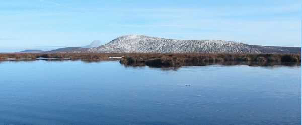
Silsean can be reached directly either from Lake Drive (O00415 06643) or B'Knock Bus (O01141 07290). For a much longer walk start at the Black Hill car park at BNulta Gp (O04387 10862). Silsean offers great views across the Blessington Lakes, as well as south to Slievecorragh, Church Mountain, and Corriebracks.
Silsean also offers fantastic opportunities for lengthy snow sliding on its western slopes in the winter!
What could be more Irish for St Patricks day than a ramble in our green hills!! I followed csds advice and approached Silsean from the Garryknock side. There is a forest track indicated on sheet 56 at A (O031 036) and this is where I parked up. There is the standard coillte yellow and black forest gate across this track and while the whole area looks less than frequently used, in the short space of time it took me to pull on my boots and pack the bag no less than two local farmers approached the gate, unlocked it, and entered the forest area to herd and feed sheep. There is really only room for perhaps two cars at this location and due care should be given not to block the gate. In hindsight there are also plenty of parking opportunities further along this road, in particular around the houses at the end of the road.
So off I set along the forest track through the trees. I stuck with this track until it petered out as indicated on sheet 56. As you come to the end of the track there is a large turning circle and from here the track narrows and continues for perhaps another 50m. At this point a fence appears on your right hand side and inside it there is a faint track. While it does look fairly inhospitable just stick with it as it gradually opens up and is easy to walk along (fence should be with you on your right hand side the whole way). In no time at all you will be led onto open mountian and from here its a short forward skip to the summit.
My dated version of sheet 56 indicated forestry to the summit of Silsean which is certainly not the case. The photos of csd and simon3 show a timber post which indicates the summit of Silsean. As you can see from the photo below someone has taken the time to build a somewhat decorative cairn around this timber post - from a distance it looks just like a wishing well! Car to summit could be comfortably completed in 50mins. Refer to Moanbane for rest of route. Linkback: mountainviews.ie/summit/113/comment/4517/
Read Less
Read More
Ochill is the name for this summit area!
by Barry
10 Aug 2016
Silsean is not the appropriate name for the SW end of Moanvayn or Moanbane hill. This name never appeared on any Ordnance Survey map till the early 1990s when OSi were seeking feedback from users of their new 1:50,000 Discovery maps. There seems to have been a knowledge that Liam Price identified this as a local name and listed it as 'Shileshawn' in his Placenames of County Wicklow (1950s), where he clearly says it applies to the NORTHERN side of the hill and the Ballynastockan Brook area in particular. I verified this with local people again in recent years who know this name for the area often called the Shiney Flags on the northern flanks of the hill. The hill as a whole is known locally as Moanvayn and the SW end is called Ochill or Oghill, said like Oakhill. However hillwalkers seem to have considered that the NE summit is Moanbane as per OS and therefore erroneously concluded that by default, that Silsean should the other more SW summit, then fed this information to OSi, who are promulgating it on their maps. I have been contacted many times by people telling me that EastWest Mapping maps are wrong, because Silsean is marked differently on OSi maps - so please take note. Silsean is not the correct local name for this top and the fact that it appears on an OSi publication does not make it gospel!! :) Please excuse my frustration as it arises often! Linkback: mountainviews.ie/summit/113/comment/18612/
Read Less
Read More
csd on Silsean
by csd
27 Oct 2003
There were still patches of snow on Mullaghcleevaun from the storms earlier this week. This picture shows the view over to Mullaghcleevaun from the small pond northeast of the summit of Silsean. Linkback: mountainviews.ie/summit/113/comment/726/
Read Less
Read More
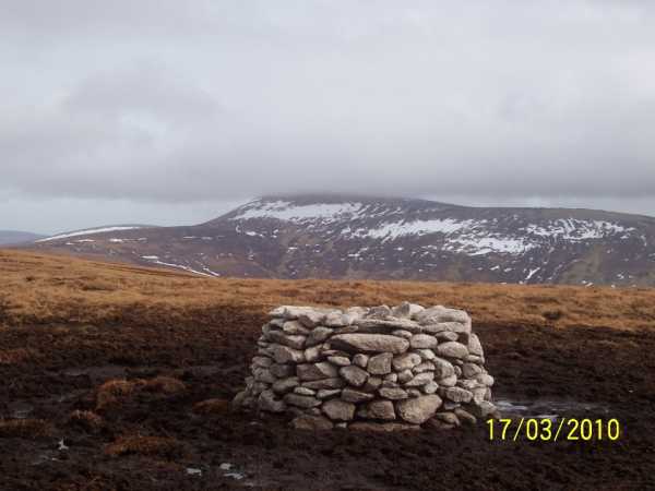
Cairn and other repairs.
by joemalone
5 Apr 2010
Just a quick note reference Darrenf's mention of the new Cairn on top of Silsean.
Myself and some friends who live in Ballyknockan often walk in the general area of Silsean, Moanbane and Mullacleevaun. We were getting frustrated with the state of the summit of Silsean which had almost totally turned to a wet boggy mess because of the motorbikes and quad bikes which on an almost weekly basis would joyride all over this area.
We started to build the Cairn using stone from about 100 to 150 metres away in a northerly direction. We carried a lot of the stone by hand but also used a stretcher.
As well as building the cairn we also moved a lot of sods from lower on the hill to the summit in order to get some of the grass and other plants to take root and hopefully displace some of the water and make the ground "walkable" again.
We hope to finish the cairn his summer. We intend on making a beehive shape so it should be at least a meter higher and should be seen from further away.
Thankfully it seems that the biking has stopped since the signs went up for National Park at the forest gates above Ballyknockan.
If anyone has the energy or inclination they could always bring a small stone up the hill on their next walk! Linkback: mountainviews.ie/summit/113/comment/4592/
Read Less
Read More
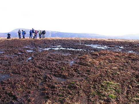
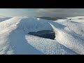
Picture: Silsean wrecked by bikers.
simon3 on Silsean
by simon3
5 Mar 2008
This is the sad summit of Silsean as it is in March 2008. Compare this picture to that of csd's just four and a half years ago. The bikers have churned up the soil destroying the vegetation over the area beside the post you can see in both picures.
Use of MountainViews is governed by conditions and a privacy policy.
Read general information about the site. Opinions in material here are not necessarily endorsed by MountainViews.
Hillwalking is a risk sport. Information in comments, walks, shared GPS tracks or about starting places may
not be accurate for example as regards safety or access permission. You are responsible for your safety and your permission to walk.
See the credits and list definitions.


 Our Facebook page.