Members and Supporters, the MountainViews Committee requests your help to meet the costs of the website and of other activities such as insured events or publications.
Feature count in area: 115, by county: Wicklow: 108, Kildare: 4, Wexford: 2, Carlow: 3, of which 1 is in both Wexford and Wicklow, of which 1 is in both Carlow and Wicklow,
OSI/LPS Maps: 28B, 55, 56, 61, 62, AWW, EW-DM, EW-LG, EW-WE, EW-WS
Highest Place: Lugnaquilla 924.7m
Starting Places (205) in area Wicklow: 1916 Memorial Car Park, Aghavannagh Ow Bridge, Aghowle Wood, Altidore Wood Entrance, Annacurra National School, Annalecka Bridge, Asbawn Brook L8350, Aughrim National School, Ballard Road, Ballinabarny Gap, Ballinagappoge Bridge Layby, Ballinagappoge Mountain Hairpin, Ballinagore, Ballinahinch Wood, Ballinastoe MBT CP, Ballinastraw South, Ballineddan Upr Fork, Ballinfoyle Upr Cross, Ballycoog, Ballycreen Brook Bridge, Ballycumber, Ballycumber Bridge, Ballycumber Lane, Ballycumber Wicklow Way, Ballylerane, Ballylow Bridge, Ballylusk Quarry, Ballymanus Lane, Ballymoyle Shooting Lodge, Ballynultagh Gap, Ballynultagh Lane, Ballyreagh Wood, Ballyross Forest, Ballysmuttan Long Stone, Baravore, Barnbawn South, Barranisky North, Barranisky West, Bohilla Land Roundabout, Bohilla Lane Mid, Boranaraltry Bridge, Bray Harbour, Brewel West, Brittas Bay North CP, Buckroney Sand Dunes CP, Bus Terminus, Camera Hill Track Cross, Castletimon Wood North, Clara Vale, Clone House Road, Clonegal, Cloon Wood Cp, Coate Bridge, Coolballintaggart Ledge, Coolbawn House Lane, Cransillagh Brook , Crone Wood CP, Crossbridge, Crossoona Rath, Cummer Wood South, Curtlestown Wood CP, Deputy's Pass CP, Derralossary Church, Derry River Bridge, Devil's Glen CP, Devil's Glen Wood, Djouce Wood Calary, Djouce Wood Lake, Djouce Wood Long Hill, Donard, Donnelly's Lane Car Sales, Drumgoff Forest, Dunranhill North, Dunranhill SE, Dunranhill South, Dwyer McAllister Cottage CP, Enniskerry, Fentons Pub, Fitzsimons Park GAA, unuseableFlemings Footbridge Glen Rd, Gap Pub, Gap Road, Glen Beach CP, Glen of the Downs CP, Glenbride Lane, Glenbride Lodge, Glencree Reconciliation, Glendalough, Glenealy GAA, Glenmacnass Tonelagee CP, Glenmalure Hostel, Glenmalure Lodge, Glenmalure Waterfall, Glenview Hotel, Gowle House, Great Sugar Loaf CP, Grove Bar, Heffernans Well Wood, Hill View, Hollywood Glen, JB Malone CP, Johnnie Fox Pub, Keadeen NE trail, Keadeen Trailhead, Kevins Way Footbridge, Kilbride Army Camp Entrance, Kilcandra South, Kilcommon View, Killalongford Wood, Kilmacrea Cross Roads, Kilranelagh House Gate, Kilruddery Car Park, Kilruddery Cottages, Kings River, Kippure Bridge, Kippure Estate, Kippure Transmitter Gate, Knickeen Cross, Knocknaboley Lane Leeraghs Bog, Knocknaboley Lane Stone Cottage, Knockrath Little, Knockree west, Kyle Loop North, Lackan Wood S, Lake Dr Fraughan Brook, Lake Drive, Lake Park Cross, Lake View Pub, Laragh Free Car Park, Laragh NSch, Lead Mines CP, Liffey Bridge, Liffey Head Bridge, Lough Bray Lower, Lough Bray Upper, Lough Tay North Viewing Point, Lough Tay Wicklow Way CP, Luglass Lane L97561, Lugnagun Track, Macreddin Village, Mangans Lane, Military Road Carrigshouk Hill, Military Road Inchavore River Nth, Military Road Inchavore River Sth, Military Road NW Lough Tay, Military Road Ballyboy Bridge, Military Road Cloghoge Brook, Military Road Croaghanmoira, Military Road Fananierin, Military Road LaraghWicklow Way, Military Road Slieve Maan, Monspolien Bridge, Moortown House, Mountain Rescue HQ, Muskeagh Little Wood, Nahanagan Lough NE, Novara Avenue, Bray, Oiltiagh Brook Knickeen, Old Bridge Cross, Old Bridge Scouts , Old Wicklow Way entrance, Paddock Hill SE, Pier Gates CP, Powerscourt Waterfall CP, Putland Road, Quintagh East, Raheen Park CP, Raheenleagh East, Railway Walk CP, Rathdrum Railway Station, Rednagh Wood, Rocky Valley, Roundwood, Sally Gap, Sally Gap N, Seefin Trailhead, Seskin SE, Shankill Tributary Bridge, Shay Elliott, Sheepshanks Bridge, Shillelagh, Slievecorragh Track, Slievefoore South, Sraghoe Brook, St John's Church, St Kevins Chair, St Kevins Church, St Kevins Way R756, Stone Circle Bridge, Stookeen South, Stranahely Wood, Stranakelly Cross Roads, Tallyho, Templeboden, Tithewer, Tomcoyle L, Tomriland Wood, Toor Brook, Trooperstown Hill Access, Turlough Hill CP, Upper Lake CP, Vallymount GAA CP, Vartry Reservoir Upper, Zellers Pub
Summits & other features in area Wicklow: Cen: Glendalough North: Brockagh Mountain 556.9m, Brockagh Mountain NW Top 549.5m, Brockagh Mountain SE Top 471.7m, Camaderry East Top 677.3m, Camaderry Mountain 698.6m, Conavalla 734m, Tomaneena 682.4m Cen: Glendalough South: Carriglineen Mountain 456.6m, Cullentragh Mountain 510m, Derrybawn Mountain 476.1m, Kirikee Mountain 474.5m, Lugduff 653.2m, Lugduff SE Top 638m, Mullacor 660.7m, Trooperstown Hill 430m N Cen: Tonelagee: Carrignagunneen 561m, Fair Mountain 571.2m, Stoney Top 713.7m, Tonelagee 815.8m, Tonelagee E Top 668m, Tonelagee South-East Top 545.8m NE: Bray & Kilmacanogue: Bray Head Hill 238.9m, Carrigoona Commons East 242m, Downs Hill 372.9m, Great Sugar Loaf 501.2m, Little Sugar Loaf 342.4m NE: Djouce: Djouce 725.5m, Knockree 342.1m, Maulin 570m, Tonduff 642m, Tonduff East Top 593m, War Hill 684.8m, White Hill 631.1m NE: Fancy: Ballinafunshoge 480m, Kanturk 527.4m, Knocknacloghoge 532.4m, Luggala 593.3m, Robber's Pass Hill 508.9m, Scarr 640m, Scarr North-West Top 559.8m, Sleamaine 430m NE: Vartry: Ballinacorbeg 336m, Ballycurry 301m, Dunranhill 342m, Mount Kennedy 365.9m NW: Blessington: Carrigleitrim 408m, Lugnagun 446.2m, Slieveroe 332m, Sorrel Hill 599.5m NW: Mullaghcleevaun: Black Hill 602.2m, Carrigshouk 572.5m, Carrigvore 682.4m, Duff Hill 720.8m, Gravale 719m, Moanbane 703m, Mullaghcleevaun 846.7m, Mullaghcleevaun East Top 796m, Silsean 698m S: Aughrim Hills: Cushbawn 400m, Killeagh 249m, Moneyteige North 427m, Preban Hill 389m S: Croaghanmoira: Ballinacor Mountain 529.3m, Ballycurragh Hill 536m, Ballyteige 447m, Carrickashane Mountain 508m, Croaghanmoira 662.3m, Croaghanmoira North Top 579.5m, Fananierin 426m, Slieve Maan 547.8m, Slieve Maan North Top 546.1m S: Croghan Kinsella: Annagh Hill 454m, Croghan Kinsella 606m, Croghan Kinsella East Top 562.1m, Slievefoore 414m S: Shillelagh Hills: Lakeen 357m, Monaughrim 206m, Seskin 344m, Stookeen 420m S: Tinahely Hills: Ballycumber Hill 429.7m, Eagle Hill 296m, Muskeagh Hill 398.2m SE: Wicklow South East: Ballinastraw 284m, Ballyguile Hill 188m, Barranisky 280m, Carrick Mountain 381m, Collon Hill 238m, Kilnamanagh Hill 217m, Westaston Hill 270m W: Baltinglass: Ballyhook Hill 288m, Baltinglass Hill 382m, Carrig Mountain 571m, Carrigeen Hill 298m, Cloghnagaune 385m, Corballis Hill 258m, Keadeen Mountain 653m, Spinans Hill 409m, Spinans Hill SE Top 400m, Tinoran Hill 312m W: Cen Lugnaquilla: Ballineddan Mountain 652.3m, Benleagh 689m, Camenabologue 758m, Camenabologue SE Top 663m, Cloghernagh 800m, Corrigasleggaun 794.6m, Lugnaquilla 924.7m, Slievemaan 759.7m W: Donard: Brewel Hill 222m, Church Mountain 544m, Corriebracks 531m, Lobawn 636m, Slievecorragh 418m, Sugarloaf 552m, Table Mountain 701.7m, Table Mountain West Top 563m
Note: this list of places may include island features such as summits, but not
islands as such.
Slievemaan, 759.7mMountain Sliabh Meáin A name in Irish,
Place Rating ..
(Ir. Sliabh Meáin [OSI], 'middle mountain'), Wicklow County in Leinster province, in Arderin, Vandeleur-Lynam Lists, Slievemaan is the 71st highest place in Ireland.
Grid Reference T01758 90819,
OS 1:50k mapsheet 56 Place visited by: 473members, recently by: rhw, MeabhTiernan, davidrenshaw, Magic, Prem, konrad, SeanPurcell, ToughSoles, muddypaws, just.explores, mh400nt, Kaszmirek78, Krzysztof_K, bagoff, noelcurt
I visited this place: NO (You need to be a logged-in member for this.)
Longitude: -6.486529, Latitude: 52.958824, Easting: 301758, Northing: 190819,
Prominence: 54m, Isolation: 1.5km ITM: 701685 690855 Bedrock type: Dark slate-schist, quartzite & coticule, (Butter Mountain Formation) Notes on name: There are two peaks in South Wicklow of this name, though the other, near Croaghanmoira, is written in English as two words.
Short or GPS IDs, 6 char: Slvmn, 10 char: Slievemaan Linkback: https://mountainviews.ie/summit/70/
Gallery for Slievemaan (Sliabh Meáin) and surrounds
Summary
for Slievemaan (Sliabh Meáin):
can be part of a nice circuit.
Summary created by wicklore
2013-04-03 15:55:55
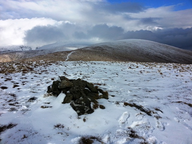
Picture: Slievemaan from Ballineddin Mountain
Slievemaan is doubly disadvantaged. Firstly it is overshadowed (literally) by the highest summit in Leinster, Lugnaquillia, which gains the majority of attention from hillwalkers to these parts. Secondly Slievemaan is just not that exciting a summit. It is boggy, has no dramatic geology and is really just a stop on the way elsewhere. On the redeeming side, it is the 70th highest summit in Ireland, has fine views of nearby Lugnaquillia and it forms part of a fine circuit taking in Lugnaquillia, Slievemaan and Ballineddin Mountains.
One option is to complete a circuit of the Slaney River valley. Start Fentons (S97310 93557) (Fentons Pub) and head along the road to join a trail at CamHill X (S98438 92935). From here follow the trail over Camarahill towards the summit of Lugnaquillia. At S01A (S962 915) 60 either contour around south to the col between Lugnaquillia and Slievemaan at B (T02217 91190), or continue up to Lugnaquillia and then come back down to the col. It’s an easy pull up to Slievemaan, although the col will be terribly wet and boggy on all but the most frozen of days. Enjoy the views from Slievemaan and its tiny cairn at C (T01756 90820). A trail will bring you on over the bog down and up to Ballineddin Mountain. You can pick your way down to the road at D (S98570 91435). From here follow the road/tracks back to Fentons Pub.
The round trip, including Lugnaquillia, can take 6.5 hours and is 15.89kms long.
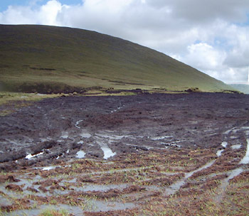
I can agree with csd's comment of 27 April. This is some of the worst high level damage in Wicklow caused, not by hillwalkers, but by bikers or quad bikers. The photo shows the damage to the ground between Slievemaan and Lugnaquillia. So bad is the damage that even after comparatively dry weather it was prudent not to walk on the ground. This is a recent phenomenom. Although it was always a bit wet here, it was easily crossable. Not any more or at least not after rain. I would advise anyone crossing between Slievemaan and Lugnaquillia to beware of the danger of getting stuck. Linkback: mountainviews.ie/summit/70/comment/530/
Read Less
Read More
csd on Slievemaan
by csd
27 Apr 2003
Unfortunately the area around Slievemaan is beginning to get quite scarred by individuals on quad bikes. Nice views of the South Prison on the way up from Aughavanna - almost enough to make up for the long slog up from that direction! Linkback: mountainviews.ie/summit/70/comment/448/
Read Less
Read More
simon3 on Slievemaan
by simon3
2 Jun 2003
The summit of Slievemaan has great views to the south, though not on the day this picture was taken. The picture shows the mini-cairn in front of the impressive bulk of Lugnaquillia. The summit of Lugnaquillia is less than 200m above this point. It can't be seen because it is quite far back from the skyline, across a broad shoulder known as Percy's Table. Linkback: mountainviews.ie/summit/70/comment/531/
Read Less
Read More
berber on Slievemaan
by berber
29 Aug 2002
29-8-2002:In descending south west to get to the road I would advise walkers to walk on the rough ground between the two incised streams. These become more obvious as you descend. Rather than descend to where they join, work right so that you traverse the hill on your right about 300 metres above the junction. This helps in finding the track which serves the houses just out of sight to the west and reduces the number of walls to be crossed. Linkback: mountainviews.ie/summit/70/comment/89/
Read Less
Read More
petelunn on Slievemaan
by petelunn
1 Jun 2004
The mud between Slievemaan and Lug mentioned by others is very severe. We nearly got stuck in wet weather, but eventually managed to get round it on the east side. We couldn't find a way through on the west at all. After descending via Camarahill we had to cross Little Slaney river after several hours persistent rain - not at all easy. One of us waded across. Best to do the circuit so that it's left until last. Linkback: mountainviews.ie/summit/70/comment/981/
Use of MountainViews is governed by conditions and a privacy policy.
Read general information about the site. Opinions in material here are not necessarily endorsed by MountainViews.
Hillwalking is a risk sport. Information in comments, walks, shared GPS tracks or about starting places may
not be accurate for example as regards safety or access permission. You are responsible for your safety and your permission to walk.
See the credits and list definitions.


 Our Facebook page.