Cookies.
This website uses cookies, which are small text files that the website puts on your device to facilitate operation. Cookies help us provide a better service to you. They are used to track general user traffic information and to help the website function properly.
Features
Nearby features appear when you click the map.
Declutter tracks on map.
Place Search
Video
X
Pub: by
Wicklow Area , NW: Blessington Subarea
Feature count in area: 115, by county: Wicklow: 108, Kildare: 4, Wexford: 2, Carlow: 3, of which 1 is in both Wexford and Wicklow, of which 1 is in both Carlow and Wicklow, OSI/LPS Maps: 28B, 55, 56, 61, 62, AWW, EW-DM, EW-LG, EW-WE, EW-WS
Highest Place: Lugnaquilla 924.7m

Starting Places (205) in area Wicklow:
1916 Memorial Car Park, Aghavannagh Ow Bridge, Aghowle Wood, Altidore Wood Entrance, Annacurra National School, Annalecka Bridge, Asbawn Brook L8350, Aughrim National School, Ballard Road, Ballinabarny Gap, Ballinagappoge Bridge Layby, Ballinagappoge Mountain Hairpin, Ballinagore, Ballinahinch Wood, Ballinastoe MBT CP, Ballinastraw South, Ballineddan Upr Fork, Ballinfoyle Upr Cross, Ballycoog, Ballycreen Brook Bridge, Ballycumber, Ballycumber Bridge, Ballycumber Lane, Ballycumber Wicklow Way, Ballylerane, Ballylow Bridge, Ballylusk Quarry, Ballymanus Lane, Ballymoyle Shooting Lodge, Ballynultagh Gap, Ballynultagh Lane, Ballyreagh Wood, Ballyross Forest, Ballysmuttan Long Stone, Baravore, Barnbawn South, Barranisky North, Barranisky West, Bohilla Land Roundabout, Bohilla Lane Mid, Boranaraltry Bridge, Bray Harbour, Brewel West, Brittas Bay North CP, Buckroney Sand Dunes CP, Bus Terminus, Camera Hill Track Cross, Castletimon Wood North, Clara Vale, Clone House Road, Clonegal, Cloon Wood Cp, Coate Bridge, Coolballintaggart Ledge, Coolbawn House Lane, Cransillagh Brook , Crone Wood CP, Crossbridge, Crossoona Rath, Cummer Wood South, Curtlestown Wood CP, Deputy's Pass CP, Derralossary Church, Derry River Bridge, Devil's Glen CP, Devil's Glen Wood, Djouce Wood Calary, Djouce Wood Lake, Djouce Wood Long Hill, Donard, Donnelly's Lane Car Sales, Drumgoff Forest, Dunranhill North, Dunranhill SE, Dunranhill South, Dwyer McAllister Cottage CP, Enniskerry, Fentons Pub, Fitzsimons Park GAA, unuseableFlemings Footbridge Glen Rd, Gap Pub, Gap Road, Glen Beach CP, Glen of the Downs CP, Glenbride Lane, Glenbride Lodge, Glencree Reconciliation, Glendalough, Glenealy GAA, Glenmacnass Tonelagee CP, Glenmalure Hostel, Glenmalure Lodge, Glenmalure Waterfall, Glenview Hotel, Gowle House, Great Sugar Loaf CP, Grove Bar, Heffernans Well Wood, Hill View, Hollywood Glen, JB Malone CP, Johnnie Fox Pub, Keadeen NE trail, Keadeen Trailhead, Kevins Way Footbridge, Kilbride Army Camp Entrance, Kilcandra South, Kilcommon View, Killalongford Wood, Kilmacrea Cross Roads, Kilranelagh House Gate, Kilruddery Car Park, Kilruddery Cottages, Kings River, Kippure Bridge, Kippure Estate, Kippure Transmitter Gate, Knickeen Cross, Knocknaboley Lane Leeraghs Bog, Knocknaboley Lane Stone Cottage, Knockrath Little, Knockree west, Kyle Loop North, Lackan Wood S, Lake Dr Fraughan Brook, Lake Drive, Lake Park Cross, Lake View Pub, Laragh Free Car Park, Laragh NSch, Lead Mines CP, Liffey Bridge, Liffey Head Bridge, Lough Bray Lower, Lough Bray Upper, Lough Tay North Viewing Point, Lough Tay Wicklow Way CP, Luglass Lane L97561, Lugnagun Track, Macreddin Village, Mangans Lane, Military Road Carrigshouk Hill, Military Road Inchavore River Nth, Military Road Inchavore River Sth, Military Road NW Lough Tay, Military Road Ballyboy Bridge, Military Road Cloghoge Brook, Military Road Croaghanmoira, Military Road Fananierin, Military Road LaraghWicklow Way, Military Road Slieve Maan, Monspolien Bridge, Moortown House, Mountain Rescue HQ, Muskeagh Little Wood, Nahanagan Lough NE, Novara Avenue, Bray, Oiltiagh Brook Knickeen, Old Bridge Cross, Old Bridge Scouts , Old Wicklow Way entrance, Paddock Hill SE, Pier Gates CP, Powerscourt Waterfall CP, Putland Road, Quintagh East, Raheen Park CP, Raheenleagh East, Railway Walk CP, Rathdrum Railway Station, Rednagh Wood, Rocky Valley, Roundwood, Sally Gap, Sally Gap N, Seefin Trailhead, Seskin SE, Shankill Tributary Bridge, Shay Elliott, Sheepshanks Bridge, Shillelagh, Slievecorragh Track, Slievefoore South, Sraghoe Brook, St John's Church, St Kevins Chair, St Kevins Church, St Kevins Way R756, Stone Circle Bridge, Stookeen South, Stranahely Wood, Stranakelly Cross Roads, Tallyho, Templeboden, Tithewer, Tomcoyle L, Tomriland Wood, Toor Brook, Trooperstown Hill Access, Turlough Hill CP, Upper Lake CP, Vallymount GAA CP, Vartry Reservoir Upper, Zellers Pub

Summits & other features in area Wicklow:
Cen: Glendalough North: Brockagh Mountain 556.9m, Brockagh Mountain NW Top 549.5m, Brockagh Mountain SE Top 471.7m, Camaderry East Top 677.3m, Camaderry Mountain 698.6m, Conavalla 734m, Tomaneena 682.4m
Cen: Glendalough South: Carriglineen Mountain 456.6m, Cullentragh Mountain 510m, Derrybawn Mountain 476.1m, Kirikee Mountain 474.5m, Lugduff 653.2m, Lugduff SE Top 638m, Mullacor 660.7m, Trooperstown Hill 430m
N Cen: Tonelagee: Carrignagunneen 561m, Fair Mountain 571.2m, Stoney Top 713.7m, Tonelagee 815.8m, Tonelagee E Top 668m, Tonelagee South-East Top 545.8m
NE: Bray & Kilmacanogue: Bray Head Hill 238.9m, Carrigoona Commons East 242m, Downs Hill 372.9m, Great Sugar Loaf 501.2m, Little Sugar Loaf 342.4m
NE: Djouce: Djouce 725.5m, Knockree 342.1m, Maulin 570m, Tonduff 642m, Tonduff East Top 593m, War Hill 684.8m, White Hill 631.1m
NE: Fancy: Ballinafunshoge 480m, Kanturk 527.4m, Knocknacloghoge 532.4m, Luggala 593.3m, Robber's Pass Hill 508.9m, Scarr 640m, Scarr North-West Top 559.8m, Sleamaine 430m
NE: Vartry: Ballinacorbeg 336m, Ballycurry 301m, Dunranhill 342m, Mount Kennedy 365.9m
NW: Blessington: Carrigleitrim 408m, Lugnagun 446.2m, Slieveroe 332m, Sorrel Hill 599.5m
NW: Mullaghcleevaun: Black Hill 602.2m, Carrigshouk 572.5m, Carrigvore 682.4m, Duff Hill 720.8m, Gravale 719m, Moanbane 703m, Mullaghcleevaun 846.7m, Mullaghcleevaun East Top 796m, Silsean 698m
S: Aughrim Hills: Cushbawn 400m, Killeagh 249m, Moneyteige North 427m, Preban Hill 389m
S: Croaghanmoira: Ballinacor Mountain 529.3m, Ballycurragh Hill 536m, Ballyteige 447m, Carrickashane Mountain 508m, Croaghanmoira 662.3m, Croaghanmoira North Top 579.5m, Fananierin 426m, Slieve Maan 547.8m, Slieve Maan North Top 546.1m
S: Croghan Kinsella: Annagh Hill 454m, Croghan Kinsella 606m, Croghan Kinsella East Top 562.1m, Slievefoore 414m
S: Shillelagh Hills: Lakeen 357m, Monaughrim 206m, Seskin 344m, Stookeen 420m
S: Tinahely Hills: Ballycumber Hill 429.7m, Eagle Hill 296m, Muskeagh Hill 398.2m
SE: Wicklow South East: Ballinastraw 284m, Ballyguile Hill 188m, Barranisky 280m, Carrick Mountain 381m, Collon Hill 238m, Kilnamanagh Hill 217m, Westaston Hill 270m
W: Baltinglass: Ballyhook Hill 288m, Baltinglass Hill 382m, Carrig Mountain 571m, Carrigeen Hill 298m, Cloghnagaune 385m, Corballis Hill 258m, Keadeen Mountain 653m, Spinans Hill 409m, Spinans Hill SE Top 400m, Tinoran Hill 312m
W: Cen Lugnaquilla: Ballineddan Mountain 652.3m, Benleagh 689m, Camenabologue 758m, Camenabologue SE Top 663m, Cloghernagh 800m, Corrigasleggaun 794.6m, Lugnaquilla 924.7m, Slievemaan 759.7m
W: Donard: Brewel Hill 222m, Church Mountain 544m, Corriebracks 531m, Lobawn 636m, Slievecorragh 418m, Sugarloaf 552m, Table Mountain 701.7m, Table Mountain West Top 563m

Note: this list of places may include island features such as summits, but not islands as such.
Rating graphic.
Lugnagun, 446.2m Hill Log na gCon A name in Irish,
Place Rating ..
, Blackamore Hill, Black Moor Hill, Wicklow County in Leinster province, in Carn Lists, Lugnagun is the 747th highest place in Ireland.
Grid Reference O01248 12478, OS 1:50k mapsheet 56
Place visited by: 209 members, recently by: KateLeckie, Carolineswalsh, NualaB, nupat, MickM45, Kaszmirek78, michaelseaver, John.geary, jimmytherabbit, marcellawalking, SenanFoley, Ansarlodge, grzywaczmarcin, loftyobrien, srr45
I visited this place: NO (You need to be a logged-in member for this.)
Longitude: -6.487318, Latitude: 53.153464, Easting: 301248, Northing: 212478, Prominence: 43m,  Isolation: 3km
ITM: 701175 712508
Bedrock type: Basalt and gabbro, (Dolerite)

  Short or GPS IDs, 6 char: Lgngn, 10 char: Lugnagun

Linkback: https://mountainviews.ie/summit/633/
Gallery for Lugnagun (Log na gCon) and surrounds
Summary for Lugnagun (Log na gCon): Superb Blessington Lake Views
Summary created by simon3, march-fixer 2013-06-23 21:32:06
            MountainViews.ie picture about Lugnagun (<em>Log na gCon</em>)
Picture: Lugnagun from the east.
Though not a summit to write home about, it still provides a wonderful grandstand view south out over Blessington Lakes and west to the Hill of Allen. Until recently (2013) pine trees obscure these lovely views from the summit. Now that this area of the plantation has been harvested there is a 360 degree panorama available. Lugnagun is an ideal launching pad for an attack on Sorrel Hill. From Lugnagun summit there is a nice linear ditch feature running south-east and then a relatively good track all the way to the summit of Sorrel Hill. On the way to Sorrel Hill you may wish to visit the remains of a Megalithic Tomb at A (O02172 11919), just inside the forest edge.

It is best to approach from the Blessington direction and head across the bridge towards Ballyknockan along the Lake Drive until B (N99270 12400) where you take a steep left-hand turn up Carrig. Continue up this road to the forest entrance at LugGun Tr (O00274 12314) where there is parking for about four cars (you may get more parking at the very end of this road). The forest track zig-zags up until you pick up a forest track at C (O01123 12327). Follow this rough track to close to the summit. Summit in this case is a subjective guess!
Linkback: mountainviews.ie/summit/633/comment/5392/
Member Comments for Lugnagun (Log na gCon)
Comment create / edit display placeholder

            MountainViews.ie picture about Lugnagun (<em>Log na gCon</em>)
darrenf on Lugnagun
by darrenf 18 Mar 2010
From Sorrel Hill a clear and wide track will take you directly down to spot height 427. Views over the reservoir will stay wit you the whole way. From this angle the outline of Sorrel Hill looks more impressive. The track will lead you right accross the shoulder to Lugnagun. The forest will be on your left hand side for most of this ridge and provides excellent shelter from the cutting wind.

The top itself is elusive. There are no cairns, mounds, or markers of any shape. I reckon my photo below was taken in much the same location as wicklores and I would have to agree with him that this is the most probable location of the summit. As you can see from the photo there is now a stile over the forest fence at this location which after 70-80m drops you onto the main forestery tracks indicated on sheet 56. It should be noted that on numerous occassions along these forest trackes I encountered large fallen trees blocking the track. In most cases you can push your way through the fallen trees or skirt around. Following this track will eventually take you back to the road and from here its a straightforward slog back to the carpark. Total distance 8.6km over 1hr 50 min. Linkback: mountainviews.ie/summit/633/comment/4520/
Read Less
Read More

            MountainViews.ie picture about Lugnagun (<em>Log na gCon</em>)
Picture: Lugnagun summit...ish!!
On the summit... I think!!
by Dessie1 24 Sep 2010
Climbed Lugnagun from small cul de sac road point D (O018 125) on 24-9-10. Relatively easy but boggy quick climb from car. Followed fencing to all the way to top.Quite confusing as to exact summit so celebrated the whole way along the ridge of trees! Not much else to comment on Lugnagun except for the fine views of Sorrel hill,mullaghcleevaun Kippure etc which dominate the horizon.Thank god this is off my list of to do's now! Linkback: mountainviews.ie/summit/633/comment/6107/
Read Less
Read More

            MountainViews.ie picture about Lugnagun (<em>Log na gCon</em>)
Picture: Do these sticks mark the high point of Lugnagun?
wicklore on Lugnagun
by wicklore 14 Jul 2008
I just wanted to bag this hill as a part of a hill-bagging frenzy on Sunday. I found my way to D (O018 125) and parked in one of the many small cut-outs designed to allow cars to pass on this narrow road. I was feeling unsure about setting off uphill across farmland so I waved down a passing man in a tractor. He said that he didn't see a problem as long as I didn't damage fences or block the lane. He pointed out that he didn't own those fields. I crossed a number of fences on the way up and they are well maintained with none of the usual damage or easy crossing points. These hills are small but tough hauls. When I reached the forestry at the top and turned right to cross another fence, someone had thoughtfully insulated the barbed wire with cloth and padding. As with csd and Kaybee I had to guess the summit. I chose what I considered to be the highest point (by several millimetres) on the earth bank alonside the forest. My photo shows the view towards Sorrell Hill with my sticks marking the imagined 'summit'. I agree with csd that Lugnagun could be easily incorporated into a Sorrell Hill walk. Or else you could just spend the afternoon with a theodolite finding the elusive high point! Linkback: mountainviews.ie/summit/633/comment/3217/
Read Less
Read More

            MountainViews.ie picture about Lugnagun (<em>Log na gCon</em>)
Picture: View down to Pollaphuca from stile near summit
All is changed, changed utterly, a terrible beauty is born!
by Trailtrekker 19 Feb 2013
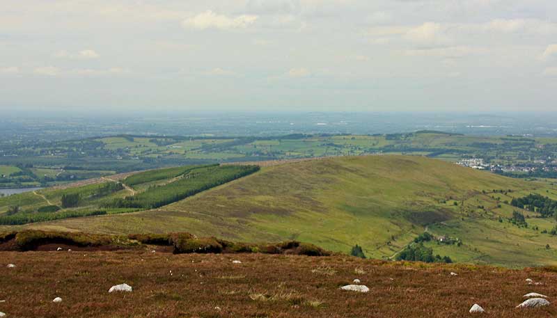
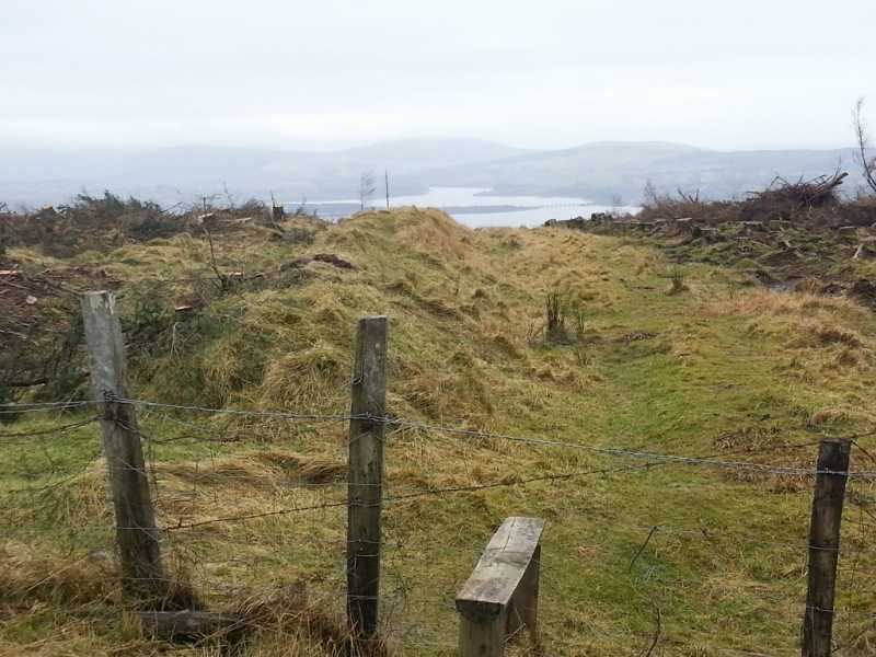
Well not quite and I'm sure that Yeats himself would think that quote itself is a bit misplaced. However, there has been one very significant change to this area since all previous comments and it does have a significant affect on the view, access and the summit! The forest to the south and south west of the summit area has been harvested. A number of the trees that have not been cleared lie across the fence protruding into field and making a dance along the summit ridge as Dessie has done, a lot more cumbersome! The harvesting has also meant that the approach to the summit through the forestry is now clear, with no obstructions along the route. Finally, you now have 360 degree views from summit, looking over the battered remains of the forestry you can see the beautiful views to the south. (OK, maybe there is one tenuous parallel between this hill and Easter 1916).

I did Lugnagun very recently as part of a circuit that included Sorrell and the god forsaken Carrigleitrim. This meant that I was approaching Lugnagun from the forestry on the north east of Sorrell and heading for the 427M spot height in between the two summits. From here, as already mentioned, there is a clear and boggy track to Lugnagun. I did jump along the different humps of ground on the summit to make pretty sure that I had indeed stood on the highest point. From here I decided to follow the track on to the edge of the forest where I saw there was a cairn marked on the osi map. The cairn is the type that I have commonly found in this area, overgrown and unworthy of examination in it's own right, I could however see why it was located in this area, as it does provide probably the best view of any spot on this hill.

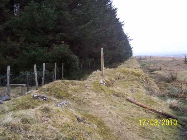
From here I retraced my steps to the stile near the summit and headed into the deforested area, as already mentioned by darrenf you will soon pick up a forest track at C (O01123 12327), turn left and follow it to a gate on the edge of the forestry at E (O02472 11578), from here it is straightforward farmers tracks down through the field to join the road at F (O03012 11152). For me it was just under 2km on this quiet road back to the car to complete my 14k walk for the day. Linkback: mountainviews.ie/summit/633/comment/14928/
Read Less
Read More

            MountainViews.ie picture about Lugnagun (<em>Log na gCon</em>)
Picture: Art or litter?
A dash of colour on a dull day
by wicklore 22 Dec 2014
Not being able to be at Newgrange (having never applied for a ticket in my life) I decided to celebrate the winter solstice by watching the sun rise from a Wicklow hill. I planned to welcome the sun and speak encouraging words to it and let it know that from here on in it got easier for the next 6 months until the summer solstice in 2015.

Timeanddate.com told me sunrise would be at 8:38am. I got up early and made my way to the car park between Black and Sorrel Hills in the Wicklow Mountains. A slow start meant that sunrise found me high on Sorrel Hill, and not Lugnagun as planned. At 8:38am the glorious first rays of the sun peeping over the eastern Wicklow hills were completely denied to me by a persistent and typical blanket of cloud that soaked me and prevented me seeing more than 50 feet in any direction. Instead of warm and friendly sunlight I was surrounded by a dull, grey cloud that sneaked beneath my layers and chilled me. There was no moment of sunrise – just a slight lightening of the dreary enveloping cloud. I trudged on nonetheless as I expected something interesting to happen as so often does on my forays into the hills.

The route up Sorrel is a well-worn scar of exposed black bog which is wet and slippy and ever expanding by the trample of endless feet. On the road at the start of the track someone has spray painted arrows and information for the participants of some ‘pro race’ or other, pointing the hordes up Sorrell Hill. But that was another time and this early in the morning only the cold wind made any sound to accompany my heavy breathing and sucking footsteps. The summit carn of jumbled rock and stones loomed through the cloud and after a brief, chilly stop I descended westwards to find the ridge to Lugnagun.

According to the date on a summit comment I had previously written, it was 6 years since I had visited Lugnagun. I was quite taken aback by this – it felt like only recently that I had clambered up the short slope from the road below. 6 years? As I walked along my reverie was broken by something white on the ground. On closer inspection it turned out to be a small Christmas teddy bear- the type that hangs on a Christmas tree. Then I found another one. And another one. They were scattered around the heather. There was tinsel too, and baubles. Lots of baubles. Perplexed I looked around and there it was! A Christmas tree! Someone had decorated a tree just where the forest stopped and deforestation started near the summit. But the deforestation meant that a steady wind blew through the area and had stripped most of the decorations off the tree. They were scattered about the nearby hillside. I rescued 4 teddy bears and 4 Santas in total and decided to give them a safe and permanent home back in Dublin. They now occupy a warm and wind-free place high up on an indoor tree! Something interesting usually happens when I get out on the hills, and today was no different! Linkback: mountainviews.ie/summit/633/comment/17765/
Read Less
Read More
EDIT Point of Interest
text
Videos


Recent Contributions
x
Conditions and Info
Use of MountainViews is governed by conditions and a privacy policy.
Read general information about the site.
Opinions in material here are not necessarily endorsed by MountainViews.
Hillwalking is a risk sport. Information in comments, walks, shared GPS tracks or about starting places may not be accurate for example as regards safety or access permission. You are responsible for your safety and your permission to walk.
See the credits and list definitions.

OSi logo
OSNI/LPS logo
Open Street Map
(Various variations used.)
British summit data courtesy:
Database of British & Irish Hills