This website uses cookies, which are small text files that the website puts on your device to facilitate operation. Cookies help us provide a better service to you. They are used to track general user traffic information and to help the website function properly.
Feature count in area: 115, by county: Wicklow: 108, Kildare: 4, Wexford: 2, Carlow: 3, of which 1 is in both Wexford and Wicklow, of which 1 is in both Carlow and Wicklow,
OSI/LPS Maps: 28B, 55, 56, 61, 62, AWW, EW-DM, EW-LG, EW-WE, EW-WS
Highest Place: Lugnaquilla 924.7m
Starting Places (205) in area Wicklow: 1916 Memorial Car Park, Aghavannagh Ow Bridge, Aghowle Wood, Altidore Wood Entrance, Annacurra National School, Annalecka Bridge, Asbawn Brook L8350, Aughrim National School, Ballard Road, Ballinabarny Gap, Ballinagappoge Bridge Layby, Ballinagappoge Mountain Hairpin, Ballinagore, Ballinahinch Wood, Ballinastoe MBT CP, Ballinastraw South, Ballineddan Upr Fork, Ballinfoyle Upr Cross, Ballycoog, Ballycreen Brook Bridge, Ballycumber, Ballycumber Bridge, Ballycumber Lane, Ballycumber Wicklow Way, Ballylerane, Ballylow Bridge, Ballylusk Quarry, Ballymanus Lane, Ballymoyle Shooting Lodge, Ballynultagh Gap, Ballynultagh Lane, Ballyreagh Wood, Ballyross Forest, Ballysmuttan Long Stone, Baravore, Barnbawn South, Barranisky North, Barranisky West, Bohilla Land Roundabout, Bohilla Lane Mid, Boranaraltry Bridge, Bray Harbour, Brewel West, Brittas Bay North CP, Buckroney Sand Dunes CP, Bus Terminus, Camera Hill Track Cross, Castletimon Wood North, Clara Vale, Clone House Road, Clonegal, Cloon Wood Cp, Coate Bridge, Coolballintaggart Ledge, Coolbawn House Lane, Cransillagh Brook , Crone Wood CP, Crossbridge, Crossoona Rath, Cummer Wood South, Curtlestown Wood CP, Deputy's Pass CP, Derralossary Church, Derry River Bridge, Devil's Glen CP, Devil's Glen Wood, Djouce Wood Calary, Djouce Wood Lake, Djouce Wood Long Hill, Donard, Donnelly's Lane Car Sales, Drumgoff Forest, Dunranhill North, Dunranhill SE, Dunranhill South, Dwyer McAllister Cottage CP, Enniskerry, Fentons Pub, Fitzsimons Park GAA, unuseableFlemings Footbridge Glen Rd, Gap Pub, Gap Road, Glen Beach CP, Glen of the Downs CP, Glenbride Lane, Glenbride Lodge, Glencree Reconciliation, Glendalough, Glenealy GAA, Glenmacnass Tonelagee CP, Glenmalure Hostel, Glenmalure Lodge, Glenmalure Waterfall, Glenview Hotel, Gowle House, Great Sugar Loaf CP, Grove Bar, Heffernans Well Wood, Hill View, Hollywood Glen, JB Malone CP, Johnnie Fox Pub, Keadeen NE trail, Keadeen Trailhead, Kevins Way Footbridge, Kilbride Army Camp Entrance, Kilcandra South, Kilcommon View, Killalongford Wood, Kilmacrea Cross Roads, Kilranelagh House Gate, Kilruddery Car Park, Kilruddery Cottages, Kings River, Kippure Bridge, Kippure Estate, Kippure Transmitter Gate, Knickeen Cross, Knocknaboley Lane Leeraghs Bog, Knocknaboley Lane Stone Cottage, Knockrath Little, Knockree west, Kyle Loop North, Lackan Wood S, Lake Dr Fraughan Brook, Lake Drive, Lake Park Cross, Lake View Pub, Laragh Free Car Park, Laragh NSch, Lead Mines CP, Liffey Bridge, Liffey Head Bridge, Lough Bray Lower, Lough Bray Upper, Lough Tay North Viewing Point, Lough Tay Wicklow Way CP, Luglass Lane L97561, Lugnagun Track, Macreddin Village, Mangans Lane, Military Road Carrigshouk Hill, Military Road Inchavore River Nth, Military Road Inchavore River Sth, Military Road NW Lough Tay, Military Road Ballyboy Bridge, Military Road Cloghoge Brook, Military Road Croaghanmoira, Military Road Fananierin, Military Road LaraghWicklow Way, Military Road Slieve Maan, Monspolien Bridge, Moortown House, Mountain Rescue HQ, Muskeagh Little Wood, Nahanagan Lough NE, Novara Avenue, Bray, Oiltiagh Brook Knickeen, Old Bridge Cross, Old Bridge Scouts , Old Wicklow Way entrance, Paddock Hill SE, Pier Gates CP, Powerscourt Waterfall CP, Putland Road, Quintagh East, Raheen Park CP, Raheenleagh East, Railway Walk CP, Rathdrum Railway Station, Rednagh Wood, Rocky Valley, Roundwood, Sally Gap, Sally Gap N, Seefin Trailhead, Seskin SE, Shankill Tributary Bridge, Shay Elliott, Sheepshanks Bridge, Shillelagh, Slievecorragh Track, Slievefoore South, Sraghoe Brook, St John's Church, St Kevins Chair, St Kevins Church, St Kevins Way R756, Stone Circle Bridge, Stookeen South, Stranahely Wood, Stranakelly Cross Roads, Tallyho, Templeboden, Tithewer, Tomcoyle L, Tomriland Wood, Toor Brook, Trooperstown Hill Access, Turlough Hill CP, Upper Lake CP, Vallymount GAA CP, Vartry Reservoir Upper, Zellers Pub
Summits & other features in area Wicklow: Cen: Glendalough North: Brockagh Mountain 556.9m, Brockagh Mountain NW Top 549.5m, Brockagh Mountain SE Top 471.7m, Camaderry East Top 677.3m, Camaderry Mountain 698.6m, Conavalla 734m, Tomaneena 682.4m Cen: Glendalough South: Carriglineen Mountain 456.6m, Cullentragh Mountain 510m, Derrybawn Mountain 476.1m, Kirikee Mountain 474.5m, Lugduff 653.2m, Lugduff SE Top 638m, Mullacor 660.7m, Trooperstown Hill 430m N Cen: Tonelagee: Carrignagunneen 561m, Fair Mountain 571.2m, Stoney Top 713.7m, Tonelagee 815.8m, Tonelagee E Top 668m, Tonelagee South-East Top 545.8m NE: Bray & Kilmacanogue: Bray Head Hill 238.9m, Carrigoona Commons East 242m, Downs Hill 372.9m, Great Sugar Loaf 501.2m, Little Sugar Loaf 342.4m NE: Djouce: Djouce 725.5m, Knockree 342.1m, Maulin 570m, Tonduff 642m, Tonduff East Top 593m, War Hill 684.8m, White Hill 631.1m NE: Fancy: Ballinafunshoge 480m, Kanturk 527.4m, Knocknacloghoge 532.4m, Luggala 593.3m, Robber's Pass Hill 508.9m, Scarr 640m, Scarr North-West Top 559.8m, Sleamaine 430m NE: Vartry: Ballinacorbeg 336m, Ballycurry 301m, Dunranhill 342m, Mount Kennedy 365.9m NW: Blessington: Carrigleitrim 408m, Lugnagun 446.2m, Slieveroe 332m, Sorrel Hill 599.5m NW: Mullaghcleevaun: Black Hill 602.2m, Carrigshouk 572.5m, Carrigvore 682.4m, Duff Hill 720.8m, Gravale 719m, Moanbane 703m, Mullaghcleevaun 846.7m, Mullaghcleevaun East Top 796m, Silsean 698m S: Aughrim Hills: Cushbawn 400m, Killeagh 249m, Moneyteige North 427m, Preban Hill 389m S: Croaghanmoira: Ballinacor Mountain 529.3m, Ballycurragh Hill 536m, Ballyteige 447m, Carrickashane Mountain 508m, Croaghanmoira 662.3m, Croaghanmoira North Top 579.5m, Fananierin 426m, Slieve Maan 547.8m, Slieve Maan North Top 546.1m S: Croghan Kinsella: Annagh Hill 454m, Croghan Kinsella 606m, Croghan Kinsella East Top 562.1m, Slievefoore 414m S: Shillelagh Hills: Lakeen 357m, Monaughrim 206m, Seskin 344m, Stookeen 420m S: Tinahely Hills: Ballycumber Hill 429.7m, Eagle Hill 296m, Muskeagh Hill 398.2m SE: Wicklow South East: Ballinastraw 284m, Ballyguile Hill 188m, Barranisky 280m, Carrick Mountain 381m, Collon Hill 238m, Kilnamanagh Hill 217m, Westaston Hill 270m W: Baltinglass: Ballyhook Hill 288m, Baltinglass Hill 382m, Carrig Mountain 571m, Carrigeen Hill 298m, Cloghnagaune 385m, Corballis Hill 258m, Keadeen Mountain 653m, Spinans Hill 409m, Spinans Hill SE Top 400m, Tinoran Hill 312m W: Cen Lugnaquilla: Ballineddan Mountain 652.3m, Benleagh 689m, Camenabologue 758m, Camenabologue SE Top 663m, Cloghernagh 800m, Corrigasleggaun 794.6m, Lugnaquilla 924.7m, Slievemaan 759.7m W: Donard: Brewel Hill 222m, Church Mountain 544m, Corriebracks 531m, Lobawn 636m, Slievecorragh 418m, Sugarloaf 552m, Table Mountain 701.7m, Table Mountain West Top 563m
Note: this list of places may include island features such as summits, but not
islands as such.
Carrigshouk, 572.5mMountain Carraig an tSeabhaic A name in Irish,
Place Rating ..
, Cyowck, Carrigalough, Wicklow County in Leinster province, in Arderin Lists, Carrigshouk is the 355th highest place in Ireland.
Grid Reference O09791 05164,
OS 1:50k mapsheet 56 Place visited by: 266members, recently by: Sarahjb, KateLeckie, Kaszmirek78, muddypaws, gavdeer, 500plusclub, hak493r, oreills8, NualaB, Timmy.Mullen, chelman7, lauracardiff, Jai-mckinney, Carolyn105, BrianKennan
I visited this place: NO (You need to be a logged-in member for this.)
Short or GPS IDs, 6 char: Crgshk, 10 char: Carigshouk Linkback: https://mountainviews.ie/summit/1058/
Gallery for Carrigshouk (Carraig an tSeabhaic) and surrounds
Summary
for Carrigshouk (Carraig an tSeabhaic):
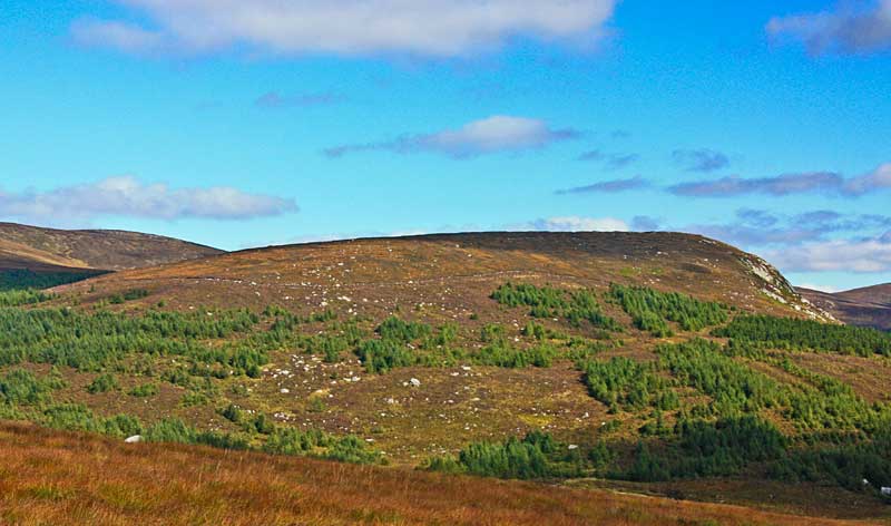
Low cliffy mountain in the middle of the Wicklow massif.
Summary created by simon3
2013-09-23 14:59:26
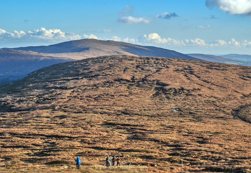
Picture: Carrigshouk from the SW.
Carrigshouk is probably seldom a target in itself but lends itself to being part of walks to the wilder parts of Wicklow west of the Military Road. Unusually it is steeper to the South East rather than North or North East.
A obvious place to start from is around CShouk (O1027 0525) or other places nearby. It is possible to ascend by heading more or less directly east from there - 60-70 minutes round trip.. Also approximately SE of the top there is a rough track that heads west and curves around the SW side of the summit to arrive at the col between the top and Mullaghcleevaun East Top.
Just happened upon this "new" summit on Mountainviews, this evening and feel I have to give it a short comment, Always good to be first to do so!
For as long as this summit has been on the "excluded" list it has been unfortunate as it has been crossed by many I'm certain, mainly as the entry or exit to Mullaghcleevaun (via East Top).
It has lovely views as you come down SE towards the R115, looking over Luggala, Knocknacloghoge and Kanturk/Scarr as they frame the beautiful jewel that is Lough Dan.
The forestry to the west and south of the hill has a (very rough) track running along the boundary fenceline which despite it's dreadful underfoot condition is a good way of making progress past the summit, which one can bag in passing.
Anyway, thanks to Simon et al for the return from exile of this summit. Linkback: mountainviews.ie/summit/1058/comment/6685/
Read Less
Read More
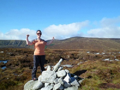
Picture: Success
Yay only 1 more summit to go :)
by LizzieMurray
8 Oct 2012
After years driving by this lovely looking mountain finally had the guts to conquer it yesterday 6th October 2012. It is even steeper than it looks what with me being a novice still. We made our way up the gully towards the summit cairn. Was quite taxing but well worth it on the day we had. The weather was fabulous and the views were amazing. A fabulous warm up to get on and do Mullaghcleevaun East Top and stop for a spot of lunch and a well deserved cuppa. Wrap up though, tis rather chilly up there :) Linkback: mountainviews.ie/summit/1058/comment/14832/
Read Less
Read More
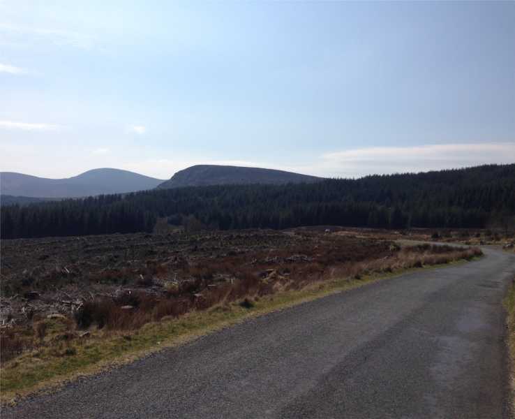
Picture: Carrigshouk from Military road
Perfect Strating point
by Sarkuns
23 Apr 2014
Carrigshouk on 22.04.2014 as a starting point for around 7-8h walking rout.
Taking a straight forward approach it took me approximately 30 min to get to the summit from CShouk (O1027 0525) . Pretty steep and rocky slope, with some interesting stone structures. And excellent views from the top. Linkback: mountainviews.ie/summit/1058/comment/16031/
Read Less
Read More
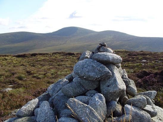
Picture: Tonelagee from Carrigshouk summit cairn
I'm all shouk up!!
by Dessie1
16 Feb 2012
Climbed Carrigshouk from R115 small parking area (A (O10206 05180)) on route to Mullaghcleevaun East top and main top.Follow track from car park area and after roughly 200m of track head directly east to Summit which contains a small cairn of stone and some great panoramas. Linkback: mountainviews.ie/summit/1058/comment/6688/
Read Less
Read More
Picture: Carrigshouk from the NW, with Scarr in the backgound.
Use of MountainViews is governed by conditions and a privacy policy.
Read general information about the site. Opinions in material here are not necessarily endorsed by MountainViews.
Hillwalking is a risk sport. Information in comments, walks, shared GPS tracks or about starting places may
not be accurate for example as regards safety or access permission. You are responsible for your safety and your permission to walk.
See the credits and list definitions.


 Our Facebook page.