This website uses cookies, which are small text files that the website puts on your device to facilitate operation. Cookies help us provide a better service to you. They are used to track general user traffic information and to help the website function properly.
Feature count in area: 115, by county: Wicklow: 108, Kildare: 4, Wexford: 2, Carlow: 3, of which 1 is in both Wexford and Wicklow, of which 1 is in both Carlow and Wicklow,
OSI/LPS Maps: 28B, 55, 56, 61, 62, AWW, EW-DM, EW-LG, EW-WE, EW-WS
Highest Place: Lugnaquilla 924.7m
Starting Places (205) in area Wicklow: 1916 Memorial Car Park, Aghavannagh Ow Bridge, Aghowle Wood, Altidore Wood Entrance, Annacurra National School, Annalecka Bridge, Asbawn Brook L8350, Aughrim National School, Ballard Road, Ballinabarny Gap, Ballinagappoge Bridge Layby, Ballinagappoge Mountain Hairpin, Ballinagore, Ballinahinch Wood, Ballinastoe MBT CP, Ballinastraw South, Ballineddan Upr Fork, Ballinfoyle Upr Cross, Ballycoog, Ballycreen Brook Bridge, Ballycumber, Ballycumber Bridge, Ballycumber Lane, Ballycumber Wicklow Way, Ballylerane, Ballylow Bridge, Ballylusk Quarry, Ballymanus Lane, Ballymoyle Shooting Lodge, Ballynultagh Gap, Ballynultagh Lane, Ballyreagh Wood, Ballyross Forest, Ballysmuttan Long Stone, Baravore, Barnbawn South, Barranisky North, Barranisky West, Bohilla Land Roundabout, Bohilla Lane Mid, Boranaraltry Bridge, Bray Harbour, Brewel West, Brittas Bay North CP, Buckroney Sand Dunes CP, Bus Terminus, Camera Hill Track Cross, Castletimon Wood North, Clara Vale, Clone House Road, Clonegal, Cloon Wood Cp, Coate Bridge, Coolballintaggart Ledge, Coolbawn House Lane, Cransillagh Brook , Crone Wood CP, Crossbridge, Crossoona Rath, Cummer Wood South, Curtlestown Wood CP, Deputy's Pass CP, Derralossary Church, Derry River Bridge, Devil's Glen CP, Devil's Glen Wood, Djouce Wood Calary, Djouce Wood Lake, Djouce Wood Long Hill, Donard, Donnelly's Lane Car Sales, Drumgoff Forest, Dunranhill North, Dunranhill SE, Dunranhill South, Dwyer McAllister Cottage CP, Enniskerry, Fentons Pub, Fitzsimons Park GAA, unuseableFlemings Footbridge Glen Rd, Gap Pub, Gap Road, Glen Beach CP, Glen of the Downs CP, Glenbride Lane, Glenbride Lodge, Glencree Reconciliation, Glendalough, Glenealy GAA, Glenmacnass Tonelagee CP, Glenmalure Hostel, Glenmalure Lodge, Glenmalure Waterfall, Glenview Hotel, Gowle House, Great Sugar Loaf CP, Grove Bar, Heffernans Well Wood, Hill View, Hollywood Glen, JB Malone CP, Johnnie Fox Pub, Keadeen NE trail, Keadeen Trailhead, Kevins Way Footbridge, Kilbride Army Camp Entrance, Kilcandra South, Kilcommon View, Killalongford Wood, Kilmacrea Cross Roads, Kilranelagh House Gate, Kilruddery Car Park, Kilruddery Cottages, Kings River, Kippure Bridge, Kippure Estate, Kippure Transmitter Gate, Knickeen Cross, Knocknaboley Lane Leeraghs Bog, Knocknaboley Lane Stone Cottage, Knockrath Little, Knockree west, Kyle Loop North, Lackan Wood S, Lake Dr Fraughan Brook, Lake Drive, Lake Park Cross, Lake View Pub, Laragh Free Car Park, Laragh NSch, Lead Mines CP, Liffey Bridge, Liffey Head Bridge, Lough Bray Lower, Lough Bray Upper, Lough Tay North Viewing Point, Lough Tay Wicklow Way CP, Luglass Lane L97561, Lugnagun Track, Macreddin Village, Mangans Lane, Military Road Carrigshouk Hill, Military Road Inchavore River Nth, Military Road Inchavore River Sth, Military Road NW Lough Tay, Military Road Ballyboy Bridge, Military Road Cloghoge Brook, Military Road Croaghanmoira, Military Road Fananierin, Military Road LaraghWicklow Way, Military Road Slieve Maan, Monspolien Bridge, Moortown House, Mountain Rescue HQ, Muskeagh Little Wood, Nahanagan Lough NE, Novara Avenue, Bray, Oiltiagh Brook Knickeen, Old Bridge Cross, Old Bridge Scouts , Old Wicklow Way entrance, Paddock Hill SE, Pier Gates CP, Powerscourt Waterfall CP, Putland Road, Quintagh East, Raheen Park CP, Raheenleagh East, Railway Walk CP, Rathdrum Railway Station, Rednagh Wood, Rocky Valley, Roundwood, Sally Gap, Sally Gap N, Seefin Trailhead, Seskin SE, Shankill Tributary Bridge, Shay Elliott, Sheepshanks Bridge, Shillelagh, Slievecorragh Track, Slievefoore South, Sraghoe Brook, St John's Church, St Kevins Chair, St Kevins Church, St Kevins Way R756, Stone Circle Bridge, Stookeen South, Stranahely Wood, Stranakelly Cross Roads, Tallyho, Templeboden, Tithewer, Tomcoyle L, Tomriland Wood, Toor Brook, Trooperstown Hill Access, Turlough Hill CP, Upper Lake CP, Vallymount GAA CP, Vartry Reservoir Upper, Zellers Pub
Summits & other features in area Wicklow: Cen: Glendalough North: Brockagh Mountain 556.9m, Brockagh Mountain NW Top 549.5m, Brockagh Mountain SE Top 471.7m, Camaderry East Top 677.3m, Camaderry Mountain 698.6m, Conavalla 734m, Tomaneena 682.4m Cen: Glendalough South: Carriglineen Mountain 456.6m, Cullentragh Mountain 510m, Derrybawn Mountain 476.1m, Kirikee Mountain 474.5m, Lugduff 653.2m, Lugduff SE Top 638m, Mullacor 660.7m, Trooperstown Hill 430m N Cen: Tonelagee: Carrignagunneen 561m, Fair Mountain 571.2m, Stoney Top 713.7m, Tonelagee 815.8m, Tonelagee E Top 668m, Tonelagee South-East Top 545.8m NE: Bray & Kilmacanogue: Bray Head Hill 238.9m, Carrigoona Commons East 242m, Downs Hill 372.9m, Great Sugar Loaf 501.2m, Little Sugar Loaf 342.4m NE: Djouce: Djouce 725.5m, Knockree 342.1m, Maulin 570m, Tonduff 642m, Tonduff East Top 593m, War Hill 684.8m, White Hill 631.1m NE: Fancy: Ballinafunshoge 480m, Kanturk 527.4m, Knocknacloghoge 532.4m, Luggala 593.3m, Robber's Pass Hill 508.9m, Scarr 640m, Scarr North-West Top 559.8m, Sleamaine 430m NE: Vartry: Ballinacorbeg 336m, Ballycurry 301m, Dunranhill 342m, Mount Kennedy 365.9m NW: Blessington: Carrigleitrim 408m, Lugnagun 446.2m, Slieveroe 332m, Sorrel Hill 599.5m NW: Mullaghcleevaun: Black Hill 602.2m, Carrigshouk 572.5m, Carrigvore 682.4m, Duff Hill 720.8m, Gravale 719m, Moanbane 703m, Mullaghcleevaun 846.7m, Mullaghcleevaun East Top 796m, Silsean 698m S: Aughrim Hills: Cushbawn 400m, Killeagh 249m, Moneyteige North 427m, Preban Hill 389m S: Croaghanmoira: Ballinacor Mountain 529.3m, Ballycurragh Hill 536m, Ballyteige 447m, Carrickashane Mountain 508m, Croaghanmoira 662.3m, Croaghanmoira North Top 579.5m, Fananierin 426m, Slieve Maan 547.8m, Slieve Maan North Top 546.1m S: Croghan Kinsella: Annagh Hill 454m, Croghan Kinsella 606m, Croghan Kinsella East Top 562.1m, Slievefoore 414m S: Shillelagh Hills: Lakeen 357m, Monaughrim 206m, Seskin 344m, Stookeen 420m S: Tinahely Hills: Ballycumber Hill 429.7m, Eagle Hill 296m, Muskeagh Hill 398.2m SE: Wicklow South East: Ballinastraw 284m, Ballyguile Hill 188m, Barranisky 280m, Carrick Mountain 381m, Collon Hill 238m, Kilnamanagh Hill 217m, Westaston Hill 270m W: Baltinglass: Ballyhook Hill 288m, Baltinglass Hill 382m, Carrig Mountain 571m, Carrigeen Hill 298m, Cloghnagaune 385m, Corballis Hill 258m, Keadeen Mountain 653m, Spinans Hill 409m, Spinans Hill SE Top 400m, Tinoran Hill 312m W: Cen Lugnaquilla: Ballineddan Mountain 652.3m, Benleagh 689m, Camenabologue 758m, Camenabologue SE Top 663m, Cloghernagh 800m, Corrigasleggaun 794.6m, Lugnaquilla 924.7m, Slievemaan 759.7m W: Donard: Brewel Hill 222m, Church Mountain 544m, Corriebracks 531m, Lobawn 636m, Slievecorragh 418m, Sugarloaf 552m, Table Mountain 701.7m, Table Mountain West Top 563m
Note: this list of places may include island features such as summits, but not
islands as such.
Annagh Hill, 454mHill Cnoc an Eanaigh A name in English,
Place Rating ..
, Cona, Wexford County in Leinster province, in Carn Lists, Annagh Hill is the 721st highest place in Ireland. Annagh Hill is the second most southerly summit in the Wicklow area.
Grid Reference T10053 68033,
OS 1:50k mapsheet 62 Place visited by: 59members, recently by: Jonesykid, JoHeaney, moggy40, Roen, TipsyDempy, loftyobrien, Colin Murphy, eugeneryan959, abcd, finkey86, briankelly, ClareKeeley, Lauranna, PaulNolan, msammon
I visited this place: NO (You need to be a logged-in member for this.)
Short or GPS IDs, 6 char: AnghHl, 10 char: Anagh Hil Linkback: https://mountainviews.ie/summit/609/
Gallery for Annagh Hill (Cnoc an Eanaigh) and surrounds
Summary
for Annagh Hill (Cnoc an Eanaigh):
Rewarding views from this North Wexford ridge.
Summary created by simon3
2010-05-26 21:57:42
There are fine views of this summit particularly towards the coast around Gorey. One handy way up Annagh Hill is from the NE from near Clonroe Cross Roads at around A (T1105 6875), which is steep or starting on tracks from the SW at B (T07940 66897).
The summit is a SW to NE ridge, with the NW side of it forested as of 2010 being felled.
The indistinguished summit itself has a low grass covered mound, similar to the collapsed tombs found on others.
It is possible to combine a walk from the SW of Annagh hill through the Clonroe Cross Roads mentioned above through an entrance into the forest roads that go to Croughan Kinsella to form a magnificent linear walk eventually ending at Ballycoog village.
Note that sometimes access is not possible in the shooting months (Sept through Feb)
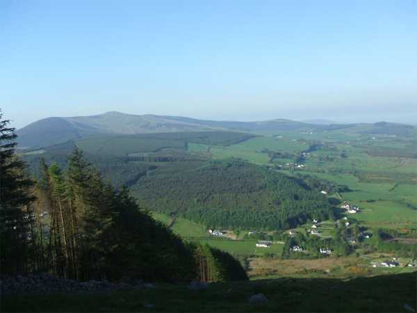
Looking down on the lesser known Wicklow Gap from the northern end of the top of Annagh. Croghan Mountain is to the left. Linkback: mountainviews.ie/summit/609/comment/6354/
Read Less
Read More
Picture: Croghan viewed from the summit of Annagh Hill
csd on Annagh Hill
by csd
27 Apr 2008
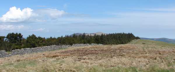
It doesn't seem possible to gain access to Annagh Hill from the east: numerous houses and their large gardens block your way. Instead, I tried an approach from the southwest. Parking at the start of the forest track at B (T07940 66897) (where there's plenty of space), I followed the track to the edge of the forest. It was then a simple matter of handrailing the forest all the way to the summit. The steep slopes give it an almost ridge-like aspect. I was pleasantly surprised by the views from the top on what was a beautiful day. The whole sweep from Lug to the north to Mount Leinster in the south was visible: not bad for a hill of only 454 metres. Recommended. Linkback: mountainviews.ie/summit/609/comment/3068/
Read Less
Read More
Picture: The track to the summit is visible on right
A pleasant hike on a fine June morning
by Colin Murphy
17 Jun 2020
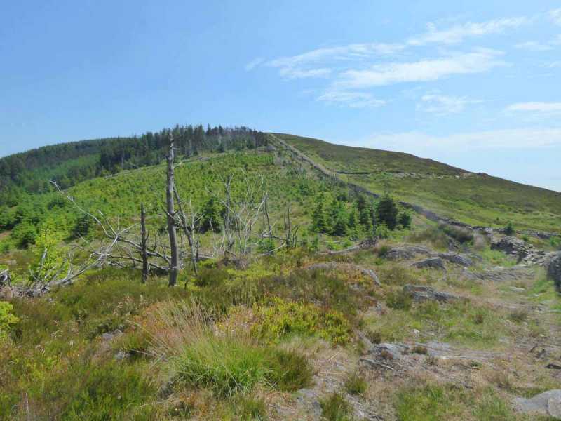
From the east the summit of Annagh is just 1km from the road, but it's steep and I'm a lazy sod so I opted for the gentler approach from B (T07940 66897), which requires about 2.5k's walking up a much gentler incline. I followed the track to its natural end (it becomes very narrow after about 1km) then took off up through a bit of a gap in the trees. After a few minutes I encountered a wall climbing up the hill in a NNW direction and followed this for about 10 minutes up to a good track that runs along the ridge and goes all the way to the top. There are some smallish boulders near the summit and I believe the presence of a small Catholic shrine facing them suggests they were a mass rock back in penal times. But the highest point is a grassy mound a few metres to the east surmounted by a small pile of rocks. Linkback: mountainviews.ie/summit/609/comment/20802/
Read Less
Read More
Picture: Annagh Hill
The Harlequin Annagh
by simon3
25 May 2010
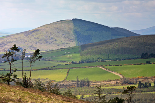
A view of the harlequin Annagh Hill from Slievefoore taken in 2009. In early 2010 the trees on the right were being harvested. Linkback: mountainviews.ie/summit/609/comment/3753/
Read Less
Read More
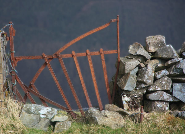
Picture: Gate to the slope.
Gate between slope and ridge.
by simon3
5 Apr 2010
One handy way up Annagh Hill is from the NE from near Clonroe Cross Roads at around A (T1105 6875) where there is a modern dilapidated gate and boggy track leading to a small flattened space. This is all in sight of the steepish but very climbable northern side of the hill with its forest boundary running towards the SW. As of 2010 the trees certainly on the lower slopes of Annagh Hill are being harvested so the Harlequin Annagh will become the Piebald Annagh. This route on Annagh is useful if you are planning to walk Annagh and then Croghan Kinsella since it neatly connects the two.
After climbing the slope you will cross a wall and come to a fairly flattish ridge with views to the coast including Tara Hill and views, where the trees aren't too high, towards the southern Wicklows such as Lugnaquiilia.
The old gate in the wall at the top of the northern slope, shown below, hints of a history of the land and serves to divide the flattish ridge from the steepness down towards the local area, Ballythomas. Linkback: mountainviews.ie/summit/609/comment/4578/
Use of MountainViews is governed by conditions and a privacy policy.
Read general information about the site. Opinions in material here are not necessarily endorsed by MountainViews.
Hillwalking is a risk sport. Information in comments, walks, shared GPS tracks or about starting places may
not be accurate for example as regards safety or access permission. You are responsible for your safety and your permission to walk.
See the credits and list definitions.


 Our Facebook page.