Donation Request 2024
You do not have to be logged in to donate.
DONATE
Members and Supporters, the MountainViews Committee requests your help to meet the costs of the website and of other activities such as insured events or publications.You do not have to be logged in to donate.
Welcome to MountainViews
If you want to use the website often please enrol (quick and free) at top right.
If you want to use the website often please enrol (quick and free) at top right.
Overview

For more map options click on any overview map area or any detail map feature.
Detail Map Features
Find Suggested Walks
Find hill, mountain, island, coastal feature.
Videos
Recent Contributions
 Get Notifications
Get Notifications
Crocknapeast: Long walk up windfarm roads.
 Collaborative entry
Double bag mostly on windfarm tracks.
 Colin Murphy
Mulnanaff: Longish walk up windfarm road.
 Collaborative entry
Good, relatively easy double bag
 Colin Murphy
Binbane NE Top: Simple bag from its neighbouring top.
 Collaborative entry
Binbane: Steepish approach to relatively easy Carn.
 Collaborative entry
Lake District: Dale Head Horseshoe
Crucknaree: Magnificent views!
 paddyhillsbagger
Lake District: Coledale Horseshoe
Dunranhill: Sika deer and sitka spruce
 hibby
hibby
Crocknasharragh: Impressive views on initial ascent.
 Colin Murphy
Longish walk to isolated top
 Colin Murphy
Conditions and Info
Use of MountainViews is governed by conditions and a privacy policy.
Read general information about the site.
Opinions in material here are not necessarily endorsed by MountainViews.
Hillwalking is a risk sport. Information in comments, walks, shared GPS tracks or about starting places may not be accurate for example as regards safety or access permission. You are responsible for your safety and your permission to walk.
See the credits and list definitions.
 Visit our Facebook page.
Video display
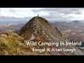
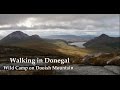
Derryveagh Mountains
Area N: Aghla Subarea
Place count in area: 38,
OSI/LPS Maps: 1, 11, 2, 6
Highest place: Errigal, 751m
Maximum height for area: 751 metres,
Maximum prominence for area: 688 metres,
Places in area Derryveagh Mountains:
Cen: Dooish:Dooish 651.5mDooish SW Top 528mDooish SE Top 553.9mSaggartnadooish 506.4mSaggartnadooish East Top 478.9m
Cen: Errigal:Errigal 751mMackoght 555m
Cen: Glenveagh Upper:Crockfadda 485mCrockfadda East Top 454mCrockballaghgeeha 480mCrockmulroney 430mStaghall Mountain 486mCroaghnasaggart 480mMaumlack 480m
Cen: Lough Keel (Meencorwick):Crockglass 489mAddernymore 416mGrogan More 457mCrocknafarragh 517mCrocknafarragh SE Top 470m
Cen: Slieve Snaght:Crockfadda 529mCrockfadda NE Top 502mCrocknasharragh 495mDrumnalifferny Far NE Top 535mBingorms 578mDrumnalifferny Mountain 596mDrumnalifferny Mountain NE Top 585mSlieve Snaght 678m
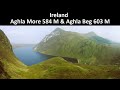
N: Aghla:Aghla Beg 563.9mAghla Beg South Top 602.3mAghla More 581.2mArdloughnabrackbaddy 472.5mCrocknalaragagh 470.6m
N: Muckish:Muckish 667.1mCroaghaderry 222mCrockawama 238mDerryreel 232m
S: Doochary:Croaghleconnell 266m
S: Dungloe:Crovehy 315m
Note: this list of places includes island features such as summits, but not islands as such.
Highest place:
Errigal, 751mPlaces in area Derryveagh Mountains:
Cen: Dooish:
Dooish 651.5mDooish SW Top 528mDooish SE Top 553.9mSaggartnadooish 506.4mSaggartnadooish East Top 478.9mCen: Errigal:
Errigal 751mMackoght 555mCen: Glenveagh Upper:
Crockfadda 485mCrockfadda East Top 454mCrockballaghgeeha 480mCrockmulroney 430mStaghall Mountain 486mCroaghnasaggart 480mMaumlack 480mCen: Lough Keel (Meencorwick):
Crockglass 489mAddernymore 416mGrogan More 457mCrocknafarragh 517mCrocknafarragh SE Top 470mCen: Slieve Snaght:
Crockfadda 529mCrockfadda NE Top 502mCrocknasharragh 495mDrumnalifferny Far NE Top 535mBingorms 578mDrumnalifferny Mountain 596mDrumnalifferny Mountain NE Top 585mSlieve Snaght 678mN: Aghla:
Aghla Beg 563.9mAghla Beg South Top 602.3mAghla More 581.2mArdloughnabrackbaddy 472.5mCrocknalaragagh 470.6mN: Muckish:
Muckish 667.1mCroaghaderry 222mCrockawama 238mDerryreel 232mS: Doochary:
Croaghleconnell 266mS: Dungloe:
Crovehy 315mNote: this list of places includes island features such as summits, but not islands as such.

Bedrock type: Whitish quarztite with pebble beds, (Ards Quartzite Formation)
P.W. Joyce, interprets this name as Ir. eachla or eachlann, 'stable', suggesting it is an example of a mountain named after a feature situated at its foot [INP]. However, Patrick McKay prefers to see the modern form as a re-interpretation of the original name Achla, a form of Aichill, meaning 'a look-out point or prospect' (Dictionary of Ulster Place-Names). Achill Island in Mayo (Ir. Acaill) may well be derived from the same root. An Eachla Bheag is the 383rd highest place in Ireland.
Linkback: https://mountainviews.ie/summit/336/
COMMENTS for Aghla Beg (An Eachla Bheag) 1 2 Next page >>  Follow this place's comments

|
|
|
|
||
| MountainViews.ie, a Hill-walking Website for the island of Ireland. 2400 Summiteers, 1480 Contributors, maintainer of lists: Arderins, Vandeleur-Lynams, Highest Hundred, County Highpoints etc | |||