Cookies.
This website uses cookies, which are small text files that the website puts on your device to facilitate operation. Cookies help us provide a better service to you. They are used to track general user traffic information and to help the website function properly.
Features
Nearby features appear when you click the map.
Declutter tracks on map.
Place Search
Video
X
Pub: by
Derryveagh Mountains Area , N: Aghla Subarea
Feature count in area: 38, all in Donegal, OSI/LPS Maps: 1, 11, 2, 6
Highest Place: Errigal 751m

Starting Places (29) in area Derryveagh Mountains:
Aleahan Lough, Altderry Bridge, An Chúirt Hotel, Astelleen Burn Waterfall, Derryreel Lough, Dunlewy Lough E, Dunlewy Lough Viewing Point, Errigal Hostel, Errigal Parking, Glenveagh Bridge, Glenveagh National Park SW, Glenveigh Castle, Keel Lough N, Losset North, Lough Acrobane Farmhouse, Lough Ascardan, Lough Barra Slipway CP, Lough Barra W, Meenagoppoge Burn Bridge, Mín Uí Bhaoil, Muckish Gap Shrine, Muckish North Access Road, Nabrackbaddy Lough, Procklis Lough, River Barra Bridge NE, River Barra Bridge SW, Sand Lough NE, Sruhancrolee Bridge, Stranamarragh Bridge

Summits & other features in area Derryveagh Mountains:
Cen: Dooish: Dooish 651.5m, Dooish SW Top 528m, Dooish SE Top 553.9m, Saggartnadooish 506.4m, Saggartnadooish East Top 478.9m
Cen: Errigal: Errigal 751m, Mackoght 555m
Cen: Glenveagh Upper: Crockfadda 485m, Crockfadda East Top 454m, Crockballaghgeeha 480m, Crockmulroney 430m, Staghall Mountain 486m, Croaghnasaggart 480m, Maumlack 480m
Cen: Lough Keel (Meencorwick): Crockglass 489m, Addernymore 416m, Grogan More 457m, Crocknafarragh 517m, Crocknafarragh SE Top 470m
Cen: Slieve Snaght: Crockfadda 529m, Crockfadda NE Top 502m, Crocknasharragh 495m, Drumnalifferny Far NE Top 535m, Bingorms 578m, Drumnalifferny Mountain 596m, Drumnalifferny Mountain NE Top 585m, Slieve Snaght 678m
N: Aghla: Aghla Beg 563.9m, Aghla Beg South Top 602.3m, Aghla More 581.2m, Ardloughnabrackbaddy 472.5m, Crocknalaragagh 470.6m
N: Muckish: Muckish 667.1m, Croaghaderry 222m, Crockawama 238m, Derryreel 232m
S: Doochary: Croaghleconnell 266m
S: Dungloe: Crovehy 315m

Note: this list of places may include island features such as summits, but not islands as such.
Rating graphic.
Ardloughnabrackbaddy, 472.5m Hill Ard Loch na mBreac Beadaí A name in Irish,
Place Rating ..
Ir. Ard Loch na mBreac Beadaí [OSI‡], 'height of Loch na mBreac
Beadaí or lake of the tasty trout’
, Donegal County in Ulster province, in no lists, Ard Loch na mBreac Beadaí is the 655th highest place in Ireland.
Grid Reference B95522 24525, OS 1:50k mapsheet 1
Place visited by: 75 members, recently by: Sweeney, Krzysztof_K, miriam, abcd, ilenia, leader1, srr45, annem, Ulsterpooka, thrifleganger, thomas_g, marcel, Kilcoobin, Kilcubbin, eamonoc
I visited this place: NO (You need to be a logged-in member for this.)
Longitude: -8.070879, Latitude: 55.068036, Easting: 195522, Northing: 424526, Prominence: 28m,  Isolation: 0.8km
ITM: 595472 924509
Bedrock type: Whitish quarztite with pebble beds, (Ards Quartzite Formation)
Notes on name: This peak is a small knoll between Lough Nabrackbaddy (Loch na mBreac Beadaí) and Lough Feeane. The name is correctly positioned on Discovery sheet 1, but incorrectly on sheet 2 (on which it should not appear).
  Short or GPS IDs, 6 char: Ardlgh, 10 char: Ardlghnbrc

Linkback: https://mountainviews.ie/summit/538/
Gallery for Ardloughnabrackbaddy (Ard Loch na mBreac Beadaí) and surrounds
No summary yet for this place .
Member Comments for Ardloughnabrackbaddy (Ard Loch na mBreac Beadaí)
Comment create / edit display placeholder

            MountainViews.ie picture about Ardloughnabrackbaddy (<em>Ard Loch na mBreac Beadaí</em>)
Picture: L to R, Aghla Beg, Muckish in the background, Aghla Beg (South) and Ardloughnabrackbaddy is marked
vikinghar on Ardloughnabrackbaddy
by vikinghar 29 Apr 2008
Ardloughnabrackbaddy is a bit of a controversy, so bear with me. First off the name is hard to say. It comes from the Irish meaning “the high brown-trout Lough”. Secondly, OSI sheet 2 gives the name, Ardloughnabrackbaddy, to the highest of the three Sisters (or Aghla’s) and this wonderful and erudite website, which it truly is, calls that particular mountain, “Aghla Beg (South)”, which is actually higher than Aghla Mor. Thirdly, OSI sheet 1, in agreement with this wonderful and erudite website, gives the name Ardloughnabrackbaddy to another height, not 500 yards away from the other Ardloughnabrackbaddy. Lastly (thank goodness, says you), Ardloughnabrackbaddy is not really a distinct mountain, in and of itself. You can see from the map that there is a defined height of 473m, but from the picture, Ardloughnabrackbaddy is completely dwarfed by the mountains and ridges of the main Aghla’s. In fact there are turf hags that are more distinct. Put it this way, if you where at the bottom of the Aghla’s looking up, you would not see it, and if you where on top on the Aghla’s you would not notice it. In walking terms, this is not a mountain that is distinct from its surroundings, and diverting from the walk from Aghla Mor to Aghla Beg (South), or vice versa, it is hardly worth the “bagging”. See the comments for the Aghla’s to get a really good walk in the area around Ardloughnabrackbaddy. Linkback: mountainviews.ie/summit/538/comment/3070/
Read Less
Read More

            MountainViews.ie picture about Ardloughnabrackbaddy (<em>Ard Loch na mBreac Beadaí</em>)
Picture: Walkers making for Ardloughnabrackbaddy (Pt. 473)
A worthwhile diversion
by Harry Goodman 2 Feb 2016
Having noted by vikinghar's comments that this top in walking terms is hardly worth the "bagging" and having also noted at the same time the high rating given to it by members of mv's I thought I should go and have a look for myself and make up my own mind. As I was in the Derryveagh Mts for a walking week-end with my Club and as one of my planned walks was to go from Muckish Gap to Altan Lough over Crocknalaragagh and the Agla's, I decided to include Ardloughnabrackbaddy (Pt 473) as part of my route.
On 1 May 2010 we approached the hill directly from the top of Agla Beg South by descending W with a touch of N to the coll above Lough Feeane A (B95750 24400) and then through a dense patch of peat hags, before climbing gently to the top which is marked by a small cairn. On the day we were there we had fine views N over the coast and lowlands around Falcarragh, across to Tory Island and W over Carn Traonach and Bloody Foreland Hill. Although I had been across Crocnalaragagh and the Aglas a number of times in the past I had never diviated from the usual route SW around Lough Feenane before climbing up to the top of Agla More.
The difference this time was that our climb over Ardloughnabrackbaddy (Pt 473) allowed us to head down SW across the out flow from Lough Feeane B (B95250 24400) and then across a large patch of rock debris to the grassy NW spur. Once there we climbed steeply up to the top before descending SE down the ridge to C (B95500 23100) and then SSW to Altan Lough. We then followed the winding track up to the R251. For anyone not keen on crossing rock debris this can easily be avoided by heading due west from Pt 473 directly to the NW spur of Agla More at D (B94800 24500) and then climb to the top. Having been across Ardloughnabrackbaddy I would commend this short diversion off the usual track between the Aglas as a worthwhile alternative and, at present, "less travelled" route. Linkback: mountainviews.ie/summit/538/comment/4687/
Read Less
Read More

            MountainViews.ie picture about Ardloughnabrackbaddy (<em>Ard Loch na mBreac Beadaí</em>)
Picture: The small cairn on Ardloughnabrackbaddy, framed by Aghla Beg and the other Ardloughnabrackbaddy(?),
More names confusion from our OS friends
by Colin Murphy 13 Jun 2010
Agree with Vikinghar that the OS maps are a mess with regard to the names etc in this area, with Ardloughnabrackbaddy being attributed to two tops, one of which is actually the highest of the three Aghlas (carrying the appendage 'South on MVs). That aside I found this hill lacking in any great interest or astheic, aside from the views it provides. But having said that, it is so easy to bag if your're doing the three Aghlas, you might as well nab this one. You'll be up and down it in fifteen minutes. Linkback: mountainviews.ie/summit/538/comment/5873/
Read Less
Read More

            MountainViews.ie picture about Ardloughnabrackbaddy (<em>Ard Loch na mBreac Beadaí</em>)
Picture: Whirlwind on Lough Ardloughnabrackbaddy
The Good, the Bad and the Aghly!
by kernowclimber 8 Oct 2013
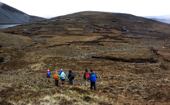
‘You’s not be getting a taxi here at that time’, said the receptionist at Errigal hostel shaking her head, ‘there’s no one who’ll take a fare that time of the morning’. A taxi in Dunlewey at 9.00 am? No chance. But 4.00 am? No problem. Changing our plans, we opted for a round of the Aghlas. The day was cloudy and didn’t hold much promise as we set off up a stony boreen by the R256. Off the track, the terrain of stunted heather and bilberry entangled in spongy sphagnum with shin high tussocks was brutal and I had foolishly forgotten to insert my orthopaedic insoles into my new boots.

Past Lough Moilt we began the viciously steep climb up the scree covered NW ridge of Aghla Beg. The salt laden wind was blowing straight from the Atlantic slowing progress. We paused momentarily to catch our breath and watched as a thin curtain of rain briefly pulsated across the vast expanse of desolate bog below, petering out before it reached us. The endless grey sea merging into dreary russet bog bearing the ancient scars of the slane, and dark clouds galloping across the sky, seemed to herald the coming of winter.

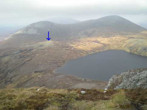
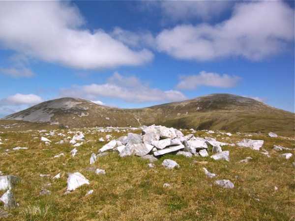
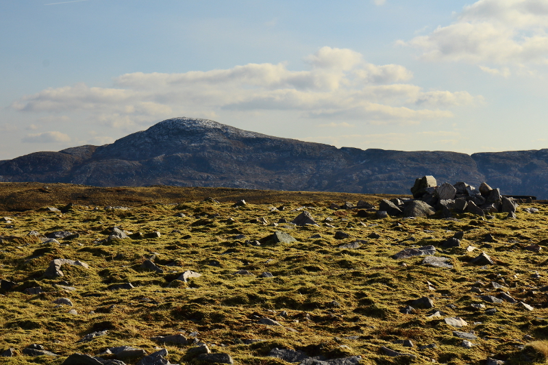
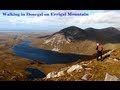
Barely managing to stand upright in the wind, we arrived at the large quartzite summit cairn. Ahead lay the next 3 of our quartet of peaks: Aghla Beg South Top, which is the highest, not Aghla Mor (confused? So was I!) and playing piggy in the middle, the runt of the litter, Ardloughnabrackbaddy, by the lough of the same name. As we descended Aghla Beg South the cloud started to lift, blue sky flashed between the scurrying clouds and the sun broke through illuminating streaks of quartz in the Derryveagh Mountains and whitewashed farmhouses tucked into the folds of the hills, bathing all in a translucence unique to Donegal.

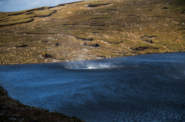
On Aghla Mor’s narrow ridge it was almost impossible to remain upright in the wind roaring like a jet engine up the mountain from Atlan Lough. Believing we’d get some shelter on the leeward side of the hill, we beat a hasty descent over ankle twisting terrain. My feet were by now protesting wildly: agony in the Aghlas! As I paused to rest, a tremendous roar swept up behind me, a force buffeted my left shoulder sending me off balance, and completely upended mcrtchly in front. Invisible until it hit Lough Ardloughnabrackbaddy, the whirlwind began its maniacal dervish dance across the lake, ripping the water into a foaming snarling maelstrom, before dumping it with a strident hiss. I watched spellbound as the surface of the indigo lake was agitated by the wind causing a million malevolent looking inky tentacles to spread beneath is surface. The gusts were so powerful they blew the water off the lake in huge shimmering veils and we had to run the gauntlet to cross the shore without getting drenched.

Ardloughnabrackbaddy bagged, I hobbled back to the car via a traverse round Aghla Beg. The pain in my feet is now forgotten, but the whirlwinds on Lough Ardloughnabrackbaddy are indelibly etched in my memory. Linkback: mountainviews.ie/summit/538/comment/15219/
Read Less
Read More

            MountainViews.ie picture about Ardloughnabrackbaddy (<em>Ard Loch na mBreac Beadaí</em>)
Picture: View towards Dooish from the summit cairn
Longer To Write Than Climb
by Aidy 1 Mar 2016
On the way from Aghla More to Aghla Beg South, it was easy to take in this small summit with a short diversion after rounding the southern side of Lough Fiain. It may be a controversial top, but it is so easy to include, that it would be almost mad not to. It would almost take longer to write than summit. I thought it was worth it for the different perspective it gave on the steep southern shore of Lough Fiain if nothing else. Linkback: mountainviews.ie/summit/538/comment/18449/
Read Less
Read More
EDIT Point of Interest
text
Videos


Recent Contributions
x
Conditions and Info
Use of MountainViews is governed by conditions and a privacy policy.
Read general information about the site.
Opinions in material here are not necessarily endorsed by MountainViews.
Hillwalking is a risk sport. Information in comments, walks, shared GPS tracks or about starting places may not be accurate for example as regards safety or access permission. You are responsible for your safety and your permission to walk.
See the credits and list definitions.

OSi logo
OSNI/LPS logo
Open Street Map
(Various variations used.)
British summit data courtesy:
Database of British & Irish Hills