This website uses cookies, which are small text files that the website puts on your device to facilitate operation. Cookies help us provide a better service to you. They are used to track general user traffic information and to help the website function properly.
Feature count in area: 38, all in Donegal,
OSI/LPS Maps: 1, 11, 2, 6
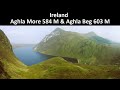
Highest Place: Errigal 751m
Starting Places (29) in area Derryveagh Mountains: Aleahan Lough, Altderry Bridge, An Chúirt Hotel, Astelleen Burn Waterfall, Derryreel Lough, Dunlewy Lough E, Dunlewy Lough Viewing Point, Errigal Hostel, Errigal Parking, Glenveagh Bridge, Glenveagh National Park SW, Glenveigh Castle, Keel Lough N, Losset North, Lough Acrobane Farmhouse, Lough Ascardan, Lough Barra Slipway CP, Lough Barra W, Meenagoppoge Burn Bridge, Mín Uí Bhaoil, Muckish Gap Shrine, Muckish North Access Road, Nabrackbaddy Lough, Procklis Lough, River Barra Bridge NE, River Barra Bridge SW, Sand Lough NE, Sruhancrolee Bridge, Stranamarragh Bridge
Summits & other features in area Derryveagh Mountains: Cen: Dooish: Dooish 651.5m, Dooish SW Top 528m, Dooish SE Top 553.9m, Saggartnadooish 506.4m, Saggartnadooish East Top 478.9m Cen: Errigal: Errigal 751m, Mackoght 555m Cen: Glenveagh Upper: Crockfadda 485m, Crockfadda East Top 454m, Crockballaghgeeha 480m, Crockmulroney 430m, Staghall Mountain 486m, Croaghnasaggart 480m, Maumlack 480m Cen: Lough Keel (Meencorwick): Crockglass 489m, Addernymore 416m, Grogan More 457m, Crocknafarragh 517m, Crocknafarragh SE Top 470m Cen: Slieve Snaght: Crockfadda 529m, Crockfadda NE Top 502m, Crocknasharragh 495m, Drumnalifferny Far NE Top 535m, Bingorms 578m, Drumnalifferny Mountain 596m, Drumnalifferny Mountain NE Top 585m, Slieve Snaght 678m N: Aghla: Aghla Beg 563.9m, Aghla Beg South Top 602.3m, Aghla More 581.2m, Ardloughnabrackbaddy 472.5m, Crocknalaragagh 470.6m N: Muckish: Muckish 667.1m, Croaghaderry 222m, Crockawama 238m, Derryreel 232m S: Doochary: Croaghleconnell 266m S: Dungloe: Crovehy 315m
Note: this list of places may include island features such as summits, but not
islands as such.
Dooish SE Top, 553.9mMountain An Dubhais (mullach thoir theas) A name in Irish,
Place Rating ..
For origin of name, see An Dubhais / Dooish., Donegal County in Ulster province, in Arderin Lists, An Dubhais (mullach thoir theas) is the 412th highest place in Ireland.
Grid Reference B98923 20648,
OS 1:50k mapsheet 6 Place visited by: 91members, recently by: MeabhTiernan, Carolineswalsh, NualaB, paulbrown, nupat, abcd, johncusack, a3642278, annem, srr45, AlanReid, Kilcoobin, Carolyn105, eoghancarton, markmjcampion
I visited this place: NO (You need to be a logged-in member for this.)
(see Saggartnadooish & Dooish for previous parts of walk). Drop of 100m from top of Saggartnadooish over wet ground down to Derrybeg stream before climbing steeply up shoulder of Se Top. I had high expectations here, having seen two eagles wheeling over this plateau two years previously from the castle below in Glenveagh. Despite keping eyes peeled and sitting quietly for a time on the top I did not get my wish. I did bump into my first deer on the climb as they stood intently watching me from the top - when I arrived they were nowhere to be seen. The steep sided valley of Glenveagh and the Lough and visitor centre can be seen from here and there is a tiny cairn. Again excellent views from the top taking in most, if not all of Donegal. I dropped down to col with Dooish which is an area of heavily eroded peat hags and then contoured around the side of dooish towards the distant cairn ontop of Maumlack. I met two further small groups of deer at closer quarters as I made my way back. i dropped down of the plateau, following a stream into the E shore of Croloughan Lough and followed the shore of the Lough and the river exiting at its N end. Followed this back to the road and the carpark at the bottom of Errigal. Linkback: mountainviews.ie/summit/350/comment/1668/
Read Less
Read More
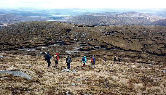
Picture: Dooish SE Top from Dooish
A walk to Dooish SE Top
by Harry Goodman
30 Jul 2020
As part of a May Bank Holiday 2010 week-end walking in the Derryveagh Mountains I planned a route that, in addition to Dooish, would also include Dooish SE Top, Keamnacally overlooking Glenveigh, Saggartnadooish E Top and Saggartnadooish. Apart from Dooish none in the group had been to the other tops. We parked at a layby on the R251 just NE of a road bridge Meenagop (B96944 21823) and made directly up hill to pass through the Deer Fence and then up to the right of Dooish to a rocky grove in the ridge, before turning left and climbing up over rocky humps to the substantial summit cairn. From here the long flat ridge of Dooish SE Top lay below us (see photo). Initially we headed down to the coll and then up to the lower top Pt. 545 before turning left and walking along the flat ridge for some 400 metres to the slightly higher summit at Pt 555 marked by a small cairn. ( For somone not wanting to complete the looped walk over several tops Dooish SE Top could be reached more directly from the ridge without topping out on Dooish.) Once there with the exception of the NW, blocked by the bulk of Dooish, the views are expansive with the Sperrin Mountains clearly seen away to the SE. From the top we then continued our walk due E down and across the Derrybeg Stream to the lesser height of Keamnacally A (C00600 20975) (not a listed mv top) before heading NW along the ridge to Saggartnadooish E Top. (For further details of this route see also my comments on Saggartnadooish E Top) Linkback: mountainviews.ie/summit/350/comment/4719/
Read Less
Read More
Picture: Summit stones
The boggy brother
by Colin Murphy
4 May 2011
See entry for Sagartnadooish for route. Unlike Sagartnadooish to the NE and Dooish itself to the NW, this top is decidedly lacking in boulders but more resembles a boggy Wicklow top. Pic shows the small pile of stones indicating the summit. Linkback: mountainviews.ie/summit/350/comment/6338/
Read Less
Read More
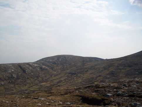
Picture: Dooish SE Top from Saggartnadooish
eflanaga on Dooish
by eflanaga
30 Jul 2020
(See Dooish/Saggartnadooish for previous legs of route). A fairly simple & sedate descent south from the summit area of Saggartnadooish brought me to the valley floor. In keeping with the previous two legs of the walk the terrain was a mixture of rocks, small peat hags and long & wiry mountain grass. Shortly after reaching the valley floor I crossed the western end of Derrybeg stream before starting my ascent of the mountain via its northern slope. Tiredness, most probably due to the intense heat, was taking its toll and I found the steep ascent more difficult than it should otherwise have been. Nevertheless, I reached the top without mishap. The fairly flat summit area has little to distinguish it and again the true summit is not immediately obvious. There is a mini cairn (3 stones) on what appears to be one of the ‘heights’ and GPS reading here was 553m, two metres short of OS map’s suggested height. From the summit I took a bearing of 171degrees to take me to the track below Astellan waterfall. This descent from Dooish SE Top is well over 2K. I reached the waterfall after what appeared to be an interminable length of time – again heat exhaustion possibly played a part. There wasn’t a great deal of water cascading down the falls but I got the idea that it might be something special in wetter weather. I was going to trek across and drop into Astellan Burn but decided to risk the descent to the right (east) of the actual waterfall. This is extremely steep, not for the feint hearted and requires a degree of scrambling (minus the rocks) and great care to be taken. Had to drop about 3 metres at one stage when footholds ran out. Despite this managed to reach the bottom without mishap. Crossed a meadow and found a shallow part of Glenbeagh River just west of Sturricknagower IB (B99502 18426) – 90m, making for building alongside the trail, which I presume is a Bothy (maybe not?). From here it is a pleasant walk of around 3.5 K, flat at first then a climb of about 190m back to the starting point. The entire route was just over 16.2K, tiring in the heat, but a thoroughly enjoyable walk with wonderful scenery – recommended! Linkback: mountainviews.ie/summit/350/comment/2344/
Use of MountainViews is governed by conditions and a privacy policy.
Read general information about the site. Opinions in material here are not necessarily endorsed by MountainViews.
Hillwalking is a risk sport. Information in comments, walks, shared GPS tracks or about starting places may
not be accurate for example as regards safety or access permission. You are responsible for your safety and your permission to walk.
See the credits and list definitions.


 Add a Place Comment for Dooish SE Top, An Dubhais (mullach thoir theas)


 Our Facebook page.