If you want to use the website often please enrol (quick and free) at top right.

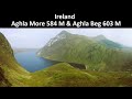
Errigal 751m, Dooish 651.5m, Aghla Beg South Top 602.3m, Aghla More 581.2m, Aghla Beg 563.9m, Mackoght 555m, Dooish SW Top 528m, Staghall Mountain 486m, Croaghnasaggart 480m, Maumlack 480m,
 Get Notifications
A visit to Tievummera via its South East spur.
 simon3
Ben Creggan: Craggy summit with long descending spur to the east.
 Collaborative entry
Teevenacroaghy: Misty Achill.
 simon3
Dorinish More: Shapely islands in Clew Bay, Co Mayo.
 simon3
Crott Mountain: Quiet Arderin at the east end of the Croagh Patrick ridge.
 Collaborative entry
Teevenacroaghy: A heathery ridge bump with good views.
 Collaborative entry
Teevenacroaghy: A clear day on the Hill
 three5four0
Madeira: From Pico Arieiro to Pico Ruivo
Madeira: Coastal/Cliff walk to the Eastern Edge
Madeira: Descent from Monte to Funchal
Hag's Tooth: This might hurt
 No1Grumbler
Galtymore: Dawn on Galtymore
 DeirdreM
Use of MountainViews is governed by conditions and a privacy policy.
Read general information about the site.
Opinions in material here are not necessarily endorsed by MountainViews.
Hillwalking is a risk sport. Information in comments, walks, shared GPS tracks or about starting places may not be accurate for example as regards safety or access permission. You are responsible for your safety and your permission to walk.
See the credits and list definitions.
 Visit our Facebook page.
 Length: 15.6km, Creator time taken: 8h51m, Ascent: 871m,
Descent: 867m
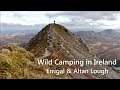
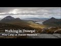
Places: Start at B9356625615, An Earagail, Mac Uchta, end at Start
Logged as completed by 2

A small apology as my GPS was not on for the first part of the walk, though hopefully the direction here will be of aid. Follow the road south and at a bend climb the gate to take an old bog road heading straight for Errigal looming in the distance. This can be pretty wet and characterised as more of a stream.
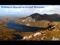
Quite a bit of walking with lovely views across to Altan Lough and Aghla More before the bog road eventually peters out. A clear line of approach beckons over a couple of smaller tops, with pretty good going and stunning views across Altan Lough from good height. Reach the scree skirted northern flank of Errigal and pause for breath before a steep and unforgiving walk/scramble. Again pauses on the way take some of that breath that was stored up at the bottom!
Reach an area of rocky outcrops and follow a well defined path that contours to the western side of the mountain and rises to a spectacular rock window, after which a steep walk/scramble brings the summit. On this occasion a group of French were already at the summit and were i think a bit surprised to see me appear!
A very strong north westerly was blowing and made standing on top a challenge but the air from that direction provided stunning views on a 360 degree panorama, with the showers it was pushing through giving the odd rainbow. Having taken in the view descent was by the usual route to the south on the well trodden path.
Headed for Macknoght and desended steeply and rose gently to Beaghy and then steeply down to the wonderful sight of Lough Altan and the abandoned farm. Crossing the river over the large stepping stones and relaxing at the grassy shores of the Lough, with water gently lapping the sandy beach. The only other company was a small number of sheep - a wondrous camp site if ever there was one!
Continued along the shore of Altan Lough below the slopes of Aghla More. A fairly good sheep trail hugs the shore, with just a few wetter bits. This does change nearer to the northern end of the Lough where the ground was much wetter and is grazed by cows which made the ground quite difficult.
At the northern end of the Lough, the Tullaghobegly River needs to be crossed which was a bit tricky - with poles probably would have been easy, so decided on a dash and splash which worked well with boots remaining dry inside. This brings a track - this had a private land sign off to the side of the track which i took as meaning to stay on the track. This took me back to the minor road not many metres away from the lough and my car. Here though i did notice another sign saying the track was private. Not sure if this would lead to any problems for walkers using it though?
A long day for me as was taking some video, so ignore the stopped time in the track. Video can be found on Youtube link below. A very quite approach and return, only meeting others on a short stretch on Errigal. A good challenge on the northern slopes and something that bit different.
http://www.youtube.com/watch?v=cvH0QJjLeOg&feature=share&list=UUMhmcA3Bwe1X4niYiswhU0A
NOTE: ALL information such as Ascent, Length and Creator time taken etc should be regarded as approximate. The creator's comments are opinions and may not be accurate or still correct.
Your time to complete will depend on your speed plus break time and your mode of transport. For walkers: Naismith's rule, an approximate though often inaccurate estimate, suggests a time of 4h 34m + time stopped for breaks
NOTE: It is up to you to ensure that your route is appropriate for you and your party to follow bearing in mind all factors such as safety, weather conditions, experience and access permission.
* Note: A GPS Height in the elevation profile is sourced from the device that recorded the track. An "SRTM" height is derived from a model of elevations for parts of the earth. More detail![]()
|
|
|
||
| MountainViews.ie, a Hill-walking Website for the island of Ireland. 2400 Summiteers, 1480 Contributors, maintainer of lists: Arderins, Vandeleur-Lynams, Highest Hundred, County Highpoints etc | |||