This website uses cookies, which are small text files that the website puts on your device to facilitate operation. Cookies help us provide a better service to you. They are used to track general user traffic information and to help the website function properly.
Feature count in area: 38, all in Donegal,
OSI/LPS Maps: 1, 11, 2, 6
Highest Place: Errigal 751m
Starting Places (29) in area Derryveagh Mountains: Aleahan Lough, Altderry Bridge, An Chúirt Hotel, Astelleen Burn Waterfall, Derryreel Lough, Dunlewy Lough E, Dunlewy Lough Viewing Point, Errigal Hostel, Errigal Parking, Glenveagh Bridge, Glenveagh National Park SW, Glenveigh Castle, Keel Lough N, Losset North, Lough Acrobane Farmhouse, Lough Ascardan, Lough Barra Slipway CP, Lough Barra W, Meenagoppoge Burn Bridge, Mín Uí Bhaoil, Muckish Gap Shrine, Muckish North Access Road, Nabrackbaddy Lough, Procklis Lough, River Barra Bridge NE, River Barra Bridge SW, Sand Lough NE, Sruhancrolee Bridge, Stranamarragh Bridge
Summits & other features in area Derryveagh Mountains: Cen: Dooish: Dooish 651.5m, Dooish SW Top 528m, Dooish SE Top 553.9m, Saggartnadooish 506.4m, Saggartnadooish East Top 478.9m Cen: Errigal: Errigal 751m, Mackoght 555m Cen: Glenveagh Upper: Crockfadda 485m, Crockfadda East Top 454m, Crockballaghgeeha 480m, Crockmulroney 430m, Staghall Mountain 486m, Croaghnasaggart 480m, Maumlack 480m Cen: Lough Keel (Meencorwick): Crockglass 489m, Addernymore 416m, Grogan More 457m, Crocknafarragh 517m, Crocknafarragh SE Top 470m Cen: Slieve Snaght: Crockfadda 529m, Crockfadda NE Top 502m, Crocknasharragh 495m, Drumnalifferny Far NE Top 535m, Bingorms 578m, Drumnalifferny Mountain 596m, Drumnalifferny Mountain NE Top 585m, Slieve Snaght 678m N: Aghla: Aghla Beg 563.9m, Aghla Beg South Top 602.3m, Aghla More 581.2m, Ardloughnabrackbaddy 472.5m, Crocknalaragagh 470.6m N: Muckish: Muckish 667.1m, Croaghaderry 222m, Crockawama 238m, Derryreel 232m S: Doochary: Croaghleconnell 266m S: Dungloe: Crovehy 315m
Note: this list of places may include island features such as summits, but not
islands as such.
Saggartnadooish, 506.4mMountain Sagart na Dubhaise A name in Irish,
Place Rating ..
(Ir. Sagart na Dubhaise [DUPN], 'chaplain/attendant of Dooish'), Donegal County in Ulster province, in Arderin Lists, Sagart na Dubhaise is the 551st highest place in Ireland.
Grid Reference B99124 21674,
OS 1:50k mapsheet 6 Place visited by: 79members, recently by: Carolineswalsh, NualaB, nupat, abcd, Cecil1976, johncusack, a3642278, annem, Grumbler, srr45, AlanReid, wintersmick, Kilcoobin, padstowe, upper
I visited this place: NO (You need to be a logged-in member for this.)
Longitude: -8.014484, Latitude: 55.042446, Easting: 199124, Northing: 421675,
Prominence: 61.4m, Isolation: 0.9km ITM: 599074 921658 Bedrock type: Coarse biotite granite & granodiorite, (Main Donegal Granite) Notes on name: This is a subsidiary peak of Dooish and the name is based on this peak being viewed as an attendant to its higher master.
Short or GPS IDs, 6 char: Sgrtnd, 10 char: Sgrtndsh Linkback: https://mountainviews.ie/summit/454/
Gallery for Saggartnadooish (Sagart na Dubhaise) and surrounds
Summary
for Saggartnadooish (Sagart na Dubhaise):
Approach from the North West
Summary created by simon3
2011-05-05 14:16:14
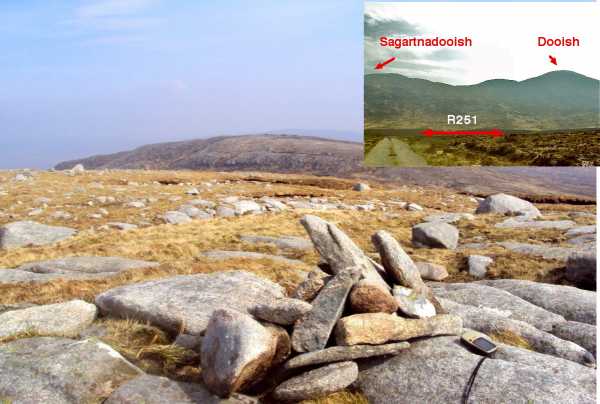
Picture: Summit high point with starting point inset.
There is a large space to park on the R251 at approx A (B980 226), although it leaves your car quite exposed (to vandals/thieves etc). Alternatively drive a little along the track indicated on the map to B (B983 228) where there is space for one car. This spot has unfortunately been used in the past to dump the odd mattress or fridge, but your car cannot be seen from the road. Head directly across the boggy terrain towards the SE, (clambering with difficulty over the deer fence), and then climb up one of the very steep gullies - the one to the right is probably the easier at point C (B993 222) . After this muscle-wrecker, it is about 350m to the summit. Several possibilities for the actual top seem to present themselves, particularly a giant, flat topped boulder, but after scouting around a small pile of stones can be seen which appears to be the highest point. From there you can choose to retrace your steps or continue on to Dooish SE Top and then Dooish, descending through the valley to the NE of Dooish, although be warned the terrain here is in parts steep, very uneven and speckled with boulders.
(see Dooish for previous part of walk). There is a drop of some 200m down from the summit of Dooish to reach Lough Aleahan which lies in the col before Saggartnadooish. This rocks above the lough are a beautiful place to stop and spend some time eating lunch, with waters of the lough lapping gently in a cold N breeze. The whole plateau reminds me very much of the Bluestacks with its water, rock, bog and isolation combining to give a rugged but captivating sense to the walker. It is a short and undemanding climb to the summit beyound the Lough. The top has several large boulders perched strikingly on thier own. There are fantastic views blocked only by the bulk of Dooish to the SW - in particular across to the Aglas and Muckish. I dropped down S into the valley for the climb up to the SE Top of Dooish (see for final part of walk). Linkback: mountainviews.ie/summit/454/comment/1667/
Read Less
Read More
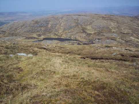
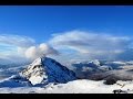
Picture: View across to the Aglas from near the top off Saggartnadooish.
Saggartnadooish
by Harry Goodman
13 May 2010
I climbed Saggartnadooish on 2 May 2010 as the last top in a round which had included Dooish, Dooish SE Top and Saggartnadooish E Top. From the top of Saggartnadooish E Top we headed down to the coll below Saggartnadooish D (B99700 21600) before climbing up the rocky slope to the flat stony top. Once there the highest point was not immediately recognisable and a number of rocky prominences could well vie for that distinction. So once there walk around, as we did and decide for yourself ! or simply stick to the MV co-ordinates. The views from this top are only obstructed to the SW by the bulk of Dooish otherwise you can see across to the Aglas and Muckish, N to Innishowen, NE to the Sperrins and S over Glenveigh. On leaving the summit we went down SW to cross the outlet stream from the N of Lough Aleahan E (B98800 21600) and then NW down the hillside, Initially we went through and around some rocky outcrops, before continuing down over grass and some heather to the Deer Fence and then the R251 and our parking spot Meenagop (B96944 21823). For details of the full circuit see also my comments on Dooish SE Top and Saggartnadooish E Top. Clearly for anyone interested in only climbing Saggartnadooish the above route could be used for a quick climb up and down the hill., Linkback: mountainviews.ie/summit/454/comment/4722/
Read Less
Read More
Picture: Sagartnadooish & Lough Aleahan from Dooish
eflanaga on Saggartnadooish
by eflanaga
12 May 2006
Saggartnadoosih (See Dooish for first part of walk). From Dooish summit it is a fairly long but relatively easy drop over rocky & grass covered terrain on the slopes with small peat hags to be negotiated when you reach the valley floor, more or less parallel with Lough Aleahan. Took route to right of loch. Fairly short climb to summit area. Here it is difficult to discern the true summit. In the end I took two readings about 25 metres apart at IF (B99110 21700) & IG (B99133 21664) - and came up with the same height 508m – seven more than OS map suggests. As with Dooish the views from the summit area were quite awesome in the afternoon sunshine which helped the countryside present itself in all its splendour. Although Dooish and it’s southeast top do block scenery to the south/southwest. My next target was the aforementioned Southeast Top which I had decided to leave until I turned for home after Saggartnadooish. Linkback: mountainviews.ie/summit/454/comment/2343/
Use of MountainViews is governed by conditions and a privacy policy.
Read general information about the site. Opinions in material here are not necessarily endorsed by MountainViews.
Hillwalking is a risk sport. Information in comments, walks, shared GPS tracks or about starting places may
not be accurate for example as regards safety or access permission. You are responsible for your safety and your permission to walk.
See the credits and list definitions.


 Our Facebook page.