Donation Request 2024

DONATE
Members and Supporters, the MountainViews Committee requests your help to meet the costs of the website and of other activities such as insured events or publications.
You do not have to be logged in to donate.
Features
Nearby features appear when you click the map.
Declutter tracks on map.
Place Search
Video
X
Pub: by
Derryveagh Mountains Area , S: Dungloe Subarea
Feature count in area: 38, all in Donegal, OSI/LPS Maps: 1, 11, 2, 6
Highest Place: Errigal 751m

Starting Places (29) in area Derryveagh Mountains:
Aleahan Lough, Altderry Bridge, An Chúirt Hotel, Astelleen Burn Waterfall, Derryreel Lough, Dunlewy Lough E, Dunlewy Lough Viewing Point, Errigal Hostel, Errigal Parking, Glenveagh Bridge, Glenveagh National Park SW, Glenveigh Castle, Keel Lough N, Losset North, Lough Acrobane Farmhouse, Lough Ascardan, Lough Barra Slipway CP, Lough Barra W, Meenagoppoge Burn Bridge, Mín Uí Bhaoil, Muckish Gap Shrine, Muckish North Access Road, Nabrackbaddy Lough, Procklis Lough, River Barra Bridge NE, River Barra Bridge SW, Sand Lough NE, Sruhancrolee Bridge, Stranamarragh Bridge

Summits & other features in area Derryveagh Mountains:
Cen: Dooish: Dooish 651.5m, Dooish SW Top 528m, Dooish SE Top 553.9m, Saggartnadooish 506.4m, Saggartnadooish East Top 478.9m
Cen: Errigal: Errigal 751m, Mackoght 555m
Cen: Glenveagh Upper: Crockfadda 485m, Crockfadda East Top 454m, Crockballaghgeeha 480m, Crockmulroney 430m, Staghall Mountain 486m, Croaghnasaggart 480m, Maumlack 480m
Cen: Lough Keel (Meencorwick): Crockglass 489m, Addernymore 416m, Grogan More 457m, Crocknafarragh 517m, Crocknafarragh SE Top 470m
Cen: Slieve Snaght: Crockfadda 529m, Crockfadda NE Top 502m, Crocknasharragh 495m, Drumnalifferny Far NE Top 535m, Bingorms 578m, Drumnalifferny Mountain 596m, Drumnalifferny Mountain NE Top 585m, Slieve Snaght 678m
N: Aghla: Aghla Beg 563.9m, Aghla Beg South Top 602.3m, Aghla More 581.2m, Ardloughnabrackbaddy 472.5m, Crocknalaragagh 470.6m
N: Muckish: Muckish 667.1m, Croaghaderry 222m, Crockawama 238m, Derryreel 232m
S: Doochary: Croaghleconnell 266m
S: Dungloe: Crovehy 315m

Note: this list of places may include island features such as summits, but not islands as such.
Rating graphic.
Crovehy, 315m Hill Cró Bheithe A name in Irish,
Place Rating ..
(Ir. Cró Bheithe [OSI], 'hollow of birch'), Donegal County in Ulster province, in Binnion Lists, Cró Bheithe is the 1125th highest place in Ireland. Cró Bheithe is the most westerly summit and also the second most southerly in the Derryveagh Mountains area.
Grid Reference B82800 11400, OS 1:50k mapsheet 1
Place visited by: 8 members, recently by: Fergalh, AntrimRambler, chalky, Garmin, paddyhillsbagger, Harry Goodman, ahendroff, hgboyle
I visited this place: NO (You need to be a logged-in member for this.)
Longitude: -8.269215, Latitude: 54.949857, Easting: 182800, Northing: 411400, Prominence: 180m,  Isolation: 5.8km
ITM: 582753 911386
Bedrock type: Coarse grained monzogranite to tonalite, (Thorr Granite)
Notes on name: This is one of a number of Donegal hill names in which the element cró (which normally means 'a hollow' or 'a sheep-pen') has apparently become confused with cruach ('stack').
  Short or GPS IDs, 6 char: Crvhy, 10 char: Crovehy

Linkback: https://mountainviews.ie/summit/937/
Gallery for Crovehy (Cró Bheithe) and surrounds
Summary for Crovehy (Cró Bheithe): A short scenic walk.
Summary created by Harry Goodman 2011-11-03 16:26:21
            MountainViews.ie picture about Crovehy (<em>Cró Bheithe</em>)
Picture: Looking SW. High point is small mound immediately left of the boulder.
From Dunglow take the N56 S and then go left (E) on to the R252. At A (B812 091) (opposite the west end of L. Sallagh), go left on to a minor road and follow along to B (B834 100). There is room to park near a metal gate with a sign on it advising of access to a walking route. Once through the gate follow the track N heading for a small col high up on the ridge straight ahead. Once the track ends continue up in the same direction over a couple of grass covered boggy areas to gain the col C (B83157 11307). A short distance along D (B83117 11475) go left (NW) and follow along a short way to L. Doo E (B83072 11599). Go up steeply SW to the summit. The stone cairn is not the high point. The top is a peatty mound beside a large boulder F (B82791 11423). Return by way of ascent. Total distance 4.25k easily covered in under two hours. To shorten the route, at G (G (B832 114)) go left (W) up the slope to the top.
Linkback: mountainviews.ie/summit/937/comment/5696/
Member Comments for Crovehy (Cró Bheithe)
Comment create / edit display placeholder

            MountainViews.ie picture about Crovehy (<em>Cró Bheithe</em>)
Picture: View north over L.Doo from Crovehy
Well worth a visit.
by Harry Goodman 3 Nov 2011
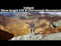
On Sun. 30 Oct 2011, I started my walk up to Cro Bheithe (Crovhey) at B (B834 100). Access was through a metal gate with a sign for a waymarked route. This track is used to link two sections of the Sli Dhun na nGall looped walks (Sli na Finne and Sli na Rossan). The initial grass covered track which runs more or less due N, soon gave way to a much rougher, stoney one which continued along side a stream for about 1k. As I walked along I could clearly see straight ahead a small col high up on the hillside. Where I started to climb up towards the col the track disappeared into a grass covered boggy area which then shelved upwards a couple of times before reaching its high point at C (B83157 11307). Once there I found the ground somewhat firmer by keeping to the left edge of the col. A short distance further along where the ground started to drop away N, at 
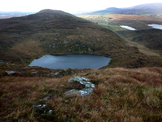
D (B83117 11475), I swung left NW a short distance to Lough Doo 
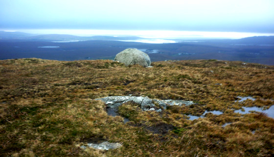
E (B83072 11599), a small mountain tarn and an excellent spot at which to have a snack.. From the lough I turned up left (SW) for a steep but short climb to the top of the hill. Although there is a well made stone cairn it is not on the high point of the hill. This appears to me to be a small peaty mound a metre or so out from a large boulder 30/40m N of the cairn at F (B82791 11423). Views from the top were quite extensive with the long flattish ridge of the Slievetooey Massif clearly seen to the SW and the Bluestacks more or less due S. NE I could make out the long line of the Grogan More, Crocknafarragh, Adernymore ridge but unfortunately the tops were cloud covered. I returned by way of ascent. Clearly the top could be reached by going up directly NW from around G (B832 114) but, unless the walker is in a hurry to get up and down, this has the disadvantage that L Doo would not be included. This is undoubedly a small hill well worth the visit. It can be climbed in less than two hours, with little effort, and is a total of 4.25k out and back. The fact that no one had commented on it and that only two mv members had climbed it made me curious to go and see for myself. I am very glad I did. Given the relaive short distance of the route it could easily be included with a walk on the same day to one or more of the other small hills in the area eg Croaghegly. Linkback: mountainviews.ie/summit/937/comment/6608/
Read Less
Read More
EDIT Point of Interest
text
Videos


Recent Contributions
x
Conditions and Info
Use of MountainViews is governed by conditions and a privacy policy.
Read general information about the site.
Opinions in material here are not necessarily endorsed by MountainViews.
Hillwalking is a risk sport. Information in comments, walks, shared GPS tracks or about starting places may not be accurate for example as regards safety or access permission. You are responsible for your safety and your permission to walk.
See the credits and list definitions.

OSi logo
OSNI/LPS logo
Open Street Map
(Various variations used.)
British summit data courtesy:
Database of British & Irish Hills