Donation Request 2024

DONATE
Members and Supporters, the MountainViews Committee requests your help to meet the costs of the website and of other activities such as insured events or publications.
You do not have to be logged in to donate.
Features
Nearby features appear when you click the map.
Declutter tracks on map.
Place Search
Video
X
Pub: by
Derryveagh Mountains Area , Cen: Lough Keel (Meencorwick) Subarea
Feature count in area: 38, all in Donegal, OSI/LPS Maps: 1, 11, 2, 6
Highest Place: Errigal 751m

Starting Places (29) in area Derryveagh Mountains:
Aleahan Lough, Altderry Bridge, An Chúirt Hotel, Astelleen Burn Waterfall, Derryreel Lough, Dunlewy Lough E, Dunlewy Lough Viewing Point, Errigal Hostel, Errigal Parking, Glenveagh Bridge, Glenveagh National Park SW, Glenveigh Castle, Keel Lough N, Losset North, Lough Acrobane Farmhouse, Lough Ascardan, Lough Barra Slipway CP, Lough Barra W, Meenagoppoge Burn Bridge, Mín Uí Bhaoil, Muckish Gap Shrine, Muckish North Access Road, Nabrackbaddy Lough, Procklis Lough, River Barra Bridge NE, River Barra Bridge SW, Sand Lough NE, Sruhancrolee Bridge, Stranamarragh Bridge

Summits & other features in area Derryveagh Mountains:
Cen: Dooish: Dooish 651.5m, Dooish SW Top 528m, Dooish SE Top 553.9m, Saggartnadooish 506.4m, Saggartnadooish East Top 478.9m
Cen: Errigal: Errigal 751m, Mackoght 555m
Cen: Glenveagh Upper: Crockfadda 485m, Crockfadda East Top 454m, Crockballaghgeeha 480m, Crockmulroney 430m, Staghall Mountain 486m, Croaghnasaggart 480m, Maumlack 480m
Cen: Lough Keel (Meencorwick): Crockglass 489m, Addernymore 416m, Grogan More 457m, Crocknafarragh 517m, Crocknafarragh SE Top 470m
Cen: Slieve Snaght: Crockfadda 529m, Crockfadda NE Top 502m, Crocknasharragh 495m, Drumnalifferny Far NE Top 535m, Bingorms 578m, Drumnalifferny Mountain 596m, Drumnalifferny Mountain NE Top 585m, Slieve Snaght 678m
N: Aghla: Aghla Beg 563.9m, Aghla Beg South Top 602.3m, Aghla More 581.2m, Ardloughnabrackbaddy 472.5m, Crocknalaragagh 470.6m
N: Muckish: Muckish 667.1m, Croaghaderry 222m, Crockawama 238m, Derryreel 232m
S: Doochary: Croaghleconnell 266m
S: Dungloe: Crovehy 315m

Note: this list of places may include island features such as summits, but not islands as such.
Rating graphic.
Crocknafarragh, 517m Mountain Cnoc na bhFaircheach A name in Irish,
Place Rating ..
(Ir. Cnoc na bhFaircheach [OSI], 'hill of the [obscure element]'), Donegal County in Ulster province, in Arderin Lists, Cnoc na bhFaircheach is the 516th highest place in Ireland.
Grid Reference B87809 16754, OS 1:50k mapsheet 1
Place visited by: 52 members, recently by: kernowclimber, mcrtchly, dodser, annem, srr45, AlanReid, Lucky1, eamonoc, Ulsterpooka, ilenia, paulbrown, Grumbler, Lauranna, Fergalh, finkey86
I visited this place: NO (You need to be a logged-in member for this.)
Longitude: -8.191272, Latitude: 54.998124, Easting: 187809, Northing: 416754, Prominence: 172m,  Isolation: 0.7km
ITM: 587761 916742
Bedrock type: Whitish quarztite with pebble beds, (Ards Quartzite Formation)
Notes on name: This is the highest peak on the ridge between Dún Lúiche / Dunlewy and Loch an Iúir / Loughanure. The second element in this name is unclear. In the Ordnance Survey Name Book John O’Donovan recorded two possibilities: ‘hill of thunder’ or ‘hill of the lofts’.
  Short or GPS IDs, 6 char: Crcknf, 10 char: Crcknfrgh

Linkback: https://mountainviews.ie/summit/418/
Gallery for Crocknafarragh (Cnoc na bhFaircheach) and surrounds
Summary for Crocknafarragh (Cnoc na bhFaircheach): A panorama of NW highlights.
Summary created by Harry Goodman 2011-11-17 08:06:20
            MountainViews.ie picture about Crocknafarragh (<em>Cnoc na bhFaircheach</em>)
Picture: View NE from Crocknafarragh
The main disadvantage in climbing this hill is it's relative isolation, making it a top best climbed as part of a greater circuit involving other hills ( Grogan More, Crocknafarragh SE Top, Crockglass). For a direct ascent park off road at Keel L (B846 167) and walk SE around the N side of L. Caol to it's end at A (B850 163). Go initially NE up the line of a stream and then up the open hillside to Pt. 409 at B (B861 166) and then continue up ENE to Pt. 503 at C (B874 168). It is then a short drop down SE past tiny Mullincrick Lough (on right) and then an equally short walk up to the summit cairn. (While there, it is an easy walk of less than 30 mins out and back to bag the SE Top. Walk down SE to a col and then up over Pt. 463 to a small ring contour (470m) where a small cairn marks the top of Crocknafarragh SE Top on a surface so flat that a number of rocks could vie for such a distinction! In all a distance of about 700m with minimal assent.) Crocknafarragh is an excellent spot just to sit and take in the beautiful scenry of much of NW Donegal.
Linkback: mountainviews.ie/summit/418/comment/5177/
Member Comments for Crocknafarragh (Cnoc na bhFaircheach)
Comment create / edit display placeholder

            MountainViews.ie picture about Crocknafarragh (<em>Cnoc na bhFaircheach</em>)
Picture: Looking across to Errigal from Crocknafarragh summit
A commanding viewpoint
by Harry Goodman 13 Aug 2010
My approach to this hill was from Grogan More as the second top to be visited in a five top round on 10 August 2010. Initially I dropped down to a broad boggy coll which was extensively coverd by peat hags. However having noted eflanga's comment that this might be a problem area in wetter weather and having also noted its extent from my view point on Grogan More, with gaiters in place, I strode purposefully on, in and out, up and over, slipping and sliding for what was the only real setback on grand hill circuit. However I was soon on much firmer ground and even some rock on my approach up to Crocknafarragh. My first objective was the rocky top of Pt 503 at D (B87376 16842) for views down to tiny Mullincrick L before a short drop down to a coll and an equally short walk up to the summit cairn at 517m the highest point of my round.This proved to be a beautiful spot to simply sit and take in the beautiful scenery. Best of all it provided me with a platform to go on and visit three other tops not previously commented on in MV's, Crocknafarragh SE Top, only fifteen minutes away and the more distant Crockglass and Addernymore. ( For continuation of this route see my comments on Crocknafarragh SE Top). If the walk is to be terminated at this point return to Pt 503 and then go WSW down the ridge over Pt 409 B (B861 166) and then down to the N end of L Caol E (B845 169) and the road. Turn right and follow back to the car park. Linkback: mountainviews.ie/summit/418/comment/6009/
Read Less
Read More

            MountainViews.ie picture about Crocknafarragh (<em>Cnoc na bhFaircheach</em>)
Picture: Looking over summit cairn towards Croaghgorms
eflanaga on Crocknafarragh
by eflanaga 30 May 2006
Climbed 29-05-06. The limited attention given to Crocknalarragh ( ? Crocknafarragh on OS map) over the course of this website’s lifetime is understandable given its relative isolation from the more alluring and illustrious neighbours in the vicinity. I planned a circuit to take in the two minor Grogan’s so as to avoid a linear route. The starting point for the walk was at I MínBhil (B83874 18575) (St Patrick’s Church). As you enter Croithlí (Crolly) take first left after filling station and before bridge/pub. Pass a quarry (left) on this narrow (waymarked) road before rounding a corner where you will see the church which is painted green. There is ample parking opposite. About 10 metres past end of the car park there is a track rising up on the left past small ruin. Take track, leaving it after about 120 metres & make for obvious gap in ridge. Here a fairly well worn path alongside stream will take you up onto height. Took bearing of 120SW up and over heather covered slope. Going relatively easy following sheep tracks. Emerged on height about 100m north of Loch Nabuckan. Decided to veer off course a little further north so as to approach Grogan More summit along ridge. Cairn at IF (B85612 18463) and summit (OS) another 200m further on at IG (B85708 18248). Most of the route’s climbing is taken care of by this stage. Was going to detour to Grogan Beg but it didn’t appear to be particularly significant so instead took a bearing of 136 SE to Spot Ht 503, initially dropping onto broad col littered with peat hags. Negotiation of these was not too difficult although in wetter weather the detour to Grogan Beg may be advisable. Climb to spot height 503 IH (B87396 16867) is easy. A short drop passing north of Loch Mullincrick and an equally short climb brings you to summit cairn (GPS reading 520m) a few hundred metres to the east. Wonderful views all around, particularly north-east to Errigal over Glentornan & Dunlewey loughs. Return route took me back past Spot Ht 503 then a bearing of 266W to Spot Ht 409 followed by 276WNW, dropping into deep burn and crossing stream after about 800m before joining lane at Loch Caol (reservoir). Pleasant walk along lane to car park. 3.5 hours total. While, aesthetically, Crocknafarragh doesn’t have a lot going for it I enjoyed this walk/route although probably best tackled in reasonably dry weather, particularly if negotiating the peat hag strewn col. Linkback: mountainviews.ie/summit/418/comment/2356/
Read Less
Read More

            MountainViews.ie picture about Crocknafarragh (<em>Cnoc na bhFaircheach</em>)
Picture: Crocknafarragh (R), Slieve Snaght (back) and Crockglass (L) from Grogan More
Easy ascent for a nice tour with stunning views
by David-Guenot 30 Sep 2013
Followed Harry Goodman's advice and climbed Crocknafarragh on 13. June as part of a five-summit circuit, also including Grogan More, Crocknafarragh SE Top, Crockglass and Addernymore. Started from north of Lough Keel at Keel L (B8462 1676) 
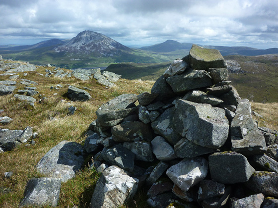
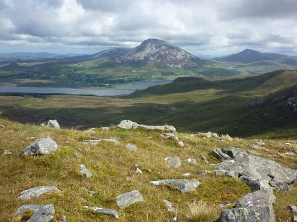
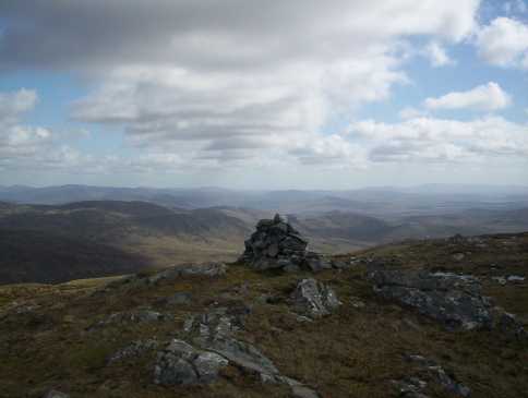
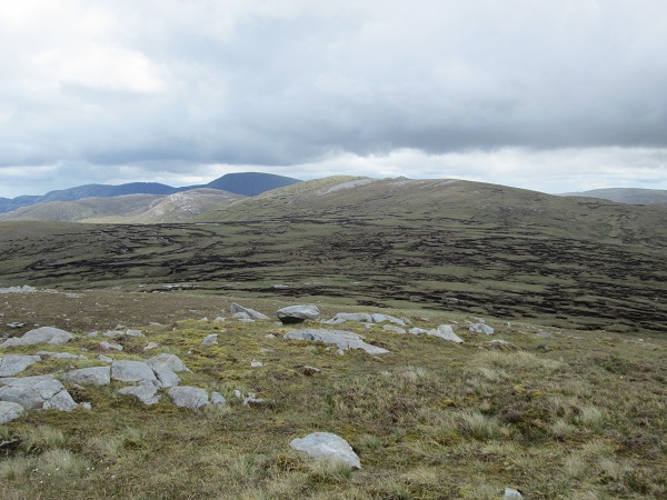
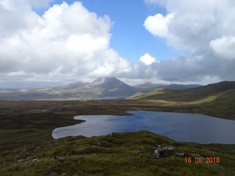
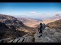
and tackled Grogan More first before making my way to Crocknafarragh. As seen on picture, and as described by Harry and eflanaga, the col between the two summits is covered with peat hags. Therefore I decided to head towards Grogan Beg (flat summit left on the picture, 424m point on OSI map), which was a good idea as it enabled me to enjoy firm ground and great views over Errigal and its neighbours between two peat hag sections. After crossing the last peat hags, a regular ascent starts, getting easier as the ground becomes firmer. From Grogan More through Grogan Beg, it is a 45-50 min walk to the 503m point (small rocky mound right of the summit on picture). Add a few more minutes to reach the top at 517m. Fantastic views all around, to Grogan More, the ocean and Tievealehid to the north, Errigal and Dooish to the north-east, and the Slieve Snaght range (see picture) to the south-east (could not see much to the west and south because of the cloudy weather). Prominent as it is, Crocknafarragh happens to be a good landmark to identify the surrounding summits. From the top it is a short, highly recommended stroll to Crocknafarragh SE Top (12-15 min) and Crockglass (add another 15 min). Finally made my way to Addernymore and back to the car via the road south of Lough Keel.

I would not necessarily recommend climbing Addernymore -unless you are a hill-bagger !- but going back along the ridge west of Crocknafarragh through 409m point. Or maybe continuing on the ridge north of Crockglass and down to Dunlewy Lough (if two cars available)... or maybe even starting a four-summit trip from there ?

Definitely an enjoyable walk, with no other difficulty than the distance and... the peat hags ! Rewarding views all along and all around and a great sensation of isolation, as I did not meet anybody until I was back on the road ! Linkback: mountainviews.ie/summit/418/comment/15026/
Read Less
Read More

            MountainViews.ie picture about Crocknafarragh (<em>Cnoc na bhFaircheach</em>)
Picture: View to NE of Crcknafarragh
The High Route around Glentornan Lough
by jsramsey1491 18 Aug 2018
Last Thursday (16/08/2018) a few friends and I decided to do a recce of a walk around Glentornan Lough. We started close to the Gaelic pitch on the southwestern shore of Lough Nacung Upper, passed by Grogan Beg on our right and continued on to the summit of Crocknafarragh and continued on circling Glentrnan Lough keeping to the high ground to Crockglass and eventually down the western side of a stream in full spate to the south eastern end of Lough Nacung Upper and along the road/track to the Gaelic pitch. The weather was mixed, a couple of showers , a fair wind and a lot of sunshine. The views were magnificent and the cloudscapes fantastic. The first mile or so at the start and the descent at the end, another mile or so, were very challenging but the remaining five miles were great. In my opinion the views on this walk are among the very best that Donegal has to offer.

Stewart Ramsey Linkback: mountainviews.ie/summit/418/comment/20025/
Read Less
Read More
EDIT Point of Interest
text
Videos


Recent Contributions
x
Conditions and Info
Use of MountainViews is governed by conditions and a privacy policy.
Read general information about the site.
Opinions in material here are not necessarily endorsed by MountainViews.
Hillwalking is a risk sport. Information in comments, walks, shared GPS tracks or about starting places may not be accurate for example as regards safety or access permission. You are responsible for your safety and your permission to walk.
See the credits and list definitions.

OSi logo
OSNI/LPS logo
Open Street Map
(Various variations used.)
British summit data courtesy:
Database of British & Irish Hills