Cookies.
This website uses cookies, which are small text files that the website puts on your device to facilitate operation. Cookies help us provide a better service to you. They are used to track general user traffic information and to help the website function properly.
Features
Nearby features appear when you click the map.
Declutter tracks on map.
Place Search
Video
X
Pub: by
Derryveagh Mountains Area , Cen: Glenveagh Upper Subarea
Feature count in area: 38, all in Donegal, OSI/LPS Maps: 1, 11, 2, 6
Highest Place: Errigal 751m

Starting Places (29) in area Derryveagh Mountains:
Aleahan Lough, Altderry Bridge, An Chúirt Hotel, Astelleen Burn Waterfall, Derryreel Lough, Dunlewy Lough E, Dunlewy Lough Viewing Point, Errigal Hostel, Errigal Parking, Glenveagh Bridge, Glenveagh National Park SW, Glenveigh Castle, Keel Lough N, Losset North, Lough Acrobane Farmhouse, Lough Ascardan, Lough Barra Slipway CP, Lough Barra W, Meenagoppoge Burn Bridge, Mín Uí Bhaoil, Muckish Gap Shrine, Muckish North Access Road, Nabrackbaddy Lough, Procklis Lough, River Barra Bridge NE, River Barra Bridge SW, Sand Lough NE, Sruhancrolee Bridge, Stranamarragh Bridge

Summits & other features in area Derryveagh Mountains:
Cen: Dooish: Dooish 651.5m, Dooish SW Top 528m, Dooish SE Top 553.9m, Saggartnadooish 506.4m, Saggartnadooish East Top 478.9m
Cen: Errigal: Errigal 751m, Mackoght 555m
Cen: Glenveagh Upper: Crockfadda 485m, Crockfadda East Top 454m, Crockballaghgeeha 480m, Crockmulroney 430m, Staghall Mountain 486m, Croaghnasaggart 480m, Maumlack 480m
Cen: Lough Keel (Meencorwick): Crockglass 489m, Addernymore 416m, Grogan More 457m, Crocknafarragh 517m, Crocknafarragh SE Top 470m
Cen: Slieve Snaght: Crockfadda 529m, Crockfadda NE Top 502m, Crocknasharragh 495m, Drumnalifferny Far NE Top 535m, Bingorms 578m, Drumnalifferny Mountain 596m, Drumnalifferny Mountain NE Top 585m, Slieve Snaght 678m
N: Aghla: Aghla Beg 563.9m, Aghla Beg South Top 602.3m, Aghla More 581.2m, Ardloughnabrackbaddy 472.5m, Crocknalaragagh 470.6m
N: Muckish: Muckish 667.1m, Croaghaderry 222m, Crockawama 238m, Derryreel 232m
S: Doochary: Croaghleconnell 266m
S: Dungloe: Crovehy 315m

Note: this list of places may include island features such as summits, but not islands as such.
Rating graphic.
Crockfadda East Top, 454m Hill An Cnoc Fada (mullach thoir) A name in Irish,
Place Rating ..
For origin of name, see An Cnoc Fada / Crockfadda., Donegal County in Ulster province, in no lists, An Cnoc Fada (mullach thoir) is the 719th highest place in Ireland.
Grid Reference B95538 16406, OS 1:50k mapsheet 1
Place visited by: 61 members, recently by: maitiuocoimin, Krzysztof_K, Ulsterpooka, dino, Grumbler, AlanReid, trostanite, eamonoc, f.sokol, Lauranna, markmjcampion, thrifleganger, Q35on, abcd, briankelly
I visited this place: NO (You need to be a logged-in member for this.)
Longitude: -8.070501, Latitude: 54.995101, Easting: 195538, Northing: 416406, Prominence: 29m,  Isolation: 0.6km
ITM: 595488 916391
Bedrock type: Coarse biotite granite & granodiorite, (Main Donegal Granite)

  Short or GPS IDs, 6 char: CrckEs, 10 char: CrckfdEstT

Linkback: https://mountainviews.ie/summit/605/
Gallery for Crockfadda East Top (An Cnoc Fada (mullach thoir)) and surrounds
No summary yet for this place .
Member Comments for Crockfadda East Top (An Cnoc Fada (mullach thoir))
Comment create / edit display placeholder

            MountainViews.ie picture about Crockfadda East Top (<em>An Cnoc Fada (mullach thoir)</em>)
Picture: https://www.youtube.com/watch?v=v254OGsah6w
A Gerry McVeigh Film
by CaptainVertigo 12 Apr 2015
Walking in Donegal - Poisoned Glen & Slieve Snaght

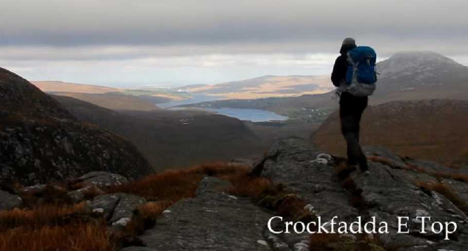
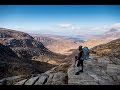
This is another top rank piece of work by one of our most experienced film makers. Gerry sets off for the Poisoned Glen at dusk before camping overnight . The opening shots set the scene in the fabulous Derryveaghs. In the morning we see Gerry progressing towards Crockfadda East Top. He highlights the deer fence. I think it's good to have close ups of the kind of everyday stuff we encounter on the hills. Bits of gritty realism simply bring the awesome scenery shots into better focus. Moments later we see the deer moving about. I can only guess at the work involved in all of this. Getting good shots takes concentration, time and patience.
In the background, really relaxing and rather apt music by Ben Rector:
There are way too many love songs
And I think they've got it all wrong
Cause life is not the mountain tops
It's the walking in between
And I like you walking next to me
On to Crockfadda, and then great views of the Poisoned Glen. The rich browns and light stone greys typical of the area are much in evidence on the way to Lough Atirrve, Lough Maumbeg, Lough Maam, and on to lough Slievesnaght. Although the day becomes increasingly overcast by the time Gerry reaches Slieve Snaght, this doesn't detract from the "feel" of the work. The colours, apart from the sky, remain vivid. Distinctive Errigal appears often in the background as a point of reference. The sense of a great wilderness is fully conveyed. Tell your friends!

https://www.youtube.com/watch?v=v254OGsah6w Linkback: mountainviews.ie/summit/605/comment/17924/
Read Less
Read More
EDIT Point of Interest
text
Videos


Recent Contributions
x
Conditions and Info
Use of MountainViews is governed by conditions and a privacy policy.
Read general information about the site.
Opinions in material here are not necessarily endorsed by MountainViews.
Hillwalking is a risk sport. Information in comments, walks, shared GPS tracks or about starting places may not be accurate for example as regards safety or access permission. You are responsible for your safety and your permission to walk.
See the credits and list definitions.

OSi logo
OSNI/LPS logo
Open Street Map
(Various variations used.)
British summit data courtesy:
Database of British & Irish Hills