This website uses cookies, which are small text files that the website puts on your device to facilitate operation. Cookies help us provide a better service to you. They are used to track general user traffic information and to help the website function properly.
Derryveagh MountainsArea, Cen: Lough Keel (Meencorwick)
Subarea
Feature count in area: 38, all in Donegal,
OSI/LPS Maps: 1, 11, 2, 6
Highest Place: Errigal 751m
Starting Places (29) in area Derryveagh Mountains: Aleahan Lough, Altderry Bridge, An Chúirt Hotel, Astelleen Burn Waterfall, Derryreel Lough, Dunlewy Lough E, Dunlewy Lough Viewing Point, Errigal Hostel, Errigal Parking, Glenveagh Bridge, Glenveagh National Park SW, Glenveigh Castle, Keel Lough N, Losset North, Lough Acrobane Farmhouse, Lough Ascardan, Lough Barra Slipway CP, Lough Barra W, Meenagoppoge Burn Bridge, Mín Uí Bhaoil, Muckish Gap Shrine, Muckish North Access Road, Nabrackbaddy Lough, Procklis Lough, River Barra Bridge NE, River Barra Bridge SW, Sand Lough NE, Sruhancrolee Bridge, Stranamarragh Bridge
Summits & other features in area Derryveagh Mountains: Cen: Dooish: Dooish 651.5m, Dooish SW Top 528m, Dooish SE Top 553.9m, Saggartnadooish 506.4m, Saggartnadooish East Top 478.9m Cen: Errigal: Errigal 751m, Mackoght 555m Cen: Glenveagh Upper: Crockfadda 485m, Crockfadda East Top 454m, Crockballaghgeeha 480m, Crockmulroney 430m, Staghall Mountain 486m, Croaghnasaggart 480m, Maumlack 480m Cen: Lough Keel (Meencorwick): Crockglass 489m, Addernymore 416m, Grogan More 457m, Crocknafarragh 517m, Crocknafarragh SE Top 470m Cen: Slieve Snaght: Crockfadda 529m, Crockfadda NE Top 502m, Crocknasharragh 495m, Drumnalifferny Far NE Top 535m, Bingorms 578m, Drumnalifferny Mountain 596m, Drumnalifferny Mountain NE Top 585m, Slieve Snaght 678m N: Aghla: Aghla Beg 563.9m, Aghla Beg South Top 602.3m, Aghla More 581.2m, Ardloughnabrackbaddy 472.5m, Crocknalaragagh 470.6m N: Muckish: Muckish 667.1m, Croaghaderry 222m, Crockawama 238m, Derryreel 232m S: Doochary: Croaghleconnell 266m S: Dungloe: Crovehy 315m
Note: this list of places may include island features such as summits, but not
islands as such.
Crocknafarragh SE Top, 470mHill Cnoc na bhFaircheach (mullach thoir theas) A name in Irish,
Place Rating ..
For origin of name, see Cnoc na bhFaircheach / Crocknafarragh., Donegal County in Ulster province, in no lists, Cnoc na bhFaircheach (mullach thoir theas) is the 666th highest place in Ireland.
Grid Reference B88423 16457,
OS 1:50k mapsheet 1 Place visited by: 32members, recently by: kernowclimber, mcrtchly, madfrankie, Colin Murphy, srr45, Lucky1, eamonoc, Ulsterpooka, ilenia, paulbrown, Lauranna, Fergalh, finkey86, shaunkelly, Cobhclimber
I visited this place: NO (You need to be a logged-in member for this.)
Short or GPS IDs, 6 char: CrckSE, 10 char: CrcknfSETp Linkback: https://mountainviews.ie/summit/549/
Gallery for Crocknafarragh SE Top (Cnoc na bhFaircheach (mullach thoir theas)) and surrounds
Summary
for Crocknafarragh SE Top (Cnoc na bhFaircheach (mullach thoir theas)):
Climb it, but include one or more "cousins"
Summary created by simon3, Harry Goodman
2018-06-20 21:21:47
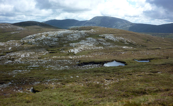
Picture: Crocknafarragh SE Top (middle foreground) from Crocknafarragh, Slieve Snaght (background)
The way to Crocknafarragh SE Top can follow the full route up to Crocknafarragh with an additional 700m walk out to the lesser top or, part of the way up, by contouring up and around the S flanks of Crocknafarragh and then making directly for the SE Top. Both options are given in the following route descriptions . Park off road at Keel L (B846 167) and walk SE on a track, around the N side of Lough Caol, to its end A (B850 163). Go NE (left) up hill along the line of a stream for about 200m and then up the open hillside to B (B861 166) .
Route 1: Continue up ENE to Pt. 503 C (B874 168). It is then a short drop down SE past tiny Mullincrick Lough (on right) and an equally short walk up to Crocknafarragh summit cairn at D (B878 168). Continue down SE to a col and then up over Pt 463 E (B883 165) to a small ring contour (470m) where a small cairn marks the high point of Crocknafarragh SE Top.
Route 2: From Pt 409 B (B861 166) contour E up and around the flanks of Crocknafarragh past the S tip of Mullincrick Lough F (B876 166). From here continue on to Crocknafarragh SE Top. This more direct approach has the disadvantage that it excludes the fine views to be seen from Crocknafarragh and saves little in terms of effort. This is a hill that will rarely,if ever, be visited in it's own right and suffers somewhat by being overshadowed by it's higher "cousins". Any views that it enjoys are even better and more expansive from either Crocknafarragh or Crockglass to the east and west respectively.
Worth seeing but not worth going to see (in its own right)
by Harry Goodman
7 Nov 2011
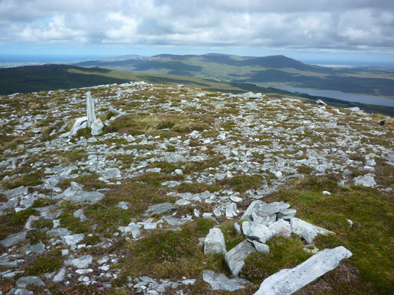
I crossed Crocknafarragh SE Top on 10 Aug 2010 as part of a round of five hills not previously visited . ( See my comments on Crocknafarragh for earlier part of route.) The approach from Crocknafarragh G (B87811 16752) was an easy short walk down to the coll and then up over Pt 463 to a small ring contour (470m) about 200 metres further E across the flatish top. A small cairn marks the high point H (B88423 16445) and just a few metres away is an even smaller cairn that could also lay claim to this distinction. I leave it to those with high quality technology to decide on a precise location on some future visit! Both cairns are shown in the photo. This is a rather remote top and is not one that will be singled out for climbing in its own right. Rather I feel it will only be visited, as in my case, when climbing others in the area. It suffers somewhat by being overshadowed by its higher "cousins" and any panorama that it enjoys is even better and more widespread from either Crocknafarragh or Crockglass to its west and east respectively. From here my next objective was Crockglass some 800 metres to the NE. Linkback: mountainviews.ie/summit/549/comment/6005/
Use of MountainViews is governed by conditions and a privacy policy.
Read general information about the site. Opinions in material here are not necessarily endorsed by MountainViews.
Hillwalking is a risk sport. Information in comments, walks, shared GPS tracks or about starting places may
not be accurate for example as regards safety or access permission. You are responsible for your safety and your permission to walk.
See the credits and list definitions.


 Our Facebook page.