Members and Supporters, the MountainViews Committee requests your help to meet the costs of the website and of other activities such as insured events or publications.
Feature count in area: 38, all in Donegal,
OSI/LPS Maps: 1, 11, 2, 6
Highest Place: Errigal 751m
Starting Places (29) in area Derryveagh Mountains: Aleahan Lough, Altderry Bridge, An Chúirt Hotel, Astelleen Burn Waterfall, Derryreel Lough, Dunlewy Lough E, Dunlewy Lough Viewing Point, Errigal Hostel, Errigal Parking, Glenveagh Bridge, Glenveagh National Park SW, Glenveigh Castle, Keel Lough N, Losset North, Lough Acrobane Farmhouse, Lough Ascardan, Lough Barra Slipway CP, Lough Barra W, Meenagoppoge Burn Bridge, Mín Uí Bhaoil, Muckish Gap Shrine, Muckish North Access Road, Nabrackbaddy Lough, Procklis Lough, River Barra Bridge NE, River Barra Bridge SW, Sand Lough NE, Sruhancrolee Bridge, Stranamarragh Bridge
Summits & other features in area Derryveagh Mountains: Cen: Dooish: Dooish 651.5m, Dooish SW Top 528m, Dooish SE Top 553.9m, Saggartnadooish 506.4m, Saggartnadooish East Top 478.9m Cen: Errigal: Errigal 751m, Mackoght 555m Cen: Glenveagh Upper: Crockfadda 485m, Crockfadda East Top 454m, Crockballaghgeeha 480m, Crockmulroney 430m, Staghall Mountain 486m, Croaghnasaggart 480m, Maumlack 480m Cen: Lough Keel (Meencorwick): Crockglass 489m, Addernymore 416m, Grogan More 457m, Crocknafarragh 517m, Crocknafarragh SE Top 470m Cen: Slieve Snaght: Crockfadda 529m, Crockfadda NE Top 502m, Crocknasharragh 495m, Drumnalifferny Far NE Top 535m, Bingorms 578m, Drumnalifferny Mountain 596m, Drumnalifferny Mountain NE Top 585m, Slieve Snaght 678m N: Aghla: Aghla Beg 563.9m, Aghla Beg South Top 602.3m, Aghla More 581.2m, Ardloughnabrackbaddy 472.5m, Crocknalaragagh 470.6m N: Muckish: Muckish 667.1m, Croaghaderry 222m, Crockawama 238m, Derryreel 232m S: Doochary: Croaghleconnell 266m S: Dungloe: Crovehy 315m
Note: this list of places may include island features such as summits, but not
islands as such.
Crockfadda, 529mMountain An Cnoc Fada A name in Irish,
Place Rating ..
(Ir. An Cnoc Fada [OSI], 'the long hill'), Donegal County in Ulster province, in Arderin Lists, An Cnoc Fada is the 478th highest place in Ireland.
Grid Reference B90990 13637,
OS 1:50k mapsheet 1 Place visited by: 84members, recently by: Carolineswalsh, NualaB, nupat, Seamy13, TessDws, Cecil1976, annem, srr45, pcoleman, DNicholson, AlanReid, pmeldrum, No1Grumbler, eamonoc, Lucky1
I visited this place: NO (You need to be a logged-in member for this.)
Longitude: -8.141517, Latitude: 54.970077, Easting: 190990, Northing: 413637,
Prominence: 80m, Isolation: 1km ITM: 590938 913613 Bedrock type: Coarse biotite granite & granodiorite, (Main Donegal Granite) Notes on name: Note that there is another hill of this name between Slieve Snaght and Dooish.
Short or GPS IDs, 6 char: Crckfd, 10 char: Crockfadda Linkback: https://mountainviews.ie/summit/396/
Gallery for Crockfadda (An Cnoc Fada) and surrounds
Summary
for Crockfadda (An Cnoc Fada):
Ever met a million rural midges?
Summary created by Harry Goodman, simon3, jackill
2012-08-17 11:42:37
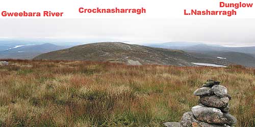
Picture: Looking back to Crockfadda (centre) from Crocknasharragh, with Slieve Snaght (back right)
Approach from Glenveagh along the R254. Park in the small slipway carpark at Barra Slip (B92918 12363), room for 5-6 cars. Walk northeast along the road for 1km, to a bridge. Go left and follow the Sruhancrolee stream northwest over marshy ground before ascending steeply next to a small waterfall. As the ground becomes less steep, around A (B920 137), leave the stream and go W across a boggy kilometre to the small summit cairn on an otherwise featureless grass covered plateau. Return by way of ascent. If you climb here in summer months bring midge repellant.
Picture: Lough Agannive with Lough Atirrive partly visible above & Crockglass rising behind from northern slo
eflanaga on Crockfadda
by eflanaga
20 Apr 2006
(Climbed April 17th – see Crockfadda North-East Top for previous stage in walk). Leaving Crockfadda North-East Top I started to make my weary way south-west towards my final target. While this straight as the crow flies route was not particularly steep, my knee was beginning to act up again making the 60m descent to a narrow col followed by an 87m climb to Crockfadda’s summit a little more difficult than it should have been. Nevertheless, I reached the top in reasonable time. After taking a few photographs of Crocknafarragh, Crockglass and Lough Atirrive to the north-west, Errigal to the north and Slieve Snaght to the north-east I was ready to make for home. I had only walked about 200m when I was greeted by the start of the heaviest drizzle of the day. This was to make the last leg of the walk somewhat miserable. I decided to follow a route along the course of the Devlin River back to Dunlewey. About ten minutes after leaving Crockfadda’s summit Lough Agannive came into view down below me. I had initially taken a bearing, which would bring me east of Agannive, crossing the stream that feeds the Devlin River from the lough. However, I took a little detour to explore one of the small sandy beaches at the lough’s edge. After crossing the stream I decided to keep to the higher ground west of the river as the going along the riverbank was extremely difficult. I maintained a height of about 300 metres for 1K dropping gradually to a height of approximately 220m before reaching the final descent back down to Dunlewey Old Church. The terrain all along this route is rough and uneven bog. The heavy drizzle and recent heavy rainfall had left the ground extremely wet. This final leg of the walk - from Crockfadda to the Old Church ruins seeming twice as long as the 5.7K it actually was. Cold and tired I reached the height overlooking the church and dropped of the final slope crossing the Devlin River and a small stream by way of stepping stones to rejoin the track and little bridge I had crossed earlier in the day. A short walk brought me back to the car where a litre of water and 500mls of energy drinks was greedily consumed. After all that a two and a half hour drive home left me exhausted but delighted about what had proved to be a fairly challenging but largely enjoyable 14K horseshoe walk in my favourite part of the country. I would thoroughly recommend it – but if possible pick a drier and sunnier day if you can! Linkback: mountainviews.ie/summit/396/comment/2288/
Read Less
Read More
zeaphod on Crockfadda
by zeaphod
29 Feb 2004
Fairly easy walk up from the Owencarrow valley road, although the long grass (chest height in places when I last walked here) and uneven ground make it seem much harder. Once onto the tops, the going is much easier, with large slabs of rock, interspersed with bog/water. You have a good chance of spotting herds of deer up here. Linkback: mountainviews.ie/summit/396/comment/865/
Read Less
Read More
Picture: West Donegal revealed.
simon3 on Crockfadda
by simon3
17 Sep 2005
Crockfadda will reward you with a great view of the West Donegal coast on a good day. The picture is a SW view, though further north you should be able to see Aran Island. Linkback: mountainviews.ie/summit/396/comment/1946/
Read Less
Read More
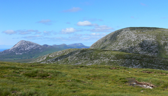
Picture: View NE from Crockfadda to Crockfadda NE Top (middle foreground) and Slieve Snaght (right)
Just another top.
by Harry Goodman
11 Aug 2012
I came to Crockfadda on 26 July 2012 as the fifth in a round of six tops in the Derryveagh Mts. (For previous part of the route see my comments on Crockfadda NE Top.) From the saddle below Crockfadda NE Top B (B913 140) I continued up and along SW for some 500m to the top, marked by a small pile of stones, on yet another flat topped featureless grass covered plateau not uncommon in these hills. The views were similar to those I had seen from Crockfadda NE Top except that Crocknasharragh the final hill in my round was now in view some 1.6k further SW. I therefore pressed on by continuing down to the saddle with Crocknasharragh C (B906 133). Linkback: mountainviews.ie/summit/396/comment/14746/
Read Less
Read More
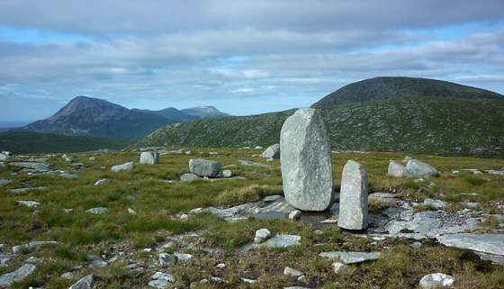
Picture: The boulder strewn summit area.
Boggy Top
by Aidy
10 Apr 2016
Reached from Crockfadda NE Top, which was a short walk, but over difficult ground in places. Very boggy with a lot of tussocky grass. To get back down to the R254 I headed east to near point B from previous comments, made the steep descent beside the waterfall, and had an easy walk from there to the road. Linkback: mountainviews.ie/summit/396/comment/18489/
Use of MountainViews is governed by conditions and a privacy policy.
Read general information about the site. Opinions in material here are not necessarily endorsed by MountainViews.
Hillwalking is a risk sport. Information in comments, walks, shared GPS tracks or about starting places may
not be accurate for example as regards safety or access permission. You are responsible for your safety and your permission to walk.
See the credits and list definitions.


 Our Facebook page.