Welcome to MountainViews
If you want to use the website often please enrol (quick and free) at top right.
If you want to use the website often please enrol (quick and free) at top right.
Overview

For more map options click on any overview map area or any detail map feature.
Detail Map Features
Showing 8 items:
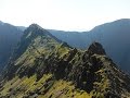
Beann Bhán 459.5m, Beann Dubh 450.5m, Beendarrig 449.7m,
3482, 10km
4755, 9km
1265, 8km
2992, 7km
1503, 4km
Beann Bhán 459.5m, Beann Dubh 450.5m, Beendarrig 449.7m,
Tracks:
Find Suggested Walks
Find hill, mountain, island, coastal feature.
Videos


Recent Contributions
 Get Notifications
Get Notifications
Carricktriss Gorse: Safe access to this hill no longer seems possible
 TommyMc
Binnion: Tullagh Bay and Rockstown Harbour
 Jim_Brady
Donations Drive, now finished.
Good, relatively easy double bag
 Colin Murphy
Crocknapeast: Long walk up windfarm roads.
 Collaborative entry
Mulnanaff: Longish walk up windfarm road.
 Collaborative entry
Lake District: Dale Head Horseshoe
Double bag mostly on windfarm tracks.
 Colin Murphy
Binbane NE Top: Simple bag from its neighbouring top.
 Collaborative entry
Lake District: Coledale Horseshoe
Binbane: Steepish approach to relatively easy Carn.
 Collaborative entry
Crucknaree: Magnificent views!
 paddyhillsbagger
Conditions and Info
Use of MountainViews is governed by conditions and a privacy policy.
Read general information about the site.
Opinions in material here are not necessarily endorsed by MountainViews.
Hillwalking is a risk sport. Information in comments, walks, shared GPS tracks or about starting places may not be accurate for example as regards safety or access permission. You are responsible for your safety and your permission to walk.
See the credits and list definitions.
 Visit our Facebook page.
Video display
MacGillycuddy's Reeks
Area SW: Bridia Subarea
Place count in area: 29,
OSI/LPS Maps: 78, EW-KNP, EW-R
Highest place: Carrauntoohil, 1038.6m
Maximum height for area: 1038.6 metres,
Maximum prominence for area: 1038.6 metres,
Places in area MacGillycuddy's Reeks:
Cen: Reeks West:Beenkeragh 1008.2mCaher 1000mCaher West Top 973.4mCarrauntoohil 1038.6mCnoc Íochtair 746.3mHag's Tooth 662mKnockbrinnea East Top 845.4mKnockbrinnea West Top 852.2mThe Bones Peak 956.5mSkregmore 847.7mStumpa Bharr na hAbhann 852.1m
E: Cnoc an Bhráca:Cnoc an Bhráca 728mCnoc na dTarbh 655mStrickeen 440m
N: Reeks North:Knockbrack 425mKnocknabrone Hill 353mSkregbeg 573m
NW: Gortnagan:Gortnagan Beg 298m
SE: Reeks East:Brassel Mountain 575mCnoc an Chuillinn 954.6mCnoc an Chuillinn East Top 922.9mKnocknapeasta 985.1mCnoc na Toinne 844.1mCruach Mhór 930.8mMaolán Buí 968.9mThe Big Gun 939.9m
SW: Bridia:Beann Bhán 459.5mBeendarrig 449.7mBeann Dubh 450.5m
Note: this list of places includes island features such as summits, but not islands as such.
Highest place:
Carrauntoohil, 1038.6mPlaces in area MacGillycuddy's Reeks:
Cen: Reeks West:
Beenkeragh 1008.2mCaher 1000mCaher West Top 973.4mCarrauntoohil 1038.6mCnoc Íochtair 746.3mHag's Tooth 662mKnockbrinnea East Top 845.4mKnockbrinnea West Top 852.2mThe Bones Peak 956.5mSkregmore 847.7mStumpa Bharr na hAbhann 852.1mE: Cnoc an Bhráca:
Cnoc an Bhráca 728mCnoc na dTarbh 655mStrickeen 440mN: Reeks North:
Knockbrack 425mKnocknabrone Hill 353mSkregbeg 573mNW: Gortnagan:
Gortnagan Beg 298mSE: Reeks East:
Brassel Mountain 575mCnoc an Chuillinn 954.6mCnoc an Chuillinn East Top 922.9mKnocknapeasta 985.1mCnoc na Toinne 844.1mCruach Mhór 930.8mMaolán Buí 968.9mThe Big Gun 939.9mSW: Bridia:
Beann Bhán 459.5mBeendarrig 449.7mBeann Dubh 450.5mNote: this list of places includes island features such as summits, but not islands as such.

Bedrock type: Purple sandstone & siltstone, (Ballinskelligs Sandstone Formation)
Beann Dubh is the 734th highest place in Ireland. Beann Dubh is the second most westerly summit in the MacGillycuddy's Reeks area.
Linkback: https://mountainviews.ie/summit/613/
COMMENTS for Beann Dubh 1 of 1  Follow this place's comments

|
|
|
|
||
| MountainViews.ie, a Hill-walking Website for the island of Ireland. 2400 Summiteers, 1480 Contributors, maintainer of lists: Arderins, Vandeleur-Lynams, Highest Hundred, County Highpoints etc | |||