This website uses cookies, which are small text files that the website puts on your device to facilitate operation. Cookies help us provide a better service to you. They are used to track general user traffic information and to help the website function properly.
Feature count in area: 29, all in Kerry,
OSI/LPS Maps: 78, EW-KNP, EW-R
Highest Place: Carrauntoohil 1038.6m
Starting Places (19) in area MacGillycuddy's Reeks: Ballaghbeama Gap, Bridia Valley End, Cronins Yard, Gap of Dunloe Head of, Gap of Dunloe Kate K, Glashaknockbrassel Stream, Glasheenoultagh Stream, Hydro Road CP, Knocknsallagh Bridge, Lisleibane Trail Head, Lough Acoose North, Lough Acoose West, Lough Cappanlea OEC, Lough Caragh SW, Lough Fada N, Lough Reagh N, Maghanlawaun Bridia Valley, Shamrock Farmhouse B&B, Tomies Lough Leane NW
Summits & other features in area MacGillycuddy's Reeks: Cen: Reeks West: Beenkeragh 1008.2m, Caher 1000m, Caher West Top 973.4m, Carrauntoohil 1038.6m, Cnoc Íochtair 746.3m, Hag's Tooth 662m, Knockbrinnea East Top 845.4m, Knockbrinnea West Top 852.2m, The Bones Peak 956.5m, Skregmore 847.7m, Stumpa Bharr na hAbhann 852.1m E: Cnoc an Bhráca: Cnoc an Bhráca 728m, Cnoc na dTarbh 655m, Strickeen 440m N: Reeks North: Knockbrack 425m, Knocknabrone Hill 353m, Skregbeg 573m NW: Gortnagan: Gortnagan Beg 298m SE: Reeks East: Brassel Mountain 575m, Cnoc an Chuillinn 954.6m, Cnoc an Chuillinn East Top 922.9m, Knocknapeasta 985.1m, Cnoc na Toinne 844.1m, Cruach Mhór 930.8m, Maolán Buí 968.9m, The Big Gun 939.9m SW: Bridia: Beann Bhán 459.5m, Beendarrig 449.7m, Beann Dubh 450.5m
Note: this list of places may include island features such as summits, but not
islands as such.
Gortnagan Beg, 298mHill
Place Rating ..
, Gortnagan More, Muireann Mhór, Kerry County in Munster province, in Binnion Lists, Gortnagan Beg is the 1165th highest place in Ireland. Gortnagan Beg is the most westerly summit and also the second most northerly in the MacGillycuddy's Reeks area.
Grid Reference V72100 88500,
OS 1:50k mapsheet 78 Place visited by: 14members, recently by: annem, eamonoc, chelman7, Taisce, Fergalh, omurchu, markmjcampion, ciarraioch, thomas_g, trekker, frankmc04, spoodle58, chalky, dbloke
I visited this place: NO (You need to be a logged-in member for this.)
Short or GPS IDs, 6 char: GrtnBg, 10 char: GrtngnBeg Linkback: https://mountainviews.ie/summit/1145/
Gallery for Gortnagan Beg and surrounds
Summary
for Gortnagan Beg :
Small hill with great views
Summary created by thomas_g
2017-05-29 09:32:36
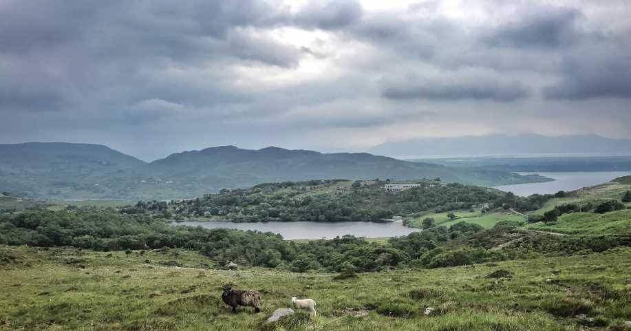
Gortnagan Beg might be diminutive in stature but has fine views and some steep ground.
The best approach is from the NE where there is a stile on the roadside. Parking is scarce so the best option is to park outside Cappanalea and walk up the road.
There are access issues with respect to the land around Loughancummeen, so while it's tempting to go west from Gortnagan Beg and circuit the lake, this should be avoided, a descent route that skirts the west side of Lough Cappananlea is best.
Gortnagan Beg turned out to be my 500th peak. The bog was dryish, the rain threatened but waited until I got back to the car and the midges had other targets; what more could you ask for.
The peak proper seems to be further E than indicated on the OSI map. Linkback: mountainviews.ie/summit/1145/comment/19530/
Use of MountainViews is governed by conditions and a privacy policy.
Read general information about the site. Opinions in material here are not necessarily endorsed by MountainViews.
Hillwalking is a risk sport. Information in comments, walks, shared GPS tracks or about starting places may
not be accurate for example as regards safety or access permission. You are responsible for your safety and your permission to walk.
See the credits and list definitions.


 Our Facebook page.