This website uses cookies, which are small text files that the website puts on your device to facilitate operation. Cookies help us provide a better service to you. They are used to track general user traffic information and to help the website function properly.
MacGillycuddy's ReeksArea, E: Cnoc an Bhráca
Subarea
Feature count in area: 29, all in Kerry,
OSI/LPS Maps: 78, EW-KNP, EW-R
Highest Place: Carrauntoohil 1038.6m
Starting Places (19) in area MacGillycuddy's Reeks: Ballaghbeama Gap, Bridia Valley End, Cronins Yard, Gap of Dunloe Head of, Gap of Dunloe Kate K, Glashaknockbrassel Stream, Glasheenoultagh Stream, Hydro Road CP, Knocknsallagh Bridge, Lisleibane Trail Head, Lough Acoose North, Lough Acoose West, Lough Cappanlea OEC, Lough Caragh SW, Lough Fada N, Lough Reagh N, Maghanlawaun Bridia Valley, Shamrock Farmhouse B&B, Tomies Lough Leane NW
Summits & other features in area MacGillycuddy's Reeks: Cen: Reeks West: Beenkeragh 1008.2m, Caher 1000m, Caher West Top 973.4m, Carrauntoohil 1038.6m, Cnoc Íochtair 746.3m, Hag's Tooth 662m, Knockbrinnea East Top 845.4m, Knockbrinnea West Top 852.2m, The Bones Peak 956.5m, Skregmore 847.7m, Stumpa Bharr na hAbhann 852.1m E: Cnoc an Bhráca: Cnoc an Bhráca 728m, Cnoc na dTarbh 655m, Strickeen 440m N: Reeks North: Knockbrack 425m, Knocknabrone Hill 353m, Skregbeg 573m NW: Gortnagan: Gortnagan Beg 298m SE: Reeks East: Brassel Mountain 575m, Cnoc an Chuillinn 954.6m, Cnoc an Chuillinn East Top 922.9m, Knocknapeasta 985.1m, Cnoc na Toinne 844.1m, Cruach Mhór 930.8m, Maolán Buí 968.9m, The Big Gun 939.9m SW: Bridia: Beann Bhán 459.5m, Beendarrig 449.7m, Beann Dubh 450.5m
Note: this list of places may include island features such as summits, but not
islands as such.
Strickeen, 440mHill Struicín A name in Irish,
Place Rating ..
, Kerry County in Munster province, in Carn Lists, Struicín is the 775th highest place in Ireland. Struicín is the most northerly summit and also the most easterly in the MacGillycuddy's Reeks area.
Grid Reference V86625 88222,
OS 1:50k mapsheet 78 Place visited by: 151members, recently by: maoris, Brianodonovankil, Caithniadh, niallellis, DeirdreM, farmerjoe, MichaelButler, abcd, Deise-Man, childminder05, nesa1206, Moses, SmirkyQuill, John.geary, Bissboy
I visited this place: NO (You need to be a logged-in member for this.)
Short or GPS IDs, 6 char: Strckn, 10 char: Strickeen Linkback: https://mountainviews.ie/summit/656/
Gallery for Strickeen (Struicín) and surrounds
Summary
for Strickeen (Struicín):
Viewing platform with track up.
Summary created by simon3
2013-10-24 09:08:00
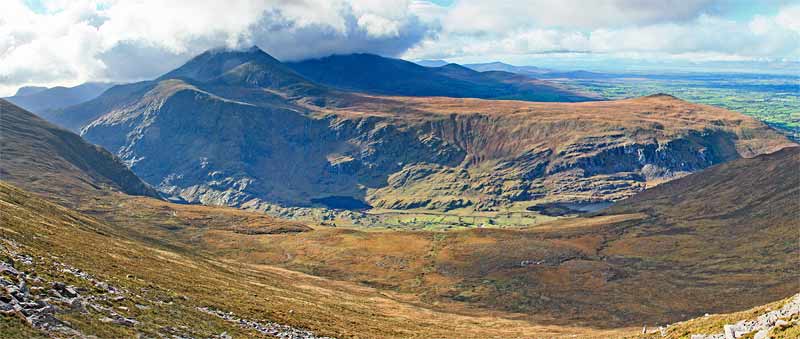
Picture: Strickeen to the right has views to the Reeks, left.
An obvious way to climb Strickeen is from Kate Kearney's Cottage where there is a big car park GapDun KK (V8808 8881). Walk south into the Gap of Dunloe and ascend on a rough track starting at A (V8B (V775 883)1). Follow the zig zag path until you start to descend at around 400m then head west for the top.
Srickeen at 440m is a great platform for viewing and photographing both the countryside but also the east end of the Reeks and the Purple Mountain group.
It also provides an initial point on a longer walk into the Reeks.
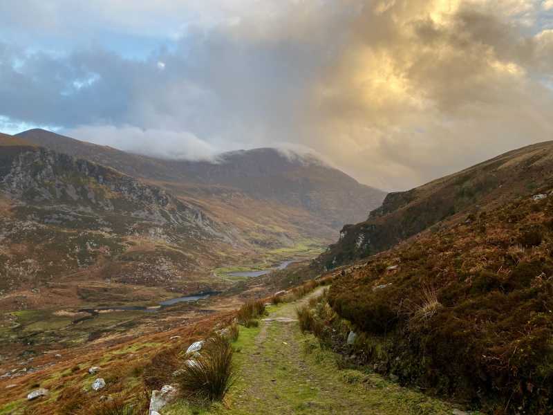
Picture: Looking SW across the Hag's Glen to Carrauntohill and Beenkeragh from Struicin Hill
Harry Goodman on Strickeen
by Harry Goodman
28 Sep 2009
I agree with dbloke that a climb up Struicin Hill from the Gap of Dunloe is well worthwhile. This would be particularly so for someone, short of time, but with a desire to get at least a flavour of Kerry's finest. The view down across the Hag's Glen to the two highest peaks in Ireland, Carrauntohill and Beenkeeragh, is very rewarding (see photo), as are the other views already mentioned in dblokes comment's. Clearly if time and energy allows the route up this hill opens up the way to the full Eastern Reeks Ridge. Linkback: mountainviews.ie/summit/656/comment/4154/
Read Less
Read More
Picture: The girls will never believe how big it was...
dbloke on Strickeen
by dbloke
22 Apr 2008
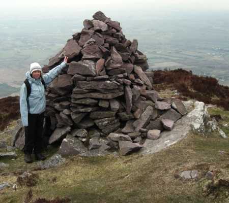
Poor Struicín (aka Strickeen: Either a "crested ridge" or "top of the bog" according to Seán Higgisson in his books A Walker's Guide to Killarney and Hillwalker's Guide to Carrauntoohil). Even the fine outstanding members of Mountain Views have yet to find it worthy of comment - probably due to the aforementioned bog - and likely pass it by on their charge up Cnoc an Bhráca and off across the ridges of the Reeks. However, on a calm, mild, mid April day (when unbelievably it has hardly rained for over a week) it's a great little hill. Starting from Kate Kearney's and following the road into the Gap of Dunloe you soon come to the start of the zig-zag track. The nice Kerry Mountain Rescue people have helpfully left a sign to point the way and ward off any foolhardy tourists thinking about trekking into the mountains. Most of them here don't seem to walk much further than this point or even get out of their cars. The path gently meanders upwards. Once reaching the plateau the track that leads to the summit is easily visible off to the right. In dry conditions the short steep climb to the top is the consistency of chocolate brownies. The largest cairn I've yet encountered can be found here, and for some reason somebody has decided that what this small little hill needs is three of them! Maybe it's a cry for attention... If you want to introduce somebody to hillwalking and happen to be in vicinity of Killarney, Torc mountain is a great starter - not requiring the purchase of any stout footwear or sensible clothing, so it would seem. A great place to take the kids. On a sunny weekend afternoon though every man and his dog is up there. Struicín in comparison was utterly deserted on both occassions I've climbed it. And it's shorter. The panoramic view from the top is incredible for such little effort, taking in Loch Leane, Tomies, Purple, the Gap, Cnoc an Bhraca and all the peaks surrounding the Hag's Glen. Total trip was only 2 hours, and we're slow. In bad weather or after a lot or recent rain ignore everything I just said... Linkback: mountainviews.ie/summit/656/comment/3059/
Read Less
Read More
Strickeen
by bjsmyth
9 Oct 2014
Used the Struicin track two weeks ago for first time in a couple of years. Surprised to find very substantial fence blocking route from end of track to top of Cnoc an Bhraca. Did not cross the fence as there id no stile but followed it due west for about 1 km where it turns due south and can be followed right to summit of Cnoc an Bhraca. I mention this as I encountered five walkers coming up Cnoc an Bhraca who had apparently climbed over the fence on leaving Struicin track only to have to climb over it again to gain the summit of Cnoc an Bhraca.
If you're into fences this one is magnificent! Very substantial, strong and beautifully erected.. It would be a shame if walkers were to damage it by climbing over when not necessary to gain Cnoc an Bhraca. On the way down I enquired from a local the origin of the fence and it was explained, somewhat vaguely, that the area had to be fenced off as commonage under EU regulations but having been erected it was now unclear if it had been required! Anyway walkers please don't damage it by climbing over! Linkback: mountainviews.ie/summit/656/comment/17716/
Read Less
Read More
Picture: Evening light bathing the Gap of Dunloe.
Convenient car parking
by Colin Murphy
28 Feb 2022
To save yourself the initial road walk from the car park at Kate Kearney's, I'm pleased to report that there is now room to park almost at the starting point of the track at V8B (V775 883). Had a very enjoyable climb up this mountain, with a good track almost the entire way, and was blessed to be granted a view of the Gap of Dunloe on our descent bathed in warm evening light, while silky cloud topped the nearby mountains. Linkback: mountainviews.ie/summit/656/comment/23424/
Use of MountainViews is governed by conditions and a privacy policy.
Read general information about the site. Opinions in material here are not necessarily endorsed by MountainViews.
Hillwalking is a risk sport. Information in comments, walks, shared GPS tracks or about starting places may
not be accurate for example as regards safety or access permission. You are responsible for your safety and your permission to walk.
See the credits and list definitions.


 Our Facebook page.