Members and Supporters, the MountainViews Committee requests your help to meet the costs of the website and of other activities such as insured events or publications.
MacGillycuddy's ReeksArea, Cen: Reeks West
Subarea
Feature count in area: 29, all in Kerry,
OSI/LPS Maps: 78, EW-KNP, EW-R
Highest Place: Carrauntoohil 1038.6m
Starting Places (19) in area MacGillycuddy's Reeks: Ballaghbeama Gap, Bridia Valley End, Cronins Yard, Gap of Dunloe Head of, Gap of Dunloe Kate K, Glashaknockbrassel Stream, Glasheenoultagh Stream, Hydro Road CP, Knocknsallagh Bridge, Lisleibane Trail Head, Lough Acoose North, Lough Acoose West, Lough Cappanlea OEC, Lough Caragh SW, Lough Fada N, Lough Reagh N, Maghanlawaun Bridia Valley, Shamrock Farmhouse B&B, Tomies Lough Leane NW
Summits & other features in area MacGillycuddy's Reeks: Cen: Reeks West: Beenkeragh 1008.2m, Caher 1000m, Caher West Top 973.4m, Carrauntoohil 1038.6m, Cnoc Íochtair 746.3m, Hag's Tooth 662m, Knockbrinnea East Top 845.4m, Knockbrinnea West Top 852.2m, The Bones Peak 956.5m, Skregmore 847.7m, Stumpa Bharr na hAbhann 852.1m E: Cnoc an Bhráca: Cnoc an Bhráca 728m, Cnoc na dTarbh 655m, Strickeen 440m N: Reeks North: Knockbrack 425m, Knocknabrone Hill 353m, Skregbeg 573m NW: Gortnagan: Gortnagan Beg 298m SE: Reeks East: Brassel Mountain 575m, Cnoc an Chuillinn 954.6m, Cnoc an Chuillinn East Top 922.9m, Knocknapeasta 985.1m, Cnoc na Toinne 844.1m, Cruach Mhór 930.8m, Maolán Buí 968.9m, The Big Gun 939.9m SW: Bridia: Beann Bhán 459.5m, Beendarrig 449.7m, Beann Dubh 450.5m
Note: this list of places may include island features such as summits, but not
islands as such.
Knockbrinnea West Top, 852.2mMountain Cnoc Broinne (mullach thiar) A name in Irish,
Place Rating ..
(Ir. Cnoc Broinne [TH], 'hill of the breast'), Stuaic a' Mhada Rua, Kerry County in Munster province, in Arderin Beg, Vandeleur-Lynam Lists, Knockbrinnea West Top is the 16th highest place in Ireland.
Grid Reference V80778 85816,
OS 1:50k mapsheet 78 Place visited by: 293members, recently by: kelleher, rhw, maoris, Carolineswalsh, knightsonhikes, ToughSoles, noelcurt, conorjob, abeach, Krzysztof_K, osullivanm, Gergrylls, therealcrow, overthehill67, jackos
I visited this place: NO (You need to be a logged-in member for this.)
Longitude: -9.737134, Latitude: 52.01207, Easting: 80779, Northing: 85816,
Prominence: 29.7m, Isolation: 0.3km ITM: 480755 585875 Bedrock type: Well-bedded grey sandstone, (Lough Acoose Sandstone Formation) Notes on name: Knockbrinnea is a shoulder of Beenkeragh overlooking the Hag's Glen.
Short or GPS IDs, 6 char: KnckWs, 10 char: KnckbrWstT Linkback: https://mountainviews.ie/summit/16/
Gallery for Knockbrinnea West Top (Cnoc Broinne (mullach thiar)) and surrounds
Summary
for Knockbrinnea West Top (Cnoc Broinne (mullach thiar)):
Larger Twin
Summary created by simon3, Colin Murphy, march-fixer
2024-04-19 09:29:07
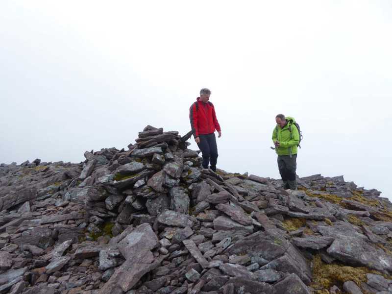
Picture: Summit cairn is surrounded by rock fragments.
This top is the larger of the two Knockbrinnea peaks. There are excellent views N to Castlemaine, NE to Killarney and SE into the Hag's Glen. It is best approached from the car-park at Lisleibane Lilybane (V82714 87304) via Knockbrinnea (E).
An alternative starting point is Cronin's Carpark at Cronins (V83600 87300) B. Proceed along the track into the Hag's Glen until the bridge crosses the river at A (V826 864) C. From here proceed directly up the slope to the west. Terrain is mostly grass at first and firm underfoot and initially slope is reasonably gentle, but becomes very steep after about 400M altitude and remains so pretty much to the summit, which is a large rocky area topped by a cairn. 2 hours from car to summit
The two tops are about 400m apart with a height difference of only 7m, with Knockbrinnea (W) being the higher.
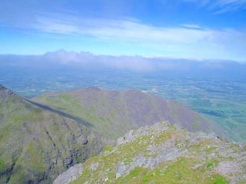
Picture: Knockbrinnea West Top from Knockbrinnea East Top
Updated Eflanagan on the Knockbrinneas
by eflanaga
19 Apr 2024
From summit of its sister peak to the East there is a short walk over rocky ground passing the side of a small spot height (unless you can be bothered going over its top) to the West Top summit. Here again there are wonderful views north across the plains, ENE towards Lough Leane, Purple Mountain, Tomies Mountain and the Reeks Ridge as it wends its way around towards Carrauntoohill. The Northern aspect of Carrauntoohill is clearly seen from this point showing the sheer nature of the drop on the northern and eastern sides of the mountain into the beautiful Hags Glen. There appeared to be a large group of walkers on the top of Carrauntoohill at this time. From the top of Knockbrinnea I set my sights on the col between Beenkeeragh (climbed earlier) and Stuaic (Stumpa) Bharr na h-Abhann the next stage of the walk. Linkback: mountainviews.ie/summit/16/comment/2434/
Read Less
Read More
Dan on Knockbrinnea West Top
by Dan
1 Sep 2004
Climbed Knockbrinnea east and west as part of a day long hike taking in Beenkeragh, Carrauntoohil and Caher. Left our campsite beside Lough Callee and started the climb from near the outlet of Lough Gouragh. Its quite a steep and long climb to the top from here. It doesn’t present any major obstacles, its just a bit of an endurance test really, being a long and steady climb. The view back toward Stoompenaduff and Carrauntoohil is great though and on the other side a great view out toward Dingle Bay. Once you’ve reached this summit most of the hard work climbing Beenkeragh has already been done. Linkback: mountainviews.ie/summit/16/comment/1158/
Read Less
Read More
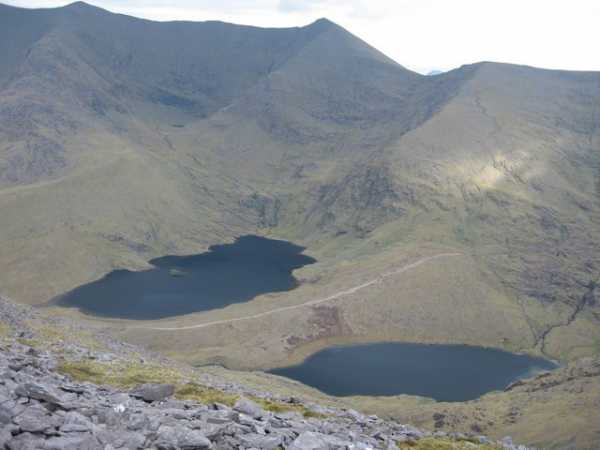
Picture: Knockbrinnea West and East from Carrauntoohils summit
jackill on Knockbrinnea West Top
by jackill
20 Jul 2005
Taken from the summit of Carrauntoohil this photo shows the two Knockbrinneas which are the two highest points in the centre of the photo.On the left you can see the steep slope up to the summit of Beenakeragh from the Hags Glen and far below on the right is the track to the devils ladder from the carpark at Lios Leadhban B (V825 875). Linkback: mountainviews.ie/summit/16/comment/1826/
Use of MountainViews is governed by conditions and a privacy policy.
Read general information about the site. Opinions in material here are not necessarily endorsed by MountainViews.
Hillwalking is a risk sport. Information in comments, walks, shared GPS tracks or about starting places may
not be accurate for example as regards safety or access permission. You are responsible for your safety and your permission to walk.
See the credits and list definitions.


 Our Facebook page.