Donation Request 2024

DONATE
Members and Supporters, the MountainViews Committee requests your help to meet the costs of the website and of other activities such as insured events or publications.
You do not have to be logged in to donate.
Features
Nearby features appear when you click the map.
Declutter tracks on map.
Place Search
Video
X
Pub: by
MacGillycuddy's Reeks Area , Cen: Reeks West Subarea
Feature count in area: 29, all in Kerry, OSI/LPS Maps: 78, EW-KNP, EW-R
Highest Place: Carrauntoohil 1038.6m

Starting Places (19) in area MacGillycuddy's Reeks:
Ballaghbeama Gap, Bridia Valley End, Cronins Yard, Gap of Dunloe Head of, Gap of Dunloe Kate K, Glashaknockbrassel Stream, Glasheenoultagh Stream, Hydro Road CP, Knocknsallagh Bridge, Lisleibane Trail Head, Lough Acoose North, Lough Acoose West, Lough Cappanlea OEC, Lough Caragh SW, Lough Fada N, Lough Reagh N, Maghanlawaun Bridia Valley, Shamrock Farmhouse B&B, Tomies Lough Leane NW

Summits & other features in area MacGillycuddy's Reeks:
Cen: Reeks West: Beenkeragh 1008.2m, Caher 1000m, Caher West Top 973.4m, Carrauntoohil 1038.6m, Cnoc Íochtair 746.3m, Hag's Tooth 662m, Knockbrinnea East Top 845.4m, Knockbrinnea West Top 852.2m, The Bones Peak 956.5m, Skregmore 847.7m, Stumpa Bharr na hAbhann 852.1m
E: Cnoc an Bhráca: Cnoc an Bhráca 728m, Cnoc na dTarbh 655m, Strickeen 440m
N: Reeks North: Knockbrack 425m, Knocknabrone Hill 353m, Skregbeg 573m
NW: Gortnagan: Gortnagan Beg 298m
SE: Reeks East: Brassel Mountain 575m, Cnoc an Chuillinn 954.6m, Cnoc an Chuillinn East Top 922.9m, Knocknapeasta 985.1m, Cnoc na Toinne 844.1m, Cruach Mhór 930.8m, Maolán Buí 968.9m, The Big Gun 939.9m
SW: Bridia: Beann Bhán 459.5m, Beendarrig 449.7m, Beann Dubh 450.5m

Note: this list of places may include island features such as summits, but not islands as such.
Rating graphic.
The Bones Peak, 956.5m Mountain Na Cnámha A name in Irish,
Place Rating ..
Na Cnámha The Bones an extra name in English, Kerry County in Munster province, in Arderin, Vandeleur-Lynam, Irish 900s Lists, Na Cnámha is the 7th highest place in Ireland.
Grid Reference V80070 84680, OS 1:50k mapsheet 78
Place visited by: 620 members, recently by: kieran117, kelleher, rhw, MartMc, orlaithfitz, PiotrR, maoris, Magic, Carolineswalsh, knightsonhikes, ConMack23, ToughSoles, muddypaws, Kaszmirek78, Iamcan
I visited this place: NO (You need to be a logged-in member for this.)
Longitude: -9.747047, Latitude: 52.001716, Easting: 80071, Northing: 84680, Prominence: 37.1m,  Isolation: 0.4km
ITM: 480046 584739
Bedrock type: Purple sandstone & siltstone, (Ballinskelligs Sandstone Formation)
Notes on name: A rocky arete between Carrauntoohil and Beenkeeragh. Previously Carrauntoohil Tooth in MV and then The Bones. Changed to have main name Na Cnámha in consultation with Kerry Mountain Rescue (Gerry Christie) and OSi to avoid confusion with The Bone a spur NE of Cnoc na Toinne
  Short or GPS IDs, 6 char: ThBnsP, 10 char: ThBnsPk

Linkback: https://mountainviews.ie/summit/7/
Gallery for The Bones Peak (Na Cnámha) and surrounds
Summary for The Bones Peak (Na Cnámha): A fine, high, rocky perch.
Summary created by Harry Goodman 2011-12-16 09:21:40
            MountainViews.ie picture about The Bones Peak (<em>Na Cnámha</em>)
Picture: On route to The Bones (centre), from Carrauntoohil.
To top out on The Bones, the highest point along the rocky arete between Carrauntoohil and Beenkeragh, one must cross part or all of the ridge. To gain access to this ridge refer to the mv short summary for Carrauntoohil. The start of the clearly defined path leading to the ridge lies about 100m SW down the shoulder from Carrauntoohil summit at A (V803 844). Drop down steeply NNW along it's line passing, on the way, the tops of Curved Gully, Central Gully and O' Shea's Gully, three established scrambling routes up from the Hag's Glen to Carrauntoohil. The climb up to The Bones (the high point of the Beenkeragh Ridge) is over rocky exposed ground and great care is needed in windy and/or wet conditions. The effort in getting there is rewarded by very fine views around the full Coomloughra Horseshoe walk, a circuit frequently used to climb Ireland's three highest mountains Caher, Carrauntoohil and Beenkeeragh, with The Bones, the fourth 3000 ft top, thrown in for good measure.
Linkback: mountainviews.ie/summit/7/comment/4767/
Member Comments for The Bones Peak (Na Cnámha)
Comment create / edit display placeholder

            MountainViews.ie picture about The Bones Peak (<em>Na Cnámha</em>)
Picture: The 'Tooth of Carrauntoohil' as seen from near Beenkeragh
john_desmond on The Bones Peak
by john_desmond 1 May 2005
This is the highest point on the ridge between Carrauntoohil and Beenkeragh. Known as the 'Tooth of Carrauntoohil' or as 'Knockoughter'. It is NOT the Hag's Tooth. The top is just above the worn path that runs along the ridge. Easy to get to if you climb up to it. Not recommended in windy weather as it has steep sides. Linkback: mountainviews.ie/summit/7/comment/1669/
Read Less
Read More

            MountainViews.ie picture about The Bones Peak (<em>Na Cnámha</em>)
Picture: The ridge to Carrauntoohil
jackill on The Bones Peak
by jackill 14 Jul 2006
We camped in Killarney on Thusday night to get an early start on Friday morning.
The plan was to take in the Coumloughra Horseshoe.We started at 9.30 am and finished at 5.30 pm.
It was a fine clear day with some of the best weather I have ever had for walking. We avoided the heat and had a lovely ,cool sea breeze for the whole day. We crossed the ridge to Carrauntoohil at 2.00 pm. The scramble down from Beenakeragh is over large blocks of rock but I didn't feel it was dangerous at any point. once on the ridge the going is on a very obvious path and the only really exposed point is where this path crosses The Bones, it is really necessary to take your time and be careful as one slip means several hundred feet of a fall.After crossing The Bones, there is a scramble up loose rock/stones on a very steep path. If you use sticks put them away before crossing this ridge , you will have to use your hands. However , this ridge must be one of the best for views in Ireland, I have seldom enjoyed a walk so much. The photo was taken on the path near the start of the ridge with The Bones in the centre just to the right of the boulders and Carrauntoohil in the left corner.The path can be seen (to the right) snaking its way through towards Carrauntoohil.It stays mostly to the right (west)of the ridge line and has three exposed parts.The longest and trickiest of these is under The Bones, where the path drops around the left(east) side for about 100 mtrs. Linkback: mountainviews.ie/summit/7/comment/1814/
Read Less
Read More

milo on The Bones Peak
by milo 16 Jul 2006
This name [Carrauntoohil Tooth] does not appear in Murray's guide nor on Sheet 79. I presume it refers to the highest point of the Beenkeeragh ridge at 959. While there I was too unrelaxed to appreciate it. Linkback: mountainviews.ie/summit/7/comment/43/
Read Less
Read More

            MountainViews.ie picture about The Bones Peak (<em>Na Cnámha</em>)
Peter Walker on The Bones Peak
by Peter Walker 12 Sep 2007
Having managed to stand up AND look through a viewfinder whilst on top of The Bones, I only succeeded in proving that exposure is really difficult to capture on camera! Ah well. As noted by others, if continuing to Carrauntoohil, the path moves over to the left side here, which seems illogical (because that's the really steep side) until you actually see it. Linkback: mountainviews.ie/summit/7/comment/2822/
Read Less
Read More

            MountainViews.ie picture about The Bones Peak (<em>Na Cnámha</em>)
Picture: The Bones rises in the centre of the Beenkeragh Ridge
Completing the 900's
by wicklore 26 Feb 2012
Up to last November I often gazed at at some of the big names of the McGillycuddy’s Reeks and wondered when I would ever get to climb them. In particular I was looking at The Big Gun & The Bones. Both are situated in somewhat precarious positions – The Big Gun lies elusively on the narrow ridge between Cruach Mhor and Cnoc Na Peiste, and requires a scramble across this ridge from either of its giant neighbours. The Bones is situated on the narrow ridge between Carrauntoohil and Beenkeeragh, and similarly requires a scramble across from either of these giants. Not being one who is particularly fond of narrow, rocky & harrowing ridges and arêtes, I knew I could be waiting for a long time before I would stand on these summits. Thanks to the MountainViews Scavvy walk last November I managed to reach the summit of The Big Gun and the rest of the 900’s in the Eastern reeks. This left only The Bones in that small list of 14 summits that poke above 3000 feet in Ireland.

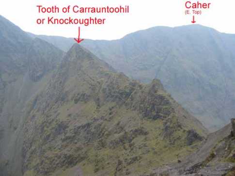
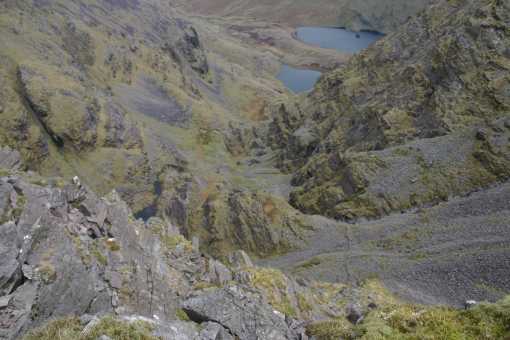
This weekend I was part of a scout group that intended to climb Carrauntoohil. MountainViews member Jackill kindly agreed to accompany us in order to look at the possibility of taking me across to The Bones and back to Carrauntoohil to rejoin the group for the homeward trek. Saturday dawned the most fabulous day ever, with clear skies and an ever present cloud inversion for miles around. The group reached Carrauntoohil via Caher in record time, and we gazed in awe at the various mountains peeking out of the cloud around and below us. Our scouts were in good shape and in good spirits so we made the decision to bring the whole group across the Beenkeragh Ridge to join me on my quest. And so it was that our scouts were the first in their Unit’s history to complete the Coumloughra Horseshoe, when we decided to carry on over Beenkeragh and return to the Hydro Road via Beenkeragh.

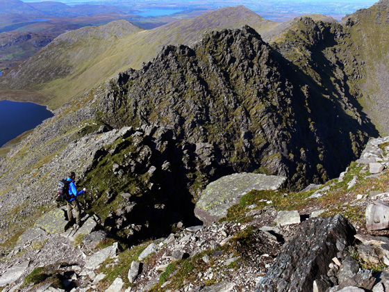
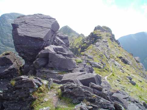
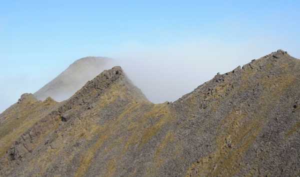
The Beenkeragh Ridge and The Bones summit are a serious challenge, and several sections require concentrated scrambling. With the support of 5 leaders (including honorary 112th Knocklyon leader Jackill) we saw our 12 hardy scouts safely across. Slow and steady was the mantra, and we saw the best of mutual assistance given and received by the scouts as they helped each other with practical tips and psychological support. They say true bravery is doing something you are scared to do, and we saw the bravest of people that day.

We were lucky to have the perfect combination of factors to make this possible – perfect weather, no wind or rain, experienced climbers and plenty of time. These are the things I would suggest are needed by those people who wish to cross the Beenkeragh Ridge and tackle The Bones, and who may be just that little bit unsure. I’ve waited several years before I got to do this climb, and I’m glad I finally got to do it with the finest bunch of people I could have wished for! Linkback: mountainviews.ie/summit/7/comment/6697/
Read Less
Read More
EDIT Point of Interest
text
Videos


Recent Contributions
x
Conditions and Info
Use of MountainViews is governed by conditions and a privacy policy.
Read general information about the site.
Opinions in material here are not necessarily endorsed by MountainViews.
Hillwalking is a risk sport. Information in comments, walks, shared GPS tracks or about starting places may not be accurate for example as regards safety or access permission. You are responsible for your safety and your permission to walk.
See the credits and list definitions.

OSi logo
OSNI/LPS logo
Open Street Map
(Various variations used.)
British summit data courtesy:
Database of British & Irish Hills