Members and Supporters, the MountainViews Committee requests your help to meet the costs of the website and of other activities such as insured events or publications.
Feature count in area: 29, all in Kerry,
OSI/LPS Maps: 78, EW-KNP, EW-R
Highest Place: Carrauntoohil 1038.6m
Starting Places (19) in area MacGillycuddy's Reeks: Ballaghbeama Gap, Bridia Valley End, Cronins Yard, Gap of Dunloe Head of, Gap of Dunloe Kate K, Glashaknockbrassel Stream, Glasheenoultagh Stream, Hydro Road CP, Knocknsallagh Bridge, Lisleibane Trail Head, Lough Acoose North, Lough Acoose West, Lough Cappanlea OEC, Lough Caragh SW, Lough Fada N, Lough Reagh N, Maghanlawaun Bridia Valley, Shamrock Farmhouse B&B, Tomies Lough Leane NW
Summits & other features in area MacGillycuddy's Reeks: Cen: Reeks West: Beenkeragh 1008.2m, Caher 1000m, Caher West Top 973.4m, Carrauntoohil 1038.6m, Cnoc Íochtair 746.3m, Hag's Tooth 662m, Knockbrinnea East Top 845.4m, Knockbrinnea West Top 852.2m, The Bones Peak 956.5m, Skregmore 847.7m, Stumpa Bharr na hAbhann 852.1m E: Cnoc an Bhráca: Cnoc an Bhráca 728m, Cnoc na dTarbh 655m, Strickeen 440m N: Reeks North: Knockbrack 425m, Knocknabrone Hill 353m, Skregbeg 573m NW: Gortnagan: Gortnagan Beg 298m SE: Reeks East: Brassel Mountain 575m, Cnoc an Chuillinn 954.6m, Cnoc an Chuillinn East Top 922.9m, Knocknapeasta 985.1m, Cnoc na Toinne 844.1m, Cruach Mhór 930.8m, Maolán Buí 968.9m, The Big Gun 939.9m SW: Bridia: Beann Bhán 459.5m, Beendarrig 449.7m, Beann Dubh 450.5m
Note: this list of places may include island features such as summits, but not
islands as such.
Cruach Mhór, 930.8mMountain
Place Rating ..
(Ir. Cruach Mhór [OSI 1:25,000], 'big stack'), Cruach Bheag, Kerry County in Munster province, in Arderin, Vandeleur-Lynam, Irish Best Hundred, Irish 900s Lists, Cruach Mhór is the 11th highest place in Ireland.
Grid Reference V84076 84820,
OS 1:50k mapsheet 78 Place visited by: 548members, recently by: rhw, MartMc, orlaithfitz, maoris, Magic, Carolineswalsh, ConMack23, Beti13, ToughSoles, muddypaws, Kaszmirek78, Padraigin, abeach, Krzysztof_K, markwallace
I visited this place: NO (You need to be a logged-in member for this.)
Longitude: -9.688784, Latitude: 52.003823, Easting: 84077, Northing: 84820,
Prominence: 34m, Isolation: 0.3km ITM: 484052 584879 Bedrock type: Well-bedded grey sandstone, (Lough Acoose Sandstone Formation) Notes on name: The summit has a grotto built by a local farmer who dragged the cement, sand and water up from his home in Ballyledder on his back. There is also a lower peak to the east known as An Chruach Bheag (TH). Both have the sharply pointed shape associated with peaks called cruach, and this also accounts for the Irish name of the range: na Cruacha Dubha (Mhic Giolla Mo Chuda).
Short or GPS IDs, 6 char: CrchMh, 10 char: CrchMhór Linkback: https://mountainviews.ie/summit/11/
Gallery for Cruach Mhór and surrounds
Summary
for Cruach Mhór :
The Grotto at the end of the world
Summary created by jackill
2011-06-30 20:13:41
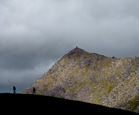
Picture: From Cnoc an Chuillinn
Park in Cronins Yard Cronins (V83665 87340) where there is pay parking (2€ per day) and room for 50 cars.
There is also a seasonal Tea room and toilets.Walk through the gate passing a wall of plaques to your left , follow the track through another gate and over a stream. The path becomes loose pebbles, turn left just before the first bridge crossing to a stile at A (V83070 86411). Follow the stream edge from here before turning off to the left aiming for a noticable line of rocks that descend from Lough Cummeenapeasta. Follow this line up to the Lough.
Ascend eastwards over large rocks, it is easier to use these to step on rather than picking your way around them on the scant loose soil.
The summit is marked by a large grotto with a brass statue of the Virgin and Child.
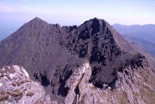
Cruach Mhór coming up the ridge from Cruach Bheag and Cnoc an Bhraca.Started at Cronins Farmyard and followed the Reeks Ridge walk as described in The Lonely Planet guide "Walking in Ireland". Started up Cruach Mhór from B (V843 859) just west of Locha Chaca (look out for the green grassy slope) to reach the area where the photo was taken from. Then on over the ridge to Maolan Bui taking in The Big Gun and Cnoc Na peiste. The Big Gun is absolutely the most challenging climb I have done in Ireland - we crossed in calm weather during a dry August afternoon - if you were to attempt it in more difficult weather/wind I think ice axes/ropes etc. would be needed. When ever you attempt it a good head for heights and good route finding skills will be needed. However you can avoid the worst of it by dropping down after Cruach Mhor to the north side of the ridge - note you will have to go down about 150 mtrs to avoid the blocks of rock sweeping down the sides - and finding a fairly distinct track around to the col before Cnoc na Peiste. Linkback: mountainviews.ie/summit/11/comment/1147/
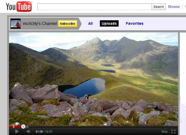
An Cruach Mhor is a shapely mountain that is the main gateway to the eastern Reeks from Cronin's yard. Its a real Top Ten classic, as is its next of kin, The Big Gun. I wondered if I was truly "up to it" when I made my plans for the great event earlier in the year. I would have loved to have had the benefit of the mcrtchly / kernowclimber YouTube film "MacGillycuddy's Reeks Traverse Part One". I strongly recommend this film as part of your preparations.. Our friends have really done a superb job in capturing the stupendous terrain and staggering views. I hesitate to quibble about the choice of background music. The initial ballad simply dosen't appeal to me...no matter how apparently apt it may seem for reasons of local references. To me this mountain requires majestic music to resonate with its greatness! But fear not! The gruesome "come all ye" is soon replaced by Holst's Mars (from The Planets) Please be sure to see
Cruach Mhor is beautiful peak that is a worthy day's objective in itself or as the first major triumph of a bigger mountain day. This lofty perch topped by an impressive grotto[built by a local gentleman] , offers superb views in all directions. The view across the hags glen towards Corran Tuathail encapsulates what these mountains are all about. The ridge that beckons towards Cnoc na Peiste is mouthwatering. Enjoy the picture of the Big Gun I think it captures the spirit of the place. Linkback: mountainviews.ie/summit/11/comment/813/
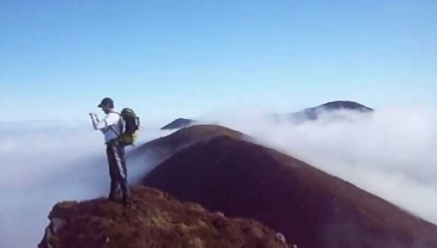
Dom Divilly says, in his intro:
"A beautiful route up from Eisc an Bharca gully to the summit of Cruach Mor then over the Big Gun to Cnoc na Peiste and down the ridge to the lake below then back to Cronins Yard,the gateway to the Reeks. John and Esther Cronin will look after you with tea,coffee,sandwiches,fruit cake,scones or lovely homemade soup.You can also purchase maps,books,walking poles and rain gear along with many other bits and bobs. Freshen up after a day hiking with a shower with complimentary towels provided by Cronins yard."
The film shows Divilly's crew in the perfect silence of a cloud inversion, figuring out where to go, and heading up a gully until they emerge above the cloud in the glorious sunshine. What you end up with is the higher Reeks floating like islands in a sea of dense cloud. Linkback: mountainviews.ie/summit/11/comment/17854/
Read Less
Read More
John Finn on Cruach Mhór
by John Finn
22 Aug 2004
The arete between Cruach Mhor (to the far left) and Cnoc na Peiste (from where the photo was taken) on the Eastern Reeks. This is a heart-stopping place at times - especially in poor weather! The best way across is to keep to the skyline ...if you've got the nerve. Linkback: mountainviews.ie/summit/11/comment/1127/
Use of MountainViews is governed by conditions and a privacy policy.
Read general information about the site. Opinions in material here are not necessarily endorsed by MountainViews.
Hillwalking is a risk sport. Information in comments, walks, shared GPS tracks or about starting places may
not be accurate for example as regards safety or access permission. You are responsible for your safety and your permission to walk.
See the credits and list definitions.


 Our Facebook page.