Members and Supporters, the MountainViews Committee requests your help to meet the costs of the website and of other activities such as insured events or publications.
Feature count in area: 29, all in Kerry,
OSI/LPS Maps: 78, EW-KNP, EW-R
Highest Place: Carrauntoohil 1038.6m
Starting Places (19) in area MacGillycuddy's Reeks: Ballaghbeama Gap, Bridia Valley End, Cronins Yard, Gap of Dunloe Head of, Gap of Dunloe Kate K, Glashaknockbrassel Stream, Glasheenoultagh Stream, Hydro Road CP, Knocknsallagh Bridge, Lisleibane Trail Head, Lough Acoose North, Lough Acoose West, Lough Cappanlea OEC, Lough Caragh SW, Lough Fada N, Lough Reagh N, Maghanlawaun Bridia Valley, Shamrock Farmhouse B&B, Tomies Lough Leane NW
Summits & other features in area MacGillycuddy's Reeks: Cen: Reeks West: Beenkeragh 1008.2m, Caher 1000m, Caher West Top 973.4m, Carrauntoohil 1038.6m, Cnoc Íochtair 746.3m, Hag's Tooth 662m, Knockbrinnea East Top 845.4m, Knockbrinnea West Top 852.2m, The Bones Peak 956.5m, Skregmore 847.7m, Stumpa Bharr na hAbhann 852.1m E: Cnoc an Bhráca: Cnoc an Bhráca 728m, Cnoc na dTarbh 655m, Strickeen 440m N: Reeks North: Knockbrack 425m, Knocknabrone Hill 353m, Skregbeg 573m NW: Gortnagan: Gortnagan Beg 298m SE: Reeks East: Brassel Mountain 575m, Cnoc an Chuillinn 954.6m, Cnoc an Chuillinn East Top 922.9m, Knocknapeasta 985.1m, Cnoc na Toinne 844.1m, Cruach Mhór 930.8m, Maolán Buí 968.9m, The Big Gun 939.9m SW: Bridia: Beann Bhán 459.5m, Beendarrig 449.7m, Beann Dubh 450.5m
Note: this list of places may include island features such as summits, but not
islands as such.
Cnoc an Chuillinn East Top, 922.9mMountain Cnoc an Chuillinn (mullach thoir) A name in Irish,
Place Rating ..
For origin of name, see Cnoc an Chuillinn., Kerry County in Munster province, in Arderin Beg, Vandeleur-Lynam, Irish 900s Lists, Cnoc an Chuillinn East Top is the 13th highest place in Ireland.
Grid Reference V82803 83431,
OS 1:50k mapsheet 78 Place visited by: 492members, recently by: kieran117, kelleher, rhw, MartMc, nupat, NualaB, maoris, Magic, Carolineswalsh, ConMack23, Beti13, ToughSoles, muddypaws, noelcurt, Kaszmirek78
I visited this place: NO (You need to be a logged-in member for this.)
Longitude: -9.706852, Latitude: 51.991075, Easting: 82803, Northing: 83431,
Prominence: 21m, Isolation: 0.5km ITM: 482778 583490 Bedrock type: Well-bedded grey sandstone, (Lough Acoose Sandstone Formation) Notes on name: Located mid-way between Cnoc an Chuillinn itself and Maolán Buí. Previously L Coimín Móir Mtn in MV.
Short or GPS IDs, 6 char: Cnc923, 10 char: CncanChlnE Linkback: https://mountainviews.ie/summit/12/
Gallery for Cnoc an Chuillinn East Top (Cnoc an Chuillinn (mullach thoir)) and surrounds
Summary
for Cnoc an Chuillinn East Top (Cnoc an Chuillinn (mullach thoir)):
Lofty bump on Reeks ridge.
Summary created by simon3
2016-06-12 07:38:11
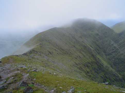
Picture: Cnoc an Chuillinn East Top is skyline left of centre.
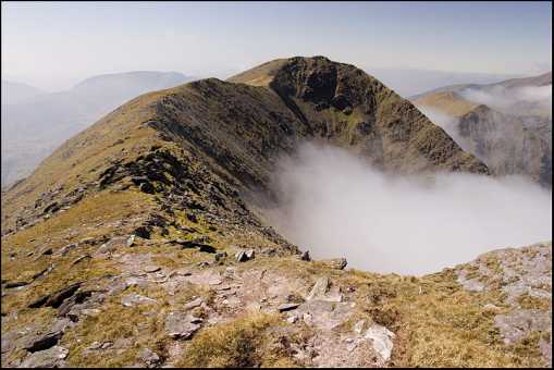
Cnoc an Chuillinn East Top is essentially a minor bump in the middle of the MacGillycuddy's Reeks. Usually it is visited while walking the ridge between Maolán Buí and Cnoc an Chuillinn both of which are slightly higher. Like everywhere on the ridge the views and exposure are great.
Lough Comin Moir Mountain in the centre of the photo as as viewed from the summit of Maolan Bui. The summit of Cnoc an Chuillin is just visible in the clouds to the right of centre.
On the extreme left you can see the track which leads all the way back to the Devils ladder and points beyond if you've got the energy. Linkback: mountainviews.ie/summit/12/comment/1143/
Use of MountainViews is governed by conditions and a privacy policy.
Read general information about the site. Opinions in material here are not necessarily endorsed by MountainViews.
Hillwalking is a risk sport. Information in comments, walks, shared GPS tracks or about starting places may
not be accurate for example as regards safety or access permission. You are responsible for your safety and your permission to walk.
See the credits and list definitions.


 Our Facebook page.