Members and Supporters, the MountainViews Committee requests your help to meet the costs of the website and of other activities such as insured events or publications.
MacGillycuddy's ReeksArea, Cen: Reeks West
Subarea
Feature count in area: 29, all in Kerry,
OSI/LPS Maps: 78, EW-KNP, EW-R
Highest Place: Carrauntoohil 1038.6m
Starting Places (19) in area MacGillycuddy's Reeks: Ballaghbeama Gap, Bridia Valley End, Cronins Yard, Gap of Dunloe Head of, Gap of Dunloe Kate K, Glashaknockbrassel Stream, Glasheenoultagh Stream, Hydro Road CP, Knocknsallagh Bridge, Lisleibane Trail Head, Lough Acoose North, Lough Acoose West, Lough Cappanlea OEC, Lough Caragh SW, Lough Fada N, Lough Reagh N, Maghanlawaun Bridia Valley, Shamrock Farmhouse B&B, Tomies Lough Leane NW
Summits & other features in area MacGillycuddy's Reeks: Cen: Reeks West: Beenkeragh 1008.2m, Caher 1000m, Caher West Top 973.4m, Carrauntoohil 1038.6m, Cnoc Íochtair 746.3m, Hag's Tooth 662m, Knockbrinnea East Top 845.4m, Knockbrinnea West Top 852.2m, The Bones Peak 956.5m, Skregmore 847.7m, Stumpa Bharr na hAbhann 852.1m E: Cnoc an Bhráca: Cnoc an Bhráca 728m, Cnoc na dTarbh 655m, Strickeen 440m N: Reeks North: Knockbrack 425m, Knocknabrone Hill 353m, Skregbeg 573m NW: Gortnagan: Gortnagan Beg 298m SE: Reeks East: Brassel Mountain 575m, Cnoc an Chuillinn 954.6m, Cnoc an Chuillinn East Top 922.9m, Knocknapeasta 985.1m, Cnoc na Toinne 844.1m, Cruach Mhór 930.8m, Maolán Buí 968.9m, The Big Gun 939.9m SW: Bridia: Beann Bhán 459.5m, Beendarrig 449.7m, Beann Dubh 450.5m
Note: this list of places may include island features such as summits, but not
islands as such.
Caher, 1,000.0mMountain Cathair A name in Irish,
Place Rating ..
(Ir. Cathair [OSI 1:25,000], 'stone fort'), Kerry County in Munster province, in Arderin, Vandeleur-Lynam, Irish 900s Lists, Caher is the third highest mountain in Ireland. Caher is the third highest point in county Kerry.
Grid Reference V79261 83891,
OS 1:50k mapsheet 78 Place visited by: 1037members, recently by: kieran117, kelleher, rhw, MartMc, BarnabyNutt, orlaithfitz, maoris, PiotrR, Magic, Carolineswalsh, knightsonhikes, CianDavis, freelanb, Shaina, ToughSoles
I visited this place: NO (You need to be a logged-in member for this.)
Longitude: -9.758549, Latitude: 51.994449, Easting: 79261, Northing: 83891,
Prominence: 99.8m, Isolation: 0.3km ITM: 479237 583950 Bedrock type: Purple sandstone & siltstone, (Ballinskelligs Sandstone Formation) Notes on name: According to Ó Cíobháin, this mountain is also known as Cathair na Féinne, 'stone fort of the Fianna'.
Short or GPS IDs, 6 char: Caher, 10 char: Caher Linkback: https://mountainviews.ie/summit/3/
Gallery for Caher (Cathair) and surrounds
Summary
for Caher (Cathair):
Two for the price of one!
Summary created by Harry Goodman
2011-12-21 19:13:17
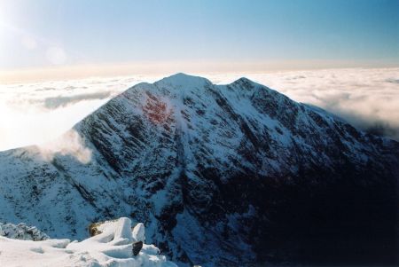
Picture: Looking SW to Cahir from Carrauntoohil. mv
Park off road near A (V77150 87050), the start of the concrete Hydro Road leading up to L. Iochtair. Although a bit of a slog it is a sure way to the Loch B (V777 856) and the real start of the climb up to Caher. Keeping the Loch to the left, head S over Pt. 442 to gain the NW spur C (V776 852) of Caher. Head up left (SSE) initially over tussocky grass interspersed with some stoney ground and then, nearer the first top (Caher W Top) over steeper and much rockier ground. From the summit cairn of CWT drop down a short way (less than 100m) ESE to a grass and stone covered saddle before climbing up in the same direction to Caher summit a further 200m along. This top is excellent both for a close up view of the main mountains in the Reeks and as the start of a high level route to Carrauntoohil. The route also has the advantage that it passes over Cahir W Top on the way and provides an opportunity to bag it en route.
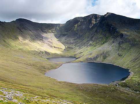
My son and I did the Coomloughra Horseshoe on 30th August starting at Lough Acoose. We parked at the eastern end of the lake by a layby where there is a waymarker for the Kerry Way. If there is a distinct path up to the lower slopes of Caher we could not find it and it was a bit of a slog over damp ground before we got on to the mountain proper. From there on it was an enjoyable walk up the side of Caher looking down into Coomloughra Glen and as we walked the clouds began to lift. We reached the summit of Carrauntoohill after three hours of a fairly leisurely
pace and one long stop. Visibility was good and there was a very moderate wind so we decided to continue across the ridge to Beenkeragh. This ridge tends to frighten a lot of people off what with
descriptions of it being a knife edge and the like. It ain't that bad and certainly within the competence of anyone who can get the summit of Carraun in the first place. It is pretty exposed in
places and so is probably best avoided in poor weather conditions. Keep to the skyline as much as possible but if your nerve fails you you can drop down a bit to the side in the tricky parts. The latter part of it is a pleasant ridge walk and then it's a short and easy scramble up to the summit of Beenkeragh. The descent from Beenkeragh down to the Skregmore ridge requires care as its stewn with boulders. From there on it's a pleasant walk across the Skregmore ridge. We descended the steep slopes down to the old hydro works at Lough Eighter. Then it was another hard slog across damp and marhsy ground in places until we reached the car. It took us
seven and a half hours in total. In retrospect I think it's better not to start at Lough Acoose and to take the old hydro path (clearly marked on the OS maps) instead. I prefer to do it CCW even though it goes against the principle of sharp ascent and easy descent. Either way the hydro path
affords the easiest approach and finish for the walk, in my opinion. All in all the Coomloughra Horseshoe is a physically challenging day out and provides some of the most spectacular mountain scenery in Ireland. The photo, taken on the lower slopes of Skregmore, shows the Coomloughra Glen with Caher on the right and Carrauntoohill on the left. Linkback: mountainviews.ie/summit/3/comment/1155/
Read Less
Read More
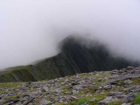
Picture: Caher's exposed ridge.
simon3 on Caher
by simon3
6 Jan 2006
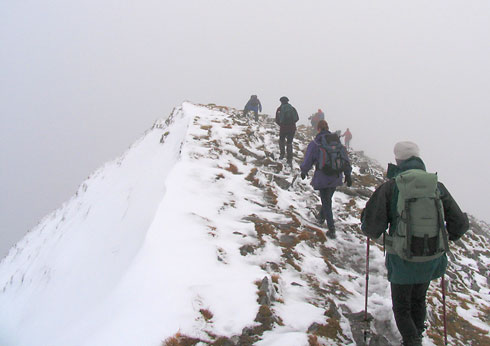
Caher is at just over 1000m and as you move east from it towards Carrauntoohil you will stay at over 900m for nearly 500m. This photo shows what it looks like in typical winter conditions, the snow starting to accumulate into a cornice. Linkback: mountainviews.ie/summit/3/comment/2123/
Read Less
Read More
Fergal Meath on Caher
by Fergal Meath
24 Jan 2007
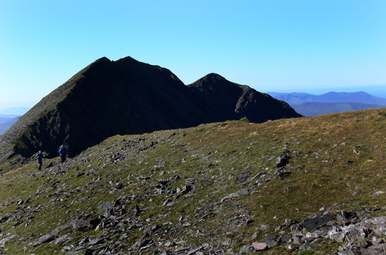
Encountered the magnificent Caher whilst doing the Coomloughra horseshoe ascent to Carrauntoohil. The wind was a bit high so the group decided not to do the Beenkeragh ridge but instead we descended by the scree slope into Coomloughra glen. Would not recommend this descent as we ran into steep ground and had to negotiate a couple of crags. The peak to the left is Caher with its West top to the right as seen from the ridge across to Carrauntohil. Linkback: mountainviews.ie/summit/3/comment/2593/
Read Less
Read More
sliabh on Caher
by sliabh
22 Jan 2004
This is a shot of Caher taken from Carrauntoohil on 29/12/2003. It was a fabulous day to do the Cooloughra Horseshoe. We had snow on the ground and an inversion layer formed as we got higher.
There are more pictures at: http://sliabh.net/images/ireland/xmas2003/images.php
We did the horseshoe up Beenkeragh and down Caher so we didn't have the slog up to Caher. Its much more pleasant as a descent Linkback: mountainviews.ie/summit/3/comment/821/
Read Less
Read More
Picture: Ridge to Caher from Carrauntoohil
wicklore on Caher
by wicklore
10 Sep 2008
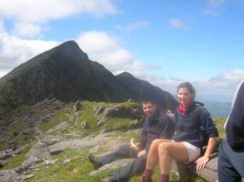
A tourist I spoke to recently talked about seeing Ireland as a mystical land, with verdant glens and misty heights. He thought that there is a essence to the Irish landscape not found elsewhere. This photo I took of the ridge leading up to Caher from Carrauntoohil perhaps captures some of that essence. Linkback: mountainviews.ie/summit/3/comment/3301/
Use of MountainViews is governed by conditions and a privacy policy.
Read general information about the site. Opinions in material here are not necessarily endorsed by MountainViews.
Hillwalking is a risk sport. Information in comments, walks, shared GPS tracks or about starting places may
not be accurate for example as regards safety or access permission. You are responsible for your safety and your permission to walk.
See the credits and list definitions.


 Our Facebook page.