Members and Supporters, the MountainViews Committee requests your help to meet the costs of the website and of other activities such as insured events or publications.
Feature count in area: 29, all in Kerry,
OSI/LPS Maps: 78, EW-KNP, EW-R
Highest Place: Carrauntoohil 1038.6m
Starting Places (19) in area MacGillycuddy's Reeks: Ballaghbeama Gap, Bridia Valley End, Cronins Yard, Gap of Dunloe Head of, Gap of Dunloe Kate K, Glashaknockbrassel Stream, Glasheenoultagh Stream, Hydro Road CP, Knocknsallagh Bridge, Lisleibane Trail Head, Lough Acoose North, Lough Acoose West, Lough Cappanlea OEC, Lough Caragh SW, Lough Fada N, Lough Reagh N, Maghanlawaun Bridia Valley, Shamrock Farmhouse B&B, Tomies Lough Leane NW
Summits & other features in area MacGillycuddy's Reeks: Cen: Reeks West: Beenkeragh 1008.2m, Caher 1000m, Caher West Top 973.4m, Carrauntoohil 1038.6m, Cnoc Íochtair 746.3m, Hag's Tooth 662m, Knockbrinnea East Top 845.4m, Knockbrinnea West Top 852.2m, The Bones Peak 956.5m, Skregmore 847.7m, Stumpa Bharr na hAbhann 852.1m E: Cnoc an Bhráca: Cnoc an Bhráca 728m, Cnoc na dTarbh 655m, Strickeen 440m N: Reeks North: Knockbrack 425m, Knocknabrone Hill 353m, Skregbeg 573m NW: Gortnagan: Gortnagan Beg 298m SE: Reeks East: Brassel Mountain 575m, Cnoc an Chuillinn 954.6m, Cnoc an Chuillinn East Top 922.9m, Knocknapeasta 985.1m, Cnoc na Toinne 844.1m, Cruach Mhór 930.8m, Maolán Buí 968.9m, The Big Gun 939.9m SW: Bridia: Beann Bhán 459.5m, Beendarrig 449.7m, Beann Dubh 450.5m
Note: this list of places may include island features such as summits, but not
islands as such.
Maolán Buí, 968.9mMountain
Place Rating ..
(Ir. Maolán Buí [OSI 1:25,000], 'yellow/golden round knoll'), Top of the Bone, Kerry County in Munster province, in Arderin, Vandeleur-Lynam, Irish Best Hundred, Irish 900s Lists, Maolán Buí is the 6th highest place in Ireland.
Grid Reference V83213 83815,
OS 1:50k mapsheet 78 Place visited by: 573members, recently by: kieran117, kelleher, rhw, MartMc, orlaithfitz, maoris, Magic, Carolineswalsh, Beti13, ToughSoles, muddypaws, Kaszmirek78, Lucy.boland, DeirdreM, chelman7
I visited this place: NO (You need to be a logged-in member for this.)
Longitude: -9.701017, Latitude: 51.994611, Easting: 83213, Northing: 83815,
Prominence: 38m, Isolation: 0.5km ITM: 483188 583874 Bedrock type: Well-bedded grey sandstone, (Lough Acoose Sandstone Formation) Notes on name: Sometimes called Bearna Rua. The ridge known as the Bone descends NW from this peak. This is a good escape route off the eastern Reeks.
Short or GPS IDs, 6 char: MlánBí, 10 char: Maolán Buí Linkback: https://mountainviews.ie/summit/6/
Gallery for Maolán Buí and surrounds
Summary
for Maolán Buí :
High, central Eastern reek with easy access.
Summary created by markmjcampion, march-fixer
2021-02-07 20:25:23
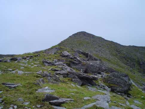
Picture: Maolán Buí from the NE.
Maolán Buí is part of the Eastern Reeks ridge high above the Hag's Glen. It's a benign top in comparison to some of its NE neighbours and the underfoot conditions are good. That said, there's very steep ground to the W, SE and N so much care is needed to stay on track in poor weather conditions. The views from the top are panoramic, weather permitting! It is magical to look W across the glen and soak in the majesty of Carrauntoohil standing proud among its fellow 1,000m+ summits and S to the Black Valley and Dunkerron mountains.
N. Park at Cronin's Yard [Cronins (V83608 87337)] or Lisleibane [Lilybane (V82707 87311)] and, unless doing MB as part of the Easterm Reeks' ridge, head into the Hag's Glen as far as approx. A (V82303 85034) and from here head SE up The Bone. The route is fairly obvious and as you ascend it becomes narrower and the track more obvious. If taking this route down be very careful to keep right at around B (V83100 83899). Allow 2hrs+
N. This mountain lies on the Eastern Reeks ridge. If approaching from the NE it's an easy climb in the wake of much more arduous terrain. It's also straight forward from the SW.
SE. Park with care near Shamrock BB (V85642 82670) and strike out NW up a long, well-defined spur to Feabrahy. Expect steeper ground thereafter - a slog will take you to the col to the NE of the summit. Allow 2hrs+
Notable tracks incl. track/4190. track/2304 and track/3790.
Climbed her on 2-Jan-2009 with a group of 10. Started out in good weather and visibility in Cronins yard. Made the summit moving nicely in 2.5 hours. Conditions on top were 5m visibility in freezing conditions. Had planned to head west and descend via the Zig-zags. Pulled back from this after travelling about 200m with some party members very cold at this stage. Even though I had been down The Bone in good conditions before somehow we drifted off the route down and ended up very west (left) of the intended route. Moral: be very careful up high when conditions detiorate and always keep consulting the compass to ensure you are on the right bearing, go slow and dont rush map reading no matter how cold everyone is. We got everyone down safely by descending slowly and carefully, but lesson learned (again!) Linkback: mountainviews.ie/summit/6/comment/3502/
Read Less
Read More
jackill on Maolán Buí
by jackill
29 Aug 2004
The summit of Maolan Bui as viewed from The Bone. We tacked the 'Reeks Ridge in August 2004 and descended from Maolan Bui via The Bone into the Hags Glen - much better than the Devils Ladder. Linkback: mountainviews.ie/summit/6/comment/1144/
Read Less
Read More
jackill on Maolán Buí
by jackill
29 Aug 2004
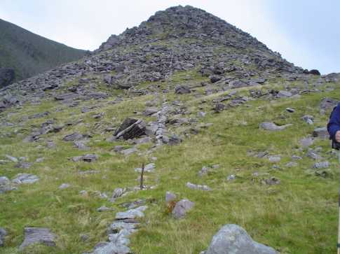
The way down The Bone is marked by a line of stones with rusted iron fence posts at regular intervals. the photo shows part of this line on the lower slopes of The Bone but it reaches most of the way to the top of the mountain. It could be a useful aid in bad conditions. Please note the track down is slightly to the west of the line of stones but if you can stay within 5-6 meters of it you won't go far wrong. Linkback: mountainviews.ie/summit/6/comment/1151/
Read Less
Read More
Picture: View down The Bone
dbloke on Maolán Buí
by dbloke
4 Jan 2009
incawest has beaten me to it, but we somehow ended up on the same false path down the Bone. We did the reverse route on 03 Jan 2009, up the zig-zags and down The Bone, but we were toasty warm thanks to the flask of coffee and multiple fleece layers. The summit of Maolán Buí was clear on our first arrival, but after a detour to bag Cnoc na Péiste the mist had descended on our return. According to my GPS we started off down the right path, but veered off at C (V831 839). This path just gets steeper and steeper. It must disappear over the cliffs below at some point. Once we realised our dilemma we made a trouser-staining traverse back to the ridge and picked up the proper path. Linkback: mountainviews.ie/summit/6/comment/3504/
Read Less
Read More
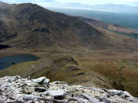
Picture: The summit from the east.
Easily Reached From Knocknapeasta
by Aidy
17 Jul 2015
This was our fourth summit of the day, all over 900m on a traverse of the Eastern Reeks starting with Cruach Mhor, and the easiest of the day so far. There had been steep climbs and scrambling, with some dangerous stages in the earlier part of the walk, particularly in the bad weather we'd had. Now however, it was a short walk up a gentle incline to Maolan Bui from Knocknapeasta. There were no sheer drops to our sides either, and we were glad of the chance for a more relaxed stretch. Linkback: mountainviews.ie/summit/6/comment/18200/
Use of MountainViews is governed by conditions and a privacy policy.
Read general information about the site. Opinions in material here are not necessarily endorsed by MountainViews.
Hillwalking is a risk sport. Information in comments, walks, shared GPS tracks or about starting places may
not be accurate for example as regards safety or access permission. You are responsible for your safety and your permission to walk.
See the credits and list definitions.


 Our Facebook page.