This website uses cookies, which are small text files that the website puts on your device to facilitate operation. Cookies help us provide a better service to you. They are used to track general user traffic information and to help the website function properly.
Feature count in area: 29, all in Kerry,
OSI/LPS Maps: 78, EW-KNP, EW-R
Highest Place: Carrauntoohil 1038.6m
Starting Places (19) in area MacGillycuddy's Reeks: Ballaghbeama Gap, Bridia Valley End, Cronins Yard, Gap of Dunloe Head of, Gap of Dunloe Kate K, Glashaknockbrassel Stream, Glasheenoultagh Stream, Hydro Road CP, Knocknsallagh Bridge, Lisleibane Trail Head, Lough Acoose North, Lough Acoose West, Lough Cappanlea OEC, Lough Caragh SW, Lough Fada N, Lough Reagh N, Maghanlawaun Bridia Valley, Shamrock Farmhouse B&B, Tomies Lough Leane NW
Summits & other features in area MacGillycuddy's Reeks: Cen: Reeks West: Beenkeragh 1008.2m, Caher 1000m, Caher West Top 973.4m, Carrauntoohil 1038.6m, Cnoc Íochtair 746.3m, Hag's Tooth 662m, Knockbrinnea East Top 845.4m, Knockbrinnea West Top 852.2m, The Bones Peak 956.5m, Skregmore 847.7m, Stumpa Bharr na hAbhann 852.1m E: Cnoc an Bhráca: Cnoc an Bhráca 728m, Cnoc na dTarbh 655m, Strickeen 440m N: Reeks North: Knockbrack 425m, Knocknabrone Hill 353m, Skregbeg 573m NW: Gortnagan: Gortnagan Beg 298m SE: Reeks East: Brassel Mountain 575m, Cnoc an Chuillinn 954.6m, Cnoc an Chuillinn East Top 922.9m, Knocknapeasta 985.1m, Cnoc na Toinne 844.1m, Cruach Mhór 930.8m, Maolán Buí 968.9m, The Big Gun 939.9m SW: Bridia: Beann Bhán 459.5m, Beendarrig 449.7m, Beann Dubh 450.5m
Note: this list of places may include island features such as summits, but not
islands as such.
Brassel Mountain, 575mMountain Cnoc Breasail A name in Irish,
Place Rating ..
(Ir. Cnoc Breasail [TH] or Breasail [OSI 1:25,000], 'hill of raddle'), Kerry County in Munster province, in Arderin Lists, Brassel Mountain is the 350th highest place in Ireland. Brassel Mountain is the second most southerly summit in the MacGillycuddy's Reeks area.
Grid Reference V83049 82269,
OS 1:50k mapsheet 78 Place visited by: 94members, recently by: mountainmike, Krzysztof_K, abcd, millsd1, Geo, Taisce, chelman7, daitho9, Superterence, eoghancarton, Ulsterpooka, annem, muddyboots, Fergalh, eamonoc
I visited this place: NO (You need to be a logged-in member for this.)
Longitude: -9.702876, Latitude: 51.980689, Easting: 83049, Northing: 82269,
Prominence: 50m, Isolation: 1.2km ITM: 483024 582329 Bedrock type: Green sandstone & purple siltstone, (Glenflesk Chloritic Sandstone Formation) Notes on name: The Ordnance Survey Name Book suggests that Breasal is a man's name, but a connection with raddle, the red dye traditionally used to mark sheep, seems more likely.
Short or GPS IDs, 6 char: BrslMn, 10 char: BrslMntn Linkback: https://mountainviews.ie/summit/317/
Gallery for Brassel Mountain (Cnoc Breasail) and surrounds
No summary yet for this place
.
Member Comments for
Brassel Mountain (Cnoc Breasail)
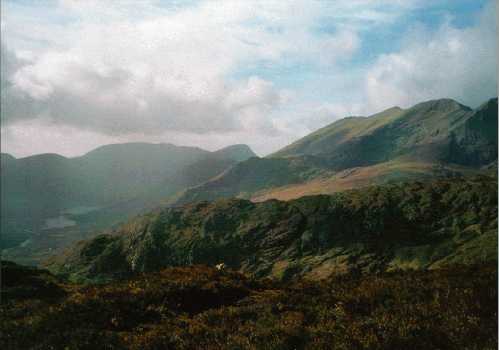
Brassel is a pretty nondescript lump that is usually a stepping stone on the way up to the main Reeks ridge. It does however have one great thing going for it, there is a lovely scramble to be had at the start of the climb.Walk in past Feabrahy and head up towards Lough Callee. Before you reach the lake head for the obvious rocky buttress on the right of an ill defined gully. As you get nearer it looks a bit intimidating but don't despair, the rock has lots of ledges and positive holds. I would grade it as a scramble 2 or 3. When you reach the top there is a small drop and then a steep push of about 1300 ft to reach the main ridge. Turn right and enjoy the beautiful walk to Cnoc na Peiste. Retrace your steps about 200 yards and descend steeply on a southeast heading to the 600 meter contour. Down then an easy gully to Lough Googh and head for the hairpin on Black Valley road. A lovely day. The pic isn't great but it shows Brassel low and just left of centre with Feabrahy centre and of course the main Reeks ridge as seen from Drishana. Linkback: mountainviews.ie/summit/317/comment/824/
Read Less
Read More
A varied trip to this summit
by kkendellen
18 Aug 2019
Just back from a great weekend in the Reeks. A group of us decided to go for a few more challenging routes than our previous trips to the Kingdom, with as much scrambling potential as possible. After the usual torture of Friday night traffic from Dublin to Kerry, started fresh on Saturday morning at the foot of Brassel mountain.
The plan was to climb the easterly ridge of Brassel, then join the main Reeks ridge and continue over the Big Gun and eventually down Drishana back to the car. From the road the scrambling potential on Brassel looked hugely inviting and sustained. It did not disappoint!! Great srambling on dry, super grippy rock with loads of options for routefinding. The views of Lough Calee and the Reeks ridge were fantastic all along with a nice bit of exposure to keep it all very interesting. The whole climb to the summit was completely engrossing and a well earned break at the summit was had to savour the great views across the Reeks ridge.
Unfortunately at this point the cloud cover descended to about 600-700m and brought with it driving rain and a wind that you could barely stand upright in on the Reeks ridge. Obviously the chances of crossing the Big Gun were diminishing rapidly! We continued along the ridge in the hope that the wind would push off the rain and clouds but to no avail. The route was cut short after a brief discussion and the dreaded compass was dragged from the rucksack. We naved off the ridge coming down Feabrahy and back to the road to the car. Altogether though it was a fine days route with great scrambling and views before the weather closed in. The full intended route will definitely be done in the future ( and hopefully in weather where there will be a better view than the inside of a goretex hood! ).
A word of caution though, when we got back to Dublin we found two people had been rescued by mountain rescue earlier in the morning that we started the climb, after both fell approx 150ft on Brassel. It may not be the highest mountain in the Reeks but there are all levels of scrambling difficulty and exposure on it. Pick your route carefully and be sure you're comfortable with the level of moves you decide on. Linkback: mountainviews.ie/summit/317/comment/1161/
Read Less
Read More
S Mc Auliffe on Brassel Mountain
by S Mc Auliffe
26 Feb 2004
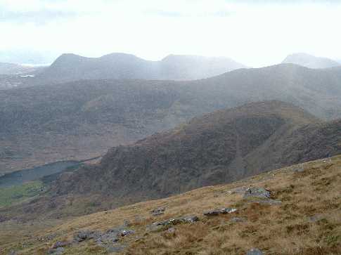
Here is a better picture of Brassel. The scramble starts near the bottom left hand corner of the picture and rises steeply in two stages. It's not very long but the exposure is significant. Linkback: mountainviews.ie/summit/317/comment/863/
Read Less
Read More
Picture: The Long Way Down
madfrankie on Brassel Mountain
by madfrankie
26 May 2009
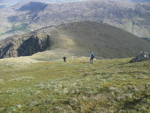
Brassel is very much the idiot half-brother of the MacGillycuddy family, and as such, is not likely to be climbed for it's own sake.
For us, it came as the final top in a walk along the eastern ridge of the Reeks. From Cnoc An Chuillinn we retraced our steps to the saddle with Cnoc An Chuillinn East Top, and headed south, down wide mossy slopes that were kind to weary knees. Nearer the col the ground gets wetter, but it's a short and easy pull to Brassel's summit.
From Brassel, the descent to the Black Valley is unrelentingly steep, and it was handy to having a fence to hold on to. I'm not sure I'd fancy having to haul myself up these slopes as a means of accessing the eastern ridge. Linkback: mountainviews.ie/summit/317/comment/3783/
Read Less
Read More
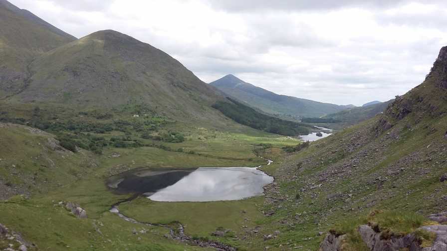
Picture: Looking north East to Brassel from Gearhameen Hanging Valley
Not as isolated as one might think
by Bunsen7
4 Jun 2018
Brassel might be positioned well beneath Cnoc an Chuillin and is quite less likely to be visited but it is in a lovely location at the western end of the Black Valley.
Hopefully this photo taken from above the waterfall to the north west of Knocknabreeda does it and Cummeenduff some justice.
For those seeking to avoid the more excessively worn tracks track in these parts but still offering the big achievement sought by some in your party, Jim Ryan's fantastic book on the Reeks suggests many an interesting loop and is a great addition to your library.
One route mentioned might see you parking up somewhere near L Reagh N (V821 813) (where you might have been if you've ever undertaken the loop of Stumpa Duloigh) and heading towards Curraghmore lake, to Curraghmore and on to Caher and then Carrauntoohil, before a descent via Cnoc an Chuillin and Brassel.
Use of MountainViews is governed by conditions and a privacy policy.
Read general information about the site. Opinions in material here are not necessarily endorsed by MountainViews.
Hillwalking is a risk sport. Information in comments, walks, shared GPS tracks or about starting places may
not be accurate for example as regards safety or access permission. You are responsible for your safety and your permission to walk.
See the credits and list definitions.


 Our Facebook page.