Members and Supporters, the MountainViews Committee requests your help to meet the costs of the website and of other activities such as insured events or publications.
Feature count in area: 29, all in Kerry,
OSI/LPS Maps: 78, EW-KNP, EW-R
Highest Place: Carrauntoohil 1038.6m
Starting Places (19) in area MacGillycuddy's Reeks: Ballaghbeama Gap, Bridia Valley End, Cronins Yard, Gap of Dunloe Head of, Gap of Dunloe Kate K, Glashaknockbrassel Stream, Glasheenoultagh Stream, Hydro Road CP, Knocknsallagh Bridge, Lisleibane Trail Head, Lough Acoose North, Lough Acoose West, Lough Cappanlea OEC, Lough Caragh SW, Lough Fada N, Lough Reagh N, Maghanlawaun Bridia Valley, Shamrock Farmhouse B&B, Tomies Lough Leane NW
Summits & other features in area MacGillycuddy's Reeks: Cen: Reeks West: Beenkeragh 1008.2m, Caher 1000m, Caher West Top 973.4m, Carrauntoohil 1038.6m, Cnoc Íochtair 746.3m, Hag's Tooth 662m, Knockbrinnea East Top 845.4m, Knockbrinnea West Top 852.2m, The Bones Peak 956.5m, Skregmore 847.7m, Stumpa Bharr na hAbhann 852.1m E: Cnoc an Bhráca: Cnoc an Bhráca 728m, Cnoc na dTarbh 655m, Strickeen 440m N: Reeks North: Knockbrack 425m, Knocknabrone Hill 353m, Skregbeg 573m NW: Gortnagan: Gortnagan Beg 298m SE: Reeks East: Brassel Mountain 575m, Cnoc an Chuillinn 954.6m, Cnoc an Chuillinn East Top 922.9m, Knocknapeasta 985.1m, Cnoc na Toinne 844.1m, Cruach Mhór 930.8m, Maolán Buí 968.9m, The Big Gun 939.9m SW: Bridia: Beann Bhán 459.5m, Beendarrig 449.7m, Beann Dubh 450.5m
Note: this list of places may include island features such as summits, but not
islands as such.
Cnoc an Chuillinn, 954.6mMountain
Place Rating ..
(Ir. Cnoc an Chuillinn [OSI 1:25,000], 'hill of the steep slope'), Kerry County in Munster province, in Arderin, Vandeleur-Lynam, Irish 900s Lists, Cnoc an Chuillinn is the 8th highest place in Ireland.
Grid Reference V82342 83337,
OS 1:50k mapsheet 78 Place visited by: 562members, recently by: kieran117, rhw, MartMc, orlaithfitz, maoris, Magic, Carolineswalsh, ConMack23, Beti13, ToughSoles, muddypaws, Kaszmirek78, Moirabourke, Lucy.boland, DeirdreM
I visited this place: NO (You need to be a logged-in member for this.)
Short or GPS IDs, 6 char: CncanC, 10 char: CncanChln Linkback: https://mountainviews.ie/summit/8/
Gallery for Cnoc an Chuillinn and surrounds
Summary
for Cnoc an Chuillinn :
Lofty bump on Reeks ridge.
Summary created by simon3
2016-06-26 15:36:06
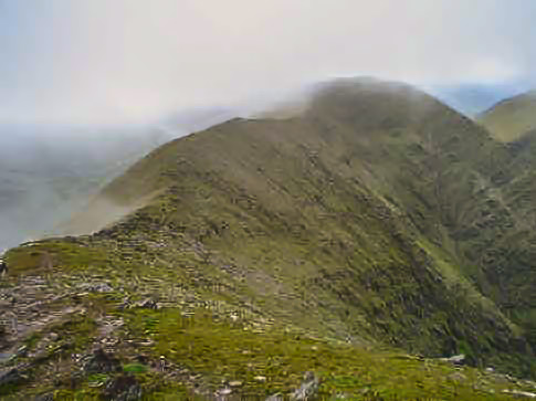
Picture: Misty ridge peak.
Cnoc an Chuillinn is a minor summit on the ridge of the MacGillycuddy's Reeks between Maolán Buí and Cnoc na Toinne.
Usually this will be visited as part of a longer ridge walk for example ascending via the Big Gun. A round trip is likely to take around 5 to 6 hours. Note that at 958m this summit and its approaches can be hazardous in poor conditions.
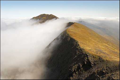
On 29th April 2006 I walked the Eastern Reeks. I started from Cronin's farmhouse and came up the Hag's Glen. Cloud cover seemed set to deny me the views that I hoped for but as I reached the top of the Devil's Ladder sunshine broke through and there were some fantastic cloud inversion vistas to enjoy. This is from Cnoc an Chuillin looking across at Caher, Carrauntoohill and Beenkeragh. Linkback: mountainviews.ie/summit/8/comment/2310/
Read Less
Read More
jackill on Cnoc an Chuillinn
by jackill
29 Aug 2004
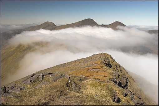
The summit of Cnoc an Chuillin just visble in the clouds to the right of centre with Lough Comin Moir Mountain in the centre of the photo as viewed from the summit of Maolan Bui. On the extreme left you can see the stoney track which leads all the way back to the Devils ladder and points beyond if you've got the energy. Linkback: mountainviews.ie/summit/8/comment/1142/
Read Less
Read More
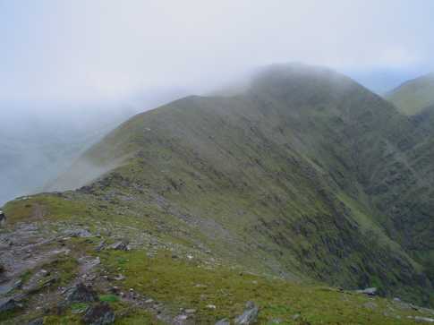
Picture: North Ridge and Cumeenmore from Summit
Cnoc an Chuillinn via North Ridge
by cha
13 Jul 2022
I followed the route described in Munster's Mountains by Denis Lynch ascending from Cumeenmore. He describes 2 routes, one climbing the gully in the SW corner of the coom and the second up the adjacent spur.
Cross the ford of the Gaddagh river at Lough Callee outflow continue until the marked loop walk turns back north, leave the path here and climb until you are vertically about halfway between the obvious boulder field at the end of the bone and Lough Callee. Contour here until you reach the stream descending from Cumeenmore, ford this and continue on it's West Bank until you reach the low plateau that rises from the West side of the lake. The route heads West up the steep slope that rises up the side of the truncated north spur. I kept well back from the cliff at the end of the spur, the ground is steep & grassy with rock outcrops that are generally easily bypassed. At the crest of the ridge there is a small col with great views into Cumeenmore and Coimin a Galasaitinn.
From here the route follows the crest of the ridge South towards Cnoc an Chuillinn and involves some straightforward scrambling on small steps and rocky gullies, but no more difficult than the Beenkeragh Ridge, and less exposed. The North ridge joins the main Reeks ridge 20-30 meters west and a little below the summit of Cnoc an Chuillinn. This is a very enjoyable semi-technical route up the Eastern Reeks, there was a heavy dew on the grass but this didn't translate to concerning conditions underfoot on the steep sections. Linkback: mountainviews.ie/summit/8/comment/23583/
Use of MountainViews is governed by conditions and a privacy policy.
Read general information about the site. Opinions in material here are not necessarily endorsed by MountainViews.
Hillwalking is a risk sport. Information in comments, walks, shared GPS tracks or about starting places may
not be accurate for example as regards safety or access permission. You are responsible for your safety and your permission to walk.
See the credits and list definitions.


 Our Facebook page.