This website uses cookies, which are small text files that the website puts on your device to facilitate operation. Cookies help us provide a better service to you. They are used to track general user traffic information and to help the website function properly.
Open to all walkers and hillwalkers whether members or not of MountainViews.
We are researching a new venue after the Hampton Hotel we used last time has shut.
This is early information about the programme, which is being constructed at
present.
We do expect to celebrate the fastest time for the Vandeleur-Lynams done by anyone.
Ellie Berry was the person who achieved this, with the huge support of the other person
in the ToughSoles duo: Carl Lange.
Another guest speaker may be arranged.
Awards Ceremony There will be our annual awards ceremony for the people who have
completed various lists or have contributed to MountainViews or walking in
general.
Photo and video awards this year we will have a popular competition for best
pictures and videos.
There will be a short presentation on new features of MountainViews and the data it is
making available to the hillwalking public of Ireland. There will be opportunities to
meet other members and summiteers. This meeting is being organised by the MountainViews
committee.
Details
Date: Fri, 1st March 2024
Venue: TBA
Time: 7:30 for 8pm start.
Charge: €15 (sorry, cash only)
Printed Annuals: will be available for sale.
Open to all.
Notes
We have arranged the event for a weekend without a rugby match as this tends to affect accommodation and attendance. We prefer Feb or early March since many people are out on the hills later in the year! And we prefer Fridays because people come from all over Ireland to the meeting and going into a weekend makes it easier for many.
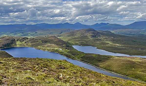
Picture
of the month - August
Viewing from Loughsalt Mountain in Donegal
- Lough Salt & Lough Greenan from the western slope. For
original track, click here.
Photo: Colin Murphy
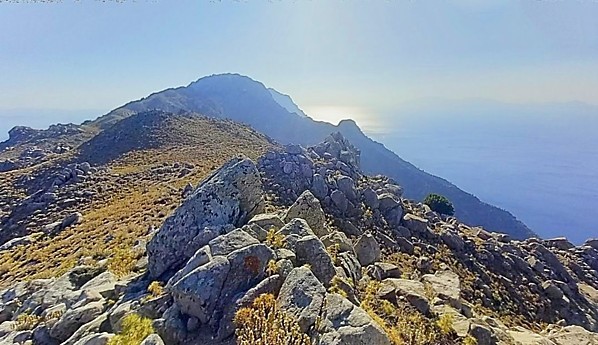
Picture
of the month - September
East face of Knocklomena in the Dunkerron Mountains
View from summit taken just after sunrise. For
original track, click here.
It has been described as Ireland’s own Uluru, it has featured in TV series such as Game
of Thrones, it is reputed to have been the spot where St. Patrick was converted to
Christianity and despite its relative small height (437m), the steep sides of Slemish
offer some cliffhanging tracks to ascend.
According to legend, having been brought to Ireland as a slave, Patrick worked as a
shepherd for a man named Milchu on the slopes of Slemish Mountain from ages 16 to 22,
and it was during this time that he turned to prayer, after which a dream inspired him
to escape, find his way home, become a priest and then return to Ireland to convert the
pagan natives. The rest is history, as they say, or legend.
Slemish has a striking appearance when seen from afar, rising majestically from the
miles of otherwise flat fields that surround it. The hill is actually the remains of the
plug of an extinct volcano from the Palaeogene era (between 25 and 65 million years
ago.) Volcanic plugs are much denser and harder than the surrounding rock, which is why
Slemish survived the subsequent glacial and climate-related erosion that flattened the
surrounding landscape.
Ascending Slemish won’t take you too long – probably about 30 minutes bottom to top, but
if you do so via the northern or central path, expect some scrambling at the very least,
and on occasion care is required as you will be clambering over boulders with an almost
vertical drop beneath you. The southern track offers a less hair-raising alternative,
although it is still very steep in parts. The top of the hill is an area of flattish
rock and grass and marked by a relatively new wooden cross of the ancient Celtic design.
The views from the summit are long ranging and beautiful and Scotland is visible on
clear days.
Geology, history, scenery & challenge all packed into one isolated hill. Sure what more
could a hillwalker ask for?
Featured Track of the Month The Moment of Tooth
This month's selection is a detailed breakdown from simon3 of the (most straightforward!) ascent
of one of Ireland's most overtly challenging mainland summits: the Hag's Tooth.
simon3 on Up and down route to the Hag's Tooth, changing its height.
Main walk Start: 10:19, End: 15:49, Duration: 5h30m, Length: 8.1km,Ascent: 430m, Descent: 416m Places: Start at V8267887288, Hag\'s Tooth, end at Start (statistics such as Ascent or Length etc should be regarded as approximate. Duration depends on the speed of the person making the track)
This route is a straightforward there and back way of getting to the Hag's Tooth, also known as Stumpa an tSaimh or Stumpeenadaff. You can start from Lisleibane car park or Cronin's Yard. As you walk in you will pass Lough Gouragh. Before that there are various rocky outcrops to the right or north of the track. One group is known as the "Hag's Teeth" but it is not until you get to Lough Gouragh that you can properly see the Hag's Tooth in all its rocky glory.
From the rough track near Lough Gouragh various possible ways up can be considered. The track incidentally goes on to well known routes up Carrauntoohil of Heavenly Gates and Brother O'Sheas
One way up is to ascend a grassy cleft in the rock visible in the picture, that starts below the peak near the path and heads nearly to the top to the right.
Route to the right under large buttress.
We opted to go to the right beside a stream.
Looking back beside the stream that we walked beside.
You will reach the flatter ground under the coum to the south of Beenkeragh and the Knockbrinneas. From here it is possible to see the profile of the Hag's Tooth and how it connects to the rocky ridge from Beenkeragh.
The top viewed from the NE. To the right of the summit is the col to start from and then the ridge to Beenkeragh.
From the col it is then possible to climb the 27 or so metres to the top. Near the top there is a dangerous exposed scramble. Much of this is tackled from the NE side, which is out of the general wind which is from the SW.
============================= My advice. Don't do this peak if you are not an experienced scrambler and if the conditions are not reasonably good. =============================
Magnified view of the top from the south.
The magnified view of the top is from the other side to the col. Near the top is a ledge from which you can touch the top. This is reached from the East side of the outcrop. So as you are within a few metres of the top, go left and then up to reach the ledge.
We also measured the height and prominence of the summit. The height shown on OSI (1:25,000) map is 650m, however we found the height to be 661.97m. The col we found to be at 634.65 so the prominence is 27.3m. The error in the height as given by the OSI is extraordinarily high.
This trip was done as part of the project by member osullivanm to climb the Vandeleur-Lynams and it was her fourth last to complete the challenge.
NORTH: Natives making a stand
Despite some invasive flora, the upper reaches of Ganiamore in Donegal boasts fine
displays of beautiful native wildflowers, along with great views, writes glencree.
glencree on Ganiamore, (Gáinne Mór):
There are harder routes up the modest peak of Ganiamore but the tourist route starts at the Stella Maris Church in Meevagh at C11001 39674 which is well signposted from either side of the Atlantic Drive. Other than at 10am on Sundays, this has ample parking. From the church car park, follow the road for a short distance and take the left fork at the T junction, then veer right at the Y junction ... ... Click here ...
NORTH: Turbines and tarmac
Colin Murphy's track taking in the twin Donegal Carns of Taobh an Leithid and Carn Traonach may
be found wanting in terms of its immediate environs, but it looks absolutely blinding in terms
of more distant prospects, with a wind farm access road easing pedestrian access to the top and
their excellent views.
Colin Murphy on So-so summits, wonderful views.
A very enjoyable 12km trek taking in two Carns with spectacular views in all directions. There is parking for several ca| walk, Len: 12.5km, Climb: 695m, Area: Taobh an Leithid, Donegal NW (Ireland) ... Click here ...
NORTH: A night on a blustery Bearnagh.
Member miriam braved a very windy Slieve Bearnagh overnight, but was rewarded with great
views of the sun setting on the western Mournes.
miriam on Slieve Bearnagh, (Sliabh Bearnach):
On a blustery Friday evening I parked at the free Trassey Car Park at J31089 31306. When I left the car I was still undecided where I was going to walk & camp. As I emerged from the gravel track of Clonachullion Woods - Spellack and Bearnagh came in to view. Walking along the Trassey River I felt the tug of the Hare's Gap drawing me up towards the Mourne Wall. I made a route through the boulder fi ... ... Click here ...
NORTH: Colin on Collin
One of the (cough) bonuses of finishing the Arderins and moving onto the Carns is
essaying summits like those athwart and around the Antrim Plateau; tops that make the Sperrins
look like Cerro Torre [Extreme peak of 3128m Argentina and Chile -- ED, another cough]. Colin
Murphy has thrown himself valiantly at three such eminences to the south-east of the Cargan
reservoir, and reports much tough going (although as a previous visitor I think his line up
Collin Top is a bit sub-optimal!). His removal of Carncormick from the end of the walk in favour
of a shorter individual visit to that top seems very sensible though, as it isn't especially
pleasant to link that summit to these ones.
Colin Murphy on Straightforward approach via track to the SW
Previous commenters have mostly approached this hill either via Mid Hill or the Quolie Reservoirs to the SE, all remarki| walk, Len: 5.0km, Climb: 203m, Area: Carncormick, Antrim Hills (Ireland) Carn ... Click here ...
NORTH: Rough, energy-sapping ascent.
Despite a gentle slope, the knee-high heather and grass make an ascent of Collin Top in
Antrim a real slog, reports Colin Murphy.
group on Collin Top, (Collann):
One approach is to start from the Cargan Dam car park at D19239 17217. Cross the dam and turn left, crossing two stiles and following a narrow trail along the south side of the reservoir, crossing over a small bridge to roughly D19759 17078, where you can strike out in a SE direction towards the summit. The climb is gentle (roughly 140m over 2km) but the terrain is very rough and covered in knee-h ... ... Click here ...
SOUTH WEST: The Mothaillin Prophecies
The declining ridge falling from Stumpa Duloigh forms the south side of the Black Valley, but
sadly cannot currently be accessed from that direction. With that in mind peter1 has essayed the
more bleak southern side of the ridge in order to visit three tops. Views are fine, but
conditions underfoot are a bit squishy. It's relatively easy to add the ascent of Stumpa to the
end of the walk.
peter1 on Knocknabreeda group: peak bagging near the Black Valley
The ascent from the valley is over quite difficult terrain - long grass, tussocks, rocks and boggy ground, lots of boggy| walk, Len: 11.7km, Climb: 646m, Area: Mothaillín, Dunkerron Mountains (Ireland ... Click here ...
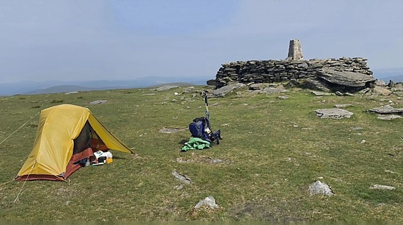
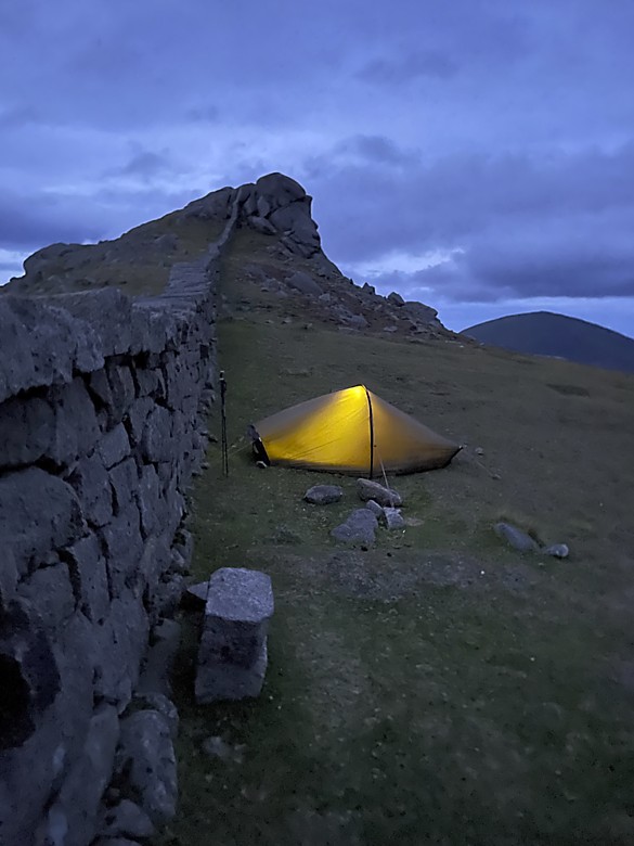
Featured summit comment
Location, Location, Location
by member: miriam
What a wonderful spot to spend the night. The photo is what makes this post a winner, but the
text - describing a night spent high in the Mournes - would make you green with envy at not
experiencing something like this for yourself. Miriam's summit comment went online on July
30 and is titled "A Camp below the North Tor of Slieve Bearnagh". Read and resolve to do
something similar.
A camp below the North Tor of Slieve Bearnagh
On a blustery Friday evening I parked at the free Trassey Car Park at J31089 31306. When I left
the car I was still undecided where I was going to walk & camp. As I emerged from the gravel
track of Clonachullion Woods - Spellack and Bearnagh came into view. Walking along the Trassey
River I felt the tug of the Hare's Gap drawing me up towards the Mourne Wall. I made a route
through the boulder field up as far as the Hare's Gap where the views of the inner Mournes and
Brandy Pad grab your attention.
My next decision was made and I turned right to climb up Bearnagh, I took a path that veers
along the side of Bearnagh and reached a river that ultimately feeds Ben Crom Reservoir. I
followed this river up the mountain where the great Tors of Bearnagh are in view. I emerged
between the North Tor and summit and decided it might be wise to seek a bit of shelter from the
wind next to the Mourne Wall on this flatter section of the mountain.
This was home for the night, the clouds moved quickly and teased me with great views -
Slievelamagan, Slieve Binnian, Ben Crom and Silent Valley Reservoirs - captivating me until the
sun went down. The wind was strong but I was safe in my tent and enjoyed the pleasure of
nature's power for the night. With heavy showers promised, I left my camp spot by 8am and made
my way back to the car coming down Bearnagh along the Mourne Wall to the Hare's Gap. I took the
higher path rather than the boulder field back down to the Trassey Track to get back to the car.
Photo: miriam, Bearnagh at night
SOUTH: A wild and worthy peak
Despite a rough ascent, Nareera in the Cahas boasts truly wonderful features - streams,
rocks formations, troughs, slabs, and loughs writes Superterence.
Superterence on Nareera:
Parked at Mass Mount Church (a ruin with roadside parking) crossroads at V824 506.
Walked East, about 100m or so, to a fence end. Up onto the ridgeline. Rough enough though long grass,boggy sections & waist high gorse. But worth the effort. You can walk along the Beara Way when you meet it or stay on the ridge. Lough Keel..... Infinity Pool amazing. Nareera is a wild and worthy peak.
Turned No ... ... Click here ...
SOUTH: Making no bones about it.
Bagging the Bones marked osullivanm’s penultimate Vandeleur-Lynam and it was worth the
wait. The last is to be Slieve Corragh, currently planned for Sat 14th Oct, see later.
osullivanm on The Bones Peak, (Na Cnámha):
The Bones had remained, for many years, the one outstanding peak which I needed to climb to complete the list of summits over 900m. It's a tricky one. I had walked the Beenkeragh Ridge before but the conditions on the day were too icy and wet to risk climbing it.
We started at V772871 (Carpark for The Hydro Road) and climbed the ridge to Cnoc Iochtar and on to BeenKeragh in misty moisty condition ... ... Click here ...
EAST: An inland lighthouse!
An historical oddity, The Spire of Lloyd in Meath sits atop a hill outside Kells, it is
a folly consisting of a 30m high lighthouse 50km from the sea, writes Colin Murphy.
group on Spire of Lloyd, (Mullach Aiti):
An 18th century folly, The Spire of Lloyd is a 30-metre high lighthouse atop a 131m rise. It is located 1.5km west of Kells just off the R163. There is a carpark, after which it is a short walk to the spire, which may only be climbed on bank holiday Mondays. There is also a ringfort nearby and a famine burial ground on the site. The hill is also marked by a trig pillar. ... Click here ...
EAST: The Long and the Shorts of it
Masochism and romance from Wexford, as simoburn takes his good lady wife for a lovely
anniversary stroll up Bree Hill, and discovers his choice of legwear to be somewhat lacking in
the stopping your legs from being shredded department. Sounds like good, character building
stuff, and there's an interesting portal tomb to visit before you presumably lose consciousness
from blood loss.
simoburn on Bree Hill - We are not in the Shire Frodo!
Bree Hill - We are not in the Shire Frodo!A rather innocent idea that turned into a bramble wack and fern and undergrowt| walk, Len: 9.4km, Climb: 241m, Area: Bree Hill, Wexford (Ireland) Bree Hill ... Click here ...
EAST: A favoured Wicklow hill
After a fairly straightforward ascent, mostly via a track, Church Mountain offers a
great view of the Blessington Lakes, writes Bunsen7.
Bunsen7 on Church Mountain, (Sliabh gCod):
A very straightforward out and back walk via forest tracks from the carpark at Hollywood Glen. It loops around and when the forest roadends at its northern terminus, head eastwards up the track along the forest's perimeter until you reach the open mountainside.
A nice stone memorial bench erected by Donard hillwalkers offers ideal seating to savour the view towards Blessington lake to the north ... ... Click here ...
EAST: Go forth from Forth
Some access issues on Forth Mt in Wexford don’t endear one to what is quite an ordinary
top, but the adjacent Carrigfoyle Trail more than compensates, says Colin Murphy.
Colin Murphy on Forth Mountain, (Sliabh Fothart):
There are access issues with this hill (Forth 'Mountain' definitely a misnomer) from both the east and north. There is actually a drivable road from the north, which you access according to Google Maps but in fact has multiple red 'Private Road' and 'No entry' signs all over the place. The other trail to the SE is similarly adorned. However, if you don't mind a longer walk, there is an official hi ... ... Click here ...
GREECE: It's all Greek to me
One wouldn't suggest that any readers seek to doggedly follow in the footsteps of eamonoc in
terms of his ascent (and more relevantly his descent) of the highest mountain on the Greek
island of Kos, Mt Dikeos, but sometimes one has to acknowledge those who indulge their
adventurous spirit, even while marvelling at the way even the most experienced (and Eamon is
VERY experienced!) can get themselves into all sorts of fun and games with just a few decisions
going awry.
eamonoc on Mt Dikeos, on Kos
In Kos lately and decided to climb the highest Mt there, Mt Dikeos, the route normally taken for this climb is from the | walk, Len: 11.8km, Climb: 729m, Area: Unid, Unid () ... Click here ...
Sorry if we didn't mention what you posted .. there's a list of all contributors for recent
month(s) later.
After many years our secretary has retired from the post. We need a new committee secretary.
Does minutes, handles some emails, assists with the Gathering .. that sort of thing.
Contact us at admin -at- mountainviews.ie
Position
In Brief
Ordinary members
For those taking an interest in the MV committee or indeed committees in general we
can also use some further "regular" committee members without a specific role. There
are many smaller quite finite projects that might suit regular members.
Publicity
MountainViews is a great resource based on over 1500 people's contributions over 21
years. Great that is if you have heard of it. And that's where we could use some
practical publicity help.
The Geeks Shall Inherit the Earth
Quite apart from programmers, MV's progress can also use help from
people who can really follow through on tasks like creating lists, checking stats,
researching place names or geology. Whether on the committee or not we value such
people's contributions.
Photo, Michaellbrawn, via Colin Murphy in forum entry
We all know the devastating effects of climate change, but in extremely rare cases, it
can result in something that might be viewed as positive. One such case is to be found
in Peru, and the amazing phenomenon of Rainbow Mountain (5,200m), 1000km SE of Lima in
the Andes. Up until as recently as 2013, it was permanently covered in snow and ice, but
due to rising temperatures, the mountain’s beauty has been revealed. The colours are a
result of 14 different mineral compositions, among them quartz, sandstone, iron,
magnesium & sulphur. Nowadays snowfall is restricted to the winter months (June-August)
and even then, the mountain is only partially covered.
It is possible to climb the mountain, but only in the company of a group and a local
guide. The actual ascent takes about 3-4 hours.
More
information.
FINISHING THE VANDELEUR-LYNAMS with osullivanm
FUND RAISING FOR THE IRISH CANCER SOCIETY
Margaret O'Sullivan
Margaret O'Sullivan is completing the Vandeleur-Lynams
Intended date: Sat, 14th October. Summit to finish on: Slieve Corragh, in the Mournes. Contact details below.
Member osullivanm, (Margaret O'Sullivan) is intending to be the 26th person and fourth woman to
complete the current MountainViews Vandeleur-Lynam list. Members will know that these are all
the summits of Ireland with a height of at least 600m and a prominence of 15m. Margaret has been
visiting Irish and other summits for decades. She is coming to the conclusion of the
Vandeleur-Lynams at a difficult time since she has cancer. In her own words:
To celebrate reaching the end of this challenge, I have decided to raise money to support
the services to cancer patients and their families provided by the Irish Cancer Society. I
would really appreciate your support in the Go Fund Me page below.
My own cancer (melanoma) has been managed since 2004. However, with great support from my
friends, I am now on the point of completing the list. All going well, I will be doing
my final one, Slieve Corragh (640m) in the Mournes in October.
In the event of a change to the arrangements, a message will be put up on the MountainViews
forum.
Disclosure: Margaret is the wife of Simon Stewart, the editor of this newsletter. Anyone finishing a major list is welcome to announce it in our newsletter. Contact the editor, as at the end.
Just how well do you understand waterproofing?
The Waterproofing of the pudding...
Many of us throw on our waterproofs with minimal thought without really understanding how
they work, and how indeed they might not. Following a 'summer' of biblical rainfall,
Alice Cronin via John Burke outline the best use of very
expensive kit.
Why is my waterproof jacket not waterproof?
Waterproof jackets are made of fabric which has a membrane with tiny pores inside a tough outer
layer. The two are bonded together. The outer layer is only to protect the inner membrane. That
membrane has holes so small that liquid water cannot pass through it. The surface tension of
water prevents it separating to a small enough drop size to fit through the pores. So rain can't
get through the membrane.
But water vapour is separated into molecules of H2O. These are not bonded together and can pass
through the pores.
When we sweat, liquid water comes out of our pores and lies on our skin. Our body heat
evaporates the sweat into water molecules which must escape to the atmosphere to carry away the
heat and keep us cool. But the molecules have to get out through the coat first.
The membrane will only let them out at a certain rate. Our rate of sweating varies with how
hard we are working and also on our individual metabolism - how we convert food into energy.
People vary in this. If we sweat too fast excess water vapour, over what can escape,
condenses to water on the inside of the membrane. The coat then feels wet inside, what Gerry
Goss called "the clammy kiss of sodden sweaty clothes". You may think your coat is leaking
rain from outside, but it happens on dry days too. The water is coming from us. It can't get
out quickly enough.
When the outside is saturated with rain, water vapour may not escape at all, greatly increasing
condensation inside. To deal with this, the outer layer is treated with water repellant to
increase the surface tension causing beads of water to form so the water does not soak into the
outer fabric but runs off under its own weight. This lets the water vapour escape freely.
What can we do to stray dry?
It's important not to wear a waterproof jacket when it's not raining. If you do
and you're working hard up a hill, the rate of water vapour escape, even for the dry jacket, may
be exceeded, causing some condensation inside. The more that happens, the quicker it happens as
the membrane pores become obstructed on the inside.
Instead, if you need insulation from cold or shelter from wind, you should wear a 'softshell'
jacket. This lets liquid water through (in both directions), so condensation will not build up
inside if it's dry outside.
When rain starts, change your softshell for a waterproof jacket. But you must stay cool. Make
sure to remove a layer first, as you may be adding more insulation making you warmer. You will
produce more sweat so the membrane can't release it, resulting in more condensation inside your
clothing.
Wash and reproof regularly
When the water repellant wears off so rain no longer ‘beads’ outside your jacket it will ‘wet
out’ impeding water vapour escape causing more condensation inside, so you feel wetter.
You should reproof your waterproof clothing regularly and more often the more you use it. Go to
an outdoor shop for a suitable product.
Rain can penetrate in seams, pockets, zips and openings for your head and hands!
See how a jacket or trousers is made before you buy it:
Check the seams are sealed with a tape on the inside. Some jackets have welded seams. Waterproof
zips - main and pocket zips - are desirable, but do cost more. They're much better at keeping
water out.
The insides of pockets should also be of the same waterproof material as the coat.
If they're not, pockets with non-waterproof zips will get you very wet around the belly.
Check the hood can be pulled tight without blocking the view and that sleeves can be velcroed
closed.
You won't stay completely dry in horizontal wind-driven rain. But you'll be more comfortable, if
a little damp, if you care for your jacket and use it properly.
MV's lists guy is glad of his Buffalo stuff in the Cairngorms. (Other suppliers are
available).
-- Alice Cronin via John Burke
Poland - Trzy Korony
The Right To Arm Bears
While visiting the south of Poland near the Slovene border, will Fergal
Hingerty discover that he's smarter than the average bear?
The bastions of Trzy Korony
In our base in the centre of Szczawicna we woke early to a warm day and a soft mist, and a
short walk led down to the river Dunajec. I was in Poland to climb the famous Trzy Korony in
Peininy, south of Krakow. We followed the river until we saw the sign for PTTK Schronisko
Orlica and strolled up for breakfast and a coffee. After polishing that off, we headed down
to the river’s edge at Przeprawa Posd Sokolica to get the raft.
This flat traditional wooden raft is operated only with the boatman’s skill, and they use large
poles to manouver across the river. The local boatsmen (dressed in traditional clothes) have
been doing this for hundreds of years to transport goods and people. We landed after a few
minutes and the climb began. The river is at 430 metres so after one hour we had climbed through
the forest to the famous sokolica peak (747m) with the 500 year old tree growing out of the
cliff edge. In nearly every postcard of this area you will see an image of this tree.
The Dunajec gorge
The views overlooking the Dunajec gorge were wonderful and we spent a while leaning on the metal
barrier taking photographs and admiring the view. We continued west on the Blue track and
crossed the peaks of Czertezik (772m), Czerteź (774m), Ociemny Wierch (744m), Szutrówka (749m)
and finally Bajków Groń (716m) at a junction.
Here we walked south alongside the yellow track before they diverged and we headed east on the
blue track, and climbed up to the peak of Zamkowa Góra (799m) and its small shrine. Then the
track zigzagged steeply through the trees until finally we reached the platform at Trzy Korony
(982m) and one of the best views I have ever seen. Trees in various colours in all directions,
snow topped Tatry mountains in the distance and the snaking river gorge below. The long and
steep climbs and descents along the track seemed very much worthwhile.
After a while we headed west and reached another junction. Taking the yellow route south we
descended through the steep sided canyon and Szopka and emerged close to the PTTK Trzy
Korony hostel. A stop for Bigos and Piwo followed and a short walk later we were at the
tourist village of Stromwice Nizne. We crossed the Dunajec river (and the border) by a
wooden footbridge and shortly afterwards started our long walk over the hills on the far
side. The blue and red tracks diverged here and we followed the blue one until we reached
the high point of Przelecz Limierz. This was close to the peak of Polianska (706m) and a
steep turn off down a yellow trail lead to the riverside track.
Within the woods on the descent
We continued on as it was starting to get dark and our head torches were turned on. After a
while there was a large roar and a crash in the woods. Edyta said “Bear” (pronounced beer in
Polish) to which I replied “Yes, I would love a beer”. We continued on and on into the gloom and
soon the lights of the Slovak village of Lesnica were getting closer and closer. Suddenly a much
louder roar and crash a lot closer came from the woods. Edyta said Big Bear (Beer)…..“We will
definitely have a big beer after this”.
The dogs of the village came out to greet us and we walked through the village to the waterfront
track and were soon back in Szczawnica. It was time to pop into the local tavern for the big
beer we had discussed and in answer to the age old question “Does a bear S**t in the woods ?”
Well we did not hang around to find out! The route was 26.3 Km with an ascent of 1,510 metres. A
great walk even if a little challenging in unexpected ways on occasion!
The route
Sczawanica is a tourist town so lots of accommodation. It is south-east of Krakow and east of
Zakopane with numerous buses available to get there.
Information
...
-- Fergal Hingerty
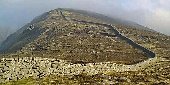
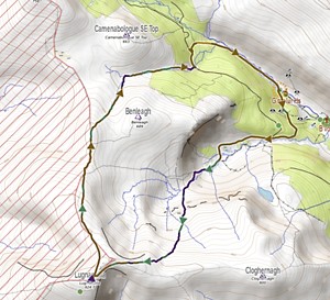
Lugnaquilla on a warm day.
A Walk around the Prisons of Lug by Michael Guilfoyle
Trapped by the steep prisons for a warm day in 2021, our illustrious author
had only a bottle of wine to keep him company.
The plan was to overnight on Lug, Aongus and myself. It was during some of the hottest days
of last Summer, perfect weather for overnighting, warm, calm and clear, something we had
often talked about but neither of us had ever done.
The way up in this older MV track approximates our author's route.
The route chosen by both of us was up from Baravore Ford, working our way up the great
glacial “steps” of the spectacular Fraughaun Rock Glen, swinging north towards
Ben Leagh and picking up the long, well-worn path to the summit, all the way bordering the
Glen of Imaal Artillery Range.
All very simple, except it was hot, and had been hot for days, I mean very hot. I’m not
sure what was the temperature at the nearest recording station, but the forecast maximum for
that day was certainly in the very high 20s Centigrade, and in favoured places like deep
Glenmalure no doubt it would top 30c. Great weather to overnight but not for dragging
a full back-pack, with all the accoutrements which accompany that, including the inevitable
bottle of wine, all of the nearly 800 weary meters to the summit!
Aongus was working that Friday and wouldn’t be able to join me on the summit until
around 7pm that evening. I didn’t have the same time constraints, and so, I made the
wise decision to ascend early in the morning instead of accompanying him on a rushed and
inevitably midgey, hot evening. That way I’d break the back of the pull up long before
the early July heat would start baking the moisture out of the hillsides, and the energy out
of any hiker mad enough to go out in that midday sun.
The problem was I had happily and uneventfully gained the summit sometime after 10.30am,
spoiled for choice of camping spots on that wide summit plateau, so familiar to me from
years of hiking. But you might ask: how is that a problem? Well, I was facing into more than
8hrs alone on the summit, before Aongus got there. And I’d sworn that I would keep
that to-be-shared bottle unopened until he arrived and we could celebrate the Lug sunset
together over a nice meal!
The camp on Lug.
But again, you might think, what more wonderful place in Ireland to hang out, take it all in,
wander and explore than the highest point in Ireland outside of Kerry?
And to be that
person, looking down on everyone else, except perhaps for a few on Brandon or the high
summits of the McGillycuddy’s. [ED's whataboutery: Galtymore] I would be in the elite
company of perhaps some distant
Kerry hikers for all of those sunny hours, and for some of them I would no doubt be the
highest person in the country.
Imprisoned ..
So, I made my coffee and sat on the by now warm slate stone of the summit outcrop cairn, and
nobody came, not a soul to share the wonder of where I was, nor would they until much, much
later. And initially I didn’t miss anyone, and I was very happy where I was.
But the heat was building, there was no stir in the air and the high sun didn’t afford
any shelter whatsoever on that summit space, enclosed and bounded by the great “prison”
precipices of that special mountain. In a strange, way I was imprisoned by these “prisons”!
St Emilion getting hot ..
For want of something to do, I made my lunch early, noting that my bottle of nice red was
overheating where I had placed it under the fly sheet of my tent, the bottle even hot to the
touch! There was a South of France feel to the day, and, accustomed as I was to those kinds
of days, I knew a glass of red might have equipped me better to deal with the heat. But
I’d promised Aongus we’d share it over a meal around 7pm, still many, many hours
away. Would I last until then? I kept asking myself.
I looked around as the day stretched ahead of me. I hadn’t brought a book or earphones,
and so I occupied myself with repeated perimeter walks around the rim of the “prisons”,
sitting down and sometimes lying down on the lip and perusing each one, noting access
routes, the meander of streams, distant hills and great white windmills, the heat haze over
the midlands, a hint of the Blackstairs and slightly threatening great towering midland
thunderheads!
Succumbing ..
Around 4pm, with about 3hrs to go before Aongus was due to arrive, I succumbed and opened my
(our) bottle of St Emilion, and sipped two glasses looking north into the fastness of
Wicklow Mountains summits, with the sun on my back – and yes, I had brought a proper
wine glass! And the heat and the wine combined as they do, and suggested to me that I should
take to the tent for a snooze. Big mistake! Yes, I was shaded but after maybe 20 mins
of the kind of tent heat all of us who have backpacked in hotter climes will know, I was out
again squeezing my body into the now welcoming shade thrown eastwards by the cairn, and
breathing in the beginnings of movement in the previous eerily still summit air.
And yes, eventually, cool evening airs worked their magic on my hot, slightly hungover head,
and my enjoyment of where I was returned. Aongus arrived at 7pm, wondered about my
discomfiture and red-faced sunburn, and how or why the bottle was half empty. I happily
presented it to him, and we ate and watched a low and slow midlands sunset
away up towards north Kildare.
And a deep blue darkness came up behind us out of the east, reaching across the sky around
and above us, draping the summit as it chased the light out to the west, all the way to the
horizon, eventually. The last outlines of the distant hills dissolved into the night
sky, and town and village lights twinkled away down in the cooling night air. And high in
the sky the stars came out, and the summit cairn stood proud against the night sky! And,
I mused to myself, it was all well worth the wait.
Let's suppose you have been looking at local route descriptions or EastWest mapping for the
Blackstairs and you want to know where "Suidhe Laighean" is located? Google
result:
It now appears in a Google search. It's also currently first on Bing and DuckDuckGo
MV isn't always the first result on Google, but it's usually on the first page for such
searches.
MountainViews has listed all of the different names on EastWest maps (with
their permission). We are doing this as a public service because EastWest names and the absence
sometimes on their maps of official or widely used names can be confusing. We believe that the
process of simplifying and standardising names should go ahead. As far as the Republic is
concerned for hillwalkers we support Logainm with its approach of "One definitive name in Irish
and one in English for all places".
Here's a few others that you will find using a search engine and MV
EastWest
MV / official name
Cíop Mhór
Kippure
Stol a' tSaighdiúirí
Knockanaffrin
Mulnahogue
Binn idir an dá Log
Dubh Ais
Djouce
SITE NEWS
Video Changes
Update on Video Content:
An exercise was completed to review all videos currently available in the MountainViews website
to ensure the following:
all available video links working properly
remove video links that were no longer working
include location coordinates for videos uploaded which were not already captured
include a number of additional videos which may be of interest
There are now a total of 294 video links listed in the MountainViews site covering a broad
range
of our mountains - we would like to continue our efforts to provide video footage capturing
some
of our lesser known mountains so that MountainViews users can get a sense of terrain & route
options from a video perspective. If you have any video footage that you think would be of
interest - please contact Miriam at: secretary@mountainviews.ie
Mobile Version (repeat with some updates)
Change to and from new version.
MountainViews new version is gradually emerging as we have mentioned before. You can switch to
and from it using the menu option, or you can add ?RWD at the end of its url. For example to see
our data Djouce, mentioned earlier you could enter
Remember, MV new version isn't just for mobile devices, it is what is known as
"Responsive", that is you can use it at a variety of widths much greater than the old system,
from mobile narrow width to wide laptops. The page rearranges to try to maximise the usefulness
of the space that's available.
The MountainViews App Updated information
The new version also is available as an "App", that is a program available on
Android and Apple mobile devices, which you can install. This has a lot of advantages for users.
Potentially an App can start much faster than a webpage. In fact it can start and do something
at least minimal where there isn't any internet coverage - obviously an advantage for
hillwalking.
Installing the MV app may appear as an option in your browser. This is because the method of
turning
into an App that we are using doesn't require that go to an App store (though it can do). It can
be installed through a browsers such as Google Chrome, Safari, Firefox, Android Chrome Browser
etc. The installation will appear as option in one of the browsers menus. That sounds a bit
vague, I know, but this is because different browsers and different devices do it differently.
Wording will appear similar to "Install as App".
You can try this on mobiles and even some desktops as and when the option is available, however
initially it is purely experimental and will not give some of the fast start and offline
advantages of an App.
Working with Apple devices.
We are glad to confirm that initial testing with an iPhone and an iPad confirmed that the app
version of MV was installable and functioned.
Uploading GPS tracks.
The menu option Walks | Upload a track (N£W) brings you to a new page to upload a .GPX file.
You can try this by clicking here.
This, hopefully improved, page should make it easier to add tracks to MV. It offers drag and drop as well as file selection. On a mobile device one way of working is to store a .gpx file from whatever application you are using to record tracks and then browse to it. Feedback wanted to admin -at- mountainviews.ie
Recent Surveying
Mtnindex
Area
Placename
Height
Prominence
Accuracy
Map GR
5117
Kerry Coastal Hill
Dunmore Head
97.3
0.1
V30621 98203
5115
Kerry Coastal Hill
Clogher head
116.4
0.1
Q30668 02719
5116
Kerry Coastal Hill
An Ghráig
165.7
0.1
Q31614 02207
30
Brandon Group
Benagh
822.4
0.1
Q46909 11926
35
Brandon Group
Faha Ridge
809.2
0.1
Q46437 12048
193
MacGillycuddy's Reeks
Hags Tooth
662.0
27.3
0.1
V80958 85044
117
Midlands SW
Keeper Hill
691.6
0.1
R82394 66704
659
Midlands SW
Boolattin
446.6
0.1
R80410 66127
The biggest surprise was from the results for the Hag's Tooth, probably the Vandeleur-Lynam
requiring the most serious scrambling. Previously we had understood from the OS that its height
was 650m
with a prominence of 15m. Now anytime a MV surveyor sees a prominence of 15m the immediate
question
is "is this more or less than 15m and hence is it confirmed as a V-L or not one". However the
measurement found that the col between the Hag's Tooth and Beenkeragh was at 634.7m, very
similar to
what we understood. But it's height was completely different. The top is at 661.97 or rounded to
10cm that's 662.0m This is therefore 12m higher than the OS states on their 1:25000 map where it
is explicitly given. Its prominence is therefore 27.3m, confirming it is a V-L and almost making
it as an Arderin. This is the largest error we have ever found on an OS map.
Other changes this time include a change to Anglesey Mountain in the Cooleys. Its height on
EastWest has dropped to 421 and its prominence is now 26m, thus meaning it leaves the Carn list
of summits between 400 and less than 500m with 30m prominence. Thanks to EastWest and Chris
Crocker for this one.
CHALLENGE
A place for those interested in Challenge Walks
The Fei Sheehy Challenge
2023 A mighty Challenge over three days to cross the Galty, Comeragh and
Knockmealdown Mountains. Organised by Na Sléibhte Hillwalking Club - There are three
variations of walks over three great mountain ranges.
Many of these Walks can see full registration very quickly! In the case of the ever popular
Fei Sheehy Challenge for example, once the participants number 90 souls - registration
closes until the following year! So be sure to avoid disappointment as they say…
Be sure to remember also, how the Challenge Walks Calendar will continue to update and
publicise as more and more of these great Events are confirmed throughout the year.
So now as we’re starting to see a co ck-step in our daylight hours and barring the next
serving of wild weather or a “cold snap” that seem to be a whole lot more
frequent these days… there’s no real acceptable excuse for not getting muddy
and
boggy upon a hill or two in your own near vicinity.
This forthcoming year will see many a Hillwalking Club only delighted to welcome back the
avid Challenge Hillwalker as old friendships are renewed and new ones forged true.
Support a Challenge Walk Near You!
Onwards and Upwards Boys and Girls,
Keep Safe and Enjoy Your Day!
Jim Holmes.
Reports of many of the Challenge Walks and indeed news, blogs and more - can be found on . . .
CHALLENGE WALKS NEWS, REPORTS, BLOGS & MORE . . .
mountainviews.ie/challengenews
You should be able to find this link easily off the main Challenge Walks Page.
Another feature that's closely related to Challenge Walking and other services provided by
MountainViews is our page listing Irish Compleatists of the Scottish Munros. We could use some
recent compleaters reports for this!
mountainviews.ie/IrishMunroists
See some more info below on this new feature.
Using MountainViews Notifications - Daily, Weekly or Monthly.
MountainViews offers a way of being notified when new contributions appear on the
website.
You can request a notification with a selection of new items that have been added to be sent to
you by email. The main way of doing this is to click
On main screen click for notifications.
Same for new design.
After you click on the button, then, in each week that there new contributions for, you will
receive an email listing the more prominent ones. You can change this to each day or each
month.
There are various other notifications available, such as for following a contributor or
several contributors. If you select more than one sort of notification then you will still
receive one email per period, with different sections.
Each notification has a link to the original place in the website where the contribution can
be found for further reading.
Here is what a notification might look like in your inbox.
You can have daily, weekly or monthly notifications. You can turn them off or
control when they are to appear at any time.
The MountainViews ANNUAL 2022, brought out in 2023.
For 2022 the Annual has 68 pages in 18 Articles about walking on hills, mountains, coast and
islands here and abroad.
(Information above and below are since we last presented such figures, which is generally a
month but can be longer when we don't have an html newsletter.)
Our contributors to all threads this month:
Blacach (1), BrianKennan (1), Bunsen7 (1), Colin Murphy (20), David-Guenot (1), Djouce (2), Fergalh (12), Harry Goodman (1), Jim Holmes (1), JohnRea (1), Lauranna (7), No1Grumbler (1), Onzy (9), TommyV (3), Ulsterpooka (1), billbaggins (3), bogllama2210 (3), caiomhin (1), eamonoc (8), eejaymm (1), glencree (1), Communal summary entries (61), markwallace (2), mcgrathe (2), mh400nt (2), mickhanney (5), miriam (1), nupat (4), ochils_trekker (4), osullivanm (2), peter1 (4), quarryman (1), roscorrocket (1), sandman (2), simoburn (3), simon3 (9), wicklore (1)
For a fuller list view Community |
Recent Contributors
Summary.
MountainViews now has 10290 comments about 1742 different
hills, mountains, island and coastal features out of the total in our current full list
(2205 on island of Ireland). We want to get a good gps track showing each of the
major ways to visit each
of these places and summits in Ireland. If you see an option to add a "Short Summary" then do
please consider creating one since another objective is to have a short summary for every summit
and island and coastal feature in Ireland. There's quite a few
opportunities for you to be the first to comment on a place, not so many on summits, however
lots of opportunities for islands and coastal features as we bring them out. We also have around
2700 shared GPS tracks, mostly in Ireland. Apart from a few popular areas, there is a need for
more routes in many different areas. Plain shared tracks without descriptions are welcome
however if you have time then do please add route descriptions with photos.
NOTICES
Notices
If you are contributing, please be careful to respect the interests of landowners.
Suggest access routes well away from houses, gardens or that could conceivably impact
farming activities. When walking, keep away from gardens or farm buildings. Use stiles
or gates wherever possible. Never do anything that could allow animals to roam where the
farmer did not intend. Ask permission where appropriate.
Take care if parking and do not obstruct roads, lanes and field entrances to access by
farm machinery, which can be large. Exercise your dog in parks or forests but avoid
countryside or open hillside where they may worry sheep.
Report suspicious activity to the police forces, as below.
If your car is broken into in an upland area report it to the PSNI or Gardai as this
will help them be aware of the issue and tackle it in future. Store the numbers. In
Northern Ireland use the PSNI non-emergency number 0845 600 8000. In the Republic you
can find the local Garda District HQs phone numbers at www.garda.ie/Stations/Default.aspx.
Specifically for the hotspot of Wicklow: the Garda Divisional Headquarters in Bray is 01
6665300.
If you hear of a problem area or route, write it up in MountainViews
which does everyone a service.
Report rubbish tipping in the Republic - ring EPA hotline 1850 365 121
Report recreational quads in national park area (in which they are banned). They are
also banned in the Mournes. For Wicklow please phone the Duty Ranger: 087-9803899 or the
office during office hours Telephone: +353-404-45800. For the Mournes ring the PSNI (as
above) or contact Mournes Heritage Trust. Put these numbers in your phone, take regs
etc. Let MV know of contact numbers for other areas.
If you have visited some of the less well known places, we would appreciate a place
rating and also "Improve Grid Ref" for summits and other places.
If you find errors in the basic information about places such as in their names, their
heights, county name etc please use the "Propose Places Database Change" option.
If we can, let's make MV have more than one route up a summit or to a place so as to
reduce the tendency for paths to appear. Your grid refs in comments for different
starting points show up on MountainViews maps as well as shared GPS tracks.
Visit the MountainViews Facebook page.
Visit the Challenge Walks Ireland page (jointly managed by MountainViews)
This newsletter
This newsletter
Editor: Simon Stewart, Homepage:
www.simonstewart.ie
Assistant editors: Colin Murphy
Summit comment reviews: David Murphy
Challenge Info: Proinsias, Jim Holmes
Track reviews: Peter Walker
Book reviews: Aidan Dillon, Peter Walker, Mel O'Hara
Videography: Peter Walker
Graphics design advice & cartoons: madfrankie
Development & support volunteers: Vanush "Misha" Paturyan
USING MATERIAL FROM THIS NEWSLETTER.
Other websites can link to MountainViews newsletters at
for example: /newsletter
For clubs, individual users, non-commercial users some specified items in this
newsletter (principally, graphics, quizzes etc) are explicitly shown as Licensed for
reuse using this licence: CC
BY-NC-SA 4.0 Display link to MountainViews.ie as part of your attribution.
Material is subject to our conditions of use, see mountainviews.ie/conditions/
Commercial users for individual items: please contact us.
(If you have cookies on in your browser then you may be prompted as to username/
password. If you forget the password, the login page can email you a
replacement.)
DONATING TO MOUNTAINVIEWS Please help with running costs.
CHANGING EMAIL ADDRESS
Member, PLEASE make your own changes using the Settings feature, top right of the
page.
Only, if you can't get this to work let us know by email at admin -at- mountainviews.ie
Include the email address you got this at or your screen-name guestuser.
UNSUBSCRIBING
Alternatively let us know by email at admin -at- mountainviews.ie
Include the email address you got this at or your screen-name guestuser.
 Annual 2024


 simon3 on Up and down route to the Hag's Tooth, changing its height.


 Location, Location, Location